Mount Dora is a city in Lake County, Florida, USA. As of the 2010 census it had a population of 12,370, and in 2019 the population was estimated to be 14,516. It is part of the Orlando-Kissimmee, Florida, metropolitan statistical area. Founded in 1880, Mount Dora is known for its small-town southern charm. It has many antique shops in the downtown area. The downtown area overlooks Lake Dora. Mount Dora is home to one of three freshwater lighthouses in Florida. It hosts many monthly festivals and is known as the “Festival City”.
| Name: | Mount Dora city |
|---|---|
| LSAD Code: | 25 |
| LSAD Description: | city (suffix) |
| State: | Florida |
| County: | Lake County |
| Elevation: | 167 ft (51 m) |
| Total Area: | 9.50 sq mi (24.60 km²) |
| Land Area: | 8.35 sq mi (21.62 km²) |
| Water Area: | 1.15 sq mi (2.98 km²) |
| Total Population: | 16,341 |
| Population Density: | 1,957.24/sq mi (755.74/km²) |
| ZIP code: | 32756-32757 |
| Area code: | 352 |
| FIPS code: | 1247050 |
| GNISfeature ID: | 2404318 |
| Website: | www.ci.mount-dora.fl.us |
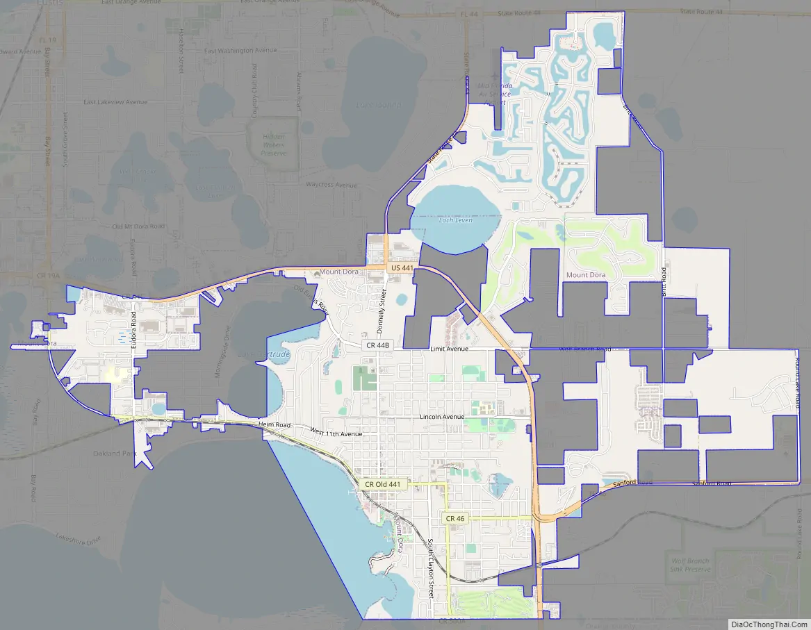
Online Interactive Map
Click on ![]() to view map in "full screen" mode.
to view map in "full screen" mode.
Mount Dora location map. Where is Mount Dora city?


History
The town of Mount Dora began in 1874 when the area was settled by David Simpson, his wife, and two children. In 1880, Ross C. Tremain became the town’s first postmaster, and later a major real-estate developer for the area. A post office called Mount Dora has been in operation since 1883. Tremain named the unincorporated village Royellou, after his children, Roy, Ella, and Louis.
The community was renamed for Dora Ann Drawdy, who was an early settler of the town in the mid-1880s. In 1846, the surveyors named Lake Dora after her, and in 1883, the town was renamed after the lake. The Mount in Mount Dora reflects the fact that the town is on a plateau 184 feet above sea level. In addition to this, Dora is memorialized through Dora Drawdy Way, an alleyway located in the downtown area.
The town became a popular winter retreat for hunters, fishermen, and boaters, and in 1883, the Alexander House, a two-story hotel, was opened. The Alexander House has been renamed several times and was listed on the National Register of Historic Places in 1975. A railroad came to town in 1887, followed by an orange-packing house, fertilizer factories, and a cannery. The town was granted a charter in 1910 with John Philip Donnelly as its first mayor; the town had 371 residents at the time.
In the 1920s, Mount Dora began to grow significantly, both in residential development and business development. Mount Dora began investing in public infrastructure, including streetlights, a water system, curbs, and paved roads. The first two public parks were created and the Mount Dora Community Building was built largely from funds raised by Mount Dora residents. The building has since served as the city’s performance and meeting venue.
In 2013, the City of Mount Dora began to develop an area of land called the Wolf Branch Innovation District. That plan was developed as the Wekiva Parkway started to expand and State Road 453 opened right into Mount Dora. The Wolf Branch Innovation District is currently being developed to become a high-technology and life-sciences business area. Expansion of infrastructure and roadways continues as Mount Dora prepares for future growth.
Historic sites
The following are listed on the National Register of Historic Places:
- Blandford
- John P. Donnelly House
- Lakeside Inn
- Old Mount Dora Atlantic Coast Line Railroad Station, home to the town’s chamber of commerce
- Witherspoon Lodge of Free and Accepted Masons, No. 111
The Mount Dora Historic District is a U.S. historic district in downtown Mount Dora. The district is roughly bounded by 3rd Avenue, 11th Avenue, Clayton Street, and Helen Street. It was added to the National Register of Historic Places on October 1, 2009.
Mount Dora Road Map
Mount Dora city Satellite Map

Geography
Mount Dora is located in eastern Lake County. It is bordered to the south by Orange County. U.S. Route 441 passes through the city, leading west 5 miles (8 km) to Tavares, the Lake county seat, and northwest 25 miles (40 km) to Orlando.
According to the United States Census Bureau, the city has a total area of 9.2 square miles (23.8 km), of which 1.2 square miles (3.0 km), or 12.51%, are covered by water. Overlooking Lakes Dora, Gertrude, and Beauclair, Mount Dora is situated on a plateau rising to 184 feet (56 m) above mean sea level, or slightly more than 100 feet (30 m) above the level of the lakes.
See also
Map of Florida State and its subdivision:- Alachua
- Baker
- Bay
- Bradford
- Brevard
- Broward
- Calhoun
- Charlotte
- Citrus
- Clay
- Collier
- Columbia
- Desoto
- Dixie
- Duval
- Escambia
- Flagler
- Franklin
- Gadsden
- Gilchrist
- Glades
- Gulf
- Hamilton
- Hardee
- Hendry
- Hernando
- Highlands
- Hillsborough
- Holmes
- Indian River
- Jackson
- Jefferson
- Lafayette
- Lake
- Lee
- Leon
- Levy
- Liberty
- Madison
- Manatee
- Marion
- Martin
- Miami-Dade
- Monroe
- Nassau
- Okaloosa
- Okeechobee
- Orange
- Osceola
- Palm Beach
- Pasco
- Pinellas
- Polk
- Putnam
- Saint Johns
- Saint Lucie
- Santa Rosa
- Sarasota
- Seminole
- Sumter
- Suwannee
- Taylor
- Union
- Volusia
- Wakulla
- Walton
- Washington
- Alabama
- Alaska
- Arizona
- Arkansas
- California
- Colorado
- Connecticut
- Delaware
- District of Columbia
- Florida
- Georgia
- Hawaii
- Idaho
- Illinois
- Indiana
- Iowa
- Kansas
- Kentucky
- Louisiana
- Maine
- Maryland
- Massachusetts
- Michigan
- Minnesota
- Mississippi
- Missouri
- Montana
- Nebraska
- Nevada
- New Hampshire
- New Jersey
- New Mexico
- New York
- North Carolina
- North Dakota
- Ohio
- Oklahoma
- Oregon
- Pennsylvania
- Rhode Island
- South Carolina
- South Dakota
- Tennessee
- Texas
- Utah
- Vermont
- Virginia
- Washington
- West Virginia
- Wisconsin
- Wyoming


