Gowanda is a village in western New York, United States. It lies partly in Erie County and partly in Cattaraugus County. The population was 2,512 at the 2020 census. The name is derived from a local Seneca language term meaning “almost surrounded by hills” or “a valley among the hills”. The Erie County portion of Gowanda is part of the Buffalo–Niagara Falls metropolitan statistical area, while the Cattaraugus County portion is part of the Olean micropolitan statistical area.
The village is partly in the Town of Collins in Erie County and partly in the Town of Persia in Cattaraugus County. Bordering Gowanda is the Cattaraugus Reservation, which has a majority population of Seneca. Numerous European Americans live on the reservation in leased properties.
Gowanda Airport (D59) is a general-aviation grass strip. It is part of the Gernatt Family of Companies’ land, located northwest of the village.
Zoar Valley on Cattaraugus Creek east of Gowanda features over 2,000 acres (8.1 km) of wilderness, hiking trails and waterfalls.
| Name: | Gowanda village |
|---|---|
| LSAD Code: | 47 |
| LSAD Description: | village (suffix) |
| State: | New York |
| County: | Cattaraugus County, Erie County |
| Elevation: | 761 ft (232 m) |
| Total Area: | 1.61 sq mi (4.17 km²) |
| Land Area: | 1.59 sq mi (4.13 km²) |
| Water Area: | 0.02 sq mi (0.04 km²) |
| Total Population: | 2,513 |
| Population Density: | 1,577.53/sq mi (609.16/km²) |
| ZIP code: | 14070 |
| Area code: | 716 |
| FIPS code: | 3629630 |
| GNISfeature ID: | 0951430 |
| Website: | villageofgowanda.com |
Online Interactive Map
Click on ![]() to view map in "full screen" mode.
to view map in "full screen" mode.
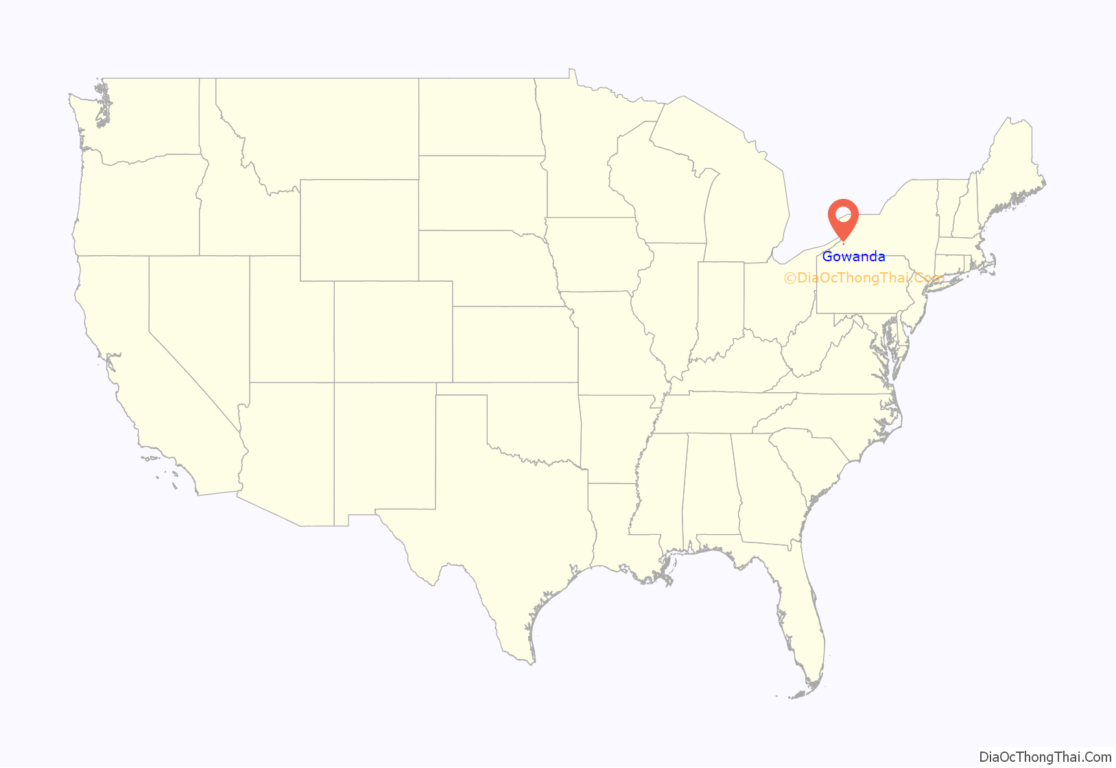
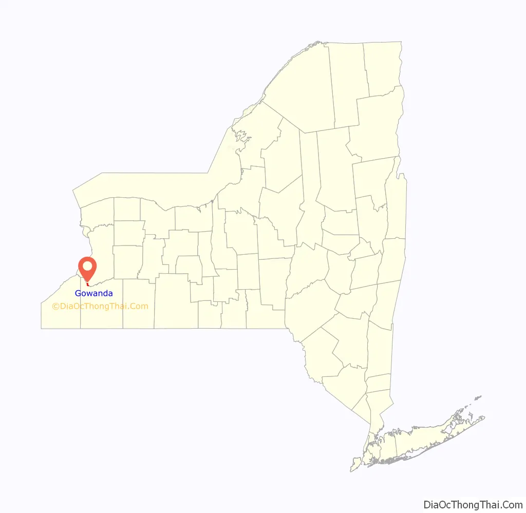
Gowanda location map. Where is Gowanda village?
History
Early habitation by American Indians
The area was first inhabited during the Stone Age by nomadic Algonquian peoples. An Algonquian earthwork mound from the first or second Stone Age is located on a farm in the area of Rosenberg along Zoar Valley near Gowanda. The mound is believed to be about 3,500 years old. Artifacts including spearheads, copper heads, and stone implements of a crude nature have been excavated from the site. In the latter half of the 14th century, Iroquoian-speaking peoples traveled to the area and lived along Cattaraugus Creek. They were proud, considering themselves to be “chosen people”. Other tribes lived in the area around this time. The powerful nations of the Iroquois Confederacy defeated the Erie people (also an Iroquoian-speaking tribe), driving them out of the area or assimilating captives by adoption in certain clans. About this time, the Five Nations of the Confederacy coalesced as distinct peoples. They made a pact of cooperation rather than warfare. They controlled much of present-day New York state west of Albany and the Hudson River.
After the Revolutionary War, the American government secured land treaties with the Iroquois nations in western New York in 1784 and 1788. Because the majority of the nations had been allies of the British, they were forced to cede most of their lands in New York after the British defeat and United States independence.
In 1796 and 1797, Robert Morris purchased extensive lands in the upstate areas, mostly American Indian lands, and mortgaged them to the Holland Land Company of Willem Willink and 11 associates of Amsterdam in the Netherlands. Excluded from his purchases in 1797 were territories for ten American Indian reservations within the state, with the Cattaraugus Reservation of 42 square miles (110 km) among these. Thereafter, two land offices of the Holland Land Company were opened in Batavia, New York, and Danby, Vermont. Many early settlers to Gowanda were from the Danby area, and many were Quakers.
Settlement and incorporation
Originally called “Aldrich’s Mills” after the first European-American settler, Turner Aldrich, the European-American village was settled in 1810 and began to develop. He and his family of three sons and three daughters traveled up Cattaraugus Creek from Connecticut, taking 707 acres (286 ha) of land, comprising a large portion of what is Gowanda today. Aldrich built a sawmill and in 1817 a gristmill. Records of farmers coming from a 30-mile (48 km) radius for their grain to be ground are held by the historical society. At that time, farmers and pioneers traveled along American Indian trails through the dense forest, with their wagons being pulled by oxen.
Jacob Taylor, a Quaker missionary from the Friends Yearly Meeting of Philadelphia, was sent in 1809 to serve the American Indians in the area. Taylor Hollow is named for him. In 1811, he built, owned, and operated a sawmill and gristmill. Other missionaries accompanied Taylor, and though they called themselves a “family,” they were not related.
The village later adopted the name “Lodi”, though there was confusion in mail delivery due to “Lodi” in Seneca County, New York (the post office officially used the name “West Lodi” for what is now Gowanda to distinguish the two). When the village was incorporated, it dropped that name, although the post office retained the name “Persia.” The Seneca in the area had once identified this place as Juc-Gowanda, meaning “a valley among the hills”. The settlers adopted the name “Gowanda” for the village. It was first incorporated in 1848, and was re-incorporated in 1878 under a new state regulation. At the latter time, the village extended its territory to annex the nearby hamlet of Hidi.
19th century
Most of the village in Erie County, made up of wooden buildings, was destroyed by a fire in 1856. Another fire in 1875 burned many businesses in the Cattaraugus part.
A historical book about Gowanda identifies 120 men, including Caucasians and American Indians, who were Gowanda residents and who fought in the Civil War in New York regiments. The same book also identifies six men who had been Gowanda residents, but who enlisted and fought in the Civil War with regiments from Ohio, Wisconsin, Pennsylvania, and Michigan.
Long associated with Gowanda although located outside its boundaries, the Thomas Asylum for Orphan and Destitute Indian Children (also known as the “Thomas Indian School”) was built following a gift of 50 acres (20 ha) of land on the Cattaraugus Reservation. The school was incorporated in 1855. In June 1856, the institution opened and was immediately at capacity in housing 50 orphaned American Indian children. The Thomas Asylum housed and schooled orphaned American Indian children for decades, until the latter part of the twentieth century.
In 1894, the Erie County Legislature passed an act that authorized establishment of the Homeopathic State Hospital (later known as the “Gowanda Psychiatric Center”) in Gowanda and Collins. Erie County purchased 500 acres (200 ha) of land for the hospital site, known as the “Taylor tract”. When the State Care Act was effected in 1894, the land was transferred to the State of New York, which conveyed it to the state hospital.
Since the late 20th century, the facility has been adapted for use as a correctional center. It borders Taylor Hollow Road in Gowanda. The road was named for the original owner of the land that was purchased and used for the State Hospital.
20th Century
Important industries that flourished in Gowanda during the twentieth century, but which also polluted the adjoining Cattaraugus Creek, included the Peter Cooper Corporation Glue Factory and the Moench Tannery. The first tannery in Gowanda was begun by Samuel T. Munger in 1829, although one was already in operation by Smith Bartlett since 1815 in Collins. In 1829, to tan one side of leather in six months was considered quick work. Other tanneries in operation in Gowanda were by the Benton Brothers; K. Webster (which was purchased by Agle & Sons in 1860); and Albert Gaensslen. In 1852, Albert Gaensslen converted the former wool factory in Gowanda to a leather plant with 12 liquor vats. The Gaensslen Brothers tannery manufactured only shoe sole leather. Gaensslen Brothers tannery was established in 1855; reorganizing as Gaensslen, Fisher & Company in 1896, following the partnership with E.C. Fisher. In 1879, the Gaensslen Brothers tannery “included 250 liquor vats and shipped 20,000 sides of sole leather to Cleveland each year.” Additionally, the Agle & Sons tannery was expanded, containing 40 liquor vats and annually finishing 700 sides of leather by 1879.
A glue factory was originally started in association with the Gaensslen Brothers Tannery in 1874 in order to utilize the tanning waste. At that time, 30,000 pounds (14,000 kg) of glue was produced annually. The first construction of Richard Wilhelm’s Eastern Tanners Glue Company plant began on May 5, 1904. In 1898, tanning factory waste from the now-reorganized Gaensslen, Fisher & Company tannery produced 300,000 to 400,000 pounds (140,000 to 180,000 kg) of glue. In 1899, the tannery was purchased by C. Moench & Sons. Although it was purchased by the Brown Shoe Company in 1925, it existed as the Moench Tanning Company, Incorporated.
A 1976 historical book about Gowanda states that the Eastern Tanners Glue Company begun by Richard Wilhelm, and later purchased and operated by the Peter Cooper Corporations, was “the largest glue making plant in the world.” Gowanda, therefore, was known as America’s glue capital.
21st century
The Bank of Gowanda building and Gowanda Village Historic District are listed on the National Register of Historic Places. The historic Hollywood Theatre is also located in Gowanda.
Gowanda Road Map
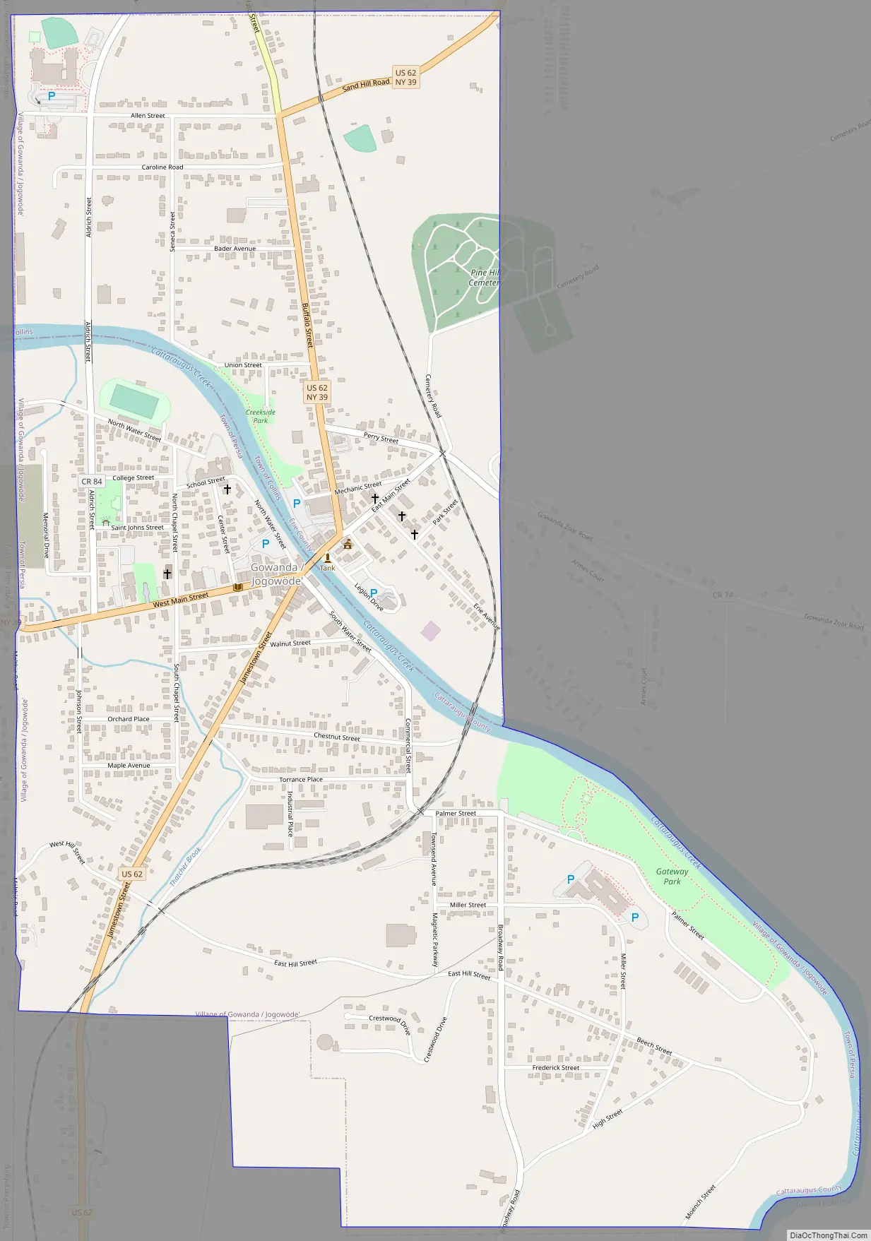
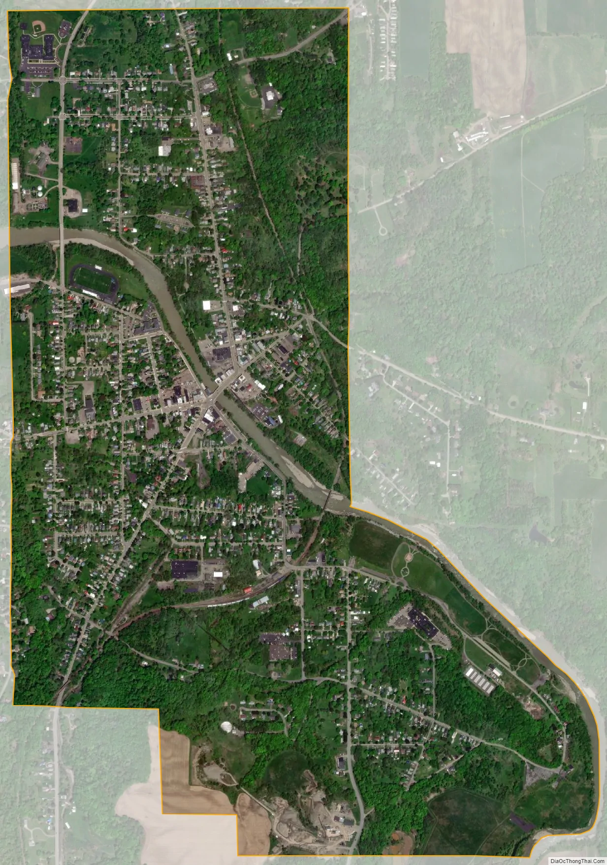
Gowanda city Satellite Map
Geography
Gowanda is located at 42°27′48″N 78°56′11″W / 42.46333°N 78.93639°W / 42.46333; -78.93639 (42.463197, -78.936350).
According to the United States Census Bureau, the village has a total area of 1.6 square miles (4.2 km), of which 0.02 square miles (0.04 km), or 1.00%, is covered by water.
The village is split by Cattaraugus Creek, the dividing boundary between Erie and Cattaraugus Counties, with the northern part of the village in Erie County and the southern in Cattaraugus.
The village is located on U.S. Route 62, County Road 4 (Broadway Road), NY Route 39, and NY Route 438. The NFTA provided bus service in the area until it abandoned the route in 2011. The Seneca Transit System began serving the village in 2013.
The New York and Lake Erie Railroad has a depot in Gowanda, from which it runs both freight and occasional passenger rail service.
The Cattaraugus Reservation is located to the northwest of the village.
See also
Map of New York State and its subdivision:- Albany
- Allegany
- Bronx
- Broome
- Cattaraugus
- Cayuga
- Chautauqua
- Chemung
- Chenango
- Clinton
- Columbia
- Cortland
- Delaware
- Dutchess
- Erie
- Essex
- Franklin
- Fulton
- Genesee
- Greene
- Hamilton
- Herkimer
- Jefferson
- Kings
- Lake Ontario
- Lewis
- Livingston
- Madison
- Monroe
- Montgomery
- Nassau
- New York
- Niagara
- Oneida
- Onondaga
- Ontario
- Orange
- Orleans
- Oswego
- Otsego
- Putnam
- Queens
- Rensselaer
- Richmond
- Rockland
- Saint Lawrence
- Saratoga
- Schenectady
- Schoharie
- Schuyler
- Seneca
- Steuben
- Suffolk
- Sullivan
- Tioga
- Tompkins
- Ulster
- Warren
- Washington
- Wayne
- Westchester
- Wyoming
- Yates
- Alabama
- Alaska
- Arizona
- Arkansas
- California
- Colorado
- Connecticut
- Delaware
- District of Columbia
- Florida
- Georgia
- Hawaii
- Idaho
- Illinois
- Indiana
- Iowa
- Kansas
- Kentucky
- Louisiana
- Maine
- Maryland
- Massachusetts
- Michigan
- Minnesota
- Mississippi
- Missouri
- Montana
- Nebraska
- Nevada
- New Hampshire
- New Jersey
- New Mexico
- New York
- North Carolina
- North Dakota
- Ohio
- Oklahoma
- Oregon
- Pennsylvania
- Rhode Island
- South Carolina
- South Dakota
- Tennessee
- Texas
- Utah
- Vermont
- Virginia
- Washington
- West Virginia
- Wisconsin
- Wyoming