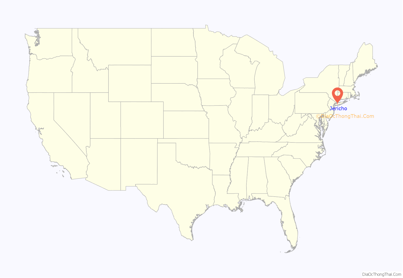
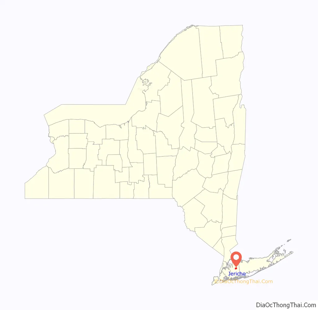
Jericho /dʒɛrɪkoʊ/ is a hamlet and census-designated place (CDP) in Nassau County, New York, United States, on the North Shore of Long Island, approximately 29 miles (47 km) east of Midtown Manhattan. Its population was 13,567 as of the U.S. 2010 Census.
The area is served by the Jericho Union Free and the Syosset Central School Districts, the boundaries of which differ somewhat from those of the hamlet. The boundaries of the Jericho Post Office vary from both the hamlet and the school district boundaries, including a portion of Jericho in the Westbury zip code and a portion of Syosset in the Jericho zip code.
| Name: | Jericho CDP |
|---|---|
| LSAD Code: | 57 |
| LSAD Description: | CDP (suffix) |
| State: | New York |
| County: | Nassau County |
| Elevation: | 197 ft (60 m) |
| Total Area: | 3.96 sq mi (10.26 km²) |
| Land Area: | 3.96 sq mi (10.26 km²) |
| Water Area: | 0.00 sq mi (0.00 km²) |
| Total Population: | 14,808 |
| Population Density: | 3,737.51/sq mi (1,443.09/km²) |
| ZIP code: | 11753, 11853, (small part of 11590) |
| Area code: | 516 |
| FIPS code: | 3638539 |
| GNISfeature ID: | 0954000 |
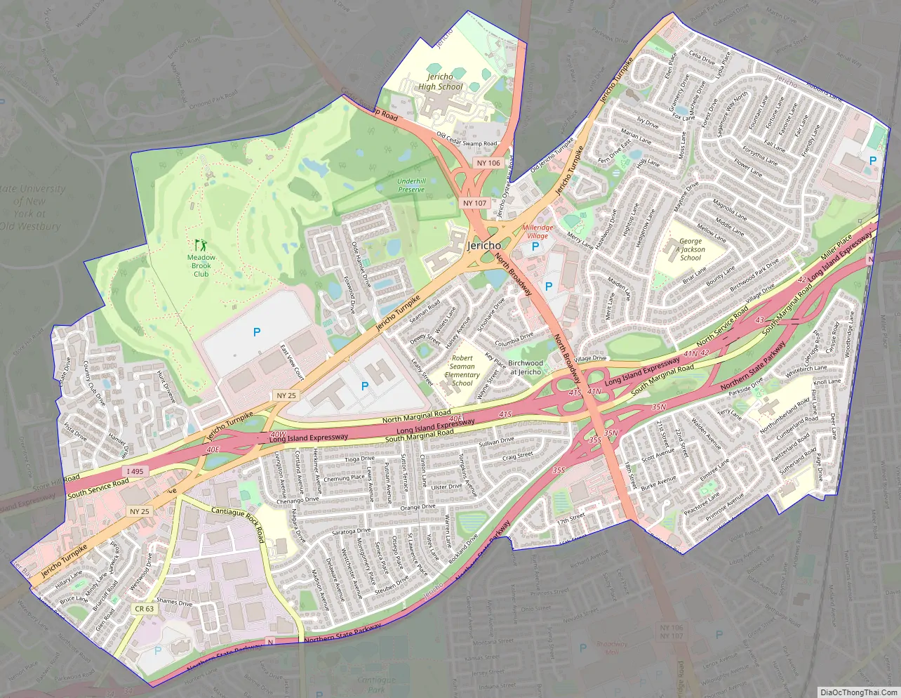
Online Interactive Map
Click on ![]() to view map in "full screen" mode.
to view map in "full screen" mode.
Jericho location map. Where is Jericho CDP?
History
Located mainly in the Town of Oyster Bay with a small part in the Town of North Hempstead, Jericho was part of the Robert Williams Plantation in 1648. The English families who settled in Jericho were, or soon became, Quakers, members of the Society of Friends. Many fled from persecution in England and in the New England Colonies. They sought a peaceful existence as farmers. The name of the area was changed in 1692 from Lusum to Jericho after the town in the Middle East near the Jordan River mentioned in the Bible as part of the Promised Land.
Elias Hicks married Jemima Seaman in 1771 and moved to her family’s farm in Jericho, where he soon became a noted preacher of Quaker doctrine. All the Quakers suffered during the British occupation of Long Island in the Revolutionary War. The practice was to quarter troops in homes of residents, who had to provide room and board for them. The Quakers continued to protest the entire concept of war itself. After the war, peace returned to Jericho, and the neat farms and businesses began to prosper. A Friends Meeting house was built in 1788 in Jericho that is still used in the 21st century. A Quaker school was built in 1793, the Charity Society of Jericho and Westbury in 1794, and slavery was abolished in 1817, with Hicks’ help.
A post office was established in 1802, a cider mill in the mid-19th century, the first public elementary school in 1905, known as the Cedar Swamp School. Improvements to infrastructure were made with the founding of the Jericho Water District in 1923. As the population increased, a new elementary school was built in 1953 (Robert Seaman School), and a Volunteer Fire Department established in 1938. The population kept increasing until the last elementary schools in Jericho were built, the George A. Jackson Elementary School in 1957, the now closed Robert Williams School in 1961 and the Cantiague School in 1963. When the Village of Muttontown was incorporated, the cider mill was within the village limits. Because most Gold Coast villages wanted to remain business free areas, many do not have their own post offices or ZIP Codes. Therefore, Jericho Post Office which serves this area of Muttontown is displayed as the official USPS mailing address and leads to the misconception that the cider mill is in Jericho.
After World War II, in the 1950s Phebe Underhill Seaman sold a large piece of her land to real estate developers. This property was developed for new suburban housing. The water tower was erected in 1952. In 1958 the NY Department of Transportation demolished “Old Jericho” to widen Broadway, Routes 106/107, and to put in a cloverleaf access to Jericho Turnpike. New grade schools and a high school were added to the community along with a shopping center, a new post office, new fire department and a public library.
Also in Jericho is the New York Community Bank Theatre, originally established in 1956 as the Westbury Music Fair. The main entrance to SUNY Old Westbury is located in Jericho.
Jericho Road Map
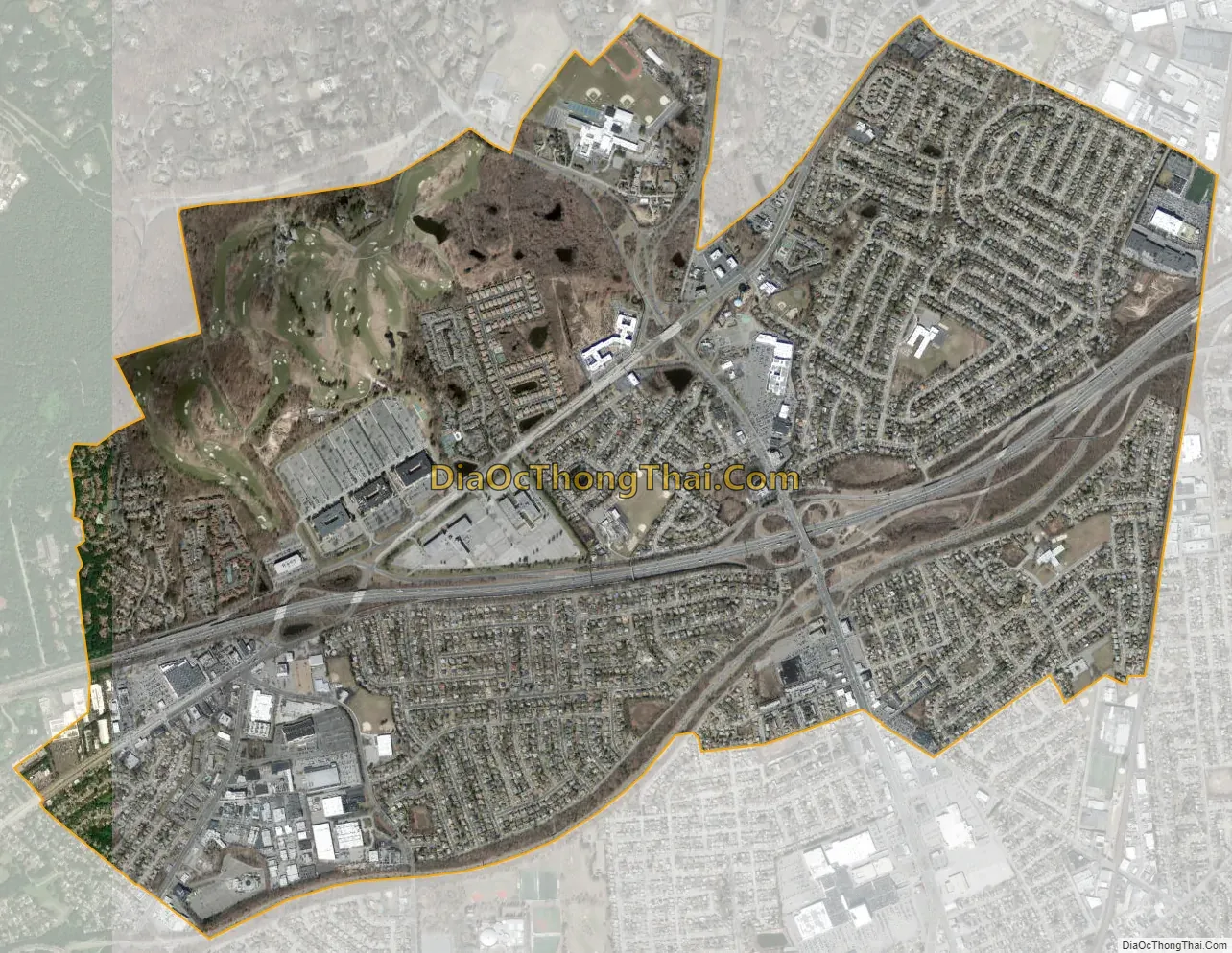
Jericho city Satellite Map
Geography
Jericho is located at 40°47′12″N 73°32′12″W / 40.786544°N 73.536757°W / 40.786544; -73.536757.
According to the United States Census Bureau, the CDP has a total area of 4.1 square miles (11 km), all land. It has a hot-summer humid continental climate (Dfa) and average monthly temperatures range from 30.9° F in January to 74.7° F in July. [1] The local hardiness zone is 7a.
It is served by the Long Island Expressway and the Long Island Rail Road, via the nearby Westbury, Hicksville, and Syosset train stations.
There is another Jericho in New York, located in the extreme Northeast corner of the state, in the Town of Altona, County of Clinton. It lies primarily along the Rand Hill Road.
See also
Map of New York State and its subdivision:- Albany
- Allegany
- Bronx
- Broome
- Cattaraugus
- Cayuga
- Chautauqua
- Chemung
- Chenango
- Clinton
- Columbia
- Cortland
- Delaware
- Dutchess
- Erie
- Essex
- Franklin
- Fulton
- Genesee
- Greene
- Hamilton
- Herkimer
- Jefferson
- Kings
- Lake Ontario
- Lewis
- Livingston
- Madison
- Monroe
- Montgomery
- Nassau
- New York
- Niagara
- Oneida
- Onondaga
- Ontario
- Orange
- Orleans
- Oswego
- Otsego
- Putnam
- Queens
- Rensselaer
- Richmond
- Rockland
- Saint Lawrence
- Saratoga
- Schenectady
- Schoharie
- Schuyler
- Seneca
- Steuben
- Suffolk
- Sullivan
- Tioga
- Tompkins
- Ulster
- Warren
- Washington
- Wayne
- Westchester
- Wyoming
- Yates
- Alabama
- Alaska
- Arizona
- Arkansas
- California
- Colorado
- Connecticut
- Delaware
- District of Columbia
- Florida
- Georgia
- Hawaii
- Idaho
- Illinois
- Indiana
- Iowa
- Kansas
- Kentucky
- Louisiana
- Maine
- Maryland
- Massachusetts
- Michigan
- Minnesota
- Mississippi
- Missouri
- Montana
- Nebraska
- Nevada
- New Hampshire
- New Jersey
- New Mexico
- New York
- North Carolina
- North Dakota
- Ohio
- Oklahoma
- Oregon
- Pennsylvania
- Rhode Island
- South Carolina
- South Dakota
- Tennessee
- Texas
- Utah
- Vermont
- Virginia
- Washington
- West Virginia
- Wisconsin
- Wyoming


