Southampton is a village in the Town of Southampton in Suffolk County, on the South Fork of Long Island, in New York, United States. The population was 3,109 at the 2010 census.
The Incorporated Village of Southampton serves as the Town Seat of the Town of Southampton, and is the oldest and largest of communities in the summer colony known as The Hamptons.
| Name: | Southampton village |
|---|---|
| LSAD Code: | 47 |
| LSAD Description: | village (suffix) |
| State: | New York |
| County: | Suffolk County |
| Elevation: | 26 ft (8 m) |
| Total Area: | 7.43 sq mi (19.24 km²) |
| Land Area: | 6.52 sq mi (16.88 km²) |
| Water Area: | 0.91 sq mi (2.36 km²) |
| Total Population: | 4,550 |
| Population Density: | 698.07/sq mi (269.52/km²) |
| Area code: | 631, 934 |
| FIPS code: | 3668462 |
| GNISfeature ID: | 0965893 |
| Website: | www.southamptonvillage.org |
Online Interactive Map
Click on ![]() to view map in "full screen" mode.
to view map in "full screen" mode.
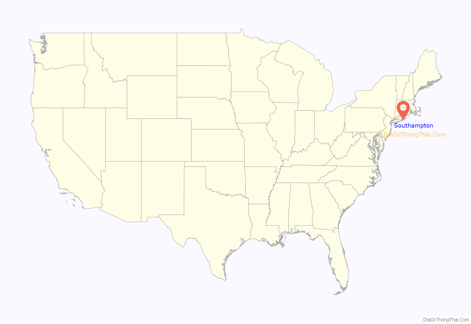
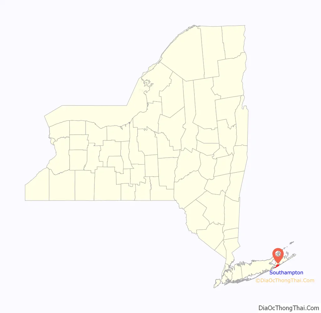
Southampton location map. Where is Southampton village?
History
Southampton, settled in 1640 and incorporated as a village in 1894, historically began with a small group of English settlers who set sail from Lynn, Massachusetts, and landed on June 12, 1640, at what is now known as Conscience Point. It is the oldest English settlement in the state of New York and is named after the English Earl of Southampton.
The Shinnecock tribe welcomed the arrival of the white settlers in 1640 and not only gave them land to live on, “Olde Towne”, but also shared with the settlers their knowledge of planting corn and fertilizing it with fish, growing crops, digging clams and scallops from nearby bays and trapping game. During the 18th and 19th centuries, fishing, farming (especially potatoes and the local sweet corn) and duck raising were the predominant industries.
The early settlers, with the help of a resident Shinnecock Indian guide, were led over an old woodland trail that is now North Sea Road to an ideal spot for their first settlement. There, at the head of what today is Old Town Pond, they constructed their first homes. The Shinnecock Reservation, established in 1701, is one of the oldest Native American reservations in the United States.
A property called the Halsey House was a homestead by pioneer Thomas Halsey in 1640. A rare “first period” house was built in 1660 when Main Street, in the pioneer hamlet of Southampton, was first laid out. Its owner, Thomas Halsey, was one of the original families who bought property from the Shinnecocks in 1640. It is one of the oldest English-type frame houses in the state.
Summer Colony
Theodore Gaillard Thomas, a New York City physician is regarded at the founder of the resort community, also termed the Summer Colony, of Southampton. He convinced a number of his wealthy clients about the beauty and potential restorative nature of the rural environment of Southampton. His efforts to develop this resort community began in 1863. He proved very successful at establishing what grew into a very prominent and affluent community of summer residents. Thomas and his friends ultimately established many of the leading institutions in Southampton including the St. Andrews Dune Church, the Shinnecock Golf Club, the Meadow Club, the Southampton Beach Club and The Parrish Art Museum (now located in Water Mill, NY).
Over time, several of the other villages and hamlets in what has become called the Hamptons increasingly became a haven for affluent summer season vacationers. Southampton Village, which hosted the earliest summer community of socially prominent residents and was arguably the center for upper class Americans, grew larger and faster than the others. Southampton has served as home to members of the Ford, Du Pont, Morgan, Atterbury, Woolworth and Eisenhower families.
21st century
Southampton Village is regarded as one of the premier summer resort areas in the country. The community of summer residents occupy the top echelon of American social, political and financial circles.
Accordingly, real estate is extremely expensive in the village. The Estate Section, which contains the majority of the homes for the very affluent residents, lies directly north of the Atlantic oceanfront and extends to Hill Street. Particular streets of note in the area include Ox Pasture Road, Halsey Neck Lane, Coopers Neck Lane, First Neck Lane and South Main Street. The homes around Lake Agawam, referred to by Thomas as “the very center of our Summer Colony” are particularly noteworthy for their architectural pedigree and historical provenance.
The oceanfront roads—Gin Lane and Meadow Lane—are generally the most expensive roads in the village. Meadow Lane in particular has been called Billionaire Lane, and cited as having among the most expensive residential real estate in the country.
Other areas in the village house the relatively large population of year-round residents. These neighborhoods extend from Hill Street northwards to Route 27, east to the hamlet of Water Mill, and west to the area of Tuckahoe in Southampton Town.
The Shinnecock Indian Reservation borders the village on its southwestern border. Shinnecock Hills Golf Club one of the oldest and most prestigious golf courses in the country, borders the village on its northwest corner. The Art Village, a summer art school started by William Merritt Chase and funded by early residents of the Southampton Summer Colony, is still in existence, though now it is entirely private residences; no arts education is conducted in the Art Village any more.
There are several working farms and agricultural preserves in the village. Most of those properties are located in the Estate Section, particularly in the Wickapogue Road Historic District.
Southampton Village boasts well regarded ocean beaches including Cooper’s Beach, which was voted #3 in a recent national poll. In 2010 it was listed as America’s top beach according to the annual list of the best American beaches compiled by Stephen Leatherman, AKA Dr. Beach.
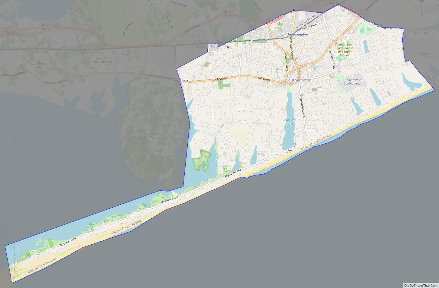
Southampton Road Map
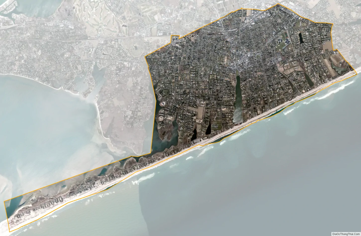
Southampton city Satellite Map
Geography
According to the United States Census Bureau, the village has a total area of 7.2 square miles (18.7 km), of which 6.4 square miles (16.6 km) is land and 0.81 square miles (2.1 km), or 11.03%, is water.
The village gained territory between the 1990 census and the 2000 census; the Southampton CDP that existed in 1990 was deleted and most of its territory went to two adjacent CDPs.
See also
Map of New York State and its subdivision:- Albany
- Allegany
- Bronx
- Broome
- Cattaraugus
- Cayuga
- Chautauqua
- Chemung
- Chenango
- Clinton
- Columbia
- Cortland
- Delaware
- Dutchess
- Erie
- Essex
- Franklin
- Fulton
- Genesee
- Greene
- Hamilton
- Herkimer
- Jefferson
- Kings
- Lake Ontario
- Lewis
- Livingston
- Madison
- Monroe
- Montgomery
- Nassau
- New York
- Niagara
- Oneida
- Onondaga
- Ontario
- Orange
- Orleans
- Oswego
- Otsego
- Putnam
- Queens
- Rensselaer
- Richmond
- Rockland
- Saint Lawrence
- Saratoga
- Schenectady
- Schoharie
- Schuyler
- Seneca
- Steuben
- Suffolk
- Sullivan
- Tioga
- Tompkins
- Ulster
- Warren
- Washington
- Wayne
- Westchester
- Wyoming
- Yates
- Alabama
- Alaska
- Arizona
- Arkansas
- California
- Colorado
- Connecticut
- Delaware
- District of Columbia
- Florida
- Georgia
- Hawaii
- Idaho
- Illinois
- Indiana
- Iowa
- Kansas
- Kentucky
- Louisiana
- Maine
- Maryland
- Massachusetts
- Michigan
- Minnesota
- Mississippi
- Missouri
- Montana
- Nebraska
- Nevada
- New Hampshire
- New Jersey
- New Mexico
- New York
- North Carolina
- North Dakota
- Ohio
- Oklahoma
- Oregon
- Pennsylvania
- Rhode Island
- South Carolina
- South Dakota
- Tennessee
- Texas
- Utah
- Vermont
- Virginia
- Washington
- West Virginia
- Wisconsin
- Wyoming


