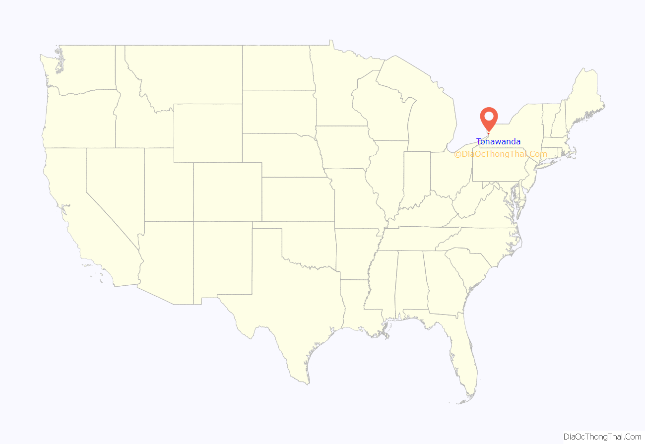
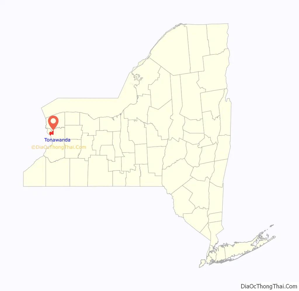
Tonawanda (formally City of Tonawanda) is a city in Erie County, New York, United States. The population was 15,129 at the 2020 census. It is at the northern edge of Erie County, south across the Erie Canal (Tonawanda Creek) from North Tonawanda, east of Grand Island, and north of Buffalo. It is part of the Buffalo-Niagara Falls metropolitan area.
| Name: | Tonawanda CDP |
|---|---|
| LSAD Code: | 57 |
| LSAD Description: | CDP (suffix) |
| State: | New York |
| County: | Erie County |
| Elevation: | 571 ft (174 m) |
| Total Area: | 4.09 sq mi (10.60 km²) |
| Land Area: | 3.80 sq mi (9.85 km²) |
| Water Area: | 0.29 sq mi (0.75 km²) |
| Total Population: | 15,129 |
| Population Density: | 3,978.18/sq mi (1,535.87/km²) |
| ZIP code: | 14150 |
| Area code: | 716 |
| FIPS code: | 3674183 |
| GNISfeature ID: | 0979550 |
Online Interactive Map
Click on ![]() to view map in "full screen" mode.
to view map in "full screen" mode.
Tonawanda location map. Where is Tonawanda CDP?
History
The city’s name is from the word Tahnawá•teh in Tuscarora meaning “confluent stream”
Post-Revolutionary War white settlement at Tonawanda began with Henry Anguish, who built a log home in 1808. He added to the hamlet in 1811 with a tavern, both on the south side of Tonawanda Creek where it empties into the Niagara River. The hamlet grew slowly until the opening of the Erie Canal, completed in the course of the creek in 1825. The Town of Tonawanda was incorporated in 1836. The Erie Canal and the railroads that soon followed it provided economic opportunity. By the end of the 19th century, both sides of the canal were devoted to businesses as part of a leading lumber processing center. In the mid-19th century, the business center of Tonawanda was incorporated as a village within the town. The village united in a corporation with North Tonawanda across the canal. This corporation fell apart, and in 1904 the village was incorporated as the City of Tonawanda.
On September 26, 1898, a tornado struck the City of Tonawanda. After crossing over the river from Grand Island, the tornado damaged the old Murray School as well as several homes along Franklin and Kohler streets. Its worst havoc was wreaked along Fuller Avenue, where a dozen homes were severely damaged, several being leveled to the ground. No one was killed by the fierce storm, but there were numerous injuries.
Goose Island
From the mid-19th century to the early 20th century, a section of Tonawanda was known as Goose Island. Goose Island was a man-made island in the Niagara River formed by the Erie Canal. Goose Island was a triangular piece of land bordered on one side by the Niagara River, on the second side by the Tonawanda Creek, and on the third by the Erie Canal. It was then famous with seamen the world over as the terminus of the Erie Canal and for the Goose Island girls. The Goose Island Section of Tonawanda had many cheap boarding houses, cheap hotels, bars, and houses of ill repute. Canalers often wintered over on Goose Island. Goose Island was known as a bad section of Tonawanda, with drunkenness, brawling, and bawdy displays being commonplace. The gentrification of Goose Island began with the decline of the lumbering port business in Tonawanda and the building of a boxboard mill there on the island. Then the canal was motorized, eliminating mules and many canal men. Next the section of the canal from Tonawanda to Buffalo was abandoned in 1918. That section of the canal was filled in and Goose Island was no longer an island. The establishments in the Goose Island section of Tonawanda came under community pressure in the 1920s and 1930s and were closed, with more of the land there being given over to the boxboard mill. In the 1970s the boxboard mill closed and was razed along with many remaining Goose Island structures. Goose Island street names Tonawanda, First, Clay and Chestnut disappeared. At the turn of the millennium waterfront dwellings were built along the Niagara River, completing the gentrification of this area.
Spaulding Fibre
Spaulding Fibre became a manufacturer of leatherboard (made from leather scraps and wood pulp), transformer board, vulcanized fibre, bakelite (under the trade name Spauldite) and Filawound (fiberglass) tube. Operating in Tonawanda from 1911 to 1992, it became the major employer in the city. The company was founded in 1873 with a leatherboard mill by Jonas Spaulding and his brother Waldo in Townsend Harbor, Massachusetts. They did business as The Spaulding Brothers Company. Jonas Spaulding had three sons: Leon C., Huntley N. and Rolland H.
With industry expanding, Jonas established leatherboard mills at Milton and North Rochester, New Hampshire, in part to allow his sons to join him in the business. The New Hampshire mills operated under the name J. Spaulding and Sons. After Jonas Spaulding’s death in 1900, his sons (by then living in New Hampshire, where they had corporate headquarters at Rochester) continued to operate these mills successfully. They brought the Townsend Harbor mill under the J. Spaulding and Sons banner in 1902.
With continued success, the three Spaulding brothers added a vulcanized fibre operation in Tonawanda, New York in 1911. They added a fourth leatherboard mill in Milton (second in this community) in 1913. The mayor of Tonawanda, Charles Zuckmaier, had solicited the Spaulding brothers’ business in Tonawanda. A ground-breaking ceremony was held on July 17, 1911, for the new plant, a $600,000 investment by J. Spaulding and Sons. Operations began on April 1, 1912, with 40 employees. The daily capacity of the plant at the time was five tons of fibre sheeting and one ton of fibre tubing.
Around 1924, the sons changed the name of the company to the Spaulding Fibre Company. In the 1930s, they added a second product at the Tonawanda plant: Spauldite, a “me too” phenol formaldehyde resin material made to compete with Bakelite. The trademark now owned by Spaulding Composites can be applied to laminates made with other natural or synthetic resins as well.
After Huntley Spaulding, the last of the three brothers, died in November 1955, the Spaulding Fibre Company became part of a charitable trust previously set up by Huntley and his only sister, Marion S. Potter. The trust was created to disburse their remaining wealth within 15 years of the death of the last sibling. Marion S. Potter died on September 27, 1957.
The company in Tonawanda flourished under foremen, superintendents and workers from the local blue collar workforce. It also attracted new residents who came for the jobs. One was Richard Spencer, who left the oil fields of Bradford, Pennsylvania, to be a superintendent for two decades. He managed through several labor strikes and periods of economic unrest for the company.
In 1956, the Tonawanda plant completed an expansion that doubled the paper mill and the vulcanized fibre-making capacity of the plant. In addition, after the death of Huntley Spaulding, corporate offices relocated to Wheeler Street from Rochester, New Hampshire. In the 1960s, the Tonawanda plant added a third product line, Filawound (fiberglass) tubing.
The 50th anniversary of the Wheeler Street Plant in 1961 was marked by a special 22-page section in the Tonawanda News. The Wheeler Street Plant reportedly covered 610,000 square feet (57,000 m), employed 1,500 workers, and had an annual payroll of $9,000,000. The company paid $153,818 in city taxes that year and was Tonawanda’s largest taxpayer. The plant was nearing its peak, but there was more expansion to come.
In 1966, the charitable trust sold the Spaulding Fibre Company to Monogram Industries. The Tonawanda plant began a slow decline during a period of industrial restructuring and product and manufacturing changes. In 1984, Monogram Industries sold the Spaulding Fibre Company to Nortek. In 1988, Nortek changed the company name to Spaulding Composites. Spaulding Composites closed the Tonawanda plant on August 24, 1992.
By the time the plant closed, employment had declined to 300. Since the closure of the Tonawanda plant, Spaulding Composites twice filed for bankruptcy. The plant site had a footprint of 860,000 square feet (80,000 m). It fell into disrepair and, because of the wastes of the industrial processes, was classified as a brown field site under environmental regulations.
In 2006, the Erie County Development Agency contracted for demolition of the derelict facilities. It was punctuated by the felling of the 250-foot (76 m)-tall smoke stack that dominated the site. (This event is documented with a handful of videos on YouTube.) Cleanup of the site was declared complete in August 2010.
Historic sites
The following are historic sites in Tonawanda of such significance as to be listed on the National Register of Historic Places:
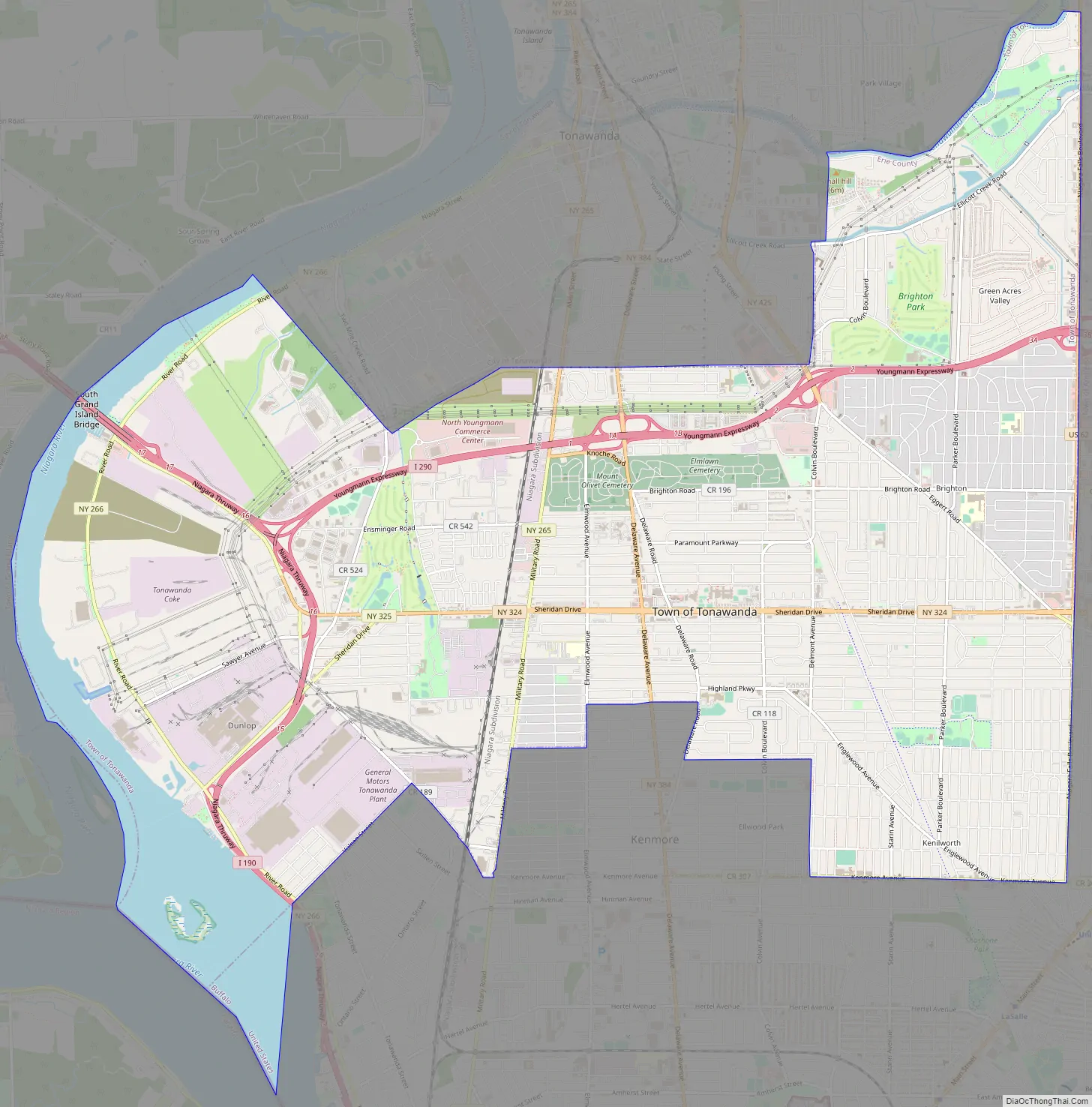
Tonawanda Road Map
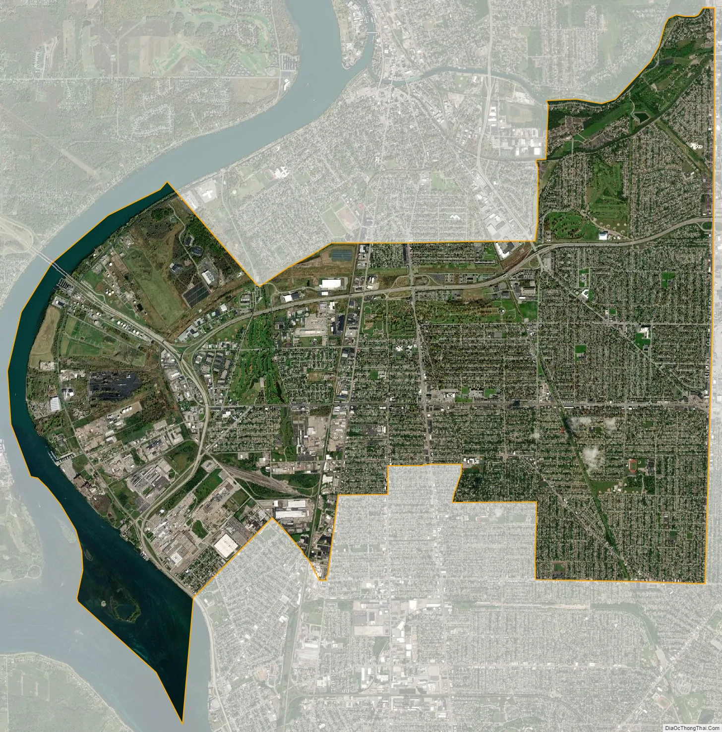
Tonawanda city Satellite Map
Geography
Tonawanda is at 43°0′40″N 78°52′38″W / 43.01111°N 78.87722°W / 43.01111; -78.87722 (43.01119, -78.877399).
According to the United States Census Bureau, the city has an area of 4.1 square miles (10.6 km), of which 3.8 square miles (9.8 km) is land and 0.3 square miles (0.8 km), or 7.34%, is water.
Adjacent cities and towns
Niagara County, City of North Tonawanda – north
Town of Tonawanda – west/south/east
Town of Grand Island across the Niagara River – northwest
Neighborhoods and locations
- Gastown – A neighborhood in the northeast corner of Tonawanda, bordering the Erie Canal. Its name comes from the Gas Light Co., which was built on Long’s Point, home of the historical Long’s Homestead.
- “The Hill” (aka “Riverview”) – A region centered around Tonawanda High School, so named because of its slightly elevated topography when compared with the rest of the relatively flat city. It is also known as Clay Hill as it was formed by a terminal glacial moraine that deposited the clay that forms the hill. The area near the high school was the site of popular clay tennis courts.
- Millstream – A neighborhood on the city’s eastern side. It is named for a stream that flowed through the area, but has since been mostly channelled underground.
- Ives – a local skatepark, ice hockey rink, soccer field, and tennis court in the middle of Tonawanda. Starting out as a small blue kiddy pool, it was remodelled to become a skatepark and other things.
- Delawanda – an older residential neighborhood north of Canton St. and east of Delaware St.
The City of Tonawanda is called by many of its residents the “C.O.T.”, meaning the “City” rather than “Town” of Tonawanda.
Major highways
- New York State Route 265 (Main St., Seymour St., River Rd.) North-South Roadway from the Tonawanda town line (south) north through the city and over the Erie Canal/Tonawanda Creek into North Tonawanda.
- New York State Route 266 (Niagara St.), East-West Roadway from in the city that parallels the Niagara River from the Tonawanda town line (west) through the city to its east end at Seymour St./River Rd. (NY 265) intersection in the city.
- New York State Route 384 (Delaware St.), North-South Road from the Tonawanda town line at the south, north through the city and to North Tonawanda by the way of Main St. across the Canal.
- New York State Route 425 (Twin Cities Memorial Highway.) North-South Highway through the east part of town from its south end at Interstate 290 north to North Tonawanda once it crosses over the Canal. (This is a major transportation route for traffic to-and-from North Tonawanda and beyond).
See also
Map of New York State and its subdivision:- Albany
- Allegany
- Bronx
- Broome
- Cattaraugus
- Cayuga
- Chautauqua
- Chemung
- Chenango
- Clinton
- Columbia
- Cortland
- Delaware
- Dutchess
- Erie
- Essex
- Franklin
- Fulton
- Genesee
- Greene
- Hamilton
- Herkimer
- Jefferson
- Kings
- Lake Ontario
- Lewis
- Livingston
- Madison
- Monroe
- Montgomery
- Nassau
- New York
- Niagara
- Oneida
- Onondaga
- Ontario
- Orange
- Orleans
- Oswego
- Otsego
- Putnam
- Queens
- Rensselaer
- Richmond
- Rockland
- Saint Lawrence
- Saratoga
- Schenectady
- Schoharie
- Schuyler
- Seneca
- Steuben
- Suffolk
- Sullivan
- Tioga
- Tompkins
- Ulster
- Warren
- Washington
- Wayne
- Westchester
- Wyoming
- Yates
- Alabama
- Alaska
- Arizona
- Arkansas
- California
- Colorado
- Connecticut
- Delaware
- District of Columbia
- Florida
- Georgia
- Hawaii
- Idaho
- Illinois
- Indiana
- Iowa
- Kansas
- Kentucky
- Louisiana
- Maine
- Maryland
- Massachusetts
- Michigan
- Minnesota
- Mississippi
- Missouri
- Montana
- Nebraska
- Nevada
- New Hampshire
- New Jersey
- New Mexico
- New York
- North Carolina
- North Dakota
- Ohio
- Oklahoma
- Oregon
- Pennsylvania
- Rhode Island
- South Carolina
- South Dakota
- Tennessee
- Texas
- Utah
- Vermont
- Virginia
- Washington
- West Virginia
- Wisconsin
- Wyoming