Wappingers Falls is a village in the towns of Poughkeepsie and Wappinger, in Dutchess County, New York, United States. As of the 2010 census it had a population of 5,522. The community was named for the cascade in Wappinger Creek. The Wappingers Falls post office covers areas in the towns of Wappinger, Poughkeepsie, Fishkill, East Fishkill, and LaGrange. This can result in some confusion when residents of the outlying towns, who do not live in the village, give their address as “Wappingers Falls”.
Grinnell Library, located in the village, is the sixth-oldest library in the state.
| Name: | Wappingers Falls village |
|---|---|
| LSAD Code: | 47 |
| LSAD Description: | village (suffix) |
| State: | New York |
| County: | Dutchess County |
| Incorporated: | 1871 |
| Elevation: | 154 ft (47 m) |
| Total Area: | 1.20 sq mi (3.11 km²) |
| Land Area: | 1.12 sq mi (2.90 km²) |
| Water Area: | 0.08 sq mi (0.20 km²) |
| Total Population: | 6,103 |
| Population Density: | 5,444.25/sq mi (2,102.14/km²) |
| ZIP code: | 12590 |
| Area code: | 845 |
| FIPS code: | 3678168 |
| GNISfeature ID: | 0968775 |
| Website: | www.wappingersfallsny.gov |
Online Interactive Map
Click on ![]() to view map in "full screen" mode.
to view map in "full screen" mode.
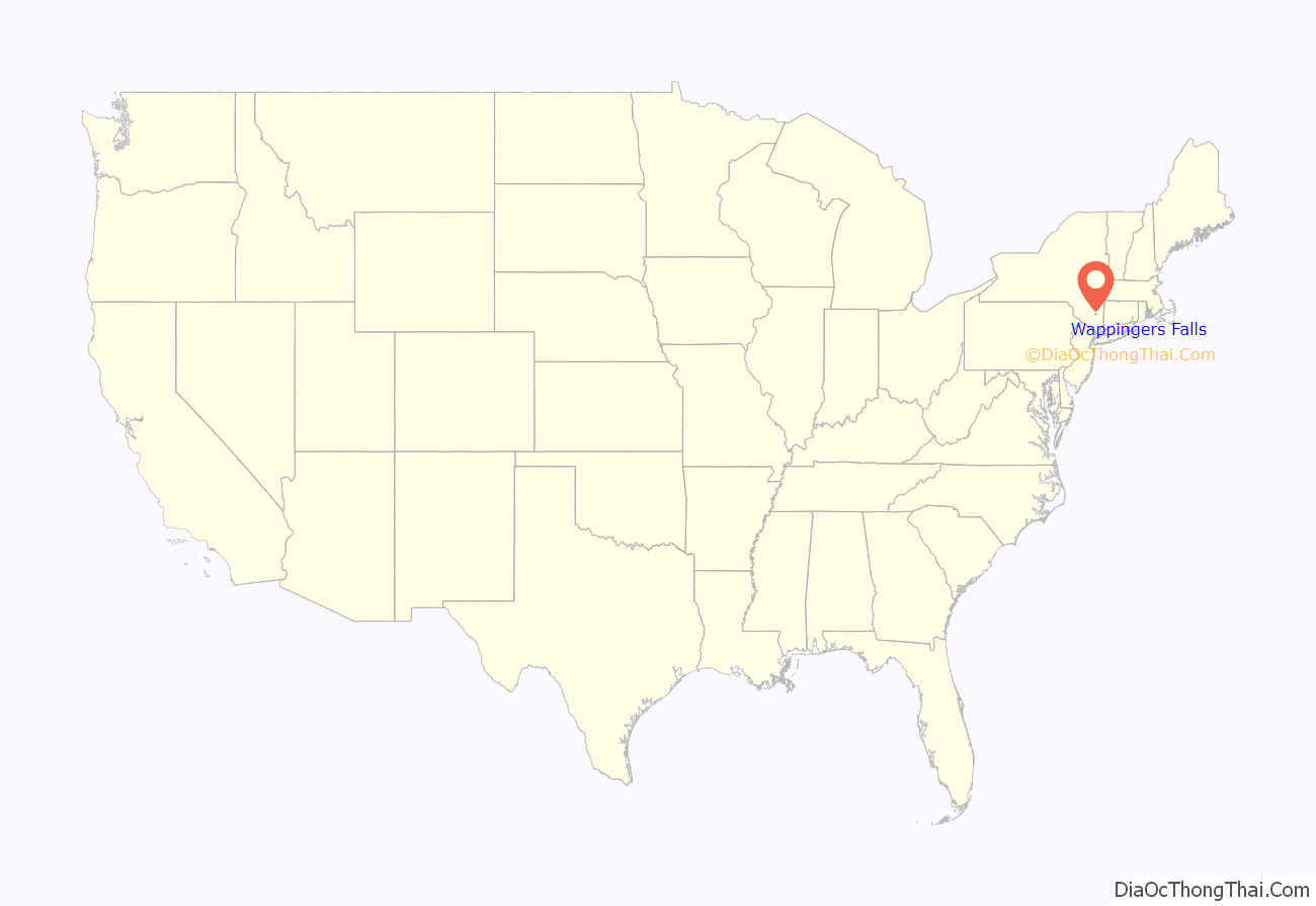
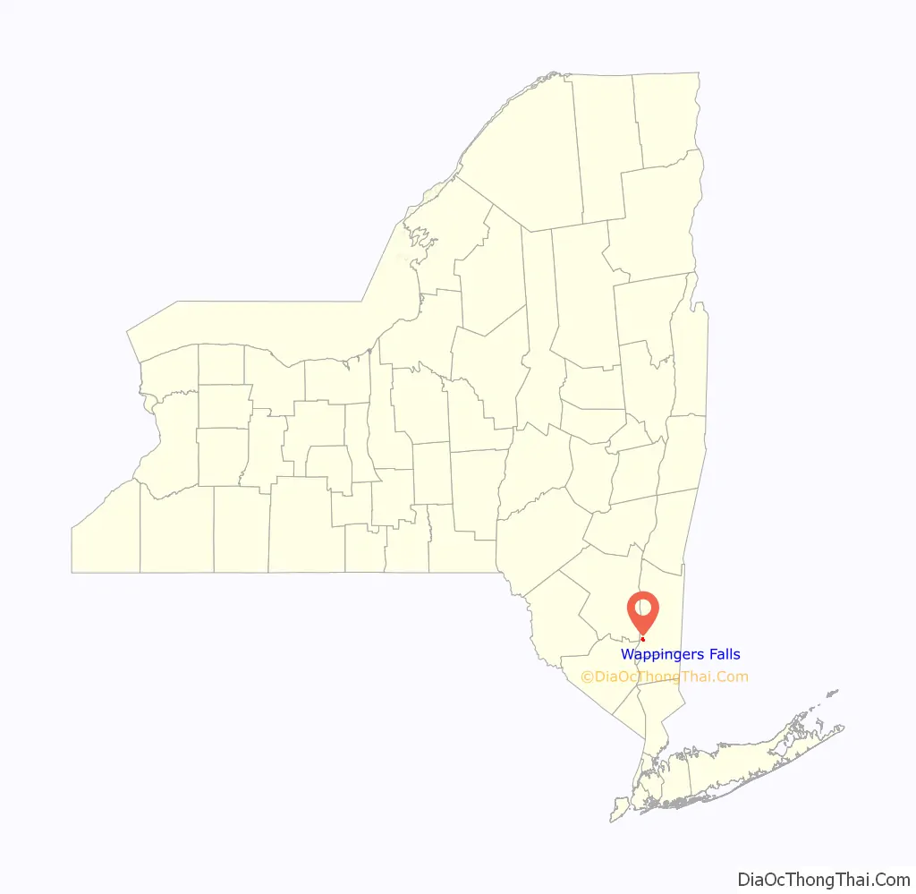
Wappingers Falls location map. Where is Wappingers Falls village?
History
The Wappinger were an Algonquian-speaking confederacy of Native Americans whose territory in the 17th century extended along the eastern bank of the Hudson River. Primarily based in what is now Dutchess County, their territory was bordered by Manhattan Island to the south, the Mahican territory bounded by the Roeliff Jansen Kill to the north, and extended east into parts of Connecticut. Wappinger means “easterner” in most Algonquian languages.
The area was part of the Rombout Patent. In 1741, two Dutchmen, Nicholas and Adolphus Brewer, purchased 750 acres (300 ha) of land around the falls and built the first stone house in the village near the present Mill Street. In 1742, the Brewers built a mill on the east side of Wappinger Creek. Nicholas Brewer built the Mesier Homestead, which he sold in 1777 to Matthew VanBenschoten, who, in turn, sold it to Peter Mesier Sr., a merchant from New York City.
In May 1777, soldiers and local residents attacked Peter Mesier’s house in Wappingers Falls, disputing the price of tea for sale in a small store inside his home. Mesier was a merchant from New York City and a Loyalist. The angry mob struck Mesier, beat his slaves, and drank wine stored in the cellar. They also took the tea and left a small amount of money behind.
The local waterfall was important for early industrial development. In 1819 a small cotton mill was built in the hollow created by the creek as it descends from Wappinger Lake to drain into the Hudson River. By 1856 it had become one of the largest printworks in the country. A fire that year destroyed the original buildings completely, but they were immediately rebuilt and continued in operation until 1931. The streets on the hillside opposite the mill are lined with frame houses, mostly duplexes, built by the mill for its workers. The two halves of the village are connected by an 1884 stone arch bridge that replaced earlier wooden structures.
The village of Wappingers Falls was incorporated in 1871 and included the adjacent community on the west side of the Wappinger Creek, by then called Channingville. The east side was known as Franklindale. In 1885 the Franklindale Cotton Mill, which employed about 130 people, was destroyed by fire. During President Grover Cleveland’s second administration, the Independent Comb Factory on the corner of Fulton and Prospect streets was forced to close. The repeal of the tariff made it impossible for the company to compete with German-made combs. In 1909, the Garner Print Works were sold and became the Dutchess Bleachery. The plant, which at times employed as many as 1,150 people, stopped printing calico but continued as a bleachery and dye works.
On June 3, 2017 downtown Wappingers Falls had a devastating structure fire that left more than 30 people displaced and six businesses temporarily closed. No one was injured during the fire, which spread through a strip of buildings in the East Main Street corridor on Saturday afternoon.
Channingville
That portion of the village lying north of the creek, in the town of Poughkeepsie, was originally known as “Ednam”. It later became known as Channingville (sometimes rendered “Chiningville”), which name is derived from the Channing family, who owned the farm on which it mostly lies.
The first merchant in this part of the village was a cooper, John Crilley, from Ireland by way of Glenham. In 1842 he built the first brick building erected on either side of the creek. By 1836, Ednam had about thirty dwellings and a cotton factory with 2,400 spindles and 90 looms, making 500,000 yards of cloth per annum.
J.J. O’Riley’s North American Hotel and Eagan’s Opera House (built in 1876 by John Eagan, with a seating capacity for five hundred people) were located here. The village’s first post office was established here in 1840. The post office bore the name of the creek.
The Bain Commercial Building is located at the corner of Church and West Main (NY 9D) streets. The Bain family is believed to have built the building in 1875, shortly after Channingville became part of the village. It was both their residence and their place of business. It is a late 19th-century brick building that was listed on the National Register of Historic Places in 1984.
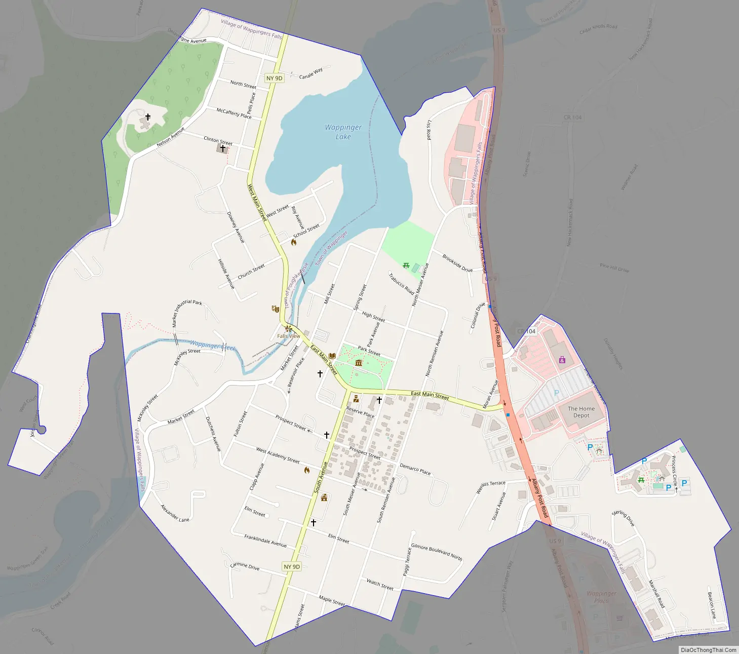
Wappingers Falls Road Map
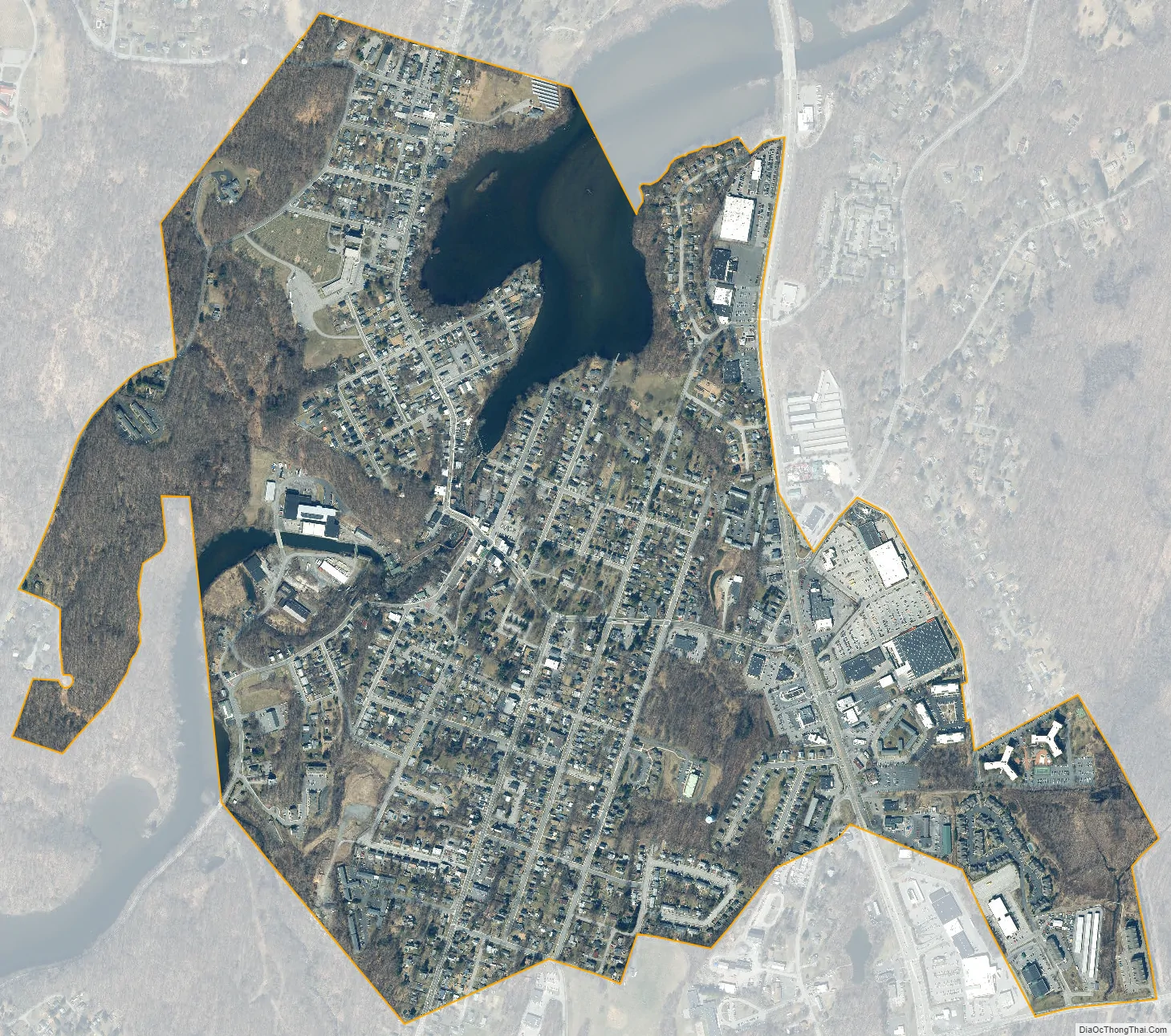
Wappingers Falls city Satellite Map
Geography
Wappingers Falls is situated at the head of navigation on Wappinger Creek, about 2 miles (3 km) above (northeast of) its confluence with the Hudson River. According to the United States Census Bureau, the village has a total area of 1.2 square miles (3.1 km), of which 1.1 square miles (2.9 km) is land and 0.1 square miles (0.2 km), or 6.45%, is water.
Wappinger Creek flows through the village. The Wappingers Falls post office serves both the village of Wappingers Falls and the town of Wappinger (as well as portions of Fishkill, East Fishkill, Poughkeepsie and LaGrange) under the ZIP code “Wappingers Falls, NY 12590”. US 9 passes through the village, as well as NY 9D.
See also
Map of New York State and its subdivision:- Albany
- Allegany
- Bronx
- Broome
- Cattaraugus
- Cayuga
- Chautauqua
- Chemung
- Chenango
- Clinton
- Columbia
- Cortland
- Delaware
- Dutchess
- Erie
- Essex
- Franklin
- Fulton
- Genesee
- Greene
- Hamilton
- Herkimer
- Jefferson
- Kings
- Lake Ontario
- Lewis
- Livingston
- Madison
- Monroe
- Montgomery
- Nassau
- New York
- Niagara
- Oneida
- Onondaga
- Ontario
- Orange
- Orleans
- Oswego
- Otsego
- Putnam
- Queens
- Rensselaer
- Richmond
- Rockland
- Saint Lawrence
- Saratoga
- Schenectady
- Schoharie
- Schuyler
- Seneca
- Steuben
- Suffolk
- Sullivan
- Tioga
- Tompkins
- Ulster
- Warren
- Washington
- Wayne
- Westchester
- Wyoming
- Yates
- Alabama
- Alaska
- Arizona
- Arkansas
- California
- Colorado
- Connecticut
- Delaware
- District of Columbia
- Florida
- Georgia
- Hawaii
- Idaho
- Illinois
- Indiana
- Iowa
- Kansas
- Kentucky
- Louisiana
- Maine
- Maryland
- Massachusetts
- Michigan
- Minnesota
- Mississippi
- Missouri
- Montana
- Nebraska
- Nevada
- New Hampshire
- New Jersey
- New Mexico
- New York
- North Carolina
- North Dakota
- Ohio
- Oklahoma
- Oregon
- Pennsylvania
- Rhode Island
- South Carolina
- South Dakota
- Tennessee
- Texas
- Utah
- Vermont
- Virginia
- Washington
- West Virginia
- Wisconsin
- Wyoming


