Oberlin is a city in Lorain County, Ohio, United States. It is located about 31 miles (50 km) southwest of Cleveland within the Cleveland metropolitan area. The population was 8,555 at the 2020 census. Oberlin is the home of Oberlin College, a liberal arts college and music conservatory with approximately 3,000 students.
The town is the birthplace of the Anti-Saloon League and the Hall-Héroult process, the process of reducing aluminum from its fluoride salts by electrolysis, which made industrial production of aluminum possible.
| Name: | Oberlin city |
|---|---|
| LSAD Code: | 25 |
| LSAD Description: | city (suffix) |
| State: | Ohio |
| County: | Lorain County |
| Elevation: | 814 ft (248 m) |
| Total Area: | 4.96 sq mi (12.85 km²) |
| Land Area: | 4.92 sq mi (12.75 km²) |
| Water Area: | 0.04 sq mi (0.10 km²) |
| Total Population: | 8,555 |
| Population Density: | 1,737.06/sq mi (670.75/km²) |
| ZIP code: | 44074 |
| Area code: | 440 |
| FIPS code: | 3957834 |
| GNISfeature ID: | 1049034 |
| Website: | http://www.cityofoberlin.com/ |
Online Interactive Map
Click on ![]() to view map in "full screen" mode.
to view map in "full screen" mode.
Oberlin location map. Where is Oberlin city?
History
Oberlin was founded in 1833 by two Presbyterian ministers, John Jay Shipherd and Philo P. Stewart. The pair had become friends while spending the summer of 1832 together in nearby Elyria and discovered a shared dissatisfaction with what they saw as the lack of strong Christian morals among the settlers of the American West. Their proposed solution was to create a religious community that would more closely adhere to Biblical commandments, along with a school for training Christian missionaries who would eventually spread throughout the American frontier. The two decided to name their community after Johann Friedrich Oberlin (1740–1826), an Alsatian minister whose pedagogical achievements in a poor and remote area had greatly impressed and inspired them.
Shipherd and Stewart rode south from Elyria into the forests that then covered the northern part of Ohio in search of a suitable location for their community. After a journey of approximately eight miles, they stopped to rest and pray in the shade of an elm tree along the forest, and agreed that this would be a good place to start their community.
Shipherd traveled back east and convinced the owner of the land to donate 500 acres (2.0 km) of land for the school, and he purchased an additional 5,000 acres (20 km) for the town, at the cost of $1.50 per acre ($371/km).
In 1834 a charter for the new Oberlin Collegiate Institute was obtained from the legislature of Ohio, and the institute adopted as its motto “Learning and Labor.” The same year saw a freshman class of four students. In those days the words were taken quite literally: tuition at Oberlin was free, but students were expected to contribute by helping to build and sustain the community. This attracted a number of bright young people who would otherwise not have been able to afford tuition. The motto remains to this day.
During the mid-1800s African Americans, predominantly free people of color and runaway slaves, settled in the area.
In Oberlin’s earliest years, transportation (especially for students) depended heavily on weather-dependent Lake Erie transportation routes; the nearest railroad passed through Wellington, and travellers were forced to rely on stagecoaches between that village and Oberlin. This situation changed in 1852 when the Toledo, Norwalk, and Cleveland Railroad opened a stop in Oberlin along its Grafton line. Fifteen years later, the Lake Shore and Michigan Southern Railway opened a new rail station along this line; no longer used for rail transportation, the depot has been converted for community use and sits at the center of a park.
On June 28, 1924, the worst flood in Oberlin history occurred on the same day that a tornado killed 62 people in Lorain. Afterward, the water was so deep that children swam in Tappan Square. Damage was caused to all of downtown Oberlin.
One of Oberlin’s largest employers was the Federal Aviation Administration, which houses the Cleveland Air Route Traffic Control Center overseeing the airspace of six states and a small part of Canada.
Abolitionism
Oberlin was not founded as an abolitionist town. Its status changed with the enrollment in 1835 of the Lane Rebels, a loose group of several dozen students coordinated by abolitionist Theodore Weld. They had withdrawn en masse from the new Lane Theological Seminary of Cincinnati because of its treatment of the Black community and opposition to abolition of slavery. Cincinnati, on the Ohio River, was not a city where free blacks were safe, nor did Cincinnati welcome fugitives.
By chance, this group encountered Shipherd, who was travelling around Ohio looking for students for his new Collegiate Institute. The group agreed to come to Oberlin, but on condition that Asa Mahan, who had resigned as a Lane trustee, come as president, and that Oberlin treat Black and white students equally, something no college in the United States did at the time. The trustees, although reluctantly, agreed to these conditions. The first Black enrolees, James Bradley and the brothers Gideon Quarles and Charles Henry Langston, did not enroll in Oberlin but in an affiliated school, the Sheffield Manual Labor Institute. (Their younger brother John Mercer Langston, who in 1888 became the first black elected to the United States Congress from Virginia, also studied at Oberlin.)
By the middle of the 19th century, Oberlin had become a major focus of the abolitionist movement in the United States. Escaped enslaved people were relatively safe there. Thousands of escaped enslaved people crossing the Ohio River from Kentucky came through Oberlin—some to stay in the area, but most as a way-station to recover on their way to Lake Erie, where they found transportation across the lake to the safety of Canada West (Ontario).
The town of Oberlin, then, was an active “station” on the Underground Railroad. Fugitive enslaved people were assisted by a new Ohio law that allowed them to apply for a writ of habeas corpus, which protected them from extradition back to the Southern states from which they had escaped. In 1858, a newly elected Democratic state legislature repealed this law, making fugitives around Oberlin vulnerable to enforcement of the Federal Fugitive Slave Law, which allowed Southern slave-catchers to target and extradite them back to the South.
This situation came to a head with the Oberlin-Wellington Rescue, a pivotal event described in Nat Brandt’s book The Town That Started the Civil War. On September 13, 1858, a fugitive named John Price was captured by federal officials and held in neighboring Wellington, Ohio. A large group of Oberlin residents, consisting of both white and black townspeople, students, and faculty, set out for Wellington to release Price from captivity.
The men took Price back from the arresting US Marshal, and eventually smuggled him to Canada, but the authorities were not content to let the matter rest. United States President James Buchanan personally requested prosecution of the group (now referred to by sympathetic parties as “the Rescuers”), and 37 of them were indicted. Twelve of those were formerly enslaved people, including Charles H. Langston. State authorities arrested the US Marshal who had captured Price. In negotiation, the state agreed to free the arresters, and the federal officials agreed to free all but two of those indicted. Simeon M. Bushnell, a white man, and Charles H. Langston were both tried and convicted by an all-Democrat jury. Langston’s eloquent speech against slavery and injustice persuaded the judge to give them light sentences, with Langston receiving 20 days in jail and a fine of $100. They appealed to the Ohio Supreme Court for a writ of habeas corpus, but on May 30, 1859, their petition was denied.
Three formerly enslaved people—Lewis Sheridan Leary, Shields Green, and John Anthony Copeland, Jr.—participated in John Brown’s famous 1859 raid on Harpers Ferry. Leary died during the raid, and Green and Copeland were hanged after arrest and conviction. The bodies of Green and Copeland were used for dissection and anatomical study at the Winchester Medical College; the remains were discarded. Leary’s body was first thrown in an unmarked pit, along with the 7 of the 9 others killed during the raid; much later the bodies were disinterred and reburied at the John Brown Farm, next to his grave. (See John Brown’s raiders.)
The political ferment resulting from the Oberlin-Wellington Rescue led to a number of major protests throughout the northern part of Ohio, and an unprecedented boost to the anti-slavery Republican party in the 1860 state elections. The governor of Ohio wrote to the new Republican President Abraham Lincoln urging him to repeal the Fugitive Slave Law. Though in point of fact Lincoln declined this request, this decision did not prevent Southern states from seceding, and America was soon embroiled in the Civil War.
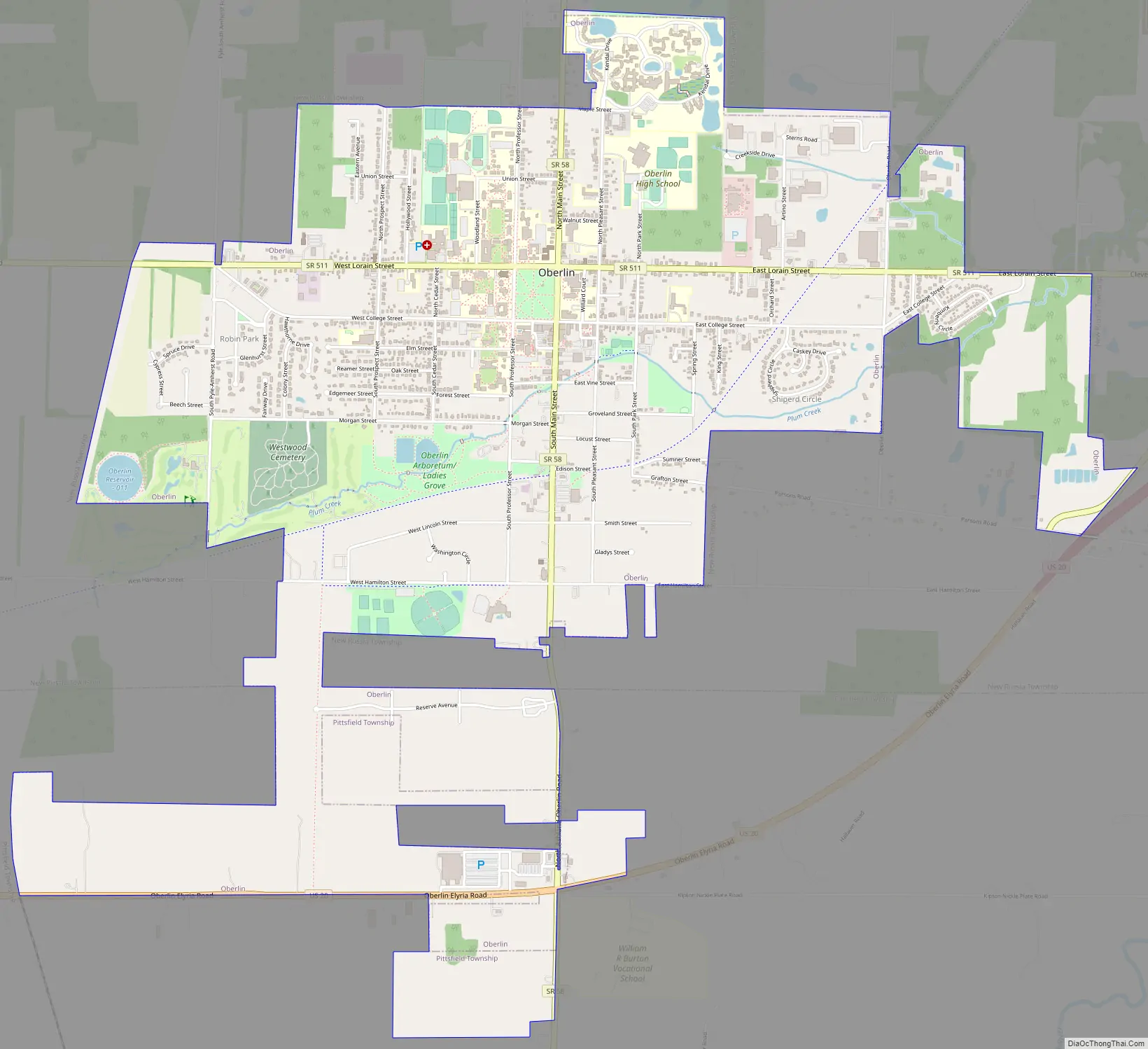
Oberlin Road Map
Oberlin city Satellite Map
Geography
According to the United States Census Bureau, the city has a total area of 4.96 square miles (12.85 km), of which, 4.92 square miles (12.74 km) is land and 0.04 square miles (0.10 km) is water.
Climate
Oberlin experiences a humid continental (Köppen Dfa) climate. Winters are cold, dry and often snowy. Summers are warm to very warm and sometimes hot. The city rests within the northern snowbelt of Ohio and is tempered by the Great Lakes.
See also
Map of Ohio State and its subdivision:- Adams
- Allen
- Ashland
- Ashtabula
- Athens
- Auglaize
- Belmont
- Brown
- Butler
- Carroll
- Champaign
- Clark
- Clermont
- Clinton
- Columbiana
- Coshocton
- Crawford
- Cuyahoga
- Darke
- Defiance
- Delaware
- Erie
- Fairfield
- Fayette
- Franklin
- Fulton
- Gallia
- Geauga
- Greene
- Guernsey
- Hamilton
- Hancock
- Hardin
- Harrison
- Henry
- Highland
- Hocking
- Holmes
- Huron
- Jackson
- Jefferson
- Knox
- Lake
- Lake Erie
- Lawrence
- Licking
- Logan
- Lorain
- Lucas
- Madison
- Mahoning
- Marion
- Medina
- Meigs
- Mercer
- Miami
- Monroe
- Montgomery
- Morgan
- Morrow
- Muskingum
- Noble
- Ottawa
- Paulding
- Perry
- Pickaway
- Pike
- Portage
- Preble
- Putnam
- Richland
- Ross
- Sandusky
- Scioto
- Seneca
- Shelby
- Stark
- Summit
- Trumbull
- Tuscarawas
- Union
- Van Wert
- Vinton
- Warren
- Washington
- Wayne
- Williams
- Wood
- Wyandot
- Alabama
- Alaska
- Arizona
- Arkansas
- California
- Colorado
- Connecticut
- Delaware
- District of Columbia
- Florida
- Georgia
- Hawaii
- Idaho
- Illinois
- Indiana
- Iowa
- Kansas
- Kentucky
- Louisiana
- Maine
- Maryland
- Massachusetts
- Michigan
- Minnesota
- Mississippi
- Missouri
- Montana
- Nebraska
- Nevada
- New Hampshire
- New Jersey
- New Mexico
- New York
- North Carolina
- North Dakota
- Ohio
- Oklahoma
- Oregon
- Pennsylvania
- Rhode Island
- South Carolina
- South Dakota
- Tennessee
- Texas
- Utah
- Vermont
- Virginia
- Washington
- West Virginia
- Wisconsin
- Wyoming


