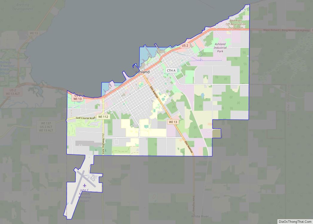
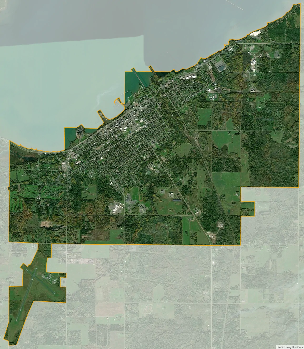
Ashland is a city in Ashland and Bayfield counties in the U.S. state of Wisconsin. It is the county seat of Ashland County. The city is a port on Lake Superior, near the head of Chequamegon Bay. The population was 7,908 at the 2020 census, all of whom resided in the Ashland County portion of the city. The unpopulated Bayfield County portion is in the city’s southwest, bordered by the easternmost part of the Town of Eileen.
The junction of US Highway 2 (US 2) and Wisconsin Highway 13 (WIS 13) is located at this city. It is the home of Northland College, Northwood Technical College, and the Sigurd Olson Environmental Institute.
| Name: | Ashland city |
|---|---|
| LSAD Code: | 25 |
| LSAD Description: | city (suffix) |
| State: | Wisconsin |
| County: | Ashland County, Bayfield County |
| Elevation: | 671 ft (205 m) |
| Total Area: | 13.60 sq mi (35.22 km²) |
| Land Area: | 13.35 sq mi (34.56 km²) |
| Water Area: | 0.26 sq mi (0.66 km²) |
| Total Population: | 7,908 |
| Population Density: | 580/sq mi (220/km²) |
| ZIP code: | 54806 |
| FIPS code: | 5503225 |
| GNISfeature ID: | 1560982 |
| Website: | www.coawi.org |
Online Interactive Map
Click on ![]() to view map in "full screen" mode.
to view map in "full screen" mode.
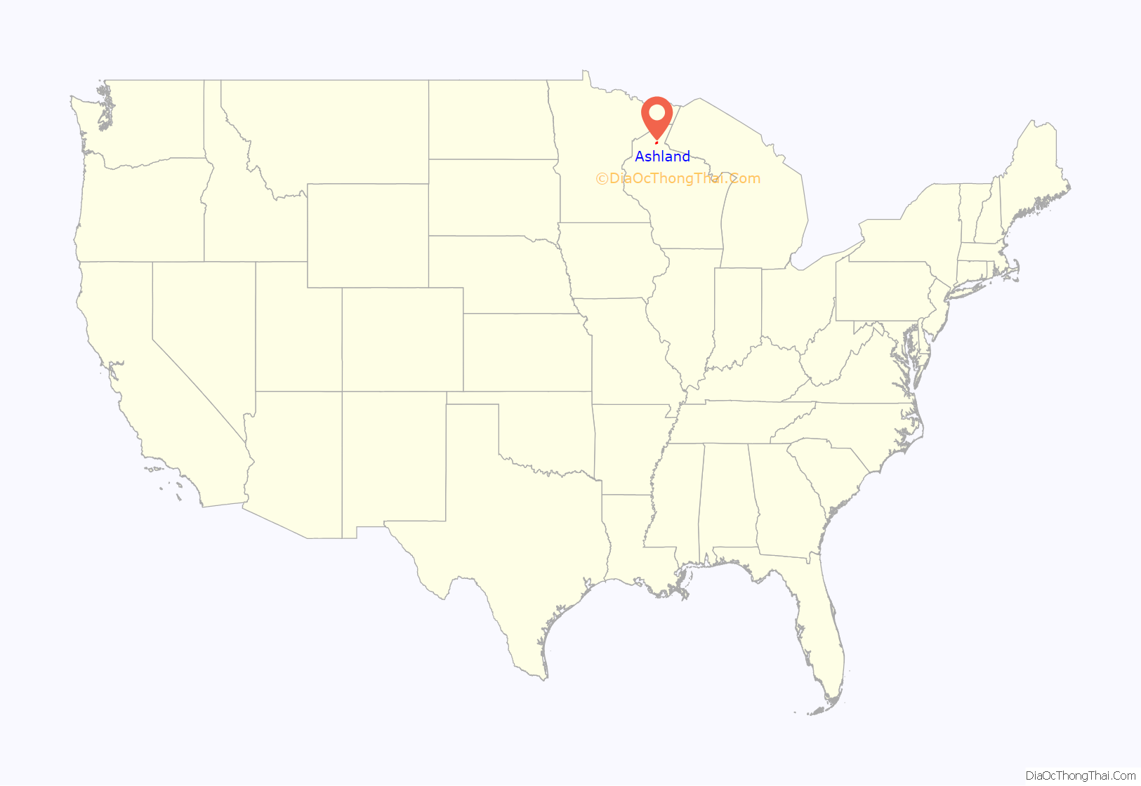
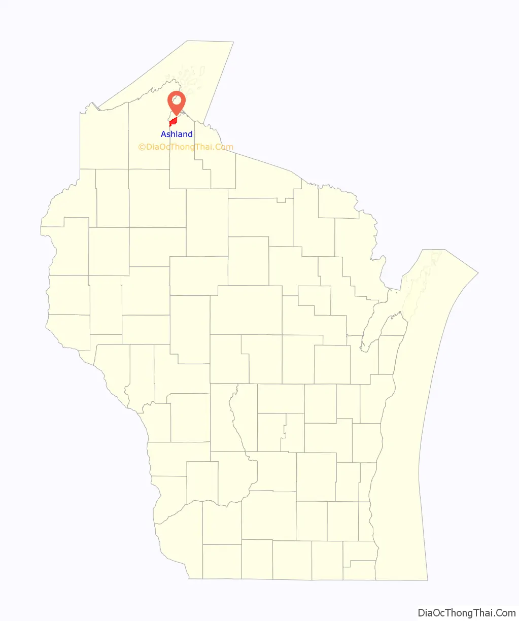
Ashland location map. Where is Ashland city?
History
Pre-settlement
Eight Native American nations have lived on Chequamegon Bay. Later settlers included European explorers, missionaries and fur traders, and more recently, Yankees from the eastern United States who platted and developed the lands, railroaders, shippers, loggers, entrepreneurs, and other settlers. Four flags have flown over the area around Ashland from colonial to contemporary times: Spanish, French, English and American.
The area was part of the United States’ Northwest Territory. This region was divided into four successive territories for administration before becoming part of the state of Wisconsin: Indiana Territory, Michigan Territory, Illinois Territory, and Wisconsin Territory.
About the time Christopher Columbus arrived in the New World in the late 15th century, the Ojibwe people came to the land they called Sha-ga-waun-il-ong. This term has been translated numerous ways: “lowlands”, the “needle”, “the region of shallow water”, and where “there are large extended breakers”. Each is descriptive and suitably accurate. The Ojibwe stayed on Chequamegon Point for nearly a century before leaving. They settled first on Madeline Island and then moved to the Sault Ste. Marie region.
French fur traders Pierre d’Esprit, le Sieur Radisson and Medard Chouart, le Sieur des Groseillers were the first Europeans of record to visit Chequamegon Bay. They arrived in 1659 and built what has been called the first European dwelling place in what is now Wisconsin. A historical marker noting this is located at Maslowski Beach on US 2 on the west end of Ashland. The monument was erected in 1929 by the Old Settlers Club.
The Ojibwe heartily welcomed the Frenchmen. Five years later, Father Claude-Jean Allouez arrived. A Jesuit missionary, he brought the first word of Christianity to Wisconsin’s shores. Allouez built a chapel not far from the stockade erected by Radisson and Groseillier; he worked and lived at the Bay until 1669.
Settlement
In 1854, Ohioans Asaph Whittlesey and George Kilborn set out from La Pointe to explore the head of Chequamegon Bay. Whittlesey built a 10 ft (3.0 m) × 14 ft (4.3 m) cabin in Ashland. His wife, Lucy, and daughter, Eugenia, joined him in August and prepared to winter in their new home. Signs of settlement soon began to take place. The first community dance was held at their house. The Reverend L.H. Wheeler preached the first sermon on the first Independence Day that was observed there. This village was the location of the first post office and polling place for county offices. Sunday school was also conducted on the premises.
The Milwaukee, Lakeshore and Western Railroad platted the city in 1885, as railroad construction moved westward. Local landowner Martin Beaser named the settlement Ashland after Kentucky statesman Henry Clay’s residence. Previous names for the area included Bay City, Saint Mark (for Saint Mark’s Basilica), and Whittlesey, the latter in honor of initial postmaster Adolph Whittlesey.
In the nineteenth century, immigrants to the area included many individuals and families from Germany and northern Europe, as shown by the numerous Lutheran churches in town. Some were initially attracted to agriculture or jobs in the mining industry.
Tar and feather attacks during World War I
During the last year of World War I, from March–October 1918, six recorded incidents of vigilantism took place in the Ashland area, committed against men of German descent, who were suspected of pro-German sympathies.
In Ashland mobs of masked men abducted individuals at night from their homes, driving each to secluded areas where the men were tarred and feathered. A group identifying as the Knights of Liberty claimed responsibility for the attacks, saying in a letter to a local paper, “We have no purpose to do injustice to any man, but we do feel that any treasonable and seditious acts, or utterances, demand prompt punishment. These cases must not be allowed to run indefinitely, without anything being done. We want action and we want it now.”
Victims included:
- Professor E. A. Schimler, abducted, tarred and feathered on March 31, 1918. Born in Germany, Schimler taught French at local Northland College. He was unable to identify any of his assailants.
- Bartender Adolph Anton, taken from his home on April 9, and stripped, tarred and feathered for his suspected “pro-Germanism”. Anton claimed to recognize two of the men, Ephraim Gay and George Buchanan, who were arrested, pleaded not guilty, and released on their own recognizance. A municipal judge dismissed the cases at the preliminary hearing in July. Anton left Ashland, moving to Gary, Indiana.
- William Landraint, 62, was seized in front of a downtown hotel by a mob of fifty men who put a bag over his head, handcuffed him, and drove him to the country, where he was tarred and feathered. Of German birth, Landraint was a deputy tax assessor who had been forced out of his job because of prejudice and suspected disloyalty. Despite dozens of witnesses to the kidnapping by unmasked men, none claimed to know any of the participants. Landraint later asked for police protection after receiving a threatening letter. He soon left town for St. Paul, Minnesota.
- In early June 1918 Emil Kunze went to Ashland police headquarters to report hearing men outside his home conspiring to tar and feather him for his alleged pro-Germanism. He asked for permission to sleep in the jail. He later quit his truck driving job and left town.
- In early July 1918 farmer Martin Johnson of nearby Sweden, Wisconsin was visited at his home by men asking assistance in locating a nearby fishing stream. Once away from the house, they drove Johnson to a secluded area, and stripped, tarred and feathered him.
- On October 25, 1918, John Oestrycher, a farmer living eight miles outside Ashland, was tarred and feathered for not buying Liberty Bonds and for being “pro-German”.
Governor Emanuel Philipp expressed his indignation over these incidents, as well as reports of local ethnic Germans receiving threatening letters. He directed state Attorney General Spencer Haven to launch an inquiry. His investigator found the local citizenry uncooperative, including John C. Chapple, editor of the Ashland Daily Press and campaign manager for Roy P. Wilcox, a Republican candidate for governor proclaiming his own patriotism. The inquiry found the community generally satisfied with the treatment of the first victims. Haven expressed frustration at the local court, which refused to adjourn to allow the securing of evidence, and at the district attorney, who dismissed the first two cases for lack of said evidence. Haven threatened to send a company of the state guard to maintain law and order in the area. Ultimately no one was convicted for any of the attacks. Two months after the world war ended, newspapers reported that the local Knights of Liberty had disbanded. The Milwaukee Journal reported that more than 800 men in Ashland County belonged to the order.
Dates of note
- 1856 — First plat of Ashland registered
- 1870 — First Ashland brownstone quarried and shipped
- 1872 — First sawmill built by W.R. Sutherland
- 1872 — The Ashland Weekly Press is founded by Sam Fifield. It became a daily paper more than a decade later. The first issue of the Ashland Daily Press was March 5, 1888.
- 1874 — First brewery built, Ashland Brewing Company
- 1877 — Wisconsin Central Railroad connected Ashland to Chicago
- 1877 — Chequamegon Hotel opened, one block from current hotel
- 1887 — State legislature incorporated the City of Ashland
- 1889 — Wisconsin Central Depot constructed
- 1892 — Northern Wisconsin Academy opened (now Northland College)
- 1892 — Ashland Post Office built
- 1904 — Ashland High School opened
- 1918 – During the last year of the war, at least six men were individually attacked by vigilante groups acting against ethnic Germans
- 1929 — First airport opened
- 1940 — WATW radio went on the air
- 1970 — Establishment of the Apostle Islands National Lakeshore
- 1972 — Memorial Medical Center opened
- 1979 — The Union Depot is listed on the National Register of Historic Places.
- 1984 — The West Second Street Historic District is listed on the National Register of Historic Places. Second Street was later renamed Main Street.
- 1998 — Northern Great Lakes Visitor Center is built
- 2009 — Ore dock slated for demolition. Attempts by community members to preserve the historic structure were not successful.
- 2014 — The Chapple and MacArthur Avenues Residential Historic District is listed on the National Register of Historic Places.
- 2016 — New fire hall dedicated, replacing the historic, century-old Ellis Fire Station.
- 2016 — From July 11 until August, Ashland suffered one of the worst storm seasons in its history. Highways going to Ironwood and Marengo were severely damaged, as were portions of infrastructure at Saxon Harbor. Residents reported flooding of many basements by lake and rain waters. Three deaths were reported.
Ore dock
The harbor of Ashland was dominated by the massive Wisconsin Central Railway (later Soo Line) ore dock, built in 1916 to load iron ore mined in the area into freighters bound for industrial ports in the Midwest, such as Ashtabula, Ohio, where steel was produced. The last of what had once been many such docks, the concrete structure is 80 feet (24 m) high and 75 feet (23 m) wide. In 1925 the dock was extended to 1,800 feet (550 m); it was last used to ship ore in 1965.
In 2007 the Wisconsin Trust for Historic Preservation named it one of the “10 most endangered historic buildings in Wisconsin”, a list intended to stir preservation efforts. The main concrete structure and trestle had slowly deteriorated since the early 1970s because of lack of maintenance and the effects of the environment. A structural inspection completed in 2006 and 2007 concluded that the ore dock had become structurally unsafe and was an imminent safety hazard. On May 14, 2009, the Ashland Planning Commission granted Canadian National Railway approval for demolition of the dock. All material on the ore dock was removed, down to the concrete base. This was completed in 2013.
The base of the ore dock remains. The city took ownership of it from Canadian National Railway in May 2014. It is working with a consultant group to design a redevelopment plan for the base of the dock.
Ashland Road Map
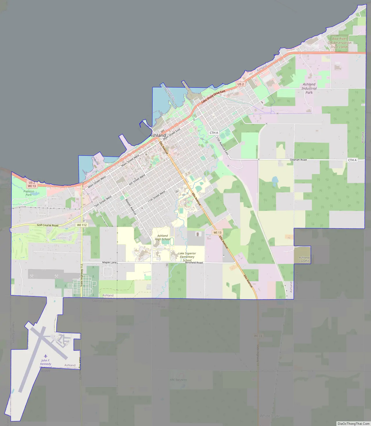
Ashland city Satellite Map
Geography
Ashland is located along the south shore of Chequamegon Bay. According to the United States Census Bureau, the city has a total area of 13.70 square miles (35.48 km), of which 13.42 square miles (34.76 km) is land and 0.28 square miles (0.73 km) is water.
Climate
Ashland has a humid continental climate (Koppen: Dfb) with four distinct seasons and notably cold winters. Due to the city’s proximity to Lake Superior, it sometimes has lake effect snow storms, with high amounts of snow recorded.
See also
Map of Wisconsin State and its subdivision:- Adams
- Ashland
- Barron
- Bayfield
- Brown
- Buffalo
- Burnett
- Calumet
- Chippewa
- Clark
- Columbia
- Crawford
- Dane
- Dodge
- Door
- Douglas
- Dunn
- Eau Claire
- Florence
- Fond du Lac
- Forest
- Grant
- Green
- Green Lake
- Iowa
- Iron
- Jackson
- Jefferson
- Juneau
- Kenosha
- Kewaunee
- La Crosse
- Lafayette
- Lake Michigan
- Lake Superior
- Langlade
- Lincoln
- Manitowoc
- Marathon
- Marinette
- Marquette
- Menominee
- Milwaukee
- Monroe
- Oconto
- Oneida
- Outagamie
- Ozaukee
- Pepin
- Pierce
- Polk
- Portage
- Price
- Racine
- Richland
- Rock
- Rusk
- Saint Croix
- Sauk
- Sawyer
- Shawano
- Sheboygan
- Taylor
- Trempealeau
- Vernon
- Vilas
- Walworth
- Washburn
- Washington
- Waukesha
- Waupaca
- Waushara
- Winnebago
- Wood
- Alabama
- Alaska
- Arizona
- Arkansas
- California
- Colorado
- Connecticut
- Delaware
- District of Columbia
- Florida
- Georgia
- Hawaii
- Idaho
- Illinois
- Indiana
- Iowa
- Kansas
- Kentucky
- Louisiana
- Maine
- Maryland
- Massachusetts
- Michigan
- Minnesota
- Mississippi
- Missouri
- Montana
- Nebraska
- Nevada
- New Hampshire
- New Jersey
- New Mexico
- New York
- North Carolina
- North Dakota
- Ohio
- Oklahoma
- Oregon
- Pennsylvania
- Rhode Island
- South Carolina
- South Dakota
- Tennessee
- Texas
- Utah
- Vermont
- Virginia
- Washington
- West Virginia
- Wisconsin
- Wyoming