Kensington is an unincorporated community and census designated place located in the Berkeley Hills, in the East Bay, part of the San Francisco Bay Area, in Contra Costa County, California. In the 20th century it was considered part of Berkeley, although it is across the county line. House numbers follow the pattern used in Berkeley, and Kensington shares two zip codes with the Berkeley Hills area.
The population was 5,077 at the 2010 census.
| Name: | Kensington CDP |
|---|---|
| LSAD Code: | 57 |
| LSAD Description: | CDP (suffix) |
| State: | California |
| County: | Contra Costa County |
| Elevation: | 587 ft (179 m) |
| Total Area: | 0.956 sq mi (2.48 km²) |
| Land Area: | 0.947 sq mi (2.45 km²) |
| Water Area: | 0.009 sq mi (0.02 km²) 0.97% |
| Total Population: | 5,077 |
| Population Density: | 5,300/sq mi (2,100/km²) |
| ZIP code: | 94707, 94708 |
| Area code: | 510, 341 |
| FIPS code: | 0638086 |
Online Interactive Map
Click on ![]() to view map in "full screen" mode.
to view map in "full screen" mode.
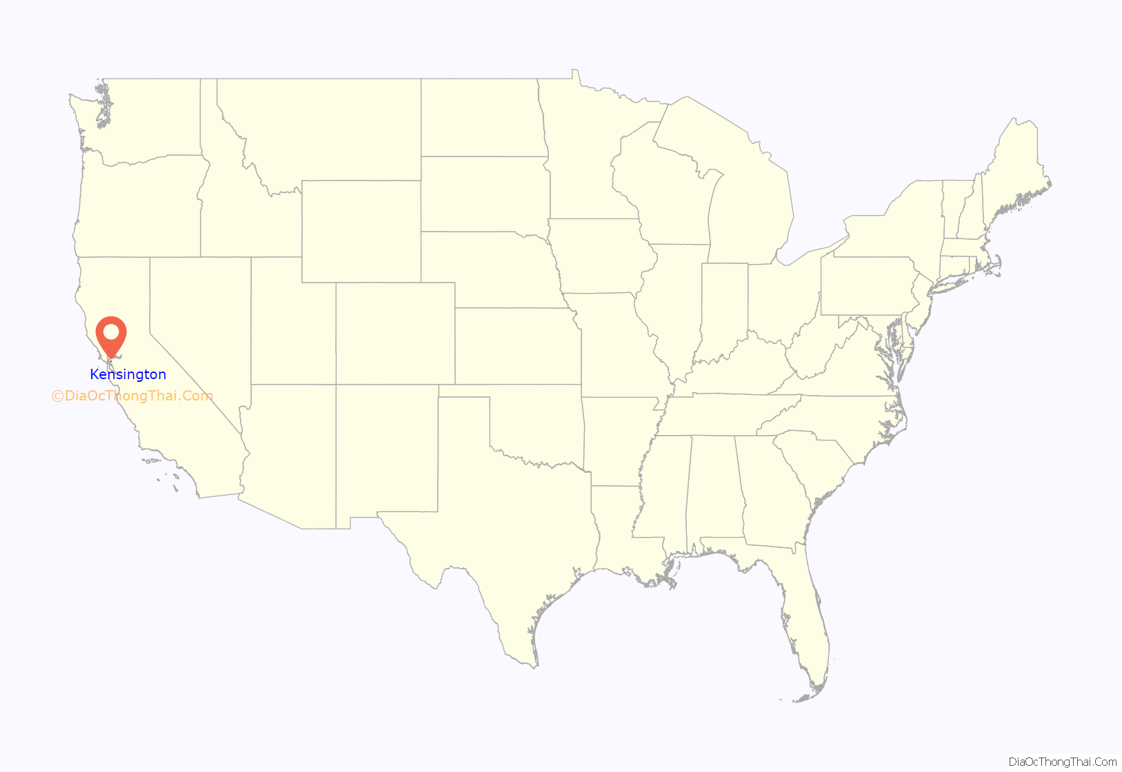
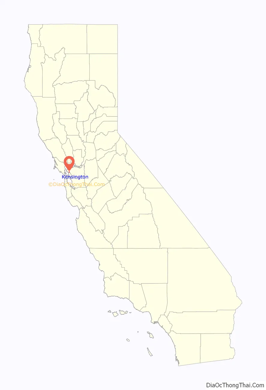
Kensington location map. Where is Kensington CDP?
History
The area that is now Kensington was originally the territory of the Huchiun band of the Ohlone Indigenous people who occupied much of the East Bay of the San Francisco Bay Area. The Pedro Fages mapping expedition passed through the area in 1772.
In 1823, the Republic of Mexico granted Rancho San Pablo, an extent of land lying north of Cerrito Creek and the Rancho San Antonio, including that portion of land that is now Kensington, to Francisco María Castro, a veteran of the Mexican Army and former alcalde of San José. In 1831 his youngest son, Victor Castro, inherited the southern portion of the rancho, including what is now Kensington.
In 1892, Anson Blake purchased a portion of Castro’s land, most of which is now Kensington.
George Shima bought ten acres north of Cerrito Creek and east of the present day Arlington Avenue in about 1911, intending to build a home there. He hosted an annual community picnic on the property for some time.
Land development companies had bought most of the Kensington area by 1911, when it was first surveyed. The area was named “Kensington” that year by Robert Brousefield, a surveyor who had lived in the London district of South Kensington in the Royal Borough of Kensington and Chelsea at one time. The first subdivisions were Kensington Park and Berkeley Park west of Arlington Avenue, with most streets named for locations in England, and Berkeley Highlands, with most streets named for colleges and universities.
Farmers in Kensington resisted inclusion in the city of El Cerrito when it was incorporated in 1917, and local voters have rejected incorporation various times since then.
In the 1920s, the East Bay Municipal Utility District (EBMUD) constructed an aqueduct through the Berkeley Hills to transport water from the San Pablo Reservoir to a still-active pumping facility in Kensington, located just above the Colusa Circle. Some of the water received by this facility is pumped up the hill to the Summit Reservoir located at the top of Spruce Street. The rest is pumped to other reservoirs serving the East Bay.
The population of Kensington was 226 in 1920, 1,423 in 1930, 3,355 in 1940, and reached a peak of 6,601 in 1950.
During World War II, J. Robert Oppenheimer lived at 10 Kenilworth Court where he held meetings of the American Communist Party, while simultaneously working on top secret atomic bomb work, and denying any involvement with such political groups. The house is often mistakenly described as being in Berkeley. Later in his life, Oppenheimer lived at 1 Eagle Hill, also in Kensington.
Until 1948, streetcar line #7 of the Key System ran to Kensington from Berkeley along Arlington Avenue, terminating in the small commercial area at Amherst Avenue. The streetcar was then replaced by an AC Transit bus route of the same number, which continues to run along Arlington Avenue. The streetcar service played an important role in the development of Kensington, and was fed by a network of mid-block pedestrian paths, most of which persist to this day. The pathways, which traverse Kensington, were offered for dedication for public use to the County of Contra Costa at the time the various subdivision maps were recorded. The County never accepted the offer of dedication, and accordingly, the ownership of the pathways has been in a state of uncertainty. Some of the pathways are used by the public regularly, and some have fallen into disuse, are overgrown with foliage, or have been absorbed into neighboring properties.
The late local historian Louis Stein Jr. lived and worked in Kensington, maintaining a pharmacy on the corner of Amherst and Arlington Avenue. For many years, he kept one of the East Bay’s oldest horsecars in his yard—one that had probably seen service between Temescal, Oakland and the University of California in Berkeley. The horsecar is now at the Western Railway Museum.
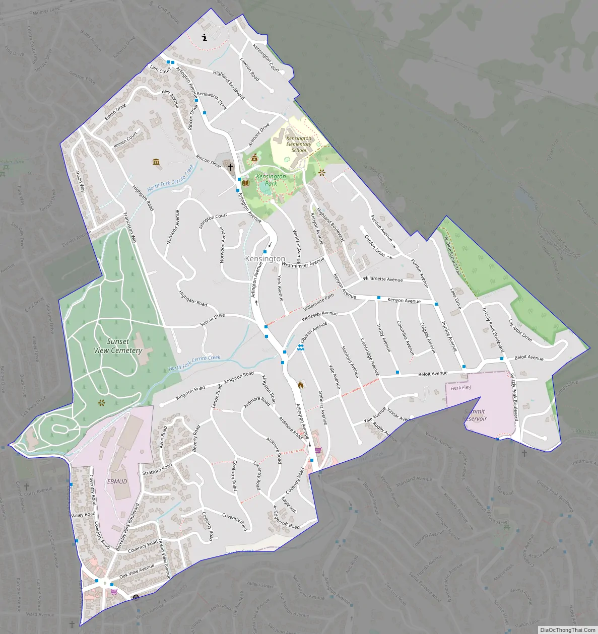
Kensington Road Map
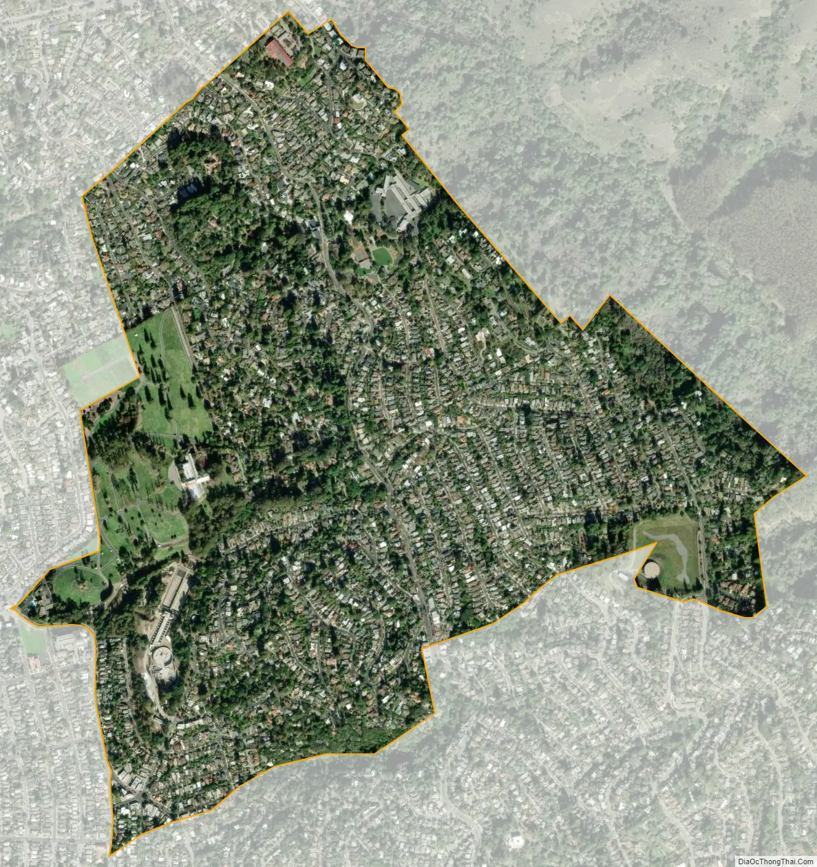
Kensington city Satellite Map
Geography
According to the United States Census Bureau, the CDP has a total area of 1.0 square mile (2.6 km).
Kensington borders Berkeley and Albany to the south, El Cerrito to its west and north, and Wildcat Canyon Regional Park and Tilden Regional Park to the east.
Kensington is mostly single-family residential, with two small shopping districts. One of these is located on Arlington Avenue (at Amherst), the other centered on the Colusa Circle.
See also
Map of California State and its subdivision:- Alameda
- Alpine
- Amador
- Butte
- Calaveras
- Colusa
- Contra Costa
- Del Norte
- El Dorado
- Fresno
- Glenn
- Humboldt
- Imperial
- Inyo
- Kern
- Kings
- Lake
- Lassen
- Los Angeles
- Madera
- Marin
- Mariposa
- Mendocino
- Merced
- Modoc
- Mono
- Monterey
- Napa
- Nevada
- Orange
- Placer
- Plumas
- Riverside
- Sacramento
- San Benito
- San Bernardino
- San Diego
- San Francisco
- San Joaquin
- San Luis Obispo
- San Mateo
- Santa Barbara
- Santa Clara
- Santa Cruz
- Shasta
- Sierra
- Siskiyou
- Solano
- Sonoma
- Stanislaus
- Sutter
- Tehama
- Trinity
- Tulare
- Tuolumne
- Ventura
- Yolo
- Yuba
- Alabama
- Alaska
- Arizona
- Arkansas
- California
- Colorado
- Connecticut
- Delaware
- District of Columbia
- Florida
- Georgia
- Hawaii
- Idaho
- Illinois
- Indiana
- Iowa
- Kansas
- Kentucky
- Louisiana
- Maine
- Maryland
- Massachusetts
- Michigan
- Minnesota
- Mississippi
- Missouri
- Montana
- Nebraska
- Nevada
- New Hampshire
- New Jersey
- New Mexico
- New York
- North Carolina
- North Dakota
- Ohio
- Oklahoma
- Oregon
- Pennsylvania
- Rhode Island
- South Carolina
- South Dakota
- Tennessee
- Texas
- Utah
- Vermont
- Virginia
- Washington
- West Virginia
- Wisconsin
- Wyoming


