Fresno (/ˈfrɛznoʊ/ (listen)) is a major city in the San Joaquin Valley of California, United States. It is the county seat of Fresno County and the largest city in the greater Central Valley region. It covers about 115 square miles (300 km) and had a population of 542,107 as of the 2020 Census, making it the fifth-most populous city in California, the most populous inland city in California, and the 33rd-most populous city in the nation.
Named for the abundant ash trees lining the San Joaquin River, Fresno was founded in 1872 as a railway station of the Central Pacific Railroad before it was incorporated in 1885. It has since become an economic hub of Fresno County and the San Joaquin Valley, with much of the surrounding areas in the Metropolitan Fresno region predominantly tied to large-scale agricultural production. Fresno is near the geographic center of California, approximately 220 miles (350 km) north of Los Angeles, 170 miles (270 km) south of the state capital, Sacramento, and 185 miles (300 km) southeast of San Francisco. Yosemite National Park is about 60 miles (100 km) to the north, Kings Canyon National Park 60 miles (100 km) to the east, and Sequoia National Park 75 miles (120 km) to the southeast.
Fresno is also the third-largest majority-Hispanic city in the United States, 50.5% of its population being Hispanic in 2020.
| Name: | Fresno city |
|---|---|
| LSAD Code: | 25 |
| LSAD Description: | city (suffix) |
| State: | California |
| County: | Fresno County |
| Incorporated: | October 21, 1885 |
| Elevation: | 308 ft (94 m) |
| Land Area: | 114.79 sq mi (297.30 km²) |
| Water Area: | 1.21 sq mi (3.13 km²) 1.04% |
| Population Density: | 4,722.60/sq mi (1,823.43/km²) |
| Area code: | 559 |
| FIPS code: | 0627000 |
| Website: | www.fresno.gov |
Discover the city of Fresno with this interactive map.
Explore the city of Fresno, California with this interactive Fresno map. The map features highways/roads, points of interest, and things to do. Orient yourself and explore the city of Fresno, California to gain a wider perspective of this beautiful city. Fresno is located in central California in the San Joaquin Valley of California and has a population of around 525,000, making it the most populous city that’s completely part of inland California. Print these Fresno maps to understand why Fresno is home to many of California’s important parks, museums, galleries, and landmarks.
Online Interactive Map
Click on ![]() to view map in "full screen" mode.
to view map in "full screen" mode.
With this interactive map, you’ll be able to discover the best places to eat and drink, shop, and stay. Get a comprehensive map of Fresno, California with detailed information on the top attractions, businesses, tourist attractions, and even local restaurants in the area.
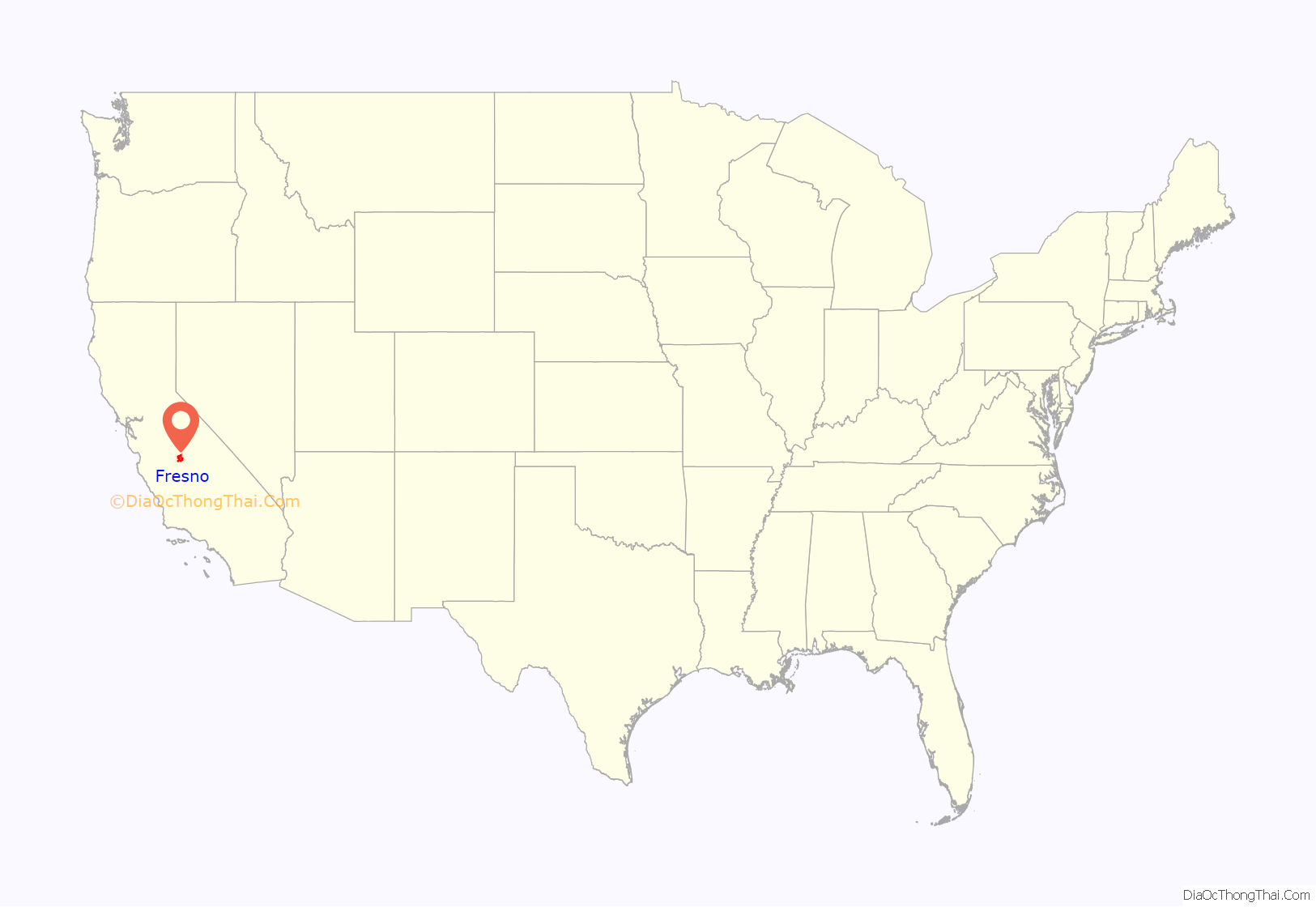
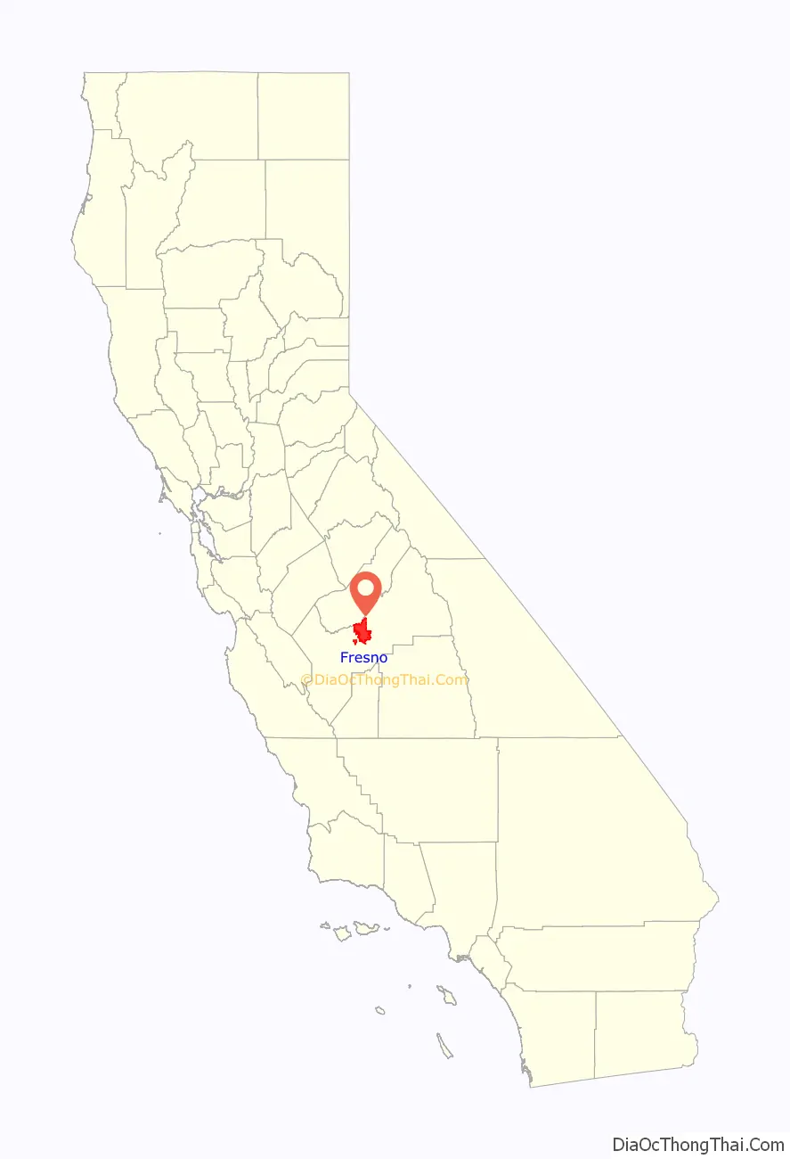
Fresno location map. Where is Fresno city?
History
The original inhabitants of the San Joaquin Valley region were the Yokuts people and Miwok people, who engaged in trading with other Californian tribes of Native Americans including coastal peoples such as the Chumash of the Central California coast, with whom they are thought to have traded plant and animal products.
The first European to enter the San Joaquin Valley was Pedro Fages in 1772. The county of Fresno was formed in 1856 after the California Gold Rush. It was named for the abundant ash trees (Spanish: fresno) lining the San Joaquin River.
The San Joaquin River flooded on December 24, 1867, inundating Millerton. Some residents rebuilt, others moved. Flooding also destroyed the town of Scottsburg on the nearby Kings River that winter. Rebuilt on higher ground, Scottsburg was renamed Centerville.
In 1867, Anthony Easterby purchased land bounded by the present Chestnut, Belmont, Clovis and California avenues, that today is called the Sunnyside district. Unable to grow wheat for lack of water, he hired sheep man Moses Church in 1870 to create an irrigation system. Building new canals and purchasing existing ditches, Church then formed the Fresno Canal and Irrigation Company, a predecessor of the Fresno Irrigation District.
In 1872, the Central Pacific Railroad established a station near Easterby’s—by now a hugely productive wheat farm—for its new Southern Pacific line. Soon there was a store near the station and the store grew into the town of Fresno Station, later called Fresno. At that time, Mariposa street was the main artery, a rough dusty or muddy depression. Many Millerton residents, drawn by the convenience of the railroad and worried about flooding, moved to the new community. Fresno became an incorporated city in 1885. In 1903, the faltering San Joaquin Power Company was renamed the San Joaquin Light and Power Corporation and included the Fresno City Water Company and the Fresno City Railway. By 1931 the railway, now known as the Fresno Traction Company, operated 47 streetcars over 49 miles (79 km) of track.
In 1865, William Helm brought his sheep to Fresno county, which was then a vast space of open land. By 1877, Helm made Fresno his home with a five-acre tract of land at the corner of Fresno and R streets. Helm was the largest individual sheep grower in Fresno County.
Two years after the station was established, county residents voted to move the county seat from Millerton to Fresno. When the Friant Dam was completed in 1944, the site of Millerton became inundated by the waters of Millerton Lake. In extreme droughts, when the reservoir shrinks, ruins of the original county seat can still be observed.
In the nineteenth century, with so much wooden construction and in the absence of sophisticated firefighting resources, fires often ravaged American frontier towns. The greatest of Fresno’s early-day fires, in 1882, destroyed an entire block of the city. Another devastating blaze struck in 1883.
In 1909, Fresno’s first and oldest synagogue, Temple Beth Israel, was founded.
Fresno entered the ranks of the 100 most populous cities in the United States in 1960 with a population of 134,000. Thirty years later, in the 1990 census, it moved up to 47th place with 354,000, and in the census of 2000, it achieved 37th place with 428,000.
The Fresno Municipal Sanitary Landfill was the first modern landfill in the United States, and incorporated several important innovations to waste disposal, including trenching, compacting, and the daily covering of trash with dirt. It was opened in 1937 and closed in 1987. It is a National Historic Landmark as well as a Superfund site.
Before World War II, Fresno had many ethnic neighborhoods, including Little Armenia, German Town, Little Italy, and Chinatown. In 1940, the Census Bureau reported Fresno’s population as 94.0% white, 3.3% black and 2.7% Asian. Chinatown was primarily a Japanese neighborhood and today few Japanese-American businesses remain. During 1942, Pinedale, in what is now North Fresno, was the site of the Pinedale Assembly Center, an interim facility for the relocation of Fresno area Japanese Americans to internment camps. The Fresno Fairgrounds were also utilized as an assembly center.
Row crops and orchards gave way to urban development particularly in the period after World War II; this transition was particularly vividly demonstrated in locations such as the Blackstone Avenue corridor.
In September 1958, Bank of America launched a new product called BankAmericard in Fresno. After a troubled gestation during which its creator resigned, BankAmericard went on to become the world’s first successful credit card. This financial instrument was usable across a large number of merchants and also allowed cardholders to revolve a balance (earlier financial products could do one or the other but not both). In 1976, BankAmericard was renamed and spun off into a separate company known today as Visa Inc.
The dance style commonly known as popping evolved in Fresno in the 1970s.
In 1995, the Federal Bureau of Investigation’s Operation Rezone sting resulted in several prominent Fresno and Clovis politicians being charged in connection with taking bribes in return for rezoning farmland for housing developments. Before the sting brought a halt to it, housing developers could buy farmland cheaply, pay off council members to have it rezoned, and make a large profit building and selling inexpensive housing. Sixteen people were eventually convicted as a result of the sting.
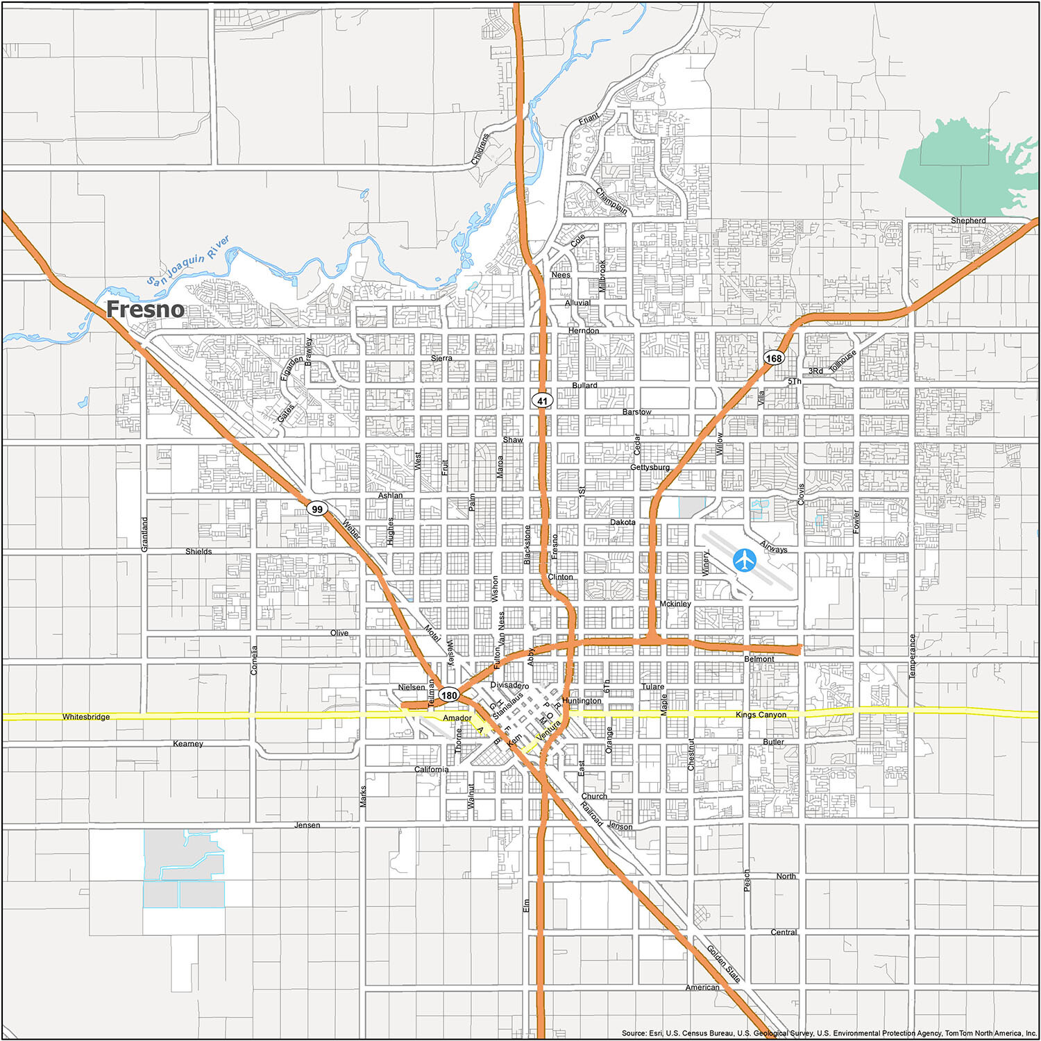
Fresno Road Map
This map is a great way to get around and see the beautiful city that is Fresno. Plan your trip with ease. With this map, you can find the quickest way to get to your destination. You can also learn about the road network and its major highways and roads, such as US Highways 2, 41, 99, 168, 180, and Major Roads 1st St, 6th St, 7th St, Abby St, Airport Rd, Alluvial Ave, Andersen Ave, Audubon Dr, Barstow Ave, Beechwood Ave, Belmont Ave, Brawley Ave, Broadway St, Butler Ave, California Ave, Cedar Ave, Champlain Dr, Chandler Ave, Chestnut Ave, Chestnut Diagonal, Church Ave, Clinton Ave, Copper Ave, Cornelia Ave, Dakota Ave, Figarden Dr, Fowler Ave, Franklin Ave, Fresno St, Friant Rd, Fulton St, Gates Ave, Gettysburg Ave, Golden State Blvd, Grantland Ave, Hughes Ave, Hughes West Diagonal Ave, Huntington Blvd, International Ave, Jenson Byp, Kearney Blvd, Kings Canyon Rd, Los Angeles St, Maple Ave, Mariposa St, Martin Ave, Martin Luther King Jr Blvd, McKinley Ave, Nees Ave, Northridge Ave, Olive Ave, Orange Ave, Pacific Ave, Palm Ave, Parkway Dr, Peach Ave, Shaw Ave, Sierra Ave, Sommerville Dr, Stanislaus St, Thorne Ave, Trinity St, Tulare St, Ventura St, Walnut Ave, Weber Ave, Wesley Ave, Willow Ave, Winery Ave, Wishon Ave. If you want to travel outside the city, make sure to take a look at our California road map that provides an overview for statewide travel.
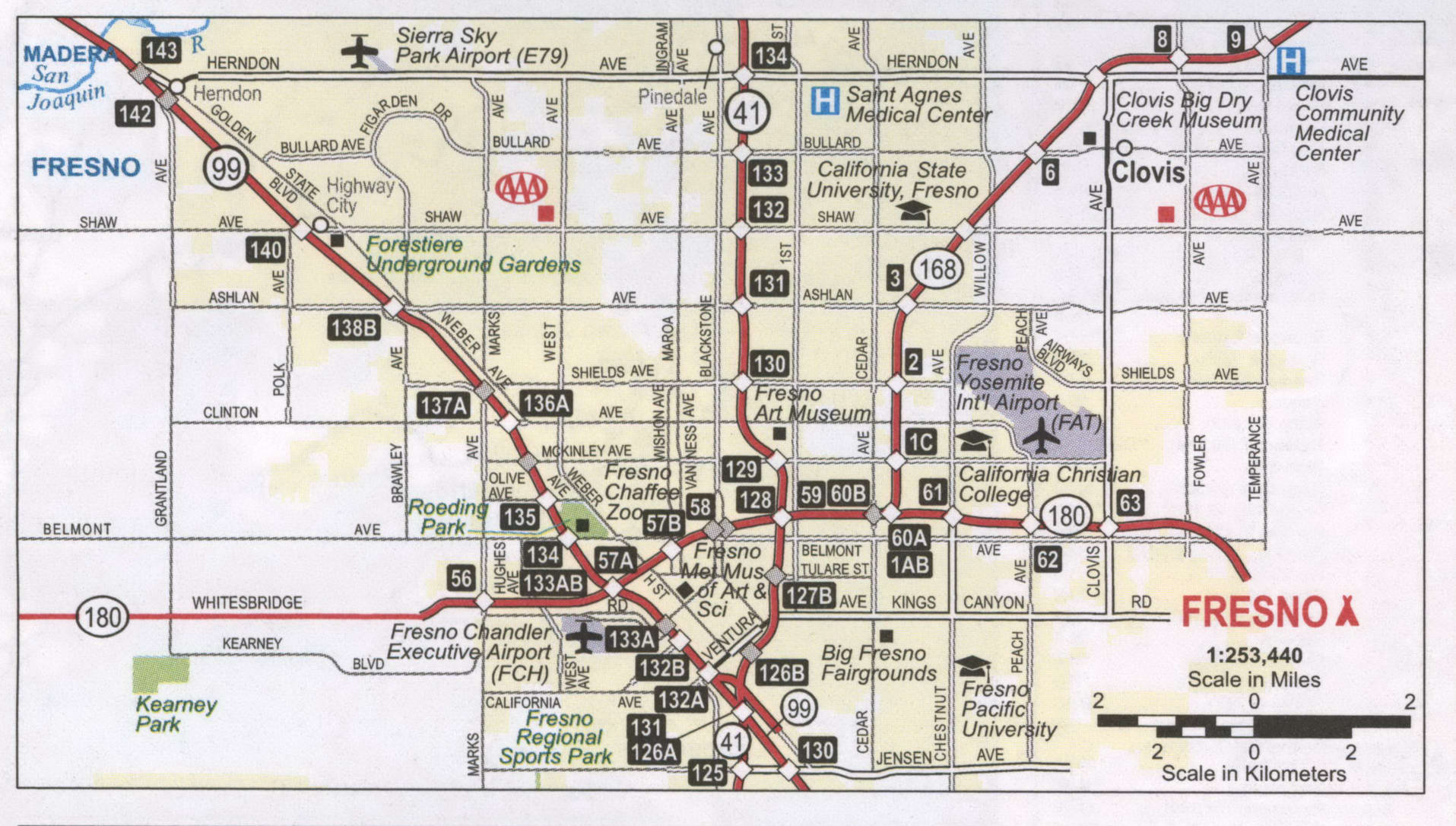
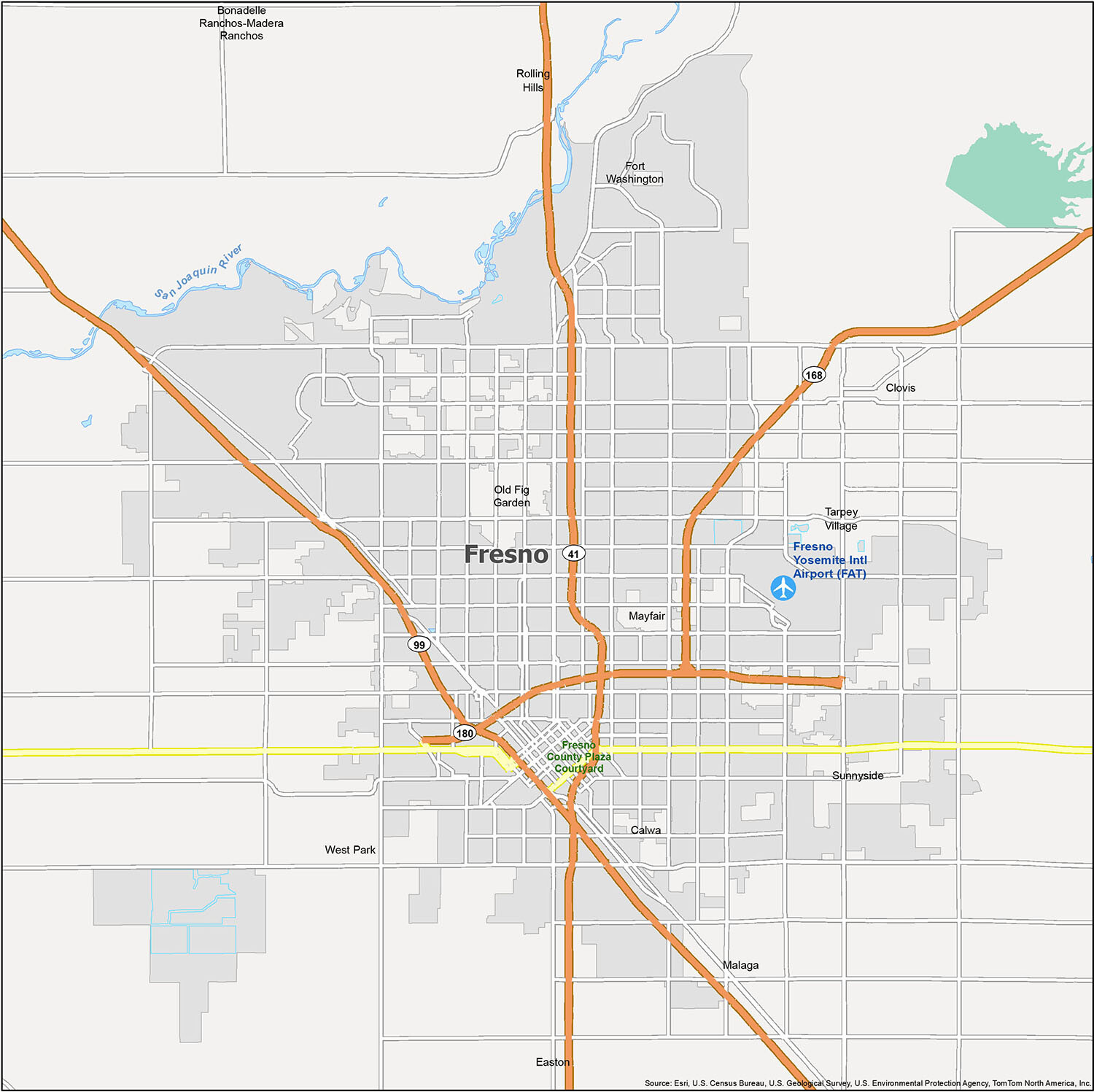
Explore the city with this must-have map! Discover rivers and populated areas outside the city limits, including Fresno Yosemite International Airport (FAT), Clovis, Fresno, Bonadelle Ranchos-Madera Ranchos, Calwa, Easton, Fort Washington, Malaga, Mayfair, Old Fig Garden, Rolling Hills, Sunnyside, Tarpey Village, West Park and the San Joaquin River.
10 things to do in Fresno city
Fresno, California is a great place to visit for a weekend getaway or for a longer stay. With its rich culture and history, there is something for everyone. From exploring the city center to visiting the nearby attractions, you’ll be sure to find something to enjoy in Fresno.
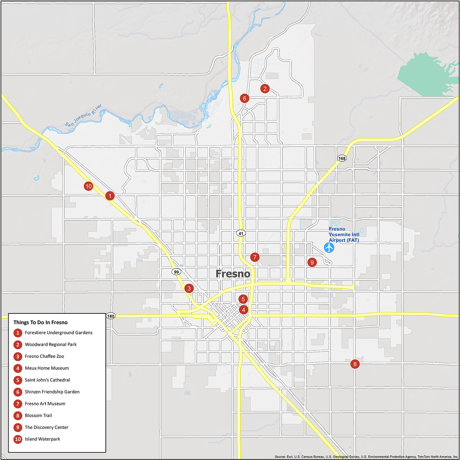
Discover the beauty of Fresno, California and all that it has to offer with this perfect overview of the city. From its city center to historical sites, attractions, and more, you’ll be surprised how easy it is to explore Fresno. Here’s a list of some of its highlights:
- Forestiere Underground Gardens
- Woodward Regional Park
- Fresno Chaffee Zoo
- Meux Home Museum
- Saint John’s Cathedral
- Shinzen Friendship Garden
- Fresno Art Museum
- Blossom Trail
- The Discovery Center
- Island Waterpark
Fresno, California is the ideal destination for a weekend getaway or for a longer stay. With its rich culture and history, there is something for everyone. So why not explore the city center and the nearby attractions and discover the beauty of Fresno for yourself?
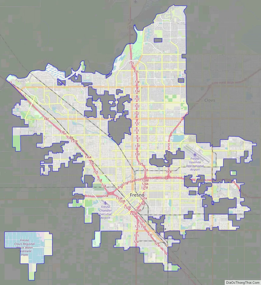
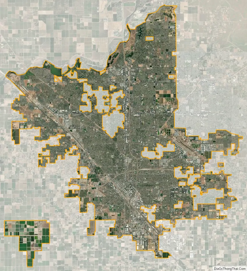
Fresno city Satellite Map
Geography
Fresno has a total area of 116 square miles (300 km) with 98.96% land covering 114.79 square miles (297.3 km), and 1.04% water, 1.21 square miles (3.1 km).
Fresno’s location, very near the geographical center of California, places the city a comfortable distance from many of the major recreation areas and urban centers in the state. Just 60 mi (97 km) south of Yosemite National Park, it is the nearest major city to the park. Likewise, Sierra National Forest is 40 mi (64 km), Kings Canyon National Park is 60 mi (97 km) and Sequoia National Park is 75 mi (121 km). The city is located near several Sierra Nevada lakes including Bass Lake, Shaver Lake, and Huntington Lake. Fresno is also only two and a half hours from Monterey, Carmel, Big Sur and the central coast.
Because Fresno sits at the junction of Highways 41 and 99 (SR 41 is Yosemite National Park’s southern access road, and SR 99 bypasses Interstate 5 to serve the urban centers of the San Joaquin Valley), the city is a major gateway for Yosemite visitors coming from Los Angeles. The city also serves as an entrance into Sierra National Forest via Highway 168, and Sequoia and Kings Canyon National Parks via Highway 180.
Fresno has three large public parks, two in the city limits and one in county land to the southwest. Woodward Park, which features the Shinzen Japanese Gardens, boasts numerous picnic areas and several miles of trails. It is in North Fresno and is adjacent to the San Joaquin River Parkway. Roeding Park, near Downtown Fresno, is home to the Fresno Chaffee Zoo, and Rotary Storyland and Playland. Kearney Park is the largest of the Fresno region’s park system and is home to historic Kearney Mansion and plays host to the annual Civil War Revisited, the largest reenactment of the Civil War in the west coast of the U.S.
In its 2020 ParkScore ranking, The Trust for Public Land, a national land conservation organization, reported that Fresno had one of the worst park systems among the 50 most populous U.S. cities. The survey measures median park size, park acres as percent of city area, residents’ access to parks, spending on parks per resident, and playgrounds per 10,000 residents.
Neighborhoods
Fresno was born with the establishment of the then Central Pacific Railroad Depot in 1872. In 1889, the Southern Pacific Railroad, which had acquired Central Pacific, constructed a new depot on the original depot site. The brick Queen Anne style depot was a jewel for the city and is currently one of Fresno’s oldest standing buildings. In 1971, 99 years after it first opened for business on its current site, the Depot closed its rail operations due to the decline in business.
Between the 1880s and World War II, Downtown Fresno flourished, filled with electric streetcars, and contained a number of “lavish” and “opulent” buildings. Among them, the original Fresno County Courthouse (demolished), the Fresno Carnegie Public Library (demolished), the Old Fresno Water Tower, the Bank of Italy Building, the Pacific Southwest Building, the San Joaquin Light and Power Building (currently known as the Grand 1401), and the Hughes Hotel (burned down), to name a few.
Fulton Street in Downtown Fresno was Fresno’s main financial and commercial district before being converted into one of the nation’s first pedestrian malls in 1964. Renamed the Fulton Mall, the area contains the densest collection of historic buildings in Fresno. While the Fulton Mall corridor has suffered a sharp decline from its heyday, the Mall includes some of the finest public art pieces in the country, including a casting of Pierre-Auguste Renoir’s bronze “The Washer Woman”, reportedly the only one of the six castings that one can walk up to and touch. In October 2017, the City of Fresno finished and opened Fulton Mall to traffic, becoming Fulton Street. This change was celebrated with a large public parade featuring current Mayor Lee Brand and former Mayor Ashley Swearengin. The public art pieces will be restored and placed near their current locations and will feature wide sidewalks (up to 28′ on the east side of the street) to continue with the pedestrian-friendly environment of the district.
The historic Tower Theatre, which is included on the National Register of Historic Places, is the center of the Tower District. The theater was built in 1939 at the corner of Olive and Wishon Avenues. The Tower District neighborhood is just north of downtown Fresno proper, and one-half mile south of Fresno City College. Although the neighborhood was known as a residential area, the early commercial establishments of the Tower District began with small shops and services that flocked to the area shortly after World War II. The character of small local businesses largely remains today. To some extent, the businesses of the Tower District were developed due to the proximity of the original Fresno Normal School (later renamed California State University at Fresno). In 1916, the college moved to what is now the site of Fresno City College one-half mile north of the Tower District.
After decades of neglect and suburban flight, the neighborhood revival followed the re-opening of the Tower Theatre in the late 1970s, which at that time showed second- and third-run movies, along with classic films. Roger Rocka’s Dinner Theater & Good Company Players also opened nearby in 1978, at Olive and Wishon Avenues. Fresno native Audra McDonald performed in the leading roles of Evita and The Wiz at the theater while she was a high school student. McDonald subsequently became a leading performer on Broadway in New York City and a Tony award-winning actress. Also in the Tower District is Good Company Players’ 2nd Space Theatre.
The Tower District is a hub for community events such as Jamaica My Weekend, Mardi Gras in February, Gay Pride Parade, car shows, A Taste of The Tower, Halloween in the Tower, and the Farmers’ market opened on the northwest Corner of Olive and Van Ness.
The neighborhood features restaurants, live theater and nightclubs, as well as several independent shops and bookstores on or near Olive Avenue. Since renewal, the Tower District has become an attractive area for restaurant and other local businesses. The Tower District is known as the center of Fresno’s LGBT and hipster communities.
The area is also known for its early twentieth century homes, many of which have been restored in recent decades. The area includes many California Bungalow and American Craftsman style homes, Spanish Colonial Revival Style architecture, Mediterranean Revival Style architecture, Mission Revival Style architecture, and many Storybook houses designed by Fresno architects, Hilliard, Taylor & Wheeler. The residential architecture of the Tower District contrasts with the newer areas of tract homes urban sprawl in north and east areas of Fresno.
In the northeastern part of Fresno, Woodward Park was founded by the late Ralph Woodward, a long-time Fresno resident. He bequeathed a major portion of his estate in 1968 to provide a regional park and bird sanctuary in Northeast Fresno. The park lies on the southern bank of the San Joaquin River between Highway 41 and Friant Road. The initial 235 acres (0.95 km), combined with additional acres acquired later by the city, brings the park to a sizable 300 acres (1.2 km). Now packed with amenities, Woodward Park is the only Regional Park of its size in the Central Valley. The park has a multi-use amphitheatre that seats up to 2,500 people, an authentic Japanese Garden, fenced dog park, bike park, two playgrounds, two-mile (3 km) equestrian trail, exercise par course, three children’s playgrounds, a lake, three small ponds, seven picnic areas, and five miles (8 km) of multipurpose trails that are part of the San Joaquin River Parkway’s Lewis S. Eaton Trail. When complete, the Lewis S. Eaton trail system will cover 22 miles (35 km) between Highway 99 and Friant Dam. The park’s amphitheatre was renovated in 2010, and has hosted performances by acts such as Deftones, Tech N9ne, and Sevendust as well as numerous others. Woodward Park hosts the annual California Interscholastic Federation State Championship cross country meet. It is the home of the Woodward Shakespeare Festival which began performances in the park in 2005.
Located in the western portion of Fresno, Old Fig Garden is an unincorporated community that, over time, has been completely encircled by the city of Fresno. Fig Garden was created in 1947, as the then-known Fig Garden Men’s club achieved nonprofit corporate status, allowing itself to have much more governance.
In 1979, the name was changed to Fig Garden Home Owners Association. Fig Garden is unique to the rest of Fresno, as it features largely no sidewalks and is lined with various large trees. The homes are well-maintained and landscaped due to strict regulations from the homeowners association. Due to a tax Fig Garden residences voted for, there is nearly round-the-clock sheriff service within the district. The district hosts the Fig Garden Christmas Tree Lane, which is a nationally recognized event. There is also an upscale swim and racquet club located in northwestern Fig garden, which has multiple amenities including a heated lap pool, massage therapy, daycare, etc. Towards the northern boundary there is a shopping center called Fig Garden Village which hosts a plethora of upscale shopping opportunities, as well as hosting the only Whole Foods Market within the Fresno area.
Climate
Fresno has a hot semi-arid climate (BSh in the Köppen climate classification), with cool, wet winters and very long, hot, dry summers. December and January are the coldest months, averaging 47.5 °F (8.6 °C) and 48.0 °F (8.9 °C), respectively; 11 mornings see low temperatures at or below freezing, with the coldest night of the year typically bottoming out around 29 °F (−1.7 °C). July is the warmest month, averaging 83.5 °F (28.6 °C); normally, there are 38 days of 100 °F (37.8 °C)+ highs and 113 days of 90 °F (32.2 °C)+ highs, and between July and August, there are only 3.6 days where the high does not reach 90 °F (32.2 °C). Summers provide considerable sunshine, with July exceeding 96 percent of the total possible sunlight hours; conversely, December is the lowest with only 42 percent of the daylight time in sunlight because of tule fog. However, the year averages 81% of possible sunshine, for a total of 3550 hours. Average annual precipitation is around 11 inches (279 mm). Most of the wind rose direction occurrences derive from the northwest, as winds are driven downward along the axis of the California Central Valley; in December, January and February there is an increased presence of southeastern wind directions in the wind rose statistics. Fresno meteorology was selected in a national U.S. Environmental Protection Agency study for analysis of equilibrium temperature for use of ten-year meteorological data to represent a warm, dry western United States locale.
The official record high temperature for Fresno is 115 °F (46.1 °C), set on July 8, 1905, while the official record low is 17 °F (−8 °C), set on January 6, 1913. The average windows for temperatures of 100 °F (37.8 °C)+ are June 2 through September 15; for temperatures of 90 °F (32.2 °C)+, April 25 through October 10; and for freezing temperatures, December 14 through January 24, although no freeze occurred during the 1983–84 or 2020–21 winter seasons. Annual rainfall has ranged from 23.57 inches (598.7 mm) in the “rain year” from July 1982 to June 1983 down to 4.43 inches (112.5 mm) from July 1933 to June 1934. The most rainfall in one month was 9.54 inches (242.3 mm) in November 1885 and the most rainfall in 24 hours was 3.55 inches (90.2 mm) on November 18, 1885. Measurable precipitation falls on an average of 46.5 days annually. Snow is a rarity; the heaviest snowfall at the airport was 2.2 inches (0.06 m) on January 21–22, 1962.
See also
Map of California State and its subdivision:- Alameda
- Alpine
- Amador
- Butte
- Calaveras
- Colusa
- Contra Costa
- Del Norte
- El Dorado
- Fresno
- Glenn
- Humboldt
- Imperial
- Inyo
- Kern
- Kings
- Lake
- Lassen
- Los Angeles
- Madera
- Marin
- Mariposa
- Mendocino
- Merced
- Modoc
- Mono
- Monterey
- Napa
- Nevada
- Orange
- Placer
- Plumas
- Riverside
- Sacramento
- San Benito
- San Bernardino
- San Diego
- San Francisco
- San Joaquin
- San Luis Obispo
- San Mateo
- Santa Barbara
- Santa Clara
- Santa Cruz
- Shasta
- Sierra
- Siskiyou
- Solano
- Sonoma
- Stanislaus
- Sutter
- Tehama
- Trinity
- Tulare
- Tuolumne
- Ventura
- Yolo
- Yuba
- Alabama
- Alaska
- Arizona
- Arkansas
- California
- Colorado
- Connecticut
- Delaware
- District of Columbia
- Florida
- Georgia
- Hawaii
- Idaho
- Illinois
- Indiana
- Iowa
- Kansas
- Kentucky
- Louisiana
- Maine
- Maryland
- Massachusetts
- Michigan
- Minnesota
- Mississippi
- Missouri
- Montana
- Nebraska
- Nevada
- New Hampshire
- New Jersey
- New Mexico
- New York
- North Carolina
- North Dakota
- Ohio
- Oklahoma
- Oregon
- Pennsylvania
- Rhode Island
- South Carolina
- South Dakota
- Tennessee
- Texas
- Utah
- Vermont
- Virginia
- Washington
- West Virginia
- Wisconsin
- Wyoming


