Hillsboro Beach, officially the Town of Hillsboro Beach, is a town in Broward County, Florida, United States. Its population was 1,875 at the 2010 census. It is part of the Miami metropolitan area, which had 5,564,635 people at the 2010 census.
| Name: | Hillsboro Beach town |
|---|---|
| LSAD Code: | 43 |
| LSAD Description: | town (suffix) |
| State: | Florida |
| County: | Broward County |
| Elevation: | 13 ft (4 m) |
| Land Area: | 0.37 sq mi (0.95 km²) |
| Water Area: | 1.08 sq mi (2.80 km²) 74.87% |
| Population Density: | 5,428.96/sq mi (2,097.79/km²) |
| ZIP code: | 33062 |
| Area code: | 754, 954 |
| FIPS code: | 1230850 |
| GNISfeature ID: | 0284035 |
| Website: | www.townofhillsborobeach.com |
Online Interactive Map
Click on ![]() to view map in "full screen" mode.
to view map in "full screen" mode.
Hillsboro Beach location map. Where is Hillsboro Beach town?


History
The town was named for the Earl of Hillsborough, who received large grants of land from the King of England while Florida was an English possession.
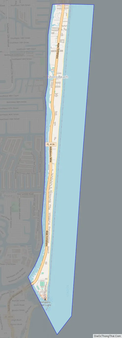
The 3.2-mile (5.1 km) strip along Florida State Road A1A is officially known as “Hillsboro Mile” in the town’s boundaries, and it’s the only main road in town. Because this is the only main public road, it is aligned with the residents’ mansions and commonly called “Millionaires’ Mile” by both local residents and visitors alike.
Since the town’s earliest years, the population doubles during wintertime.
Hillsboro Beach Road Map
Hillsboro Beach city Satellite Map

Geography
Hillsboro Beach is located at 26°17′38″N 80°4′42″W / 26.29389°N 80.07833°W / 26.29389; -80.07833 (26.293857, –80.078243). It is located in northeastern Broward County, along the Atlantic Ocean. It is on south end of the barrier island locally known as Deerfield Beach Island or Deerfield Cay.
It is adjacent to the following municipalities:
To its north:
To its west:
- Lighthouse Point (across the Intracoastal Waterway)
To its south:
To its east:
- Atlantic Ocean
According to the United States Census Bureau, the town has a total area of 1.5 square miles (3.8 km), of which 0.35 square miles (0.9 km) is land and 1.1 square miles (2.8 km) (74.87%) is water.
See also
Map of Florida State and its subdivision:- Alachua
- Baker
- Bay
- Bradford
- Brevard
- Broward
- Calhoun
- Charlotte
- Citrus
- Clay
- Collier
- Columbia
- Desoto
- Dixie
- Duval
- Escambia
- Flagler
- Franklin
- Gadsden
- Gilchrist
- Glades
- Gulf
- Hamilton
- Hardee
- Hendry
- Hernando
- Highlands
- Hillsborough
- Holmes
- Indian River
- Jackson
- Jefferson
- Lafayette
- Lake
- Lee
- Leon
- Levy
- Liberty
- Madison
- Manatee
- Marion
- Martin
- Miami-Dade
- Monroe
- Nassau
- Okaloosa
- Okeechobee
- Orange
- Osceola
- Palm Beach
- Pasco
- Pinellas
- Polk
- Putnam
- Saint Johns
- Saint Lucie
- Santa Rosa
- Sarasota
- Seminole
- Sumter
- Suwannee
- Taylor
- Union
- Volusia
- Wakulla
- Walton
- Washington
- Alabama
- Alaska
- Arizona
- Arkansas
- California
- Colorado
- Connecticut
- Delaware
- District of Columbia
- Florida
- Georgia
- Hawaii
- Idaho
- Illinois
- Indiana
- Iowa
- Kansas
- Kentucky
- Louisiana
- Maine
- Maryland
- Massachusetts
- Michigan
- Minnesota
- Mississippi
- Missouri
- Montana
- Nebraska
- Nevada
- New Hampshire
- New Jersey
- New Mexico
- New York
- North Carolina
- North Dakota
- Ohio
- Oklahoma
- Oregon
- Pennsylvania
- Rhode Island
- South Carolina
- South Dakota
- Tennessee
- Texas
- Utah
- Vermont
- Virginia
- Washington
- West Virginia
- Wisconsin
- Wyoming


