Weston is a city in Broward County, Florida, United States, just west of Fort Lauderdale. It is part of the Miami metropolitan area, which is anchored by Miami. The population was 68,107 at the 2020 census. Weston is 30 miles northwest of Miami, Florida.
| Name: | Weston city |
|---|---|
| LSAD Code: | 25 |
| LSAD Description: | city (suffix) |
| State: | Florida |
| County: | Broward County |
| Incorporated: | September 3, 1996 |
| Elevation: | 9 ft (3 m) |
| Land Area: | 24.59 sq mi (63.70 km²) |
| Water Area: | 1.51 sq mi (3.91 km²) |
| Population Density: | 2,769.37/sq mi (1,069.27/km²) |
| ZIP code: | 33326-33327, 33331-33332 |
| FIPS code: | 1276582 |
| GNISfeature ID: | 1761599 |
| Website: | www.westonfl.org |
Online Interactive Map
Click on ![]() to view map in "full screen" mode.
to view map in "full screen" mode.
Weston location map. Where is Weston city?


History
In the 1950s, industrialist and philanthropist Arthur Vining Davis took control of the approximately 15,000 acres (6,100 ha) which Weston is now located on; Davis was Arvida’s first owner. In the following years, plans were made to develop the land, and the area which is known as Bonaventure was sold and subsequently developed independently from the Arvida development; this area forms Weston’s Bonaventure Development District. The large, remaining portion of the master-planned community was developed by Arvida/JMB Realty (known for developing Walt Disney World), and the community was originally named Indian Trace; the area developed by Arvida forms Weston’s Indian Trace Development District.
The community’s name of Indian Trace was changed to Weston in the early 1980s, and in 1984, the first homes in the Arvida-developed section of Weston were completed in the Country Isles and Windmill Ranch sections of the community.
In 1994, the Board of Supervisors of Weston began discussing the possibility of either incorporating as a municipality, being annexed into a neighboring municipality, or remaining an unincorporated area of Broward County. In April 1994, the Board of Supervisors initiated an Incorporation Feasibility Study, and a nine-member Steering committee consisting of residents and consultants was established by the Board.
By November 1995, after ruling out remaining an unincorporated area or being annexed to the neighboring municipalities of Davie, Fort Lauderdale, Pembroke Pines, or Sunrise (all four of which received Requests for Proposals on the matter from the Board of Supervisors), it was concluded by both the Board of Supervisors and the Steering Committee that the best option was for Weston to incorporate itself as a city. This was determined to be the best option because the community would be able to govern itself on a local level through home rule, and because the local tax revenues generated by the residents would stay in Weston, remain in Weston’s control, and be used by and for Weston. Shortly thereafter, the Board of Supervisors formally requested to the State of Florida to let the Indian Trace Development District’s residents vote on whether or not their district should incorporate as a city.
On May 6, 1996, the State Legislature approved the Local Bill, and a vote on the matter was subsequently scheduled for that summer. Weston ultimately incorporated itself as a city on September 3, 1996. Roughly 90% of the voters in voted in favor of incorporation.
The Bonaventure section was given the choice of becoming a part of Weston or a part of the City of Sunrise, located adjacent to Weston, as part of the Local Bill. On April 1, 1997, by a nearly two-to-one margin, the voters residing in the Bonaventure area voted in favor of becoming part of the City of Weston.
Weston Road Map

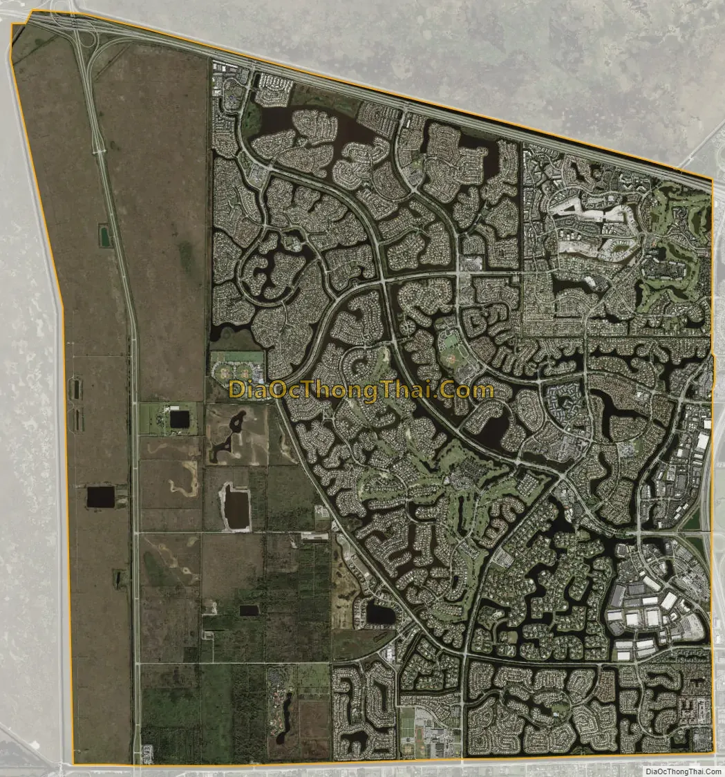
Weston city Satellite Map
Geography
According to the United States Census Bureau, the city has a total area of 26.3 square miles (68.2 km), of which 25.2 square miles (65.2 km) is land and 1.2 square miles (3.1 km) is water, or 4.49% of the total area.
Weston is bordered by Sunrise to the northeast, Davie to the east, Southwest Ranches to the south, and the Everglades to the north and west. It is the most western city in Broward County, and the entirety of its western edge is located next to the Everglades.
Weston consists of two development districts: the Bonaventure Development District and the Indian trace Development District.
Weston is located roughly 31 miles (50 km) to the northwest of Miami.
Climate
Weston has a tropical rainforest climate (Af). The weather is typically very humid and sunny during the majority of the year. Winters are usually dry and warm during La Niña conditions, while El Niño conditions usually bring cool and wet conditions to the region. ENSO effects on South Florida are rather minimal during the summer months, with the exception of tropical cyclone activity in the Atlantic Basin.
See also
Map of Florida State and its subdivision:- Alachua
- Baker
- Bay
- Bradford
- Brevard
- Broward
- Calhoun
- Charlotte
- Citrus
- Clay
- Collier
- Columbia
- Desoto
- Dixie
- Duval
- Escambia
- Flagler
- Franklin
- Gadsden
- Gilchrist
- Glades
- Gulf
- Hamilton
- Hardee
- Hendry
- Hernando
- Highlands
- Hillsborough
- Holmes
- Indian River
- Jackson
- Jefferson
- Lafayette
- Lake
- Lee
- Leon
- Levy
- Liberty
- Madison
- Manatee
- Marion
- Martin
- Miami-Dade
- Monroe
- Nassau
- Okaloosa
- Okeechobee
- Orange
- Osceola
- Palm Beach
- Pasco
- Pinellas
- Polk
- Putnam
- Saint Johns
- Saint Lucie
- Santa Rosa
- Sarasota
- Seminole
- Sumter
- Suwannee
- Taylor
- Union
- Volusia
- Wakulla
- Walton
- Washington
- Alabama
- Alaska
- Arizona
- Arkansas
- California
- Colorado
- Connecticut
- Delaware
- District of Columbia
- Florida
- Georgia
- Hawaii
- Idaho
- Illinois
- Indiana
- Iowa
- Kansas
- Kentucky
- Louisiana
- Maine
- Maryland
- Massachusetts
- Michigan
- Minnesota
- Mississippi
- Missouri
- Montana
- Nebraska
- Nevada
- New Hampshire
- New Jersey
- New Mexico
- New York
- North Carolina
- North Dakota
- Ohio
- Oklahoma
- Oregon
- Pennsylvania
- Rhode Island
- South Carolina
- South Dakota
- Tennessee
- Texas
- Utah
- Vermont
- Virginia
- Washington
- West Virginia
- Wisconsin
- Wyoming


