Powell is a city in the U.S. state of Ohio, located 14 miles (21.5 km) north of the state capital of Columbus. The city is located in Delaware County; a frequent placeholder on the List of highest-income counties in the United States, and 35th wealthiest county in the United States in 2020. Powell had an estimated population of 13,375 in 2019, up from 11,500 at the 2010 census. Founded in the early 1800s, it is now a growing suburb of Columbus. Per the U.S. Census Bureau, 73.5% of Powell residents over the age of 25 are college graduates, the median home value is $372,700, and the median household income is $157,149. In 2018, the median list price of a home within the City of Powell was $411,173.
| Name: | Powell city |
|---|---|
| LSAD Code: | 25 |
| LSAD Description: | city (suffix) |
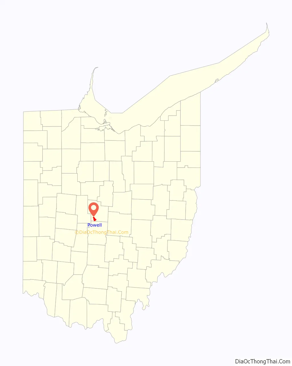
| State: | Ohio |
| County: | Delaware County |
| Founded: | 1801 |
| Incorporated: | 1947 |
| Elevation: | 909 ft (277 m) |
| Total Area: | 5.82 sq mi (15.07 km²) |
| Land Area: | 5.82 sq mi (15.06 km²) |
| Water Area: | 0.00 sq mi (0.01 km²) |
| Total Population: | 14,163 |
| Population Density: | 2,435.60/sq mi (940.35/km²) |
| ZIP code: | 43065 |
| Area code: | 614, 740 |
| FIPS code: | 3964486 |
| GNISfeature ID: | 1061569 |
| Website: | www.cityofpowell.us |
Online Interactive Map
Click on ![]() to view map in "full screen" mode.
to view map in "full screen" mode.
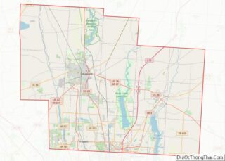
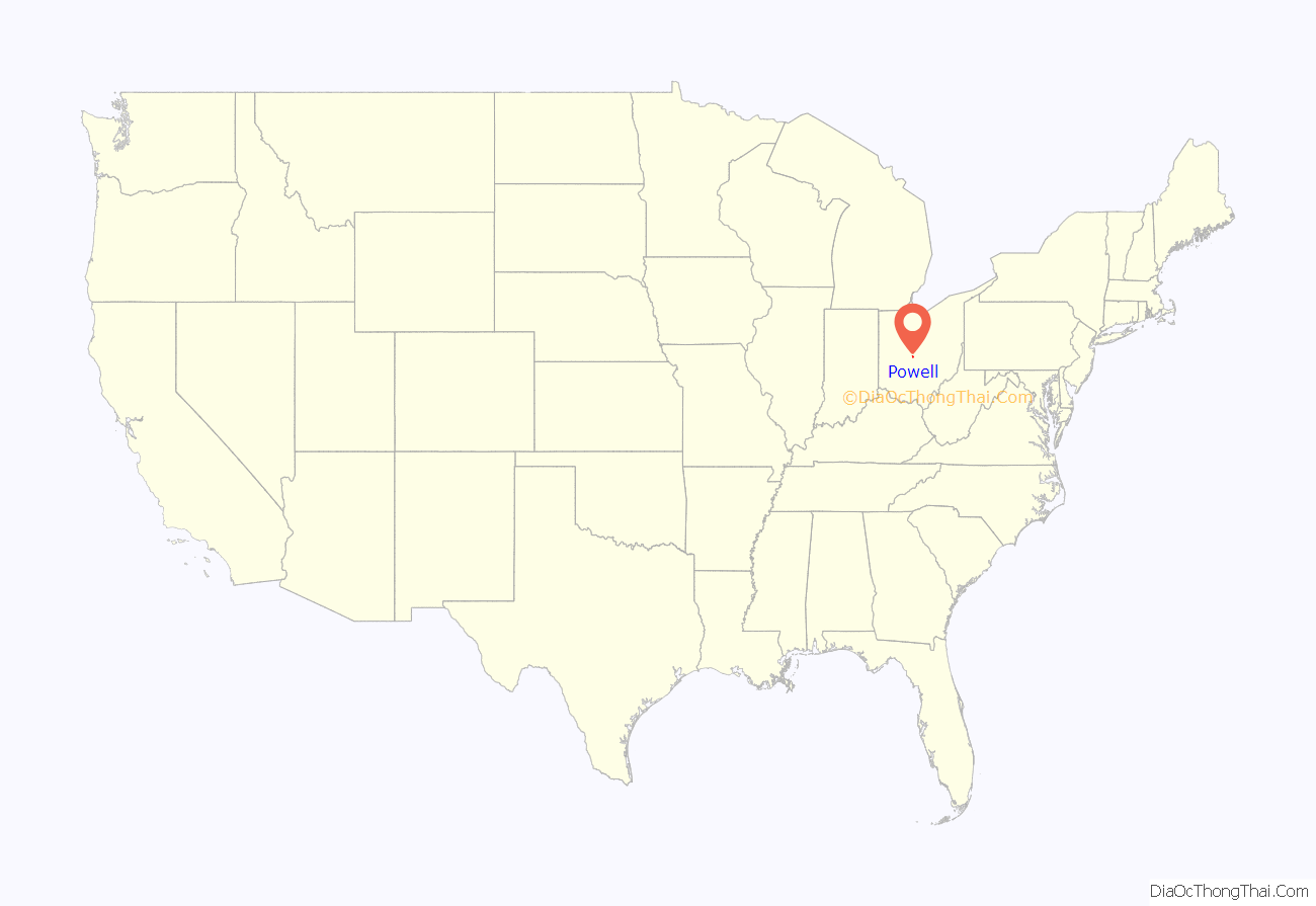
Powell location map. Where is Powell city?
History
Early history
Present-day Powell is located on land that was once a vast wilderness sparsely populated by Native Americans including the Huron, Wyandot, Miami, Delaware, Ottawa, Shawnee, Mingo, and Erie people. The region was surveyed by French Canadian and European explorers beginning in the 17th century; with Great Britain, France, and the Iroquois League claiming ownership of the land during periods of the 1600s and 1700s. By the 18th century, the land became part of that what is historically known as Ohio Country. During the American Revolution, the states of Connecticut, New York, Pennsylvania, and Virginia claimed portions of the land during western expansion of the United States. The Land Ordinance of 1785 opened up the region to settlement by American pioneers, including veterans of the American Revolutionary War who had received bounty land warrants as compensation for their services. In 1787, the region was established as the Northwest Territory.
Settlement and growth
The first settlers arrived in present-day Powell on May 1, 1801. At the time, the land was deeded to Thomas R. Hall. By 1813, records indicate that the settlement became known as “Middlebury”, in possible reference to early settlers having come from Middlebury, Connecticut. Today, Powell maintains references to its heritage as Middlebury with multiple streets and housing developments applying the name.
The population of Middlebury remained small, with historical records suggesting that settlers held trades and occupations consistent with other small towns of time period. The settlement included farmers, milliners, buggy makers, and blacksmiths. In 1839, deed owner Thomas R. Hall purchased additional nearby land, and later opened a general store. Middlebury was renamed for him in 1850, becoming “Hall’s Corner”. According to historical records, a variant of this new name has been recorded as “Hall Corners”. In 1857, Hall’s Corner applied for an official post office, which required the approval of a judge. The village was renamed Powell in honor of the judge who approved the request.
The Columbus and Toledo Railroad (C&T) arrived in Powell in 1872, which provided new opportunities for settlers. The primary purpose of the railroad was to transport coal from Appalachia to regions beyond Columbus. After merging with two other railroads in 1899, C&T became part of the Hocking Valley Railway. As of 2021, much of the line still operates as the Columbus Subdivision freight line, owned by CSX Transportation.
Powell was finally incorporated as a municipality in 1947, and was later known as the Village of Powell. The population remained small until the late 1980s, when residential development expanding from the northern Columbus metropolitan area reached Powell. In 20 years, the population grew almost 1,500%, from 378 to over 6,000. In 2000, Powell officially became a city.
Between the years 2000 and 2010, Powell’s population nearly doubled again, largely due to the 2002 annexation of approximately 1,000 acres along the Sawmill Parkway extension north of Seldom Seen Road for the development of the Golf Village community.
Liberty Township Separation Movement of 1995
On February 21, 1995, Powell Village Council members voted 5-1 in favor of an ordinance requesting Delaware County Commissioners withdraw the Village of Powell from Liberty Township, with Councilman Bill Nolan dissenting. The decision was made without soliciting a community vote, which prompted residents to mount a referendum drive in hope of placing the separation issue on the November ballot. The separation of Powell from Liberty Township would have left the Village without fire department services, and would have impacted master planning efforts of the community. Proponents of the separation insisted that Liberty Township was too dependent on inside millage; the approximately $95,000 yearly that Powell residents were paying into Liberty Township’s general fund.
Powell Village residents needed 74 signatures to place the issue on the November ballot. A group of residents from The Chase and The Retreat subdivisions collected 179 signatures and submitted them to village clerk Doris Moore, on March 8, 1995. However, the Village Council refused the petition, citing a technicality with Ohio Revised Code section 731.32. Dan Boyle, organizer of the referendum movement and then president of The Chase Homeowner’s Association, insisted that the petition had been properly executed according to local charter section 6.10, entitled “Initiative and Referendum Petition Procedures.”
Following the Council’s decision to refuse the petition, Powell resident and attorney Lawrence Walker urged Delaware County Commissioner W. Duncan Whitney and Powell Mayor Jane VanFossen to take action. Mayor VanFossen ultimately decided that the Clerk of Council failed to perform her obligation of processing the petition, an action that therefore voided the separation legislation of the Council; Ordinance No. 93-54. Due to significant public interest generated in the wake of the petition, Powell’s Village Council agreed to place the issue on the ballot of the August 8 special election. Of the 384 residents in Powell that voted on the separation, 98 (26%) voted for the separation, and 286 (74%) voted against the separation. Powell was subsequently not removed from the Township, and an amicable relationship between the City of Powell and Liberty Township has continued ever since.
Powell Liberty Historical Society
The Powell Liberty Historical Society (PLHS) was formed in 1986 during a successful effort to save an 1889 farm house amid a rapid influx of housing developments. Local residents Louise Cornish and Janet Masteller led the campaign to save and restore the 1889 home; considered to be an example of midwestern architecture of the late 19th century. The house is called the Martin-Perry House, in honor of the only two families to have lived in the home. PLHS is located on Powell Road at Grace Drive, and has been open for tours since 1990. The society is a non-profit, volunteer organization that preserves the history of Powell and Liberty Township.
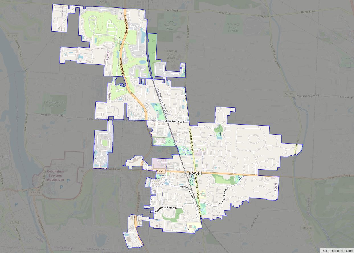
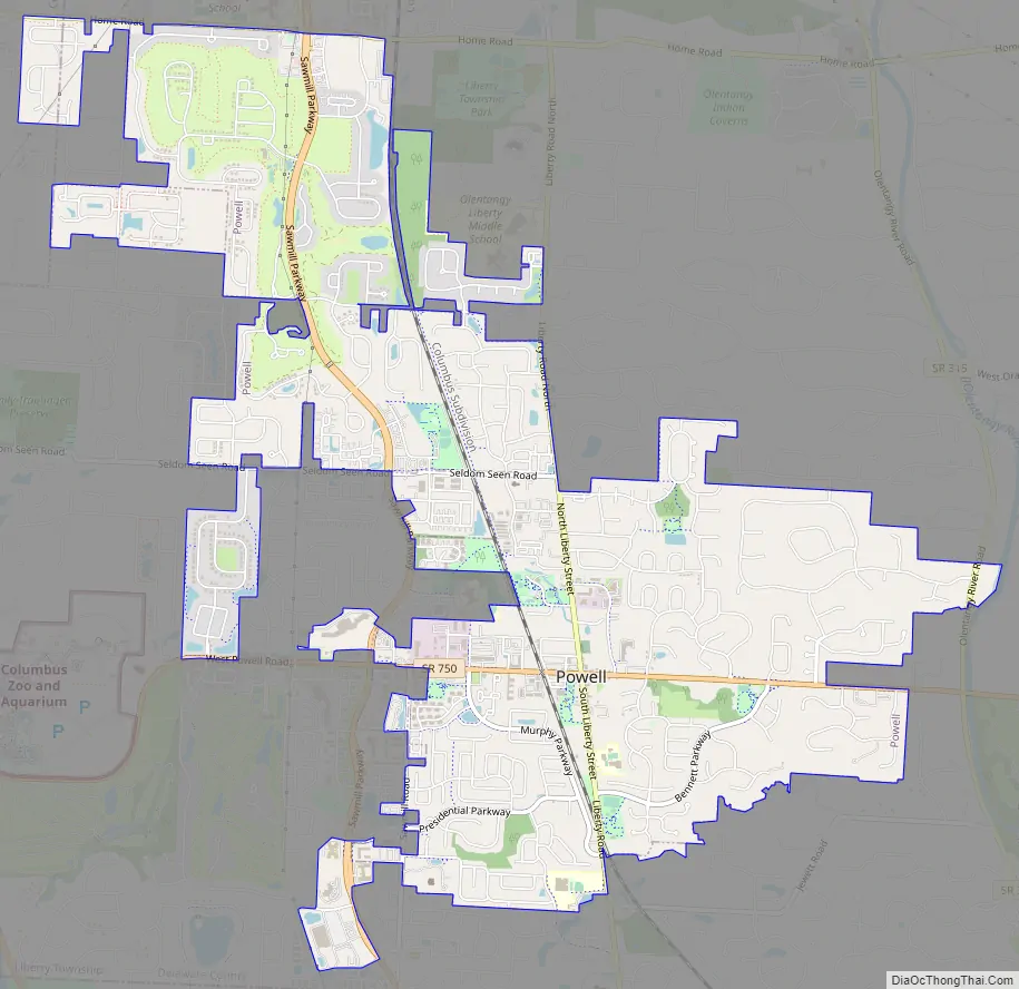
Powell Road Map
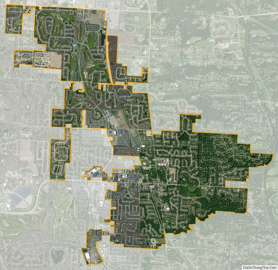
Powell city Satellite Map
Geography
Powell is located at 40°09′30″N 83°04′27″W / 40.158217°N 83.074252°W / 40.158217; -83.074252. The city sits between the Scioto and Olentangy Rivers, about 14 miles (21.5 km) north of the state capital of Columbus, centered on the intersection of State Route 750 and C.R.9; known as Liberty Street within the City of Powell. This intersection is commonly referred to by residents as the Four Corners. It sits within Liberty Township, the site of the first settlement in Delaware County, Ohio. According to the United States Census Bureau, the city has a total area of 4.93 square miles (12.77 km), all land.
See also
Map of Ohio State and its subdivision:- Adams
- Allen
- Ashland
- Ashtabula
- Athens
- Auglaize
- Belmont
- Brown
- Butler
- Carroll
- Champaign
- Clark
- Clermont
- Clinton
- Columbiana
- Coshocton
- Crawford
- Cuyahoga
- Darke
- Defiance
- Delaware
- Erie
- Fairfield
- Fayette
- Franklin
- Fulton
- Gallia
- Geauga
- Greene
- Guernsey
- Hamilton
- Hancock
- Hardin
- Harrison
- Henry
- Highland
- Hocking
- Holmes
- Huron
- Jackson
- Jefferson
- Knox
- Lake
- Lake Erie
- Lawrence
- Licking
- Logan
- Lorain
- Lucas
- Madison
- Mahoning
- Marion
- Medina
- Meigs
- Mercer
- Miami
- Monroe
- Montgomery
- Morgan
- Morrow
- Muskingum
- Noble
- Ottawa
- Paulding
- Perry
- Pickaway
- Pike
- Portage
- Preble
- Putnam
- Richland
- Ross
- Sandusky
- Scioto
- Seneca
- Shelby
- Stark
- Summit
- Trumbull
- Tuscarawas
- Union
- Van Wert
- Vinton
- Warren
- Washington
- Wayne
- Williams
- Wood
- Wyandot
- Alabama
- Alaska
- Arizona
- Arkansas
- California
- Colorado
- Connecticut
- Delaware
- District of Columbia
- Florida
- Georgia
- Hawaii
- Idaho
- Illinois
- Indiana
- Iowa
- Kansas
- Kentucky
- Louisiana
- Maine
- Maryland
- Massachusetts
- Michigan
- Minnesota
- Mississippi
- Missouri
- Montana
- Nebraska
- Nevada
- New Hampshire
- New Jersey
- New Mexico
- New York
- North Carolina
- North Dakota
- Ohio
- Oklahoma
- Oregon
- Pennsylvania
- Rhode Island
- South Carolina
- South Dakota
- Tennessee
- Texas
- Utah
- Vermont
- Virginia
- Washington
- West Virginia
- Wisconsin
- Wyoming