Windham is a village in eastern Portage County, Ohio, United States. The population was 1,666 at the 2020 census. In 1942, the U.S. government chose Windham as the site of an army camp for workers at the newly built Ravenna Arsenal. As a result, Windham experienced the largest increase in population of any municipality in the nation over the 1940s, at 1,148.7%.
Windham is officially considered part of Akron metropolitan area; however, it is slightly closer to Youngstown than Akron and significantly closer to Warren at 12.8 miles (20.6 km) away, even closer than the county seat of Ravenna. Due to this, the village also positions itself in relation to cities in the Mahoning Valley. Accordingly, the sole bank in Windham holds membership in the Youngstown-Warren Regional Chamber of Commerce.
| Name: | Windham village |
|---|---|
| LSAD Code: | 47 |
| LSAD Description: | village (suffix) |
| State: | Ohio |
| County: | Portage County |
| Total Area: | 2.06 sq mi (5.33 km²) |
| Land Area: | 2.06 sq mi (5.33 km²) |
| Water Area: | 0.00 sq mi (0.01 km²) |
| Total Population: | 1,666 |
| Population Density: | 809.92/sq mi (312.69/km²) |
| ZIP code: | 44288 |
| Area code: | 330, 234 |
| FIPS code: | 3985946 |
| Website: | windhamvillage.com |
Online Interactive Map
Click on ![]() to view map in "full screen" mode.
to view map in "full screen" mode.
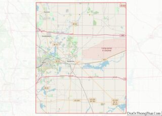
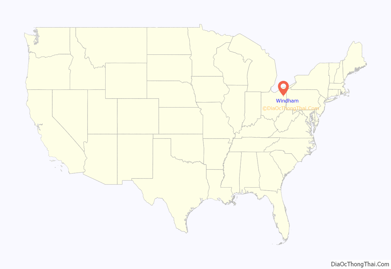
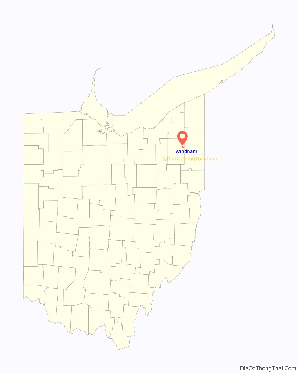
Windham location map. Where is Windham village?
History
Prior to 1811, the land now comprising the Village and Township of Windham was owned by Caleb Strong, as part of his holdings through the Ohio Company of Associates. On September 11, 1810, a group of sixteen men met in Becket, Massachusetts at the home of Thatcher Conant to discuss the purchase of land in Ohio for settlement. These men, who would be known as the Beckett [sic] Land Company, consisted of Conant, Elijah Alford, Nathan Birchard, Gideon Bush, Dillingham Clark, Elisha Clark, Isaac Clark, Benjamin Higley, Aaron P. Jagger, Enos Kingsley, Jeremiah Lyman, Bille Messenger, Ebenezer Messenger, Benjamin C. Perkins, John Seely, and Alpheus Streator.
On November 11, 1810, the Beckett Land Company purchased about 14,825 acres (59.99 km) from Caleb Strong. The land was divided into 100 lots, and allotted according to each family’s investment in the company. Conant, his wife Elizabeth, Dillingham and Abigail Clark, and Alpheus and Anna Streator donated portions of their allotments near the center of the township for a village green, which was common practice for townships in the Connecticut Western Reserve. The group of sixteen families then departed from Massachusetts on May 2, 1811. Six weeks later, they arrived in the purchased survey township, which was located immediately south of Nelson Township in the Connecticut Western Reserve. This new township, known today as Windham Township, was survey town 4 in range 6 of the Western Reserve.
The first religious service in the new township was held on July 28, 1811, in the home of one of the settlers. This service was very likely Congregationalist, as several of the families belonged to the Congregational Church in Becket, Massachusetts. The Congregational Church eventually constructed a building on the Green, and today that church still remains on the Green as a member church of the United Church of Christ.
The Windham Historical Society notes that the township was originally named Strongsburg, however, some sources cite the original name as Strongsburgh. The namesake was original landowner Caleb Strong, who was by then the Governor of Massachusetts. There is some discrepancy in how this township came to be known as Windham. According to the Windham Historical Society, the name of the township “was changed to Sharon, by an act of legislature in about 1820…. A few years later the name was again changed to Windham, which it has remained to present.” The Historical Society also cites political concerns as the reason the name was changed from Strongsburg to Sharon. However, on Windham Township’s website, March 2, 1813 is cited as the date on which “the Township was made a district by itself and the name was changed to ‘Sharon’.” The website goes on to state that in 1820, by an act of legislature, the name was changed again to Windham. Yet another source, The Ohio Gazetteer, and Travelers’s [sic] Guide, states that the name was changed from Sharon to Windham in January, 1829. Still another source places these dates as 1817 and 1820, respectively. Common to most sources are a few claims which reasonably can be ascertained to be fact:
- Caleb Strong was the original namesake of the township.
- The name of the township was changed from Strongsburg/Strongsburgh, to Sharon, and again to Windham.
- The second name change, from Sharon to Windham, was in honor of Windham, Connecticut—home to at least some of the township’s original settlers.
On November 22, 1973 a train heading eastbound at 50 mph derailed to a switch being open to an industrial track. Two locomotives and the 12 first twelve cars derailed. The engineer Raymond Wilcox passed away in the accident. During the investigation it was discovered that two juveniles admitted to placing the switch into the reverse direction.
The Village of Windham was incorporated in 1892, and on October 12, 1993 the village officially withdrew from Windham Township.
Ravenna Arsenal
In 1940, the United States Department of the Army reserved 21,418 acres (86.68 km) in eastern Portage County for the construction of two facilities One of these was the Portage Ordnance Depot, which with its twin facility the Ravenna Ordnance Plant became known as the Ravenna Arsenal. Over 14,000 people were employed at the Arsenal during World War II, and the village of Windham was chosen as the site to house many of these workers. Windham experienced a population boom as a result; its growth of over 1100% was the largest of any U.S. municipality in the 1950 Census, as was reported in the June 1951 edition of National Geographic magazine.
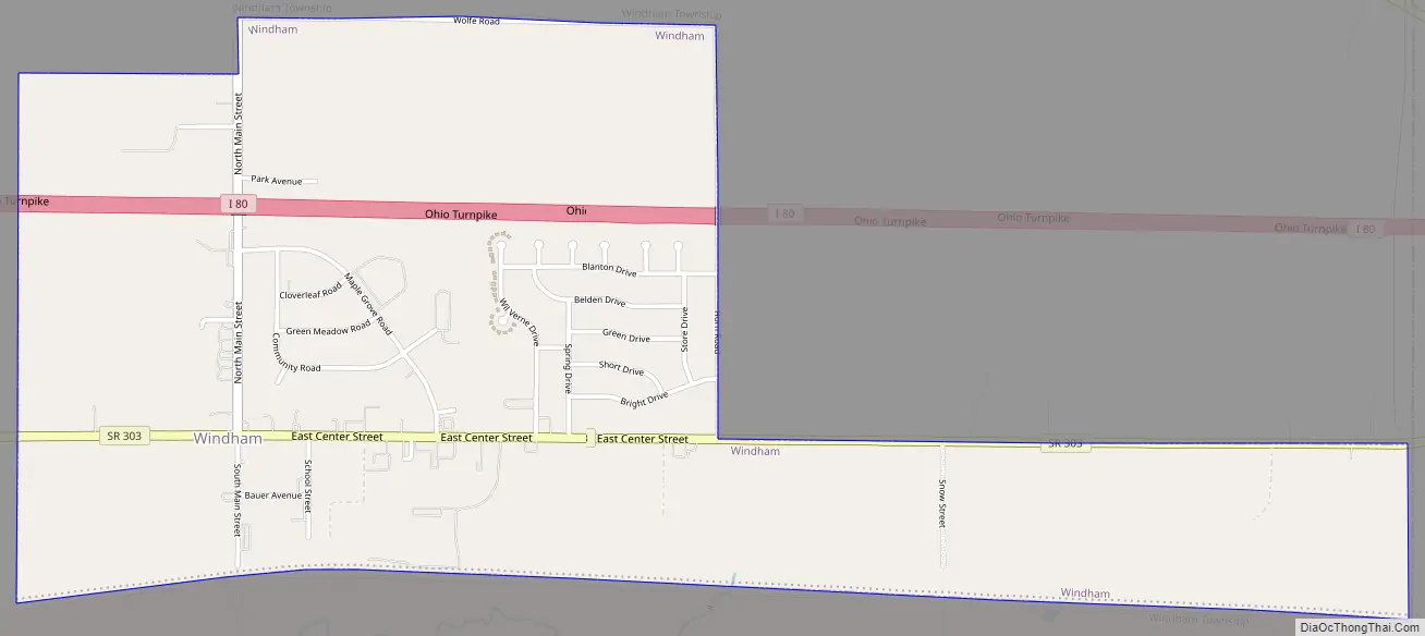
Windham Road Map
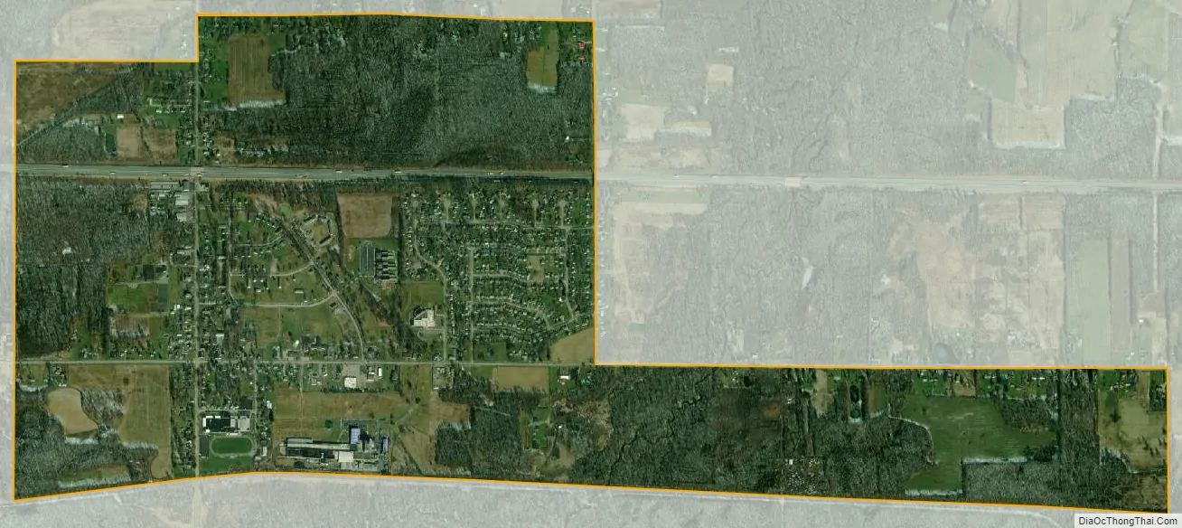
Windham city Satellite Map
Geography
According to the United States Census Bureau, the village has a total area of 2.06 square miles (5.34 km), all land. Interstate 80 and the Ohio Turnpike pass through the village, although there is presently no interchange in either Windham or Windham Township. Windham’s location on the toll highway, however, has in recent years caused an expansion of 3G wireless communication services for the people of Windham.
See also
Map of Ohio State and its subdivision:- Adams
- Allen
- Ashland
- Ashtabula
- Athens
- Auglaize
- Belmont
- Brown
- Butler
- Carroll
- Champaign
- Clark
- Clermont
- Clinton
- Columbiana
- Coshocton
- Crawford
- Cuyahoga
- Darke
- Defiance
- Delaware
- Erie
- Fairfield
- Fayette
- Franklin
- Fulton
- Gallia
- Geauga
- Greene
- Guernsey
- Hamilton
- Hancock
- Hardin
- Harrison
- Henry
- Highland
- Hocking
- Holmes
- Huron
- Jackson
- Jefferson
- Knox
- Lake
- Lake Erie
- Lawrence
- Licking
- Logan
- Lorain
- Lucas
- Madison
- Mahoning
- Marion
- Medina
- Meigs
- Mercer
- Miami
- Monroe
- Montgomery
- Morgan
- Morrow
- Muskingum
- Noble
- Ottawa
- Paulding
- Perry
- Pickaway
- Pike
- Portage
- Preble
- Putnam
- Richland
- Ross
- Sandusky
- Scioto
- Seneca
- Shelby
- Stark
- Summit
- Trumbull
- Tuscarawas
- Union
- Van Wert
- Vinton
- Warren
- Washington
- Wayne
- Williams
- Wood
- Wyandot
- Alabama
- Alaska
- Arizona
- Arkansas
- California
- Colorado
- Connecticut
- Delaware
- District of Columbia
- Florida
- Georgia
- Hawaii
- Idaho
- Illinois
- Indiana
- Iowa
- Kansas
- Kentucky
- Louisiana
- Maine
- Maryland
- Massachusetts
- Michigan
- Minnesota
- Mississippi
- Missouri
- Montana
- Nebraska
- Nevada
- New Hampshire
- New Jersey
- New Mexico
- New York
- North Carolina
- North Dakota
- Ohio
- Oklahoma
- Oregon
- Pennsylvania
- Rhode Island
- South Carolina
- South Dakota
- Tennessee
- Texas
- Utah
- Vermont
- Virginia
- Washington
- West Virginia
- Wisconsin
- Wyoming