Beverly Hills is a city located in Los Angeles County, California. A notable and historic suburb of Los Angeles, it is located immediately southwest of the Hollywood Hills, approximately 12.2 miles (19.6 km) northwest of downtown Los Angeles. Beverly Hills’ land area totals to 5.71 square miles (14.8 km), and along with the smaller city of West Hollywood in the east, is almost entirely surrounded by the city of Los Angeles. According to the 2020 census, the city has a population of 32,701; marking a decrease of 1,408 from the 2010 census count of 34,109.
In American popular culture, Beverly Hills has been known primarily as an affluent location within Greater Los Angeles, which corresponds to higher property values and taxes in the area. The city is well known for its Rodeo Drive shopping district that includes many designer brands. Throughout its history, the city has been home to many celebrities. It is also home to numerous hotels and resorts, including the Beverly Hilton and the Beverly Hills Hotel. The city has been featured in many movies, television series, music and media, in the United States and internationally.
After its initial settlement in 1828, Beverly Hills first developed primarily as an agricultural community, originally centered around Rancho Rodeo de las Aguas, a Mexican era rancho grant. Beverly Hills was first incorporated as a city in September 1914 by a group of investors who had failed to find oil but found water instead and eventually decided to develop it into a town.
| Name: | Beverly Hills city |
|---|---|
| LSAD Code: | 25 |
| LSAD Description: | city (suffix) |
| State: | California |
| County: | Los Angeles County |
| Incorporated: | January 28, 1914 |
| Elevation: | 259 ft (79 m) |
| Total Area: | 5.71 sq mi (14.79 km²) |
| Land Area: | 5.71 sq mi (14.78 km²) |
| Water Area: | 0.00 sq mi (0.00 km²) 0.04% |
| Total Population: | 32,701 |
| Population Density: | 5,728.98/sq mi (2,212.00/km²) |
| ZIP code: | 90209–90213 |
| FIPS code: | 0606308 |
| Website: | www.beverlyhills.org |
Online Interactive Map
Click on ![]() to view map in "full screen" mode.
to view map in "full screen" mode.
Beverly Hills location map. Where is Beverly Hills city?


History
Early history
Gaspar de Portolá arrived in the area that would later become Beverly Hills on August 3, 1769, traveling along native trails which followed the present-day route of Wilshire Boulevard. The area was settled by Maria Rita Quinteros de Valdez and her husband in 1828. They called their 4,500 acres (18 km) of property the Rancho Rodeo de las Aguas. In 1854, she sold the ranch to Benjamin Davis Wilson (1811–1878) and Henry Hancock (1822–1883). By the 1880s, the ranch had been subdivided into parcels of 75 acres (0.30 km) and was being rapidly bought up by Anglos from Los Angeles and the East coast.
Henry Hammel and Andrew H. Denker acquired most of it and used it for farming lima beans. At this point, the area was known as the Hammel and Denker Ranch. By 1888, they were planning to build a town called Morocco on their holdings.
20th century
In 1900, Burton E. Green, Charles A. Canfield, Max Whittier, Frank H. Buck, Henry E. Huntington, William G. Kerckhoff, William F. Herrin, W.S. Porter and Frank H. Balch formed the Amalgamated Oil Company, bought the Hammel and Denker ranch, and began looking for oil. They did not find enough to exploit commercially by the standards of the time, though. In 1906, therefore, they reorganized as the Rodeo Land and Water Company, renamed the property “Beverly Hills”, subdivided it, and began selling lots. The development was named “Beverly Hills” after Beverly Farms in Beverly, Massachusetts, and because of the hills in the area.
The Los Angeles Times reported on September 2, 1906:
The first house in the subdivision was built in 1907, but sales remained slow.
Beverly Hills was one of many all-white planned communities started in the Los Angeles area around this time. Restrictive covenants prohibited non-whites from owning or renting property, unless they were employed as servants by white residents. It was also forbidden to sell or rent property to Jews in Beverly Hills.
Burton Green began construction on The Beverly Hills Hotel in 1911. The hotel was finished in 1912. The visitors drawn by the hotel were inclined to purchase land in Beverly Hills, and by 1914 the population had grown enough to qualify for incorporation as an independent city. That same year, the Rodeo Land and Water Company decided to separate its water business from its real estate business. The Beverly Hills Utility Commission was split off from the land company and incorporated in September 1914, buying all of the utilities-related assets from the Rodeo Land and Water Company.
In 1919, Douglas Fairbanks and Mary Pickford bought land on Summit Drive and built a mansion, finished in 1921 and nicknamed “Pickfair” by the press. The glamour associated with Fairbanks and Pickford as well as other movie stars who built mansions in the city contributed to its growing appeal.
By the early 1920s, the population of Beverly Hills had grown enough to make the water supply a political issue. In 1923, the usual solution, annexation to the city of Los Angeles, was proposed. There was considerable opposition to annexation among such famous residents as Pickford, Fairbanks, Will Rogers and Rudolph Valentino. The Beverly Hills Utility Commission, opposed to annexation as well, managed to force the city into a special election and the plan was defeated 337 to 507.
In 1928, the Beverly Wilshire Apartment Hotel (now the Beverly Wilshire Hotel) opened on Wilshire Boulevard between El Camino and Rodeo drives, part of the old Beverly Hills Speedway. That same year, oilman Edward L. Doheny finished construction of Greystone Mansion, a 55-room mansion meant as a wedding present for his son Edward L. Doheny, Jr. The house is now owned by the city of Beverly Hills and is a designated historical landmark.
In the early 1930s, Santa Monica Park was renamed Beverly Gardens and was extended to span the entire two-mile (3-kilometer) length of Santa Monica Boulevard through the city. The Electric Fountain marks the corner of Santa Monica Blvd. and Wilshire Blvd. with a small sculpture at the top of a Tongva kneeling in prayer. In April 1931, the new Italian Renaissance-style Beverly Hills City Hall was opened.
In the early 1940s, black actors and businessmen had begun to move into Beverly Hills, despite the covenants allowing only whites to live in the city. A neighborhood improvement association attempted to enforce the covenant in court. The defendants included prominent artists Hattie McDaniel, Louise Beavers, and Ethel Waters. Among the white residents supporting the lawsuit against blacks was Harold Lloyd, the silent film star. The NAACP participated in the defense, which was successful. In his decision, federal judge Thurmond Clarke said that it was time that “members of the Negro race are accorded, without reservations or evasions, the full rights guaranteed to them under the 14th amendment.” The United States Supreme Court declared restrictive covenants unenforceable in 1948 in Shelley v. Kraemer. A group of Jewish residents of Beverly Hills filed an amicus brief in this case.
In 1956, Paul Trousdale (1915–1990) purchased the grounds of the Doheny Ranch and developed it into the Trousdale Estates, convincing the city of Beverly Hills to annex it. The neighborhood has been home to Elvis Presley, Frank Sinatra, Dean Martin, Tony Curtis, Ray Charles, President Richard Nixon, as well as, in later years, Jennifer Aniston, David Spade, Vera Wang and John Rich.
In the late 1990s, the Los Angeles County Metropolitan Transportation Authority (LACMTA) proposed to build an extension of the Metro Red Line along Wilshire Boulevard and into Downtown Beverly Hills, but the city opposed it.
21st century
In 2001, LACMTA then proposed a bus rapid transit route down Santa Monica Blvd., but this was also opposed by the city and never built. This stretch of road is served by less efficient Metro Rapid buses using pre-existing roadways. By 2010, traffic in Beverly Hills and surrounding areas had deteriorated enough that the city’s habitual opposition had largely turned to support for subways within the city limits. As part of the Westside Subway Extension project, the D Line of the LA Metro Rail was intended in 2013 to be extended through Beverly Hills, adding two underground stations at Wilshire/La Cienega and Wilshire/Rodeo by the 2020s.
The city of Beverly Hills widely opposed Proposition 8, the 2008 ballot measure which repealed legal recognition of same-sex marriages. The proposition narrowly passed statewide, but in Beverly Hills, only 34% voted in favor, and 66% voted against it.
In the midst of the 2015 drought, Beverly Hills was found to be one of the largest water consumers in California. As a result, it was asked by the state to reduce consumption by 36%, prompting many residents to replace their lawns with native plants. Meanwhile, the city government replaced the grass in front of the City Hall with Mexican sage.
In September 2015, the City of Beverly Hills signed an agreement with Israel to work together on water use as well as “cybersecurity, public health, emergency services, disaster preparedness, public safety, counterterrorism and art and culture”.
In July 2016, the City of Beverly Hills received the Livability Award from the United States Conference of Mayors for its Ambassador Program, which takes care of the city’s homeless population.
The Beverly Hills Community Dog Park was dedicated on September 6, 2016.
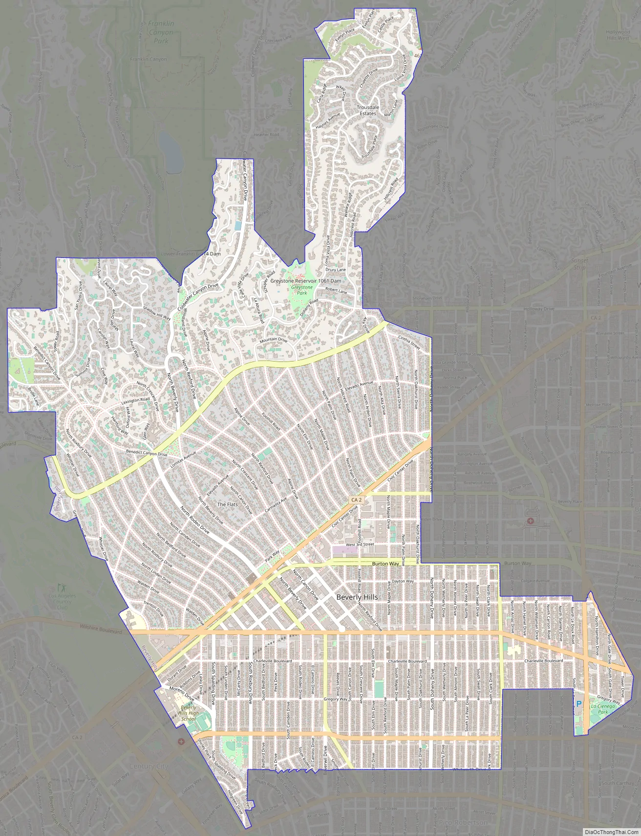
Beverly Hills Road Map
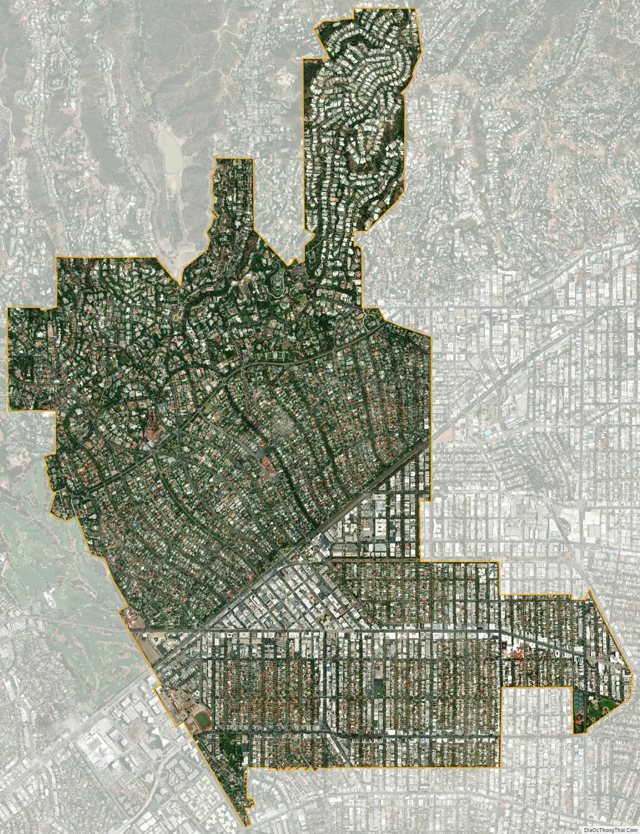
Beverly Hills city Satellite Map
Geography
Beverly Hills and the neighboring city of West Hollywood are together entirely surrounded by the city of Los Angeles. Beverly Hills is bordered on the northwest by the Los Angeles neighborhood of Bel-Air and the Santa Monica Mountains, on the east by West Hollywood, the Carthay neighborhood of Los Angeles, and the Fairfax District of Los Angeles, and on the south by the Beverlywood neighborhood of Los Angeles. The area’s “Platinum Triangle” is formed by the city of Beverly Hills and the Los Angeles neighborhoods of Bel Air and Holmby Hills.
The ZIP codes for Beverly Hills are 90209, 90210, 90211, 90212 and 90213.
Areas
Most residents live in the “flats” of Beverly Hills, which is a relatively flat area that slopes away from the hills, and includes all of Beverly Hills south of Sunset Boulevard and north of Santa Monica Boulevard.
In a triangle between Santa Monica Bl., Wilshire Bl. and Crescent Drive is Downtown Beverly Hills also known as the Golden Triangle, a retail and dining hub attracting locals, and in some sections attracting visitors from across the region and the world. The streets running northwest-to-southeast have distinct characters:
- Linden, Roxbury, Bedford and Camden drives, short streets catering to residents’ needs, lined with medical offices, bank branches, delicatessens, etc.
- Rodeo Drive, known for high-end boutiques;
- Beverly Drive, lined with upscale chain retailers commonly found in malls, such as Crate and Barrel, The Gap, Sephora, Pottery Barn, lululemon and Allsaints. Some restaurants line Beverly Drive as well.
- Cañon and Crescent drives, attracting local and regional shoppers and diners to restaurants such as Spago as well as local favorites, particularly along Cañon; but also catering to local needs, e.g. with a Rite Aid drugstore and a Whole Foods supermarket. Multi-story parking garages are also located along these streets.
- Wilshire Boulevard is lined with the two department stores remaining in the city: Saks Fifth Avenue, and Neiman Marcus. In the past, the upscale department stores Barneys New York, I. Magnin and J. W. Robinson’s all had important branches here.
South Beverly Drive, i.e. south of Wilshire Blvd., is another dining and shopping hub.
Houses south of Wilshire Boulevard have more urban square and rectangular lots, in general smaller than those to the north. There are also more apartment buildings south of Wilshire Boulevard than anywhere else in Beverly Hills.
Beverly Hills Post Office (BHPO) is the name given to a section directly north of the Beverly Hills city limits that lies within the 90210 ZIP code, assigned to the Beverly Hills Post Office, but is part of the City of Los Angeles.
Along with the Los Angeles communities of Bel-Air and Brentwood, Beverly Hills is one of the “Three Bs”, a wealthy area in the Los Angeles Westside.
Climate
Beverly Hills has a warm Mediterranean climate and receives an average 15 inches (380 mm) of rain per year. Summers are marked by warm to hot temperatures with very little wind, while winters are mild to moderate, with occasional rain alternating with periods of Santa Ana winds. Measurable snowfall has been recorded only in 1882, 1922, 1932, 1949 and 1958.
See also
Map of California State and its subdivision:- Alameda
- Alpine
- Amador
- Butte
- Calaveras
- Colusa
- Contra Costa
- Del Norte
- El Dorado
- Fresno
- Glenn
- Humboldt
- Imperial
- Inyo
- Kern
- Kings
- Lake
- Lassen
- Los Angeles
- Madera
- Marin
- Mariposa
- Mendocino
- Merced
- Modoc
- Mono
- Monterey
- Napa
- Nevada
- Orange
- Placer
- Plumas
- Riverside
- Sacramento
- San Benito
- San Bernardino
- San Diego
- San Francisco
- San Joaquin
- San Luis Obispo
- San Mateo
- Santa Barbara
- Santa Clara
- Santa Cruz
- Shasta
- Sierra
- Siskiyou
- Solano
- Sonoma
- Stanislaus
- Sutter
- Tehama
- Trinity
- Tulare
- Tuolumne
- Ventura
- Yolo
- Yuba
- Alabama
- Alaska
- Arizona
- Arkansas
- California
- Colorado
- Connecticut
- Delaware
- District of Columbia
- Florida
- Georgia
- Hawaii
- Idaho
- Illinois
- Indiana
- Iowa
- Kansas
- Kentucky
- Louisiana
- Maine
- Maryland
- Massachusetts
- Michigan
- Minnesota
- Mississippi
- Missouri
- Montana
- Nebraska
- Nevada
- New Hampshire
- New Jersey
- New Mexico
- New York
- North Carolina
- North Dakota
- Ohio
- Oklahoma
- Oregon
- Pennsylvania
- Rhode Island
- South Carolina
- South Dakota
- Tennessee
- Texas
- Utah
- Vermont
- Virginia
- Washington
- West Virginia
- Wisconsin
- Wyoming


