Fair Oaks is a census-designated place (CDP) in Sacramento County, California, United States. It is part of the Sacramento–Arden-Arcade–Roseville Metropolitan Statistical Area. The population was 32,514 at the 2020 census, up from 30,912 at the 2010 census. The Fair Oaks zip code is 95628 and its area codes are 916 and 279. It is bordered to the west by Carmichael, north by the city of Citrus Heights, to the east by Orangevale, and to the south by the American River.
| Name: | Fair Oaks CDP |
|---|---|
| LSAD Code: | 57 |
| LSAD Description: | CDP (suffix) |
| State: | California |
| County: | Sacramento County |
| Elevation: | 174 ft (53 m) |
| Total Area: | 11.245 sq mi (29.12 km²) |
| Land Area: | 10.793 sq mi (27.95 km²) |
| Water Area: | 0.452 sq mi (1.17 km²) 4.02% |
| Total Population: | 32,514 |
| ZIP code: | 95628 |
| Area code: | 916, 279 |
| FIPS code: | 0623294 |
Online Interactive Map
Click on ![]() to view map in "full screen" mode.
to view map in "full screen" mode.
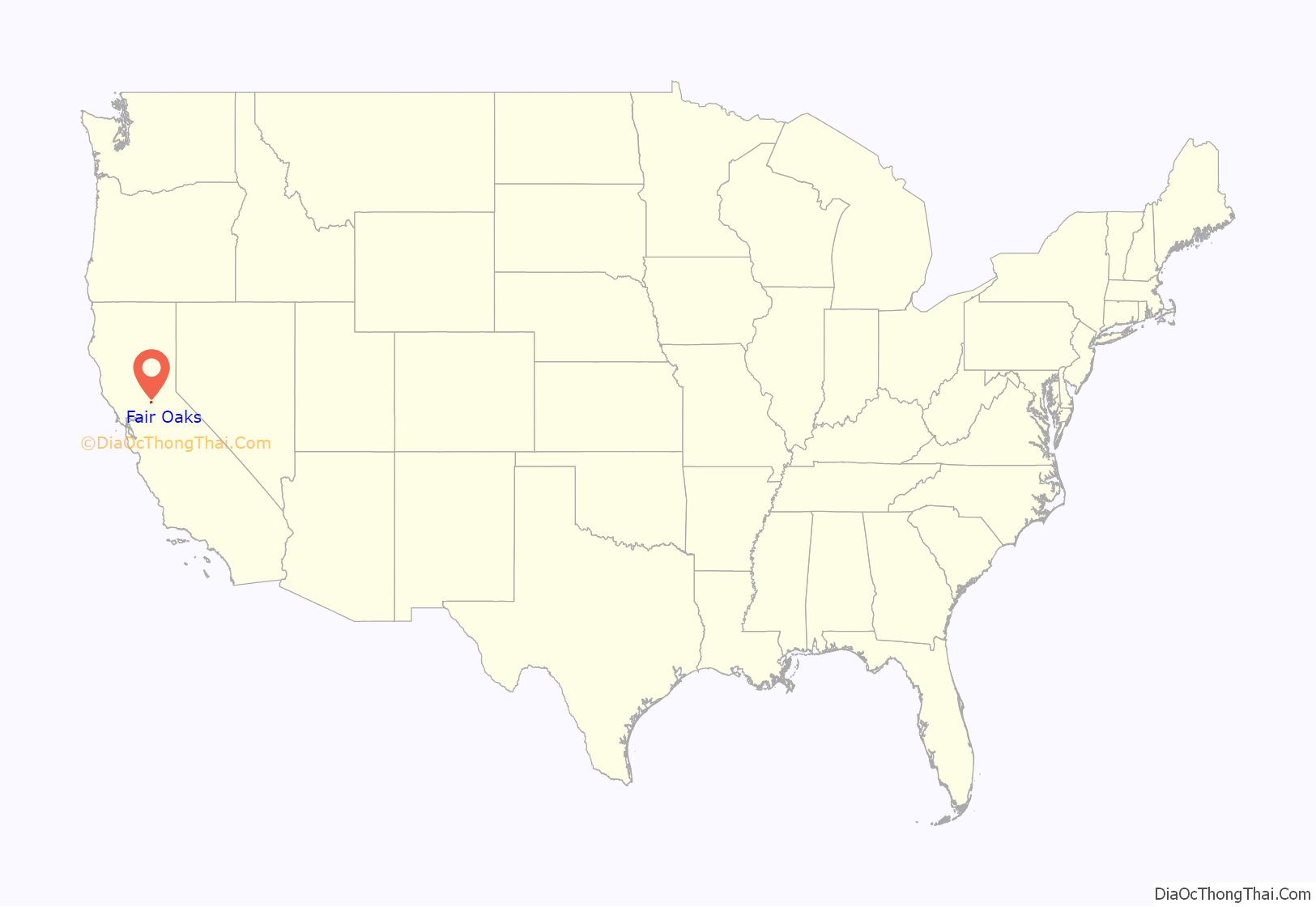
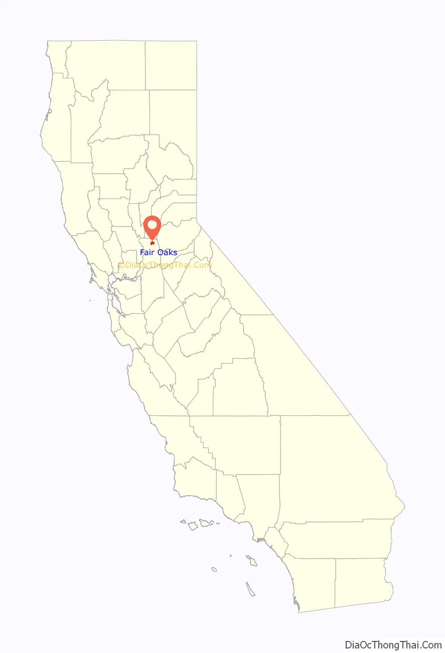
Fair Oaks location map. Where is Fair Oaks CDP?
History
19th century
The community began as part of the 1844 Rancho San Juan Mexican land grant. In 1895, Brevet Brigadier General Charles Henry Howard and James W. Wilson of the Howard-Wilson Publishing Company of Chicago acquired rights to present Fair Oaks community, then primarily covered by citrus farms, from California Senator Frederick K. Cox and businessman Crawford W. Clarke. The Howard-Wilson company surveyed and mapped the land and began to promote Fair Oaks as one of their “Sunset Colonies.” The Howard-Wilson company advertised Fair Oaks as an innovative and growing citrus colony after destructive freezes in Southern California and Florida and a national depression hitting in 1893. Many of the purchasers were professionals and other friends of the investors and the Fair Oaks community was initially composed primarily of businessmen and other professionals, including bankers and engineers.
In 1897, 300 permanent settlers lived in Fair Oaks, and purchased land in 5 to 20-acre tracts. Few farmers came to Fair Oaks, causing investment to diminish. This led to the Howard-Wilson Company withdrawing from the area. A club of businessmen in Chicago and Sacramento who had an investment (land or fruit) in the newborn colony and Orangevale formed the Chicago-Fair Oaks Club in 1899. They lobbied the government and other investors. They also helped in the construction of a bridge in Fair Oaks in 1901. Then a group of local businessmen, including Valentine S. McClatchy (the co-owner of the Sacramento Bee), incorporated the Fair Oaks Development Company in 1900. The boosters proclaimed Fair Oaks to be the “crown of the [Sacramento] valley,” in the “heart of California.”
Together these groups were able to succeed in constructing an efficient water supply. They convinced the Sacramento Chamber of Commerce, which McClatchy’s business partners from Orangevale created and chaired, to build a bridge across the American River at Fair Oaks in 1901. At the same time, the community leaders were also able to persuade the Southern Pacific Rail Road Company to build a railroad line to the bridge. Today, the bridge is known to locals as “The Red Bridge.” There is now a trail on the Northeast side of the bridge that people climb to sit on the cliffs high above the river and watch the sunset
20th century and growth
Fair Oaks grew rapidly with the completion of the Fair Oaks Bridge and the railroad line. The Fair Oaks Fruit Company incorporated in 1902 and built a warehouse in Fair Oaks to export not only citrus, but also almonds and olives. Also, in 1902, Dr. R. N. Bramhall became the first medical doctor to reside and set up office in Fair Oaks. The agricultural productivity attracted the development of other community services. Fair Oaks had become a typical small town by 1906 with a post office, hotel, blacksmith shop, lumber yard, pharmacy, bank, cemetery, newspaper, and a number of small dry-goods and grocery stores located along Main Street.
Two churches (Methodist and Presbyterian) were built and two schools (The Four Gables School and the Fair Oaks School—the current Community Clubhouse) appeared by 1910. The Fair Oaks Library Association formed in 1908 and constructed a permanent building in 1912. The Fair Oaks Civic Club purchased and developed the Plaza in 1918 for recreational and leisure activities. This plaza is still in use today.
Loss of the Citrus Crops
A big freeze hit in 1932 at the height of the Great Depression and many or most citrus groves were lost. After this and a similar freeze in 1934, Fair Oaks was no longer a major producer of citrus fruit in California. For the decades following and until the end of WWII, the Fair Oaks economy struggled to recover. In 1955, Aerojet, a rocket engine producing company, helped the Fair Oaks economy recover by bringing one of its new facilities nearby in what is now present-day Rancho Cordova. Some temporary dislocations occurred when employment at Aerojet dropped over 90% in the late 1960s and early 1970s. The growth rate still continued, however, because of the increased access to Sacramento by Highway 50 and the construction of the Sunrise Boulevard Bridge in 1954. This allowed both for residents of Fair Oaks to find greater employment in the connecting area and for Sacramentans to relocate to Fair Oaks more easily. The former citrus colony transformed into a bedroom community of greater Sacramento.
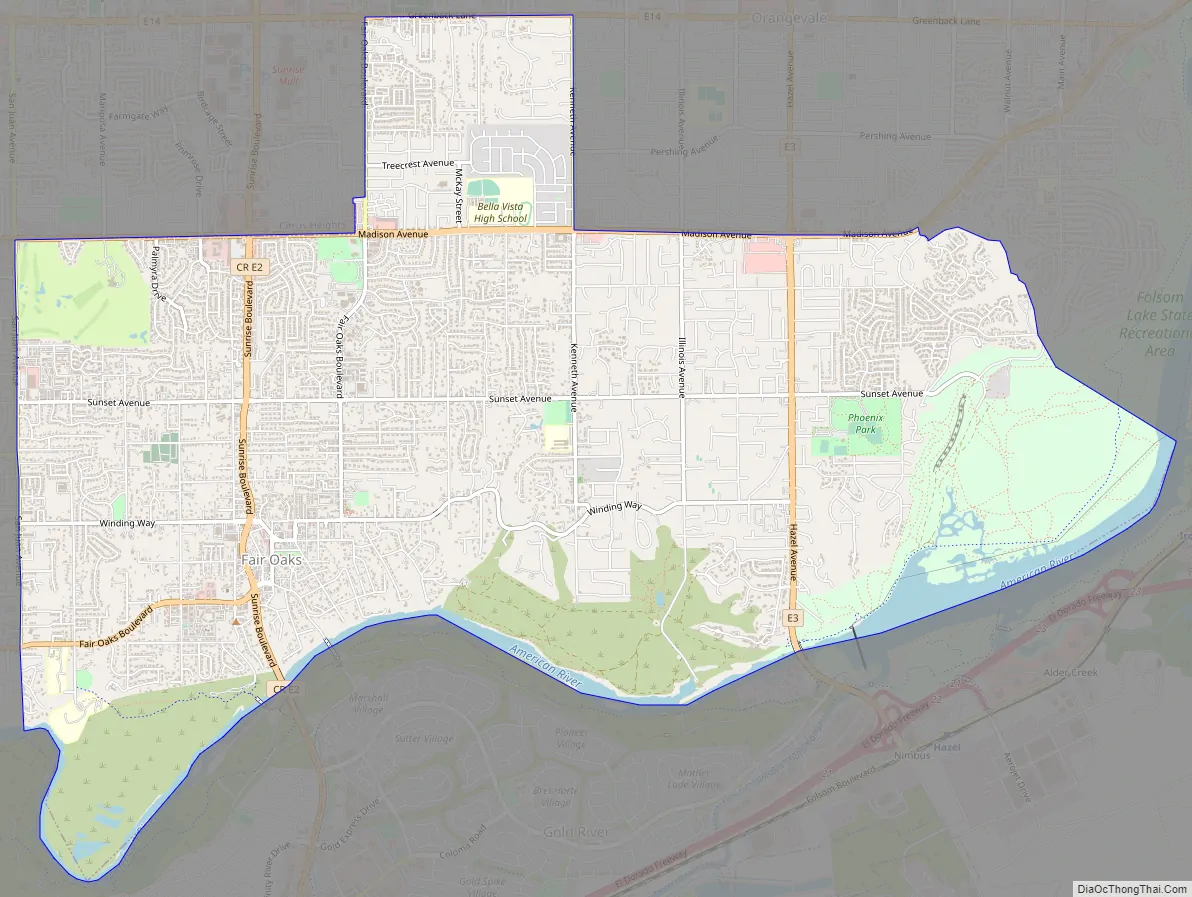
Fair Oaks Road Map
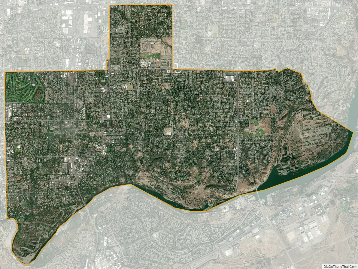
Fair Oaks city Satellite Map
Geography
Geography
Fair Oaks is a natural, lush foliage town with rolling streets, canopies of trees, located at 38°39′5″N 121°15′33″W / 38.65139°N 121.25917°W / 38.65139; -121.25917 (38.651254, -121.259279), between Sacramento and Folsom.
Fair Oaks is bounded on the south side by the American River, and Gold River, on the north side by the city of Citrus Heights, on the west side by Carmichael, and the east side by Orangevale and Folsom. Fair Oaks has a mix of upscale, custom home pocket areas, few apartments, and is a semi-rural neighborhood with easy access to Highway 50.
According to the United States Census Bureau, the CDP has a total area of 11.2 square miles (29 km), of which, 10.8 square miles (28 km) of it is land and 0.5 square miles (1.3 km) of it (4.02%) is water.
Climate
Fair Oaks has a hot-summer Mediterranean climate (Köppen Csa), characterized by damp to wet, mild winters and hot, dry summers.
The normal annual mean temperature is 61.0 °F (16.1 °C), with the monthly daily average temperature ranging from 46.4 °F (8.0 °C) in December to 75.5 °F (24.2 °C) in July. Summer heat is often moderated by a sea breeze known as the “delta breeze” which comes through the Sacramento–San Joaquin River Delta from the San Francisco Bay, and temperatures cool down sharply at night. On average, there are 73 days where the high exceeds 90 °F (32 °C), and 14 days where the high exceeds 100 °F (38 °C); On the other extreme, there are 15 days where the temperature does not exceed 50 °F (10 °C), and 15 freezing nights per year. The foggiest months are December and January. Tule fog can be extremely dense, lowering visibility to less than 100 feet (30 m) and making driving conditions extremely hazardous. Chilling tule fog events have been known to last for several consecutive days or weeks. During Tule fog events, temperatures do not exceed 50 degrees.
The average annual precipitation is 18.52 inches (470 mm). The wet season is generally October through April, though there may be a day or two of light rainfall in June or September. On average, precipitation falls on 60 days each year in Fair Oaks, and nearly all of this falls during the winter months. Average January rainfall is 3.67 in (93 mm), and measurable precipitation is rare during the summer months. On rare occasions, monsoonal moisture surges from the Desert Southwest can bring upper-level moisture to the Sacramento region, leading to increased summer cloudiness, humidity, and even light showers and thunderstorms. Monsoon clouds do occur, usually during late July through early September. This climate is suited to the endangered Sacramento Orcutt Grass, which has a protected reserve at the Phoenix Vernal Pools.
Snowfall is rare in Fair Oaks, which is only 174 ft (53 m) above sea level. During especially cold winter and spring storms, intense showers can produce a significant amount of hail, which can create hazardous driving conditions. Snowfall usually melts upon ground contact, with traceable amounts of snow occurring in some years.
See also
Map of California State and its subdivision:- Alameda
- Alpine
- Amador
- Butte
- Calaveras
- Colusa
- Contra Costa
- Del Norte
- El Dorado
- Fresno
- Glenn
- Humboldt
- Imperial
- Inyo
- Kern
- Kings
- Lake
- Lassen
- Los Angeles
- Madera
- Marin
- Mariposa
- Mendocino
- Merced
- Modoc
- Mono
- Monterey
- Napa
- Nevada
- Orange
- Placer
- Plumas
- Riverside
- Sacramento
- San Benito
- San Bernardino
- San Diego
- San Francisco
- San Joaquin
- San Luis Obispo
- San Mateo
- Santa Barbara
- Santa Clara
- Santa Cruz
- Shasta
- Sierra
- Siskiyou
- Solano
- Sonoma
- Stanislaus
- Sutter
- Tehama
- Trinity
- Tulare
- Tuolumne
- Ventura
- Yolo
- Yuba
- Alabama
- Alaska
- Arizona
- Arkansas
- California
- Colorado
- Connecticut
- Delaware
- District of Columbia
- Florida
- Georgia
- Hawaii
- Idaho
- Illinois
- Indiana
- Iowa
- Kansas
- Kentucky
- Louisiana
- Maine
- Maryland
- Massachusetts
- Michigan
- Minnesota
- Mississippi
- Missouri
- Montana
- Nebraska
- Nevada
- New Hampshire
- New Jersey
- New Mexico
- New York
- North Carolina
- North Dakota
- Ohio
- Oklahoma
- Oregon
- Pennsylvania
- Rhode Island
- South Carolina
- South Dakota
- Tennessee
- Texas
- Utah
- Vermont
- Virginia
- Washington
- West Virginia
- Wisconsin
- Wyoming


