Lancaster /ˈlæŋ.kæstər/ is a charter city in northern Los Angeles County, in the Antelope Valley of the western Mojave Desert in Southern California. As of the 2020 census, the population was 173,516, making Lancaster the 153rd largest city in the United States and the 30th largest in California. Lancaster is a twin city with its southern neighbor Palmdale; together, they are the principal cities within the Antelope Valley region.
Lancaster is located approximately 70 miles (110 km) north (via I-5 and SR 14) of downtown Los Angeles and is near the Kern County line. It is separated from the Los Angeles Basin by the San Gabriel Mountains to the south and from Bakersfield and the San Joaquin Valley by the Tehachapi Mountains to the north. The population of Lancaster has grown from 37,000 at the time of its incorporation in 1977 to over 157,000 as of 2019.
| Name: | Lancaster city |
|---|---|
| LSAD Code: | 25 |
| LSAD Description: | city (suffix) |
| State: | California |
| County: | Los Angeles County |
| Incorporated: | November 22, 1977 |
| Elevation: | 2,359 ft (719 m) |
| Total Area: | 94.54 sq mi (244.87 km²) |
| Land Area: | 94.28 sq mi (244.19 km²) |
| Water Area: | 0.26 sq mi (0.68 km²) 0.29% |
| Total Population: | 173,516 |
| Population Density: | 1,835/sq mi (645.41/km²) |
| Area code: | 661 |
| FIPS code: | 0640130 |
| Website: | www.cityoflancasterca.org |
Online Interactive Map
Click on ![]() to view map in "full screen" mode.
to view map in "full screen" mode.
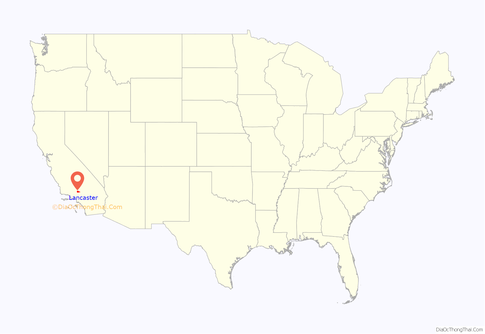
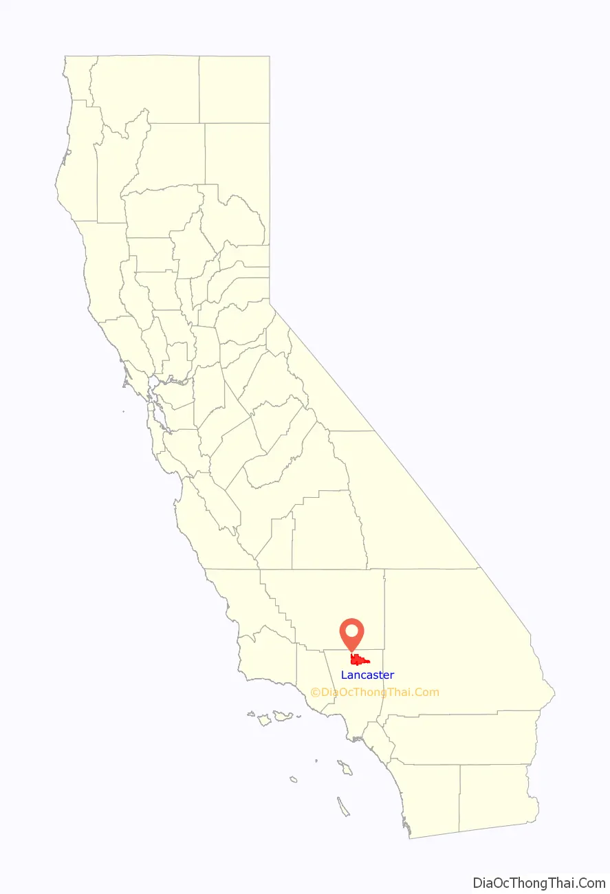
Lancaster location map. Where is Lancaster city?
History
The area where Lancaster is now located, known as the Antelope Valley, was originally home to the Paiute Indigenous tribe. The Antelope Valley’s central geography initially served as the hub of a trade route for tribes trading between the California coast, the Central Valley, the Great Basin, and the pueblos of Arizona.
After statehood, the Antelope Valley again served as a geographic shortcut but for the Stockton-Los Angeles Road and the Butterfield Overland Mail, which had two nearby stops in Mud Spring and Neenach in the 1850s. However, Lancaster’s origins as a settlement start with the Southern Pacific Railroad, which replaced the stage coach routes. The railroad built a station house, locomotive watering facility, section gang housing, and railroad track in the location of the town’s current center. In 1876 the Southern Pacific completed the line through the Antelope Valley, linking San Francisco and Los Angeles.
The origin of Lancaster’s name is unclear, attributed variously to the surname of a railroad station clerk, the moniker given by railroad officials, or the former Pennsylvania home (Lancaster, Pennsylvania) of unknown settlers. Train service brought passengers through the water-stop-turned-community, which, with the help of promotional literature, attracted new settlers. The person credited with formally developing the town is Moses Langley Wicks, who in 1884 bought property from the railroad for $2.50 per acre, mapped out a town with streets and lots, and by September was advertising 160-acre tracts of land for $6 an acre. The following year, the Lancaster News started publication, making it the first weekly newspaper in the Antelope Valley. By 1890, Lancaster was bustling and booming, and thanks to adequate rainfall, farmers planted and sold thousands of acres of wheat and barley.
The town was devastated by the decade-long drought that began in 1894, killing businesses and driving cattle north, though fortunes improved somewhat in the late-1890s following the nearby discoveries of gold and borax. The Tropico Gold Mine in Rosamond was briefly the largest goldmine in Southern California before its 1956 closure. The Pacific Coast Borax Company mine would later become the world’s largest borax mine, producing nearly half of the world’s supply of borates. The construction of the Los Angeles Aqueduct, starting in 1908, brought growth to the local economy by housing the aqueduct workers and introducing a steady stream of water. The 1912 completion of Antelope Valley High School allowed students from the growing region to study locally instead of moving to distant cities, hosting the state’s first high school dormitory system.
The community began a steady growth spurt in the 1930s, starting with construction of Muroc Air Force Base (renamed to Edwards AFB), site of frequent flight tests, including the “breaking” of the sound barrier by Chuck Yeager in a Bell X-1A in 1947. From the 1980s through the end of the program, Edwards AFB hosted a limited number of landings of the Space Shuttle. The development of Air Force Plant 42 in 1958, augmented in the 1960s by construction of Lockheed Aircraft’s Plant 10, created tens of thousands of jobs. High-wage employment hit its peak in the 1970s during the Lockheed L-1011 commercial wide body jetliner project, for which all assembly and some engineering and parts production were performed. 250 L-1011 aircraft were assembled and flown from this plant and airfield. Lancaster was an unincorporated community in Los Angeles County until 1977, when it was incorporated as a city, with Arnold Rodio serving as its first mayor.
Lancaster State Prison opened in 1993 and before that Los Angeles County hosted no prisons but accounted for forty percent of California’s state-prison inmates. “Most of Lancaster’s civic leaders and residents” opposed the building of the prison, and four inmates escaped from LAC in its first year of operation. Nevertheless, by 2000 a proposal to increase the proportion of maximum-security inmates received little criticism.
In 2005, Hyundai Motor Co. announced the grand opening of a 4,300-acre, $60 million “Proving Ground,” a state-of-the-art testing facility for cars and sports utility vehicles in nearby California City.
Lancaster is now home to major defense contractors such as Boeing, Northrop Grumman, Lockheed Martin, BAE Systems, and government agencies, such as the NASA Armstrong Flight Research Center, which are all active in design, testing, and manufacturing of a variety of military and commercial equipment. Notable projects assembled and/or designed there include the Space Shuttle orbiters, B-1 Lancer bomber, B-2 Spirit bomber, F-117 Nighthawk fighter, F-35 Joint Strike Fighter, and the Lockheed L-1011 TriStar, a wide body passenger jet aircraft. The region is also proximate to the Mojave Air & Space Port, which is famous as the base of operations for Virgin Galactic and Scaled Composites, the company that designed SpaceShipOne and won the X-Prize.
In 2010, the city opened The BLVD, a one-mile revitalized stretch of Lancaster Boulevard between 10th Street West and Sierra Highway, with additional construction on Elm Avenue and Fig Avenue continuing for the next few months.
City leaders set the goal of becoming the nation’s first Net-Zero municipality, wherein the city would produce more clean energy than it consumes. Much of the city’s infrastructure including City Hall, local schools, and the minor league baseball stadium are solar-powered. In March 2013, Lancaster became the first city in the USA to require solar panels on all new homes in an effort to make the community more carbon neutral. The rule took effect in January 2014.
War Eagle Field / Mira Loma
War Eagle Field is a former airfield located in the Mojave Desert, about 5 mi (8.0 km) west of central Lancaster.
Polaris Flight Academy, which opened on the field’s grounds on July 15, 1941, trained cadets for the Royal Air Force and the Royal Canadian Air Force. (The school also used two auxiliary fields, Liberty Field and Victory Field.) The airfield had two hard-surfaced bituminous runways, one of 3,100′ aligned NE/SW (05/23) the other of 2,950′ aligned E/W (09/27).
After the Japanese attack of Pearl Harbor, the flight school began training cadets for the United States Army Air Force on 28 July 1942, being operated by the Polaris Flight Academy as a contract basic flying school (phase 1). The primary trainer in use was the BT-13 Valiant.
In 1944, the flight school changed its name to Mira Loma Flight Academy. The airfield inactivated on 1 October 1945 and was declared surplus in 1946. Responsibility for it was given to the War Assets Administration. The land was then bought by Los Angeles County. The airfield was converted to the Mira Loma Detention Center. In 2012, Los Angeles County closed the detention center. Los Angeles County is currently collaborating with the City of Lancaster, the faith-based community, and the non-profit community to convert the facility into a winter shelter.
Many wartime buildings, including two still intact hangars, are still in use. On the roof of one of the hangars, the name War Eagle is still faintly perceptible. Flight operations continue at the airfield with a helicopter pad, used by the Los Angeles Sheriff’s Department.
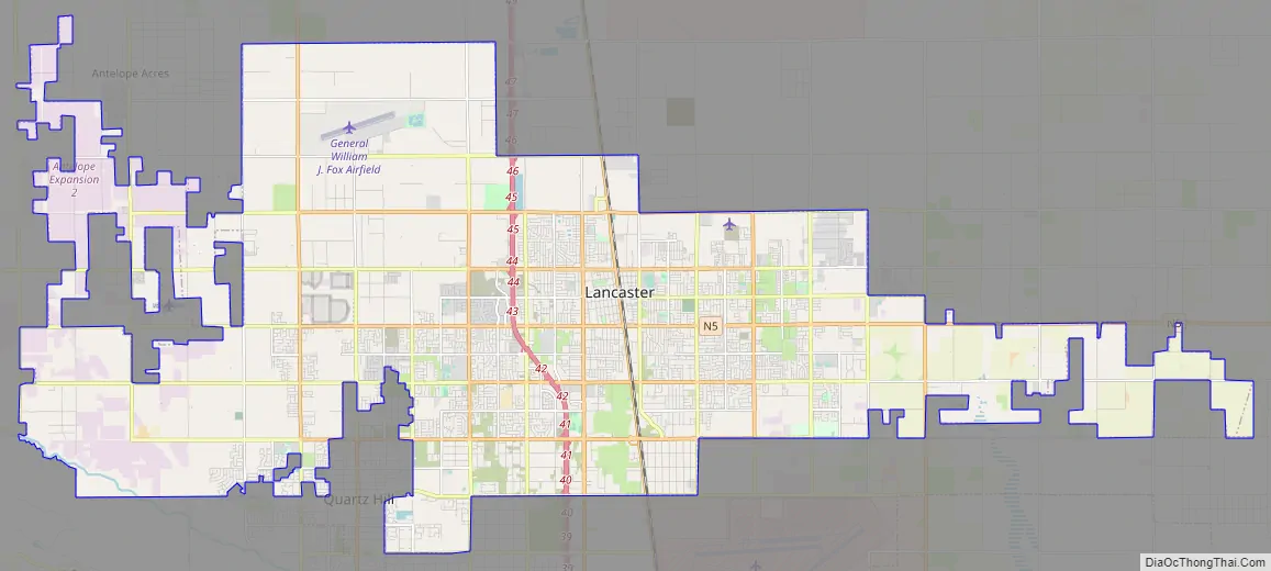
Lancaster Road Map
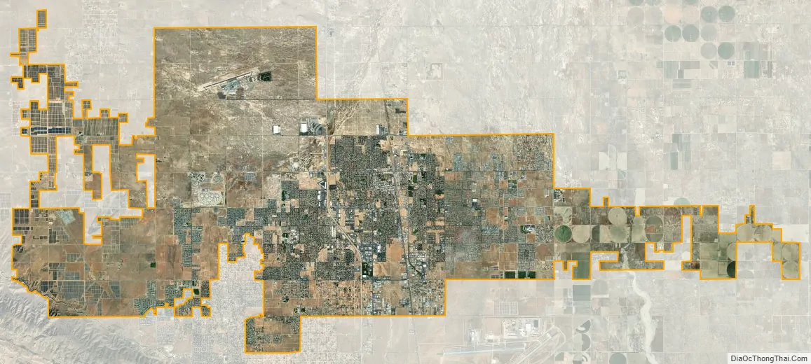
Lancaster city Satellite Map
Geography
According to the United States Census Bureau, the city has a total area of 94.5 square miles (245 km), of which 94.3 square miles (244 km) is land and 0.3 square miles (0.78 km) (0.29%) is water. Lancaster’s elevation is 2,350 feet (720 m) above sea level on a high, flat valley surrounded by pristine mountain ranges. Because the elevation is in the range of 2,000 to 3,000 feet (600–900 m) above sea level, the area, like the other parts of the Mojave Desert region, is alternatively referred to as the High Desert. Some cities and communities within the trading area of Lancaster include Palmdale, Rosamond, Lake Los Angeles, Quartz Hill, Ridgecrest, and Santa Clarita. Residents of these desert cities and unincorporated communities share Sierra Highway, Angeles Forest Highway, Angeles Crest Highway (State Route 2), and the Antelope Valley Freeway (State Route 14) for commutes to the San Fernando Valley and Los Angeles Basin.
The unincorporated community of Del Sur is an enclave of the city of Lancaster.
Climate
Lancaster has a semi-arid climate, bordering on an arid climate. The area within Lancaster is covered by shrublands (80%), forests (8%), grasslands (7%), lakes and rivers (2%), and croplands (2%). Lancaster and its immediate surroundings are part of USDA Plant Hardiness Zone 8b. Winters are cool to mild, with daily normal minimum temperatures at or just below freezing from late November until late January; summers are hot and nearly rainless. On average, annually there are 68 mornings with a minimum at or below freezing, and 35.7 afternoons with a maximum at or above 100 °F (37.8 °C). With a normal annual precipitation of 6.81 inches (173 millimeters), clear days are the norm even in winter, when surrounding mountain ranges are blanketed with snow. Thunderstorms are infrequent but do occur in July through September. There a mild frost throughout March, and temperatures begin to climb in April. Spring wildflowers are abundant, including Lupines, the California Poppy, Fiddlenecks, purple owl’s clover, California Goldfields, Creamcups, and Coreopsis. Summer nights are cool and the Pacific tree frog or barn owl can be heard. Average annual snowfall is around 2 inches (5.1 cm).
The record high temperature in Lancaster was 115 °F (46.1 °C) on June 30, 2013. The record low temperature was 2 °F (−16.7 °C) on December 24, 1984. The wettest “rain year” was from July 1992 to June 1993 with 19.57 inches (497.1 mm) and the driest from July 2012 to June 2013 with 1.26 inches (32.0 mm). The most precipitation in one month was 7.46 inches (189.5 mm) in January 1993. The most precipitation in one twenty-four-hour period was 2.93 inches (74.4 mm) on March 1, 1983. In December 1979, 23.9 inches (0.61 m) of snow fell in Lancaster.
See also
Map of California State and its subdivision:- Alameda
- Alpine
- Amador
- Butte
- Calaveras
- Colusa
- Contra Costa
- Del Norte
- El Dorado
- Fresno
- Glenn
- Humboldt
- Imperial
- Inyo
- Kern
- Kings
- Lake
- Lassen
- Los Angeles
- Madera
- Marin
- Mariposa
- Mendocino
- Merced
- Modoc
- Mono
- Monterey
- Napa
- Nevada
- Orange
- Placer
- Plumas
- Riverside
- Sacramento
- San Benito
- San Bernardino
- San Diego
- San Francisco
- San Joaquin
- San Luis Obispo
- San Mateo
- Santa Barbara
- Santa Clara
- Santa Cruz
- Shasta
- Sierra
- Siskiyou
- Solano
- Sonoma
- Stanislaus
- Sutter
- Tehama
- Trinity
- Tulare
- Tuolumne
- Ventura
- Yolo
- Yuba
- Alabama
- Alaska
- Arizona
- Arkansas
- California
- Colorado
- Connecticut
- Delaware
- District of Columbia
- Florida
- Georgia
- Hawaii
- Idaho
- Illinois
- Indiana
- Iowa
- Kansas
- Kentucky
- Louisiana
- Maine
- Maryland
- Massachusetts
- Michigan
- Minnesota
- Mississippi
- Missouri
- Montana
- Nebraska
- Nevada
- New Hampshire
- New Jersey
- New Mexico
- New York
- North Carolina
- North Dakota
- Ohio
- Oklahoma
- Oregon
- Pennsylvania
- Rhode Island
- South Carolina
- South Dakota
- Tennessee
- Texas
- Utah
- Vermont
- Virginia
- Washington
- West Virginia
- Wisconsin
- Wyoming


