Los Altos (/lɔːs ˈæltoʊs/ (listen); Spanish for “The Heights”) is a city in Santa Clara County, California, in the San Francisco Bay Area. The population was 31,625 according to the 2020 census.
Most of the city’s growth occurred between 1950 and 1980. Originally an agricultural town with many summer cottages and apricot orchards, Los Altos is now an affluent bedroom community on the western edge of Silicon Valley, serving as a major source of commuters to other parts of Silicon Valley. Los Altos strictly limits commercial zones to the downtown area and small shopping and office parks lining Foothill Expressway and El Camino Real.
| Name: | Los Altos city |
|---|---|
| LSAD Code: | 25 |
| LSAD Description: | city (suffix) |
| State: | California |
| County: | Santa Clara County |
| Incorporated: | December 1, 1952 |
| Elevation: | 157 ft (48 m) |
| Total Area: | 6.54 sq mi (16.94 km²) |
| Land Area: | 6.54 sq mi (16.94 km²) |
| Water Area: | 0.00 sq mi (0.00 km²) |
| Total Population: | 31,625 |
| Population Density: | 4,800/sq mi (1,900/km²) |
| ZIP code: | 94022–94024 |
| Area code: | 650 |
| FIPS code: | 0643280 |
| Website: | www.losaltosca.gov |
Online Interactive Map
Click on ![]() to view map in "full screen" mode.
to view map in "full screen" mode.
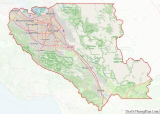
Los Altos location map. Where is Los Altos city?


History
The area was originally called “Banks and Braes”. Paul Shoup, an executive of the Southern Pacific Railroad, and his colleagues formed the Altos Land Company in 1906 and started the development of Los Altos. The company acquired 140 acres (57 ha) of land from Sarah Winchester. Shoup wanted to link Palo Alto and Los Gatos by making Los Altos a commuter town. It continued a train-a-day operation to and from San Francisco.
In 1908, Southern Pacific Railroad began running steam train service through Los Altos (April 19, 1908) with five trains per day. Two freight cars served as a train depot. Also, the first commercial building, Eschenbruecher’s Hardware, was built in downtown. In 1913, the craftsman-style Los Altos train station was built at 288 First Street.
By 1949, many residents were dissatisfied with the zoning policy of Santa Clara County, and there was a constant threat of annexation by neighboring Palo Alto and Mountain View, so they decided to incorporate. Los Altos became the eleventh city in Santa Clara County on December 1, 1952.
Train service ceased operation in January 1964, and the train track became Foothill Expressway. Los Altos may have a legitimate claim to having the first scientifically designed sound baffle in 1970. Santa Clara County undertook a seminal study to calculate the effects of alternate soundwall designs along Foothill Expressway. The resulting wall brought about the predicted reduction of seven to ten decibels in noise pollution levels experienced by adjacent homes.
In 1976, Apple co-founders Steve Jobs and Steve Wozniak built the first 50 Apple I computers in Jobs’s garage in Los Altos.
In 2004, landlord Judy Fusco rented her Los Altos home, later known as “Casa Facebook”, to Mark Zuckerberg; there, he and a few other associates scaled Facebook from 200,000 members to 2.5 million.
On April 15, 2021, Los Altos became home to the world’s first consumer flying car showroom.
Earthquakes
Los Altos is near the San Andreas Fault and therefore subject to earthquakes.
- 1906 San Francisco earthquake – Although Los Altos was hit extremely hard (VIII on the intensity level), the main local effort was to help rebuild nearby Santa Cruz, which was nearly destroyed.
- 1989 – On October 17, Los Altos experienced the Loma Prieta earthquake, but was spared major damage. Los Altos and its churches combined efforts to clean up hard-hit areas such as Watsonville and Santa Cruz.
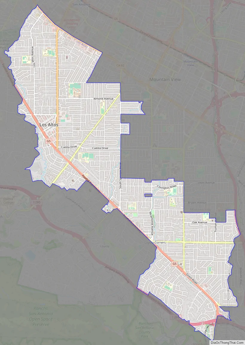
Los Altos Road Map
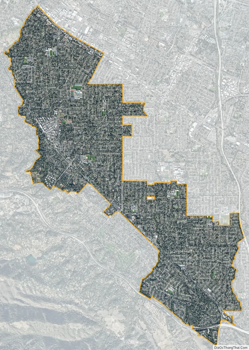
Los Altos city Satellite Map
Geography
Los Altos is bordered by Los Altos Hills to the west, Palo Alto to the west and northwest, Mountain View to the northwest and northeast, Sunnyvale to the east, and Cupertino to the southeast.
Los Altos is crossed by three creeks that flow north to San Francisco Bay, Adobe Creek on its western boundary, Stevens Creek on its eastern boundary and Permanente Creek in the middle. Hale Creek is tributary to Permanente Creek, and Permanente Creek is now largely diverted to Stevens Creek by a diversion channel. All three creeks originate on the flanks of Black Mountain.
See also
Map of California State and its subdivision:- Alameda
- Alpine
- Amador
- Butte
- Calaveras
- Colusa
- Contra Costa
- Del Norte
- El Dorado
- Fresno
- Glenn
- Humboldt
- Imperial
- Inyo
- Kern
- Kings
- Lake
- Lassen
- Los Angeles
- Madera
- Marin
- Mariposa
- Mendocino
- Merced
- Modoc
- Mono
- Monterey
- Napa
- Nevada
- Orange
- Placer
- Plumas
- Riverside
- Sacramento
- San Benito
- San Bernardino
- San Diego
- San Francisco
- San Joaquin
- San Luis Obispo
- San Mateo
- Santa Barbara
- Santa Clara
- Santa Cruz
- Shasta
- Sierra
- Siskiyou
- Solano
- Sonoma
- Stanislaus
- Sutter
- Tehama
- Trinity
- Tulare
- Tuolumne
- Ventura
- Yolo
- Yuba
- Alabama
- Alaska
- Arizona
- Arkansas
- California
- Colorado
- Connecticut
- Delaware
- District of Columbia
- Florida
- Georgia
- Hawaii
- Idaho
- Illinois
- Indiana
- Iowa
- Kansas
- Kentucky
- Louisiana
- Maine
- Maryland
- Massachusetts
- Michigan
- Minnesota
- Mississippi
- Missouri
- Montana
- Nebraska
- Nevada
- New Hampshire
- New Jersey
- New Mexico
- New York
- North Carolina
- North Dakota
- Ohio
- Oklahoma
- Oregon
- Pennsylvania
- Rhode Island
- South Carolina
- South Dakota
- Tennessee
- Texas
- Utah
- Vermont
- Virginia
- Washington
- West Virginia
- Wisconsin
- Wyoming