Gilroy is a city in Northern California’s Santa Clara County, south of Morgan Hill and north of San Benito County. Gilroy is the southernmost city in the San Francisco Bay Area, with a population of 59,520 as of the 2020 Census.
Gilroy’s origins lie in the village of San Ysidro that grew in the early 19th century out of Rancho San Ysidro, granted to Californio ranchero Ygnacio Ortega in 1809. Following Ygnacio’s death in 1833, his daughter Clara Ortega de Gilroy and son-in-law John Gilroy inherited the largest portion of the rancho and began developing the settlement. When the town was incorporated in 1868, it was renamed in honor of John Gilroy, a Scotsman who had emigrated to California in 1814, naturalized as a Mexican citizen, adopted the Spanish language, and converted to Catholicism, taking the name of Juan Bautista Gilroy.
Gilroy is known for its garlic crop and the annual Gilroy Garlic Festival, featuring various garlicky foods such as garlic ice cream, leading to the city’s nickname, the Garlic Capital of the World. It is also known for boutique wine production, as part of the Santa Clara Valley AVA, mostly consisting of family vineyards around the base of the Santa Cruz Mountains to the west.
| Name: | Gilroy city |
|---|---|
| LSAD Code: | 25 |
| LSAD Description: | city (suffix) |
| State: | California |
| County: | Santa Clara County |
| Incorporated: | March 12, 1870 |
| Elevation: | 200 ft (61 m) |
| Land Area: | 16.51 sq mi (42.75 km²) |
| Water Area: | 0.01 sq mi (0.03 km²) 0.06% |
| Population Density: | 3,576.18/sq mi (1,380.75/km²) |
| ZIP code: | 95020, 95021 |
| Area code: | 408/669 |
| FIPS code: | 0629504 |
| Website: | www.ci.gilroy.ca.us |
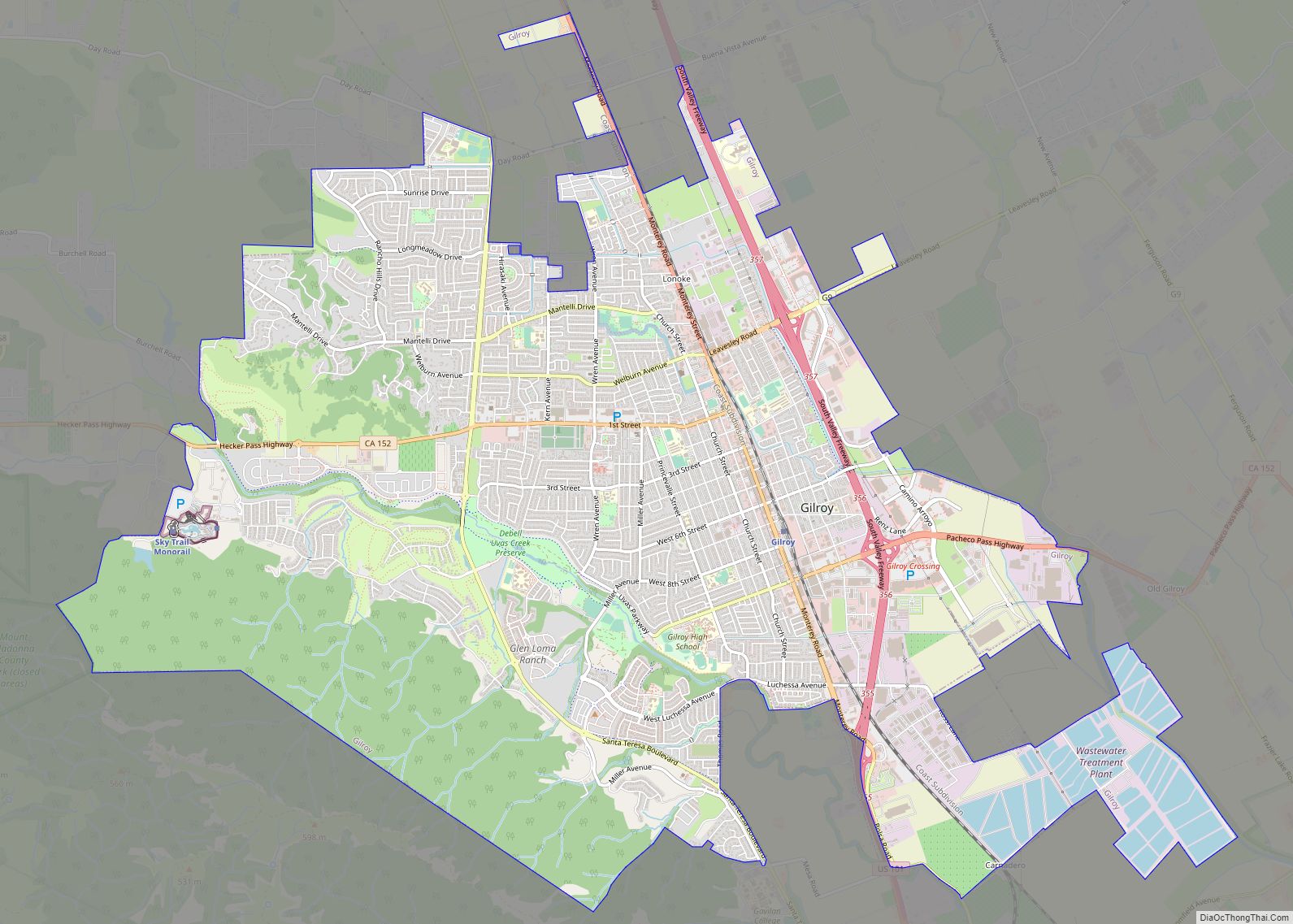
Online Interactive Map
Click on ![]() to view map in "full screen" mode.
to view map in "full screen" mode.
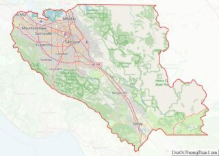
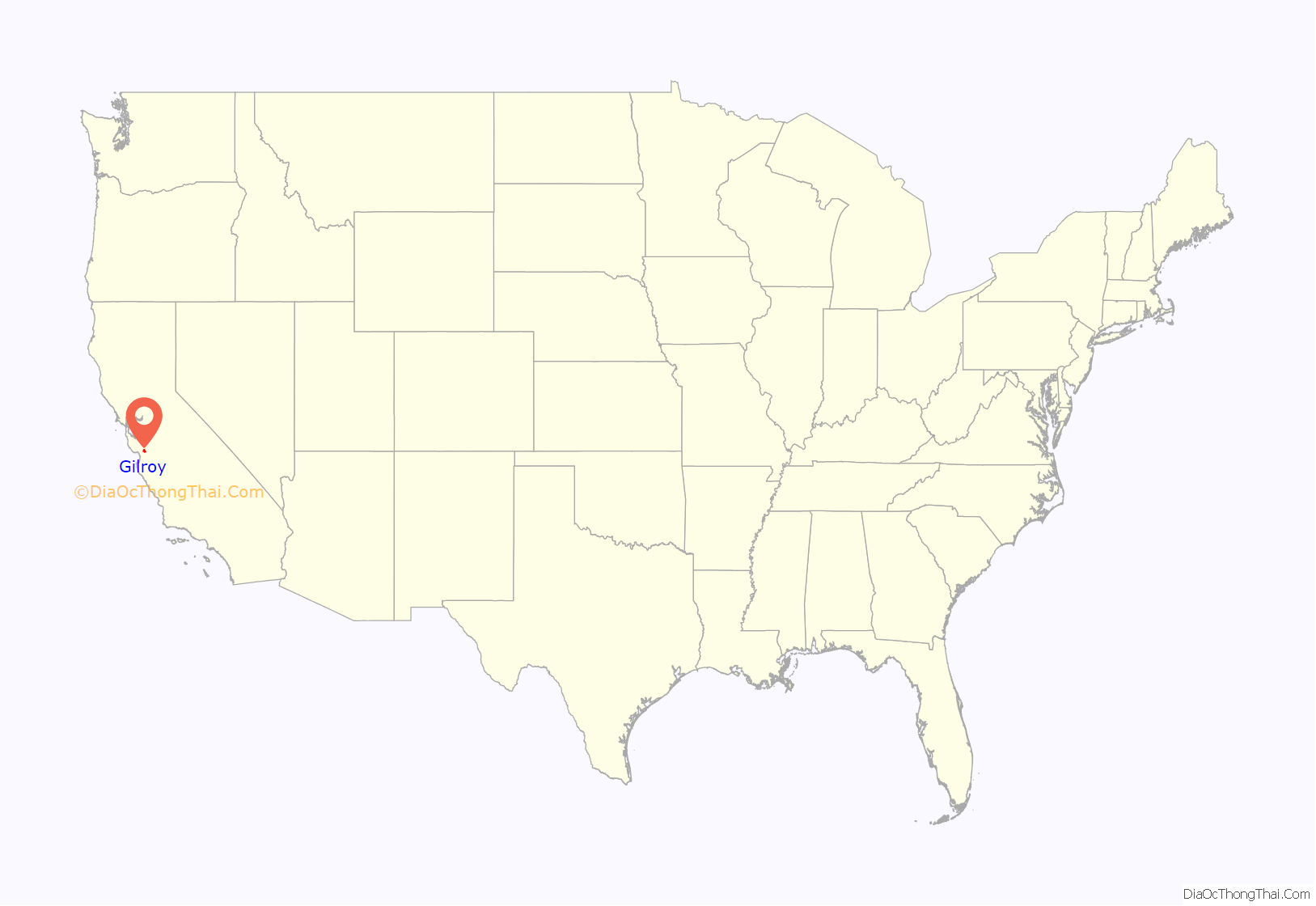
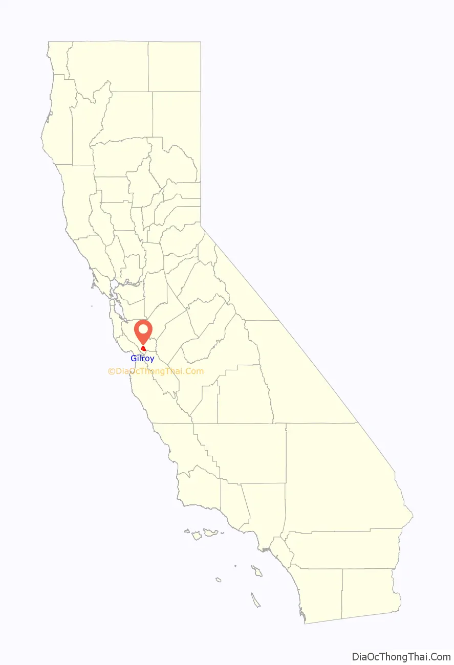
Gilroy location map. Where is Gilroy city?
History
Spanish era
Spanish explorers led by Juan Bautista de Anza first passed through the Santa Clara Valley area in 1776, and in 1797 Mission San Juan Bautista was established near the Pajaro River. In 1809, Ygnacio Ortega was granted the 13,066-acre (5,288 ha) Spanish land concession Rancho San Ysidro. The village of San Ysidro grew nearby, at the foot of Pacheco Pass which linked the El Camino Real and the Santa Clara Valley with the San Joaquin Valley. California’s main exports at this time were hides and tallow, of which thousands of barrels were produced and shipped to the rest of New Spain. Trade and diplomatic intercourse with foreigners was strictly forbidden by the royal government but was quietly carried on by Californians desperate for luxury goods.
Mexican era
During the War of 1812, the armed merchantman Isaac Todd was sent by the North West Company to seize Fort Astoria, an American trading post at the mouth of the Columbia River. The ship, with a Royal Navy escort, departed from Portsmouth, England, made its way around Cape Horn and proceeded up the Pacific coast of the Americas, stopping at Spanish ports for supplies along the way. In January 1814, having fallen behind its escort, the Isaac Todd arrived at Monterey, California, the Spanish colonial capital of Alta California. During the visit, ordinary seaman John Gilroy (a Scotsman who had changed his name from John Cameron when he went to sea to avoid recognition) either (depending on the historical source) jumped ship or was left ashore to recover from scurvy.
John Gilroy (1794–1869), also known as Juan Bautista Gilroy, spent the next few years moving around among the missions, pueblos and ranchos, plying his trade as a cooper (barrel maker). At first, by his own account in an 1856 letter to Thomas O. Larkin, Gilroy was one of only two English-speakers resident in Alta California. Eventually, he found his way to Rancho San Ysidro, converted to Roman Catholicism and became the first naturalized English-speaking settler in Alta California. In 1821, the same year Mexico won its independence from Spain, Gilroy married a daughter of his employer, ranchero Ygnacio Ortega. Upon Ygnacio’s death in 1833, the rancho was divided among his three children—including Gilroy’s wife Maria Clara. In 1867, under U.S. property law, the Rancho San Ysidro (Gilroy) was patented to John Gilroy.
The settlement now known as “Old Gilroy” grew up around Gilroy’s rancho complex and, after the end of the Mexican–American War in 1848, Gilroy served as alcalde of the village. It served as a stagecoach station of the Butterfield Overland Mail and other stage lines in the late 19th century.
American era
Following the U.S. Conquest of California and the discovery of gold in the Sierra Nevada in 1848, the trickle of immigrants from the eastern states and abroad became a flood. As many of the earlier Mexican and Californio landowners sold off their land, lost it to squatters, or were dispossessed through title hearings, the area around San Ysidro became known as Pleasant Valley. On March 12, 1870, it was officially incorporated by the state legislature as the town of Gilroy (John Gilroy had died in 1869). By then the town center had been relocated west of the El Camino Real (Old Gilroy is today a sparsely populated agricultural area).
Cattle ranching and timber from the nearby Santa Cruz Mountains were important to the economy for some time but, as in the rest of the valley, agriculture was the town’s greatest source of income. During the 1920s, Kiyoshi “Jimmy” Hirasaki began growing garlic commercially in the Gilroy area. Referred to as the “Garlic King”, Hirasaki continued to farm garlic into the 1950s. In 1979, the Gilroy Garlic Festival was launched. Farming remains significant, but in the 1970s the city began evolving into a bedroom community for Silicon Valley to the north.
There are a number of extant historical buildings dating from the mid-19th century. Built in 1857, the Christian Church at 160 Fifth Street is the oldest wood-framed church in continuous use in Santa Clara County. Blacksmith George Eustice’s house at 213 Fifth Street was constructed in 1869; Eustice was an American Civil War veteran who fought at Gettysburg. Samuel Moore was a long-time Gilroy postmaster, whose home was built in the 1870s at 7151 Church Street.
Nearby in the foothills of the Diablo Range to the northeast is the historic resort site Gilroy Yamato Hot Springs, first developed in the 1870s (and now closed to the public). In 1905, the Old City Hall was built in downtown Gilroy; in 1975, it was designated on the list of National Register of Historic Places.
On July 28, 2019, a mass shooting occurred at the 2019 Gilroy Garlic Festival. Three people were killed by the gunman and at least 12 others were injured. The suspect, Santino William Legan, committed suicide after being shot by police.
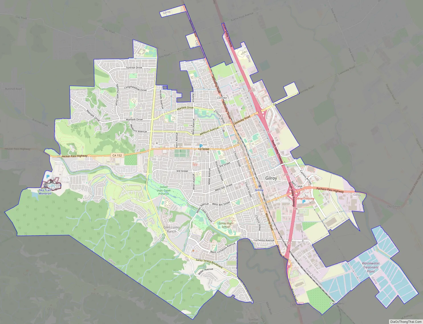
Gilroy Road Map
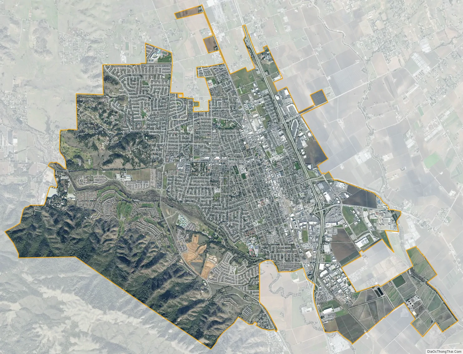
Gilroy city Satellite Map
Geography
Gilroy is approximately 16 miles (26 km) south of San Jose, California (Bailey Avenue (37.206770, -121.729150) to Monterey/Day Road (37.038210, -121.584480)) on U.S. Route 101 and 19 miles (31 km) inland from the Pacific Coast. Despite its apparent close proximity to San Jose, it is important to note that Gilroy City Hall lies at a distance of 33.3 miles (53.6 km) from San Jose City Hall. Lying in a southern extension of the Santa Clara Valley at an elevation of about 200 feet (61 m) above MSL, it is bounded by the Santa Cruz Mountains to the west and the Diablo Range to the east. According to the United States Census Bureau, the city has a total area of 16.2 square miles (42 km), of which 16.1 square miles (42 km) is land and 0.06% is water.
Primary contributors to environmental noise include U.S. Route 101, El Camino Real, Leavesley Road and other major arterials. The number of people exposed to sound levels above 60 CNEL is approximately 4,000.
Climate
Due to the moderating influence of the Pacific Ocean, Gilroy experiences a warm Mediterranean climate (Köppen Csb, bordering on Csa). Temperatures range from an average midsummer maximum of 90.1 °F (32.3 °C) to an average midwinter low of 33.6 °F (0.9 °C). Average annual precipitation is 18.9 inches (480 mm), and the summer months are typically dry. Snowfall is rare; occurring approximately once every 20 years, it is light and short-lived. Summer months are characterized by coastal fog which arrives from the ocean around 10 p.m. and dissipates the next morning by 10 a.m. During summer afternoons, the maritime influence lowers and, as a result, Gilroy is much more prone to heat waves than nearby geographical areas to its north and west. Winter months have many sunny and partly cloudy days, with frequent breaks between rainstorms. The local terrain is not conducive to tornadoes, severe windstorms, or thunderstorms. The local climate supports chaparral and grassland biomes, with stands of live oak at higher elevations.
Average temperatures in December, the coldest month, are a maximum of 60.4 °F (15.8 °C) and a minimum of 37.0 °F (2.8 °C). Average temperatures in August, the hottest month, are a maximum of 87.2 °F (30.7 °C) and a minimum of 54.4 °F (12.4 °C). There are an average of 7.7 days with highs of 100 °F (38 °C) or higher and an average of 16.1 days with lows of 32 °F (0 °C) or lower. The record high temperature of 115 °F (46 °C) occurred on July 15, 1972. The record low temperature of 17 °F (−8 °C) occurred on December 22–24, 1990.
There are an average of 55.0 days with measurable precipitation. The wettest year was 1983 with 37.76 inches (959 mm) and the driest year was 1977 and 2007, both with 11.17 inches (284 mm). The most rainfall in one month was 14.64 inches (372 mm) in January 1914.
See also
Map of California State and its subdivision:- Alameda
- Alpine
- Amador
- Butte
- Calaveras
- Colusa
- Contra Costa
- Del Norte
- El Dorado
- Fresno
- Glenn
- Humboldt
- Imperial
- Inyo
- Kern
- Kings
- Lake
- Lassen
- Los Angeles
- Madera
- Marin
- Mariposa
- Mendocino
- Merced
- Modoc
- Mono
- Monterey
- Napa
- Nevada
- Orange
- Placer
- Plumas
- Riverside
- Sacramento
- San Benito
- San Bernardino
- San Diego
- San Francisco
- San Joaquin
- San Luis Obispo
- San Mateo
- Santa Barbara
- Santa Clara
- Santa Cruz
- Shasta
- Sierra
- Siskiyou
- Solano
- Sonoma
- Stanislaus
- Sutter
- Tehama
- Trinity
- Tulare
- Tuolumne
- Ventura
- Yolo
- Yuba
- Alabama
- Alaska
- Arizona
- Arkansas
- California
- Colorado
- Connecticut
- Delaware
- District of Columbia
- Florida
- Georgia
- Hawaii
- Idaho
- Illinois
- Indiana
- Iowa
- Kansas
- Kentucky
- Louisiana
- Maine
- Maryland
- Massachusetts
- Michigan
- Minnesota
- Mississippi
- Missouri
- Montana
- Nebraska
- Nevada
- New Hampshire
- New Jersey
- New Mexico
- New York
- North Carolina
- North Dakota
- Ohio
- Oklahoma
- Oregon
- Pennsylvania
- Rhode Island
- South Carolina
- South Dakota
- Tennessee
- Texas
- Utah
- Vermont
- Virginia
- Washington
- West Virginia
- Wisconsin
- Wyoming