Tulare (/tʊˈlɛəri/ (listen) tuu-LAIR-ee) is a city in Tulare County, California. The population was 68,875 at the 2020 census. It is located in the heart of the San Joaquin Valley, eight miles south of Visalia and sixty miles north of Bakersfield. The city is named for the Tulare Lake, once the largest freshwater lake west of the Great Lakes.
| Name: | Tulare city |
|---|---|
| LSAD Code: | 25 |
| LSAD Description: | city (suffix) |
| State: | California |
| County: | Tulare County |
| Incorporated: | April 5, 1888 |
| Elevation: | 289 ft (88 m) |
| Total Area: | 20.46 sq mi (53.00 km²) |
| Land Area: | 20.39 sq mi (52.80 km²) |
| Water Area: | 0.08 sq mi (0.20 km²) 0.41% |
| Total Population: | 68,875 |
| Population Density: | 3,212.95/sq mi (1,240.50/km²) |
| ZIP code: | 93274, 93275 |
| Area code: | 559 |
| FIPS code: | 0680644 |
| Website: | www.tulare.ca.gov |
Online Interactive Map
Click on ![]() to view map in "full screen" mode.
to view map in "full screen" mode.
Tulare location map. Where is Tulare city?


History
The Yokuts people built reed boats and fished in what was later to be called Tulare Lake in their homeland for centuries, until the invasion and settlement by the Spanish and American pioneers. When California became a state in 1850, Tulare did not yet exist as a town. Tulare was founded in 1872, by the Southern Pacific Railroad. The town was named for Lake Tulare. The lake had been named for the tule rush plant (Schoenoplectus acutus) (pictured left), a species of bulrush that predominantly lined the marshes and sloughs of its shore.
Transportation was the first impetus behind the establishment of the town. Tulare flourished as the headquarters of the railroad in the area. The town suffered through many difficult challenges, but despite burning down and being rebuilt three times in its first fourteen years of existence, it was eventually incorporated in 1888.
In 1891, the railroad moved its headquarters to Bakersfield, decimating the community. Although the railroad was gone, the community of Tulare struggled to become an agricultural center for California, which it is today. Due to the inadequate 10 inches (250 mm) of rainfall per year, water resources had to be found. In order to bring water to Tulare, citizens established the Tulare Irrigation District and issued $500,000 in bonds to build an extensive canal system carrying water from the Sierra Nevada. In 1903, when the bonds were paid off early, they celebrated by having a bond-burning celebration. Once the water system was established, Tulare burgeoned, becoming a center for farming and agriculture because of its central location.
In 1912, Hulett C. Merritt founded Tagus Ranch, which at 7,000 acres (2,800 ha) was the largest fruit ranch in the world. Until its close, Tagus Ranch produce was known the world over, and was served in the finest restaurants throughout America. At the end of World War II, a portion of Tagus Ranch served as a German POW camp.
The cotton strike of the California agricultural strikes of 1933 was planned in Tulare by a group of seventy-eight men and women. As recorded by Chicano historian Rodolfo Acuña, “they concluded that it took the average picker 10 hours to harvest 300 pounds. Planters offered 40 cents a hundredweight – that was not enough to buy enough food and gas to get to the next job.”
In 1940, famed aerobatic stunt pilot J.G. “Tex” Rankin secured a U.S. War Department contract to open and operate a civilian flying school to train United States Army Air Corps flight cadets. Rankin opened the Rankin Aeronautical Academy in Tulare in February 1941, where it operated throughout the duration of World War II. During its heyday Rankin Field, as it was otherwise known, trained 10,000 pilots in primary flight training, including twelve future Army Air Corps Aces and two Medal of Honor recipients.
During World War II, in response to West Coast wartime hysteria, the U.S. Army temporarily assumed control of the Tulare County Fairgrounds, converting it to the Tulare Assembly Center, a temporary detention center for Japanese Americans. The Assembly Center was administered by the Wartime Civil Control Administration, under the Western Defense Command and the U.S. 4th Army. The first internee was inducted on April 27, 1942, and the last internee departed on September 4, 1942. The top population numbered 4,978 residents, many of whom were citizens born in the United States. In the latter part of 1942, internees began being moved to the ten more permanent “War Relocation Camps”. The majority of internees from the Tulare Assembly Center were sent to the Gila River War Relocation Center in Arizona. These temporary sites were largely located on fairgrounds or race tracks in completely public and visible locations.
Tulare was the site of the National Championships for the Decathlon in Track and Field in 1949, 1950, 1952, and 1962, as well as the Olympic Trials for the Decathlon in 1952.
Tulare Road Map

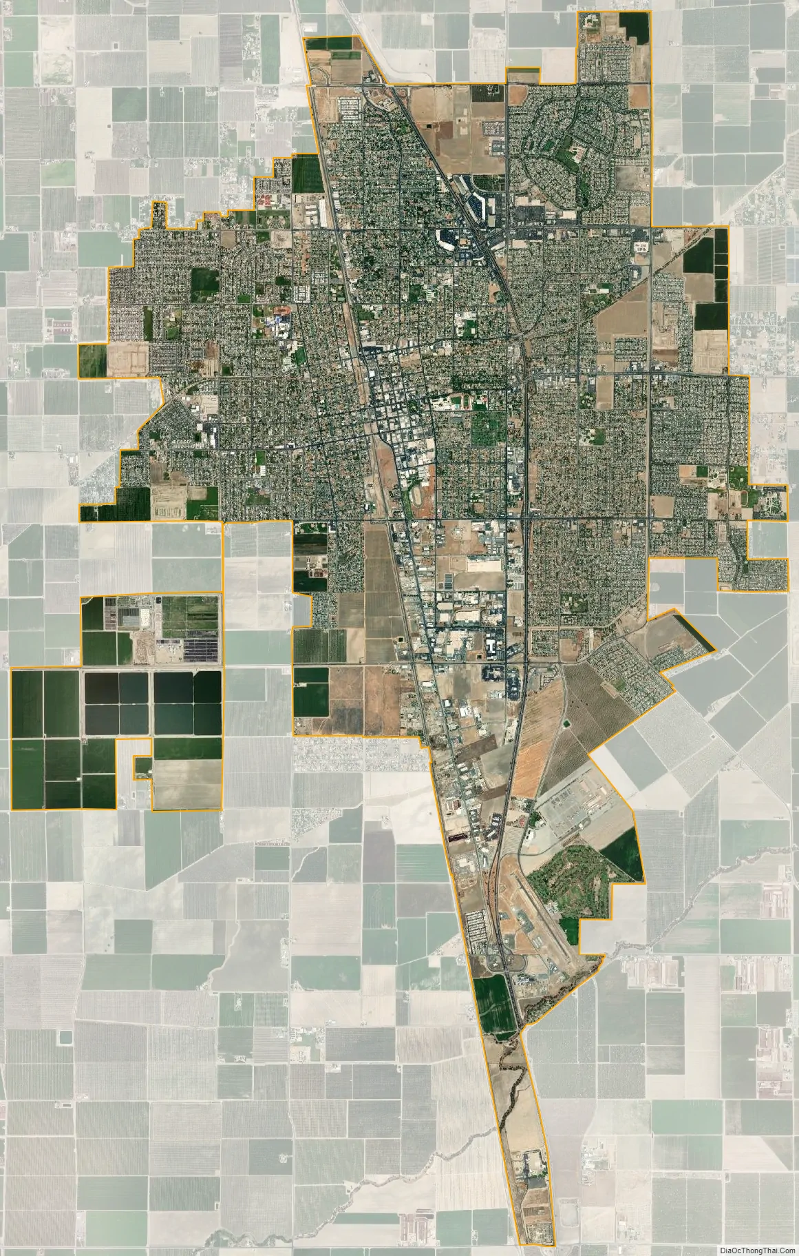
Tulare city Satellite Map
Geography
Tulare is located at 36°12′24″N 119°20′33″W / 36.20667°N 119.34250°W / 36.20667; -119.34250 (36.206601, −119.342404). Located directly between Fresno and Bakersfield, Tulare is in the heart of the Central Valley. Although the foothills of the Sierra Nevada are only about 20 miles east of town, they are seldom visible due to the chronically poor air quality and very high levels of airborne particulate matter, soot, and other pollution.
According to the United States Census Bureau, the city has a total area of 21.0 square miles (54 km), of which 20.9 square miles (54 km) is land and 0.1 square miles (0.26 km) (0.41%) is water.
Climate
The climate of this agricultural community is varied, with cool and damp winters with a mean temperature of 45 degrees, but very hot dry summers, with a mean temperatures of 95 to 110 degrees. The mean average rainfall was 10 inches prior to the drought that began in 2012 and remains ongoing as of September 2018. Tulare consistently suffers from year round air pollution and air quality that is among the worst in the United States because of both geographic conditions (hemmed in valley, weak winds) and the prevalence of diesel fuel exhaust from farming and truck traffic on Highway 99. Farming also exacerbates this because it kicks up tremendous amounts of dust, especially in the late summer and autumn months.
See also
Map of California State and its subdivision:- Alameda
- Alpine
- Amador
- Butte
- Calaveras
- Colusa
- Contra Costa
- Del Norte
- El Dorado
- Fresno
- Glenn
- Humboldt
- Imperial
- Inyo
- Kern
- Kings
- Lake
- Lassen
- Los Angeles
- Madera
- Marin
- Mariposa
- Mendocino
- Merced
- Modoc
- Mono
- Monterey
- Napa
- Nevada
- Orange
- Placer
- Plumas
- Riverside
- Sacramento
- San Benito
- San Bernardino
- San Diego
- San Francisco
- San Joaquin
- San Luis Obispo
- San Mateo
- Santa Barbara
- Santa Clara
- Santa Cruz
- Shasta
- Sierra
- Siskiyou
- Solano
- Sonoma
- Stanislaus
- Sutter
- Tehama
- Trinity
- Tulare
- Tuolumne
- Ventura
- Yolo
- Yuba
- Alabama
- Alaska
- Arizona
- Arkansas
- California
- Colorado
- Connecticut
- Delaware
- District of Columbia
- Florida
- Georgia
- Hawaii
- Idaho
- Illinois
- Indiana
- Iowa
- Kansas
- Kentucky
- Louisiana
- Maine
- Maryland
- Massachusetts
- Michigan
- Minnesota
- Mississippi
- Missouri
- Montana
- Nebraska
- Nevada
- New Hampshire
- New Jersey
- New Mexico
- New York
- North Carolina
- North Dakota
- Ohio
- Oklahoma
- Oregon
- Pennsylvania
- Rhode Island
- South Carolina
- South Dakota
- Tennessee
- Texas
- Utah
- Vermont
- Virginia
- Washington
- West Virginia
- Wisconsin
- Wyoming


