Poughkeepsie (/pəˈkɪpsi/ pə-KIP-see), officially the City of Poughkeepsie, separate from the Town of Poughkeepsie around it) is a city in the U.S. state of New York. It is the county seat of Dutchess County, with a 2020 census population of 31,577. Poughkeepsie is in the Hudson River Valley region, midway between the core of the New York metropolitan area and the state capital of Albany. It is a principal city of the Poughkeepsie–Newburgh–Middletown metropolitan area which belongs to the New York combined statistical area. It is served by the nearby Hudson Valley Regional Airport and Stewart International Airport in Orange County, New York.
Poughkeepsie has been called “The Queen City of the Hudson”. It was settled in the 17th century by the Dutch and became New York State’s second capital shortly after the American Revolution. It was chartered as a city in 1854. Major bridges in the city include the Walkway over the Hudson, a former railroad bridge called the Poughkeepsie Bridge which reopened as a public walkway on October 3, 2009; and the Mid-Hudson Bridge, a major thoroughfare built in 1930 that carries U.S. Route 44 over the Hudson. The city of Poughkeepsie lies in New York’s 18th congressional district.
The City of Poughkeepsie and neighboring Town of Poughkeepsie are generally viewed as a single place and are commonly referred to collectively as “Poughkeepsie”, with a combined population of 74,751 in 2018.
Poughkeepsie is situated between the Lower Hudson and the Capital District regions, and the city’s economy is stimulated by several major corporations, including IBM. Educational institutions include Marist College, Vassar College, Dutchess Community College and The Culinary Institute of America.
| Name: | Poughkeepsie city |
|---|---|
| LSAD Code: | 25 |
| LSAD Description: | city (suffix) |
| State: | New York |
| County: | Dutchess County |
| Founded: | 1686; 337 years ago (1686) |
| Elevation: | 180 ft (50 m) |
| Land Area: | 5.14 sq mi (13.32 km²) |
| Water Area: | 0.57 sq mi (1.49 km²) |
| Population Density: | 6,137.41/sq mi (2,369.86/km²) |
| ZIP code: | 12601-12604 |
| Area code: | 845 |
| FIPS code: | 3659641 |
| Website: | www.cityofpoughkeepsie.com |
Online Interactive Map
Click on ![]() to view map in "full screen" mode.
to view map in "full screen" mode.
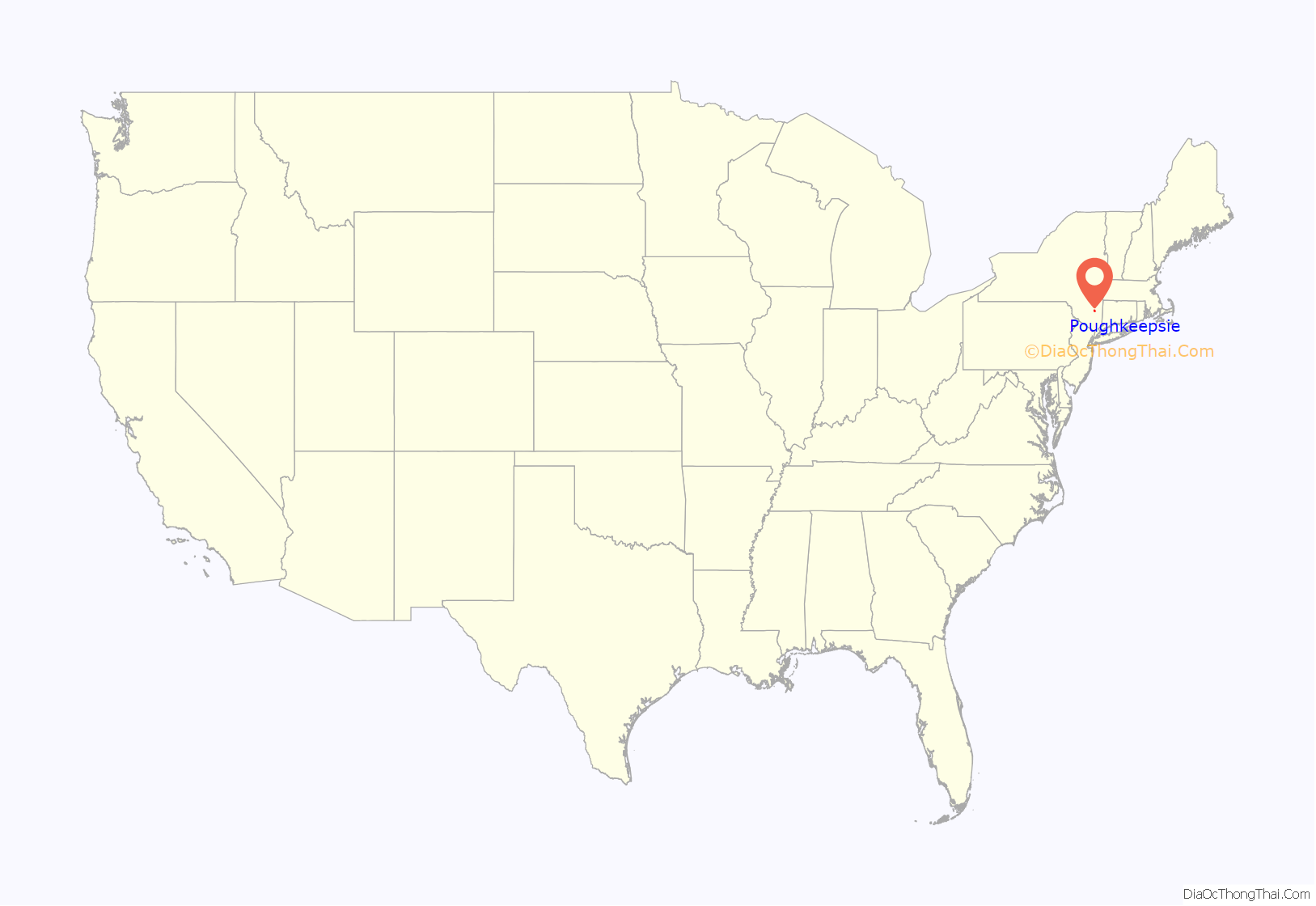
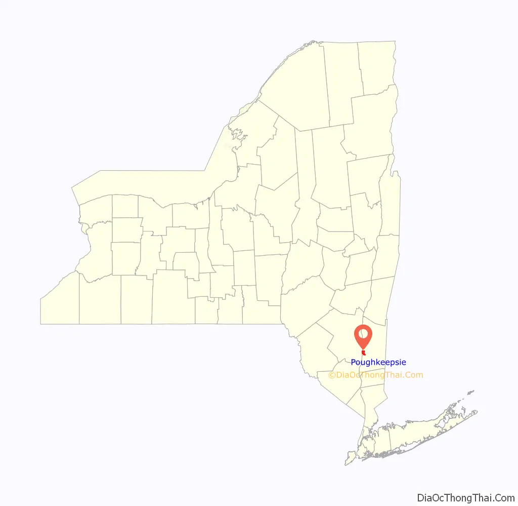
Poughkeepsie location map. Where is Poughkeepsie city?
History
English colonist Robert Sanders and Dutch colonist Myndert Harmense Van Den Bogaerdt acquired the land from a local Native American tribe in 1686, and the first settlers were the families of Barent Baltus Van Kleeck and Hendrick Jans van Oosterom. The settlement grew quickly, and the Reformed Church of Poughkeepsie was established by 1720.
The community was set off from the town of Poughkeepsie when it became an incorporated village on March 27, 1799. The city of Poughkeepsie was chartered on March 28, 1854.
The city of Poughkeepsie was spared from battle during the American Revolutionary War and became the second capital of the State of New York after Kingston was burned by the British. In 1788, the Ratification Convention for New York State included Alexander Hamilton, John Jay, and George Clinton. They assembled at the courthouse on Market Street and ratified the United States Constitution, and New York State entered the new union as the eleventh of the original Thirteen Colonies to become the United States. In 1799, a new seal was created for the city.
Poughkeepsie was a major center for whale rendering, and the industry flourished during the 19th century through shipping, millineries, paper mills, and several breweries along the Hudson River, including some owned by Matthew Vassar, founder of Vassar College. Families built palatial weekend homes nearby, such as the Astors, Rogers, and Vanderbilts, due to the area’s natural beauty and proximity to New York City. The Vanderbilt Mansion is located several miles up the Hudson from Poughkeepsie in the town of Hyde Park and is registered as a national historic site; it is considered to be a sterling example of the mansions built by American industrialists during the late 19th century. The city is home to the Bardavon 1869 Opera House, the oldest continuously operating entertainment venue in the state.
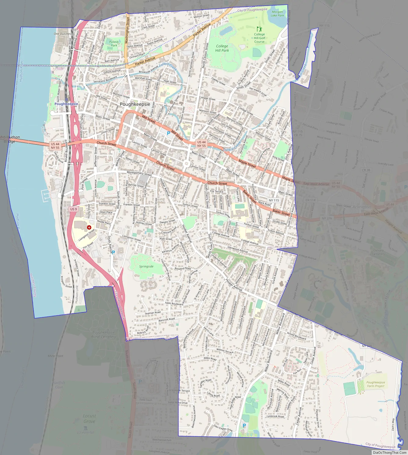
Poughkeepsie Road Map
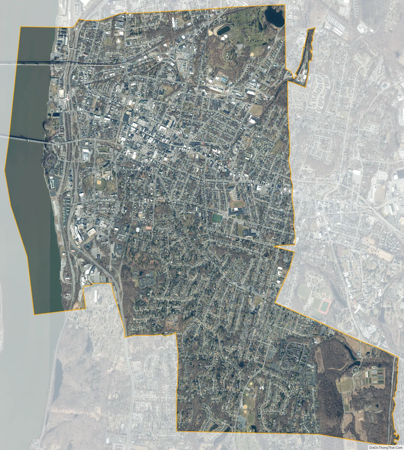
Poughkeepsie city Satellite Map
Geography
The city of Poughkeepsie is located on the western edge of Dutchess County, in Downstate New York’s Hudson River Valley Area.
It is bordered by the town of Lloyd across the Hudson River to the west and by the town of Poughkeepsie on the north, east and south. There are two crossings of the Hudson River in Poughkeepsie: the Mid-Hudson Bridge for motor vehicles and pedestrians, and the pedestrian Walkway over the Hudson.
According to the United States Census Bureau, the city has an area of 5.7 square miles (14.8 km), of which 5.1 square miles (13.3 km) is land, and 0.23 square miles (0.6 km) (comprising 10.05%) is water. Poughkeepsie lies approximately 75 miles (121 km) north of the center of the New York megacity. It is 73.5 miles (118.3 km) south of the New York state capital of Albany. The highest elevation of Poughkeepsie is 380 feet (120 m) above sea level on College Hill. Its lowest is on the Hudson River.
Poughkeepsie makes up a part of the Poughkeepsie—Newburgh—Middletown metropolitan statistical area, which is a part of the wider NY-NJ-CT combined statistical area.
Historic districts
- Academy Street Historic District
- Balding Avenue Historic District
- Dwight-Hooker Avenue Historic District
- Garfield Place Historic District
- Mill Street-North Clover Street Historic District
- Mount Carmel District
- Union Street Historic District
Climate
Poughkeepsie has a humid continental climate (Köppen Dfa) with relatively hot summers and cold winters. It receives approximately 44.12 inches (1,121 mm) of precipitation per year, much of which is delivered in the late spring and early summer. Due to its inland location, Poughkeepsie can be very cold during the winter, with temperatures dropping below 0 °F (−18 °C) a few times per year. Poughkeepsie can also be hit by powerful nor’easters, but it usually receives significantly less snow or rain from these storms compared to locations towards the south and east. Extremes range from −30 °F (−34 °C) on January 21, 1961, to 106 °F (41 °C) on July 15, 1995.
See also
Map of New York State and its subdivision:- Albany
- Allegany
- Bronx
- Broome
- Cattaraugus
- Cayuga
- Chautauqua
- Chemung
- Chenango
- Clinton
- Columbia
- Cortland
- Delaware
- Dutchess
- Erie
- Essex
- Franklin
- Fulton
- Genesee
- Greene
- Hamilton
- Herkimer
- Jefferson
- Kings
- Lake Ontario
- Lewis
- Livingston
- Madison
- Monroe
- Montgomery
- Nassau
- New York
- Niagara
- Oneida
- Onondaga
- Ontario
- Orange
- Orleans
- Oswego
- Otsego
- Putnam
- Queens
- Rensselaer
- Richmond
- Rockland
- Saint Lawrence
- Saratoga
- Schenectady
- Schoharie
- Schuyler
- Seneca
- Steuben
- Suffolk
- Sullivan
- Tioga
- Tompkins
- Ulster
- Warren
- Washington
- Wayne
- Westchester
- Wyoming
- Yates
- Alabama
- Alaska
- Arizona
- Arkansas
- California
- Colorado
- Connecticut
- Delaware
- District of Columbia
- Florida
- Georgia
- Hawaii
- Idaho
- Illinois
- Indiana
- Iowa
- Kansas
- Kentucky
- Louisiana
- Maine
- Maryland
- Massachusetts
- Michigan
- Minnesota
- Mississippi
- Missouri
- Montana
- Nebraska
- Nevada
- New Hampshire
- New Jersey
- New Mexico
- New York
- North Carolina
- North Dakota
- Ohio
- Oklahoma
- Oregon
- Pennsylvania
- Rhode Island
- South Carolina
- South Dakota
- Tennessee
- Texas
- Utah
- Vermont
- Virginia
- Washington
- West Virginia
- Wisconsin
- Wyoming


