Elba is a city in and the county seat of Coffee County, Alabama, United States. It is the official seat, although there are two county courthouses, with the other one being located in the town of Enterprise. At the time of the 2010 U.S. census, Elba’s population was 3,940. Elba is part of the Enterprise micropolitan statistical area.
| Name: | Elba city |
|---|---|
| LSAD Code: | 25 |
| LSAD Description: | city (suffix) |
| State: | Alabama |
| County: | Coffee County |
| Incorporated: | April 13, 1853 |
| Elevation: | 194 ft (59 m) |
| Total Area: | 15.42 sq mi (39.93 km²) |
| Land Area: | 15.34 sq mi (39.73 km²) |
| Water Area: | 0.08 sq mi (0.21 km²) |
| Total Population: | 3,508 |
| Population Density: | 228.71/sq mi (88.31/km²) |
| ZIP code: | 36323 |
| Area code: | 334 |
| FIPS code: | 0123296 |
| GNISfeature ID: | 0117908 |
| Website: | www.elbaal.gov |
Online Interactive Map
Click on ![]() to view map in "full screen" mode.
to view map in "full screen" mode.
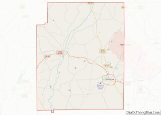
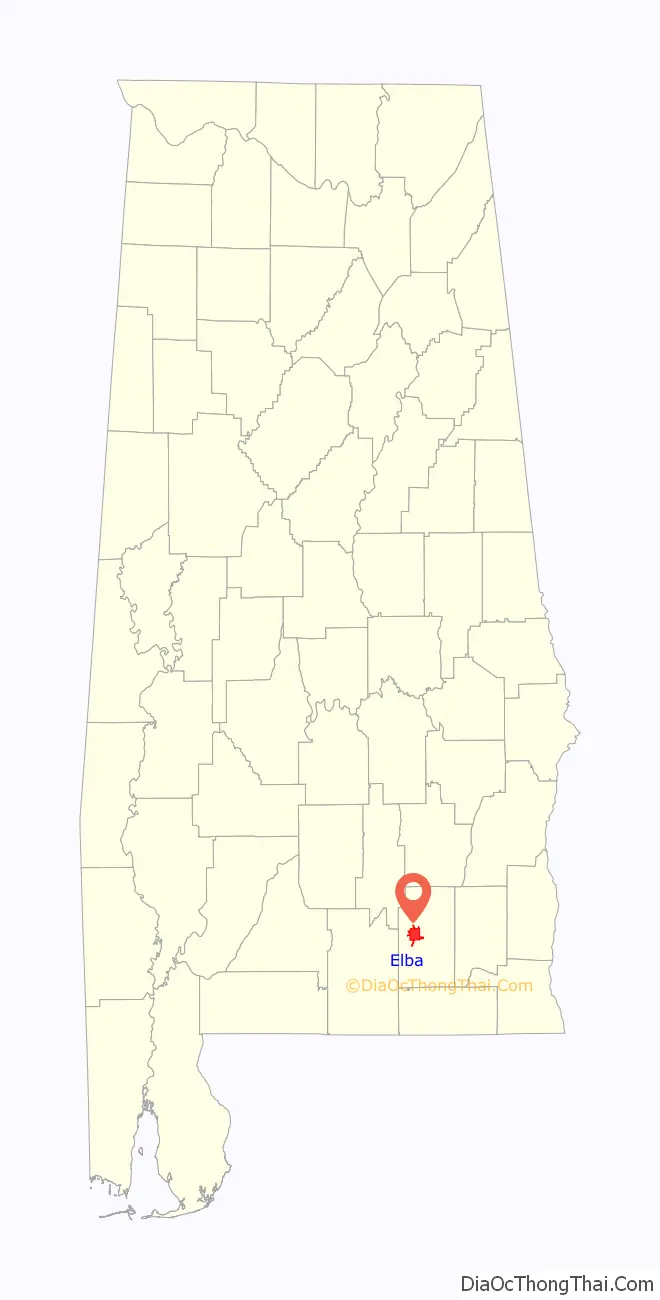
Elba location map. Where is Elba city?

History
The town which eventually became Elba originated near a ferry across the Pea River in the early 1830s. Originally called Bridgeville, a U.S. post office was established in the town by 1841. In 1851, a lottery to determine a new name for the town was held. One citizen had been reading a biography of Napoleon Bonaparte, and his suggestion of “Elba” as its name was the winner when it was drawn from a hat before any of the other suggestions. Elba became the county seat of Coffee County in 1852.
A logging railroad first reached Elba on March 20, 1892, with the first permanent rail line arriving in October 1898. The “Dorsey Trailer Company” was constructed at the end of this railroad line, and this company manufactured the highway trailers that served on railroads and highways starting with the piggyback railroad or containerized cargo boom of the second half of the 20th century. The new railroad line ended in West Elba, where the “New Town” industrial section of the town was located. The Seaboard System Railroad ceased all railroad service to Elba, including freight service, on November 27, 1984.
The Pea River is an essential component of the history of Elba. The river was originally called the Talakatchee River by the Creek Indians. (In the Creek language, talak means “pea”, and hatchee means “small river”.) The Pea River frequently flooded, causing great damage to the town. The Lincoln flood of 1865, named for the assassination of Abraham Lincoln in the same year, was the first to destroy the town. Another devastating flood occurred in 1929 when the river crested at a depth of 43.5 feet (13.3 m) early on March 15. Airplanes were used to drop supplies to the completely inundated town. There was only one death from the flood, an African-American man named “Phoe” Larkins. A child born at the Elba Hotel during this flood was named “Noah Tucker” after the biblical character Noah. Vivian Harper received the Theodore N. Vail Silver Medal for her heroic actions during the flood.
A levee was built around the town in 1930. Flood gates were erected and drainage systems improved. Floods continued, however, with especially severe inundations in 1938, 1959 and 1975. The worst flood ever recorded in Elba occurred in 1990, with a river crest of 48 feet (15 m). The levee broke and Whitewater Creek overflowed into the town. Elba was completely flooded for four days, and the town was nearly destroyed. More floods struck Elba in 1994 and 1998.
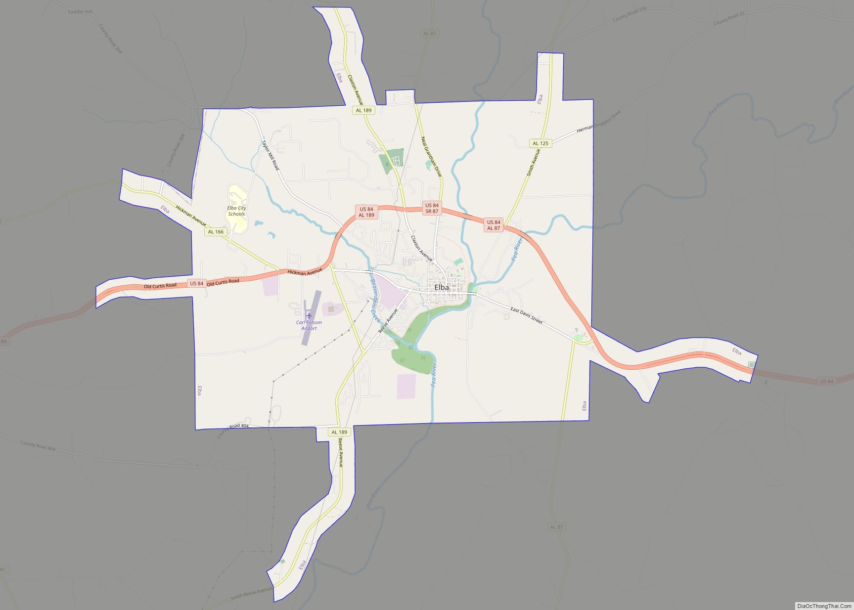
Elba Road Map
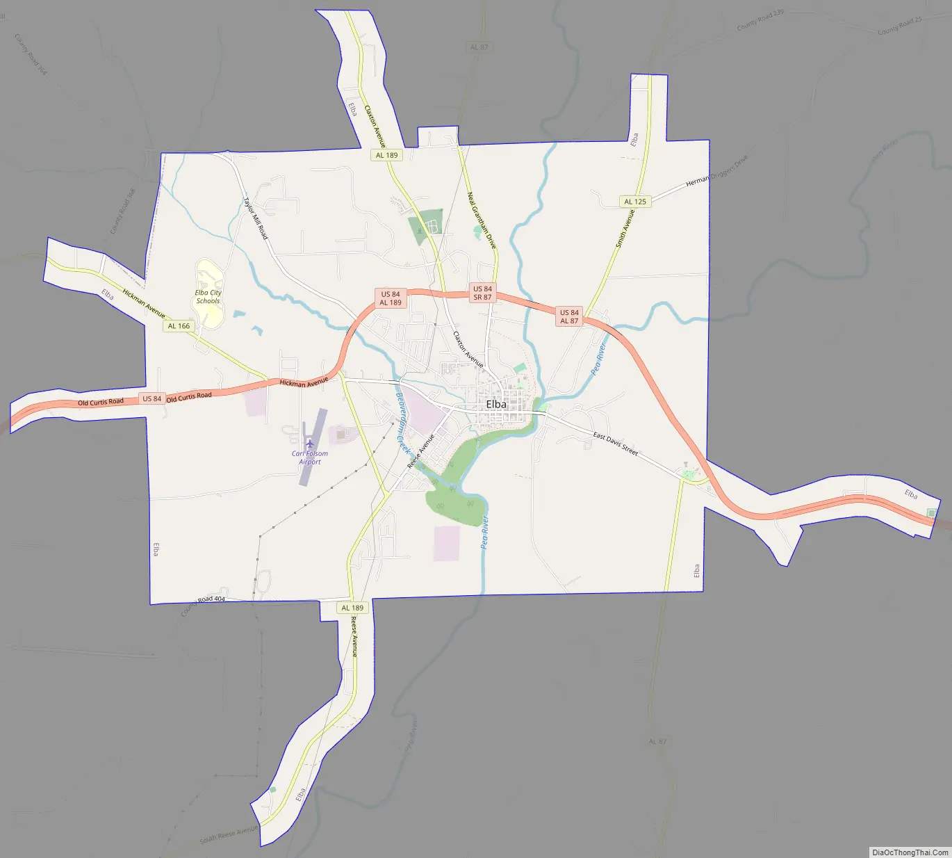
Elba city Satellite Map

Geography
Elba is located in western Coffee County at 31°25′2″N 86°4′39″W / 31.41722°N 86.07750°W / 31.41722; -86.07750 (31.417263, -86.077442).
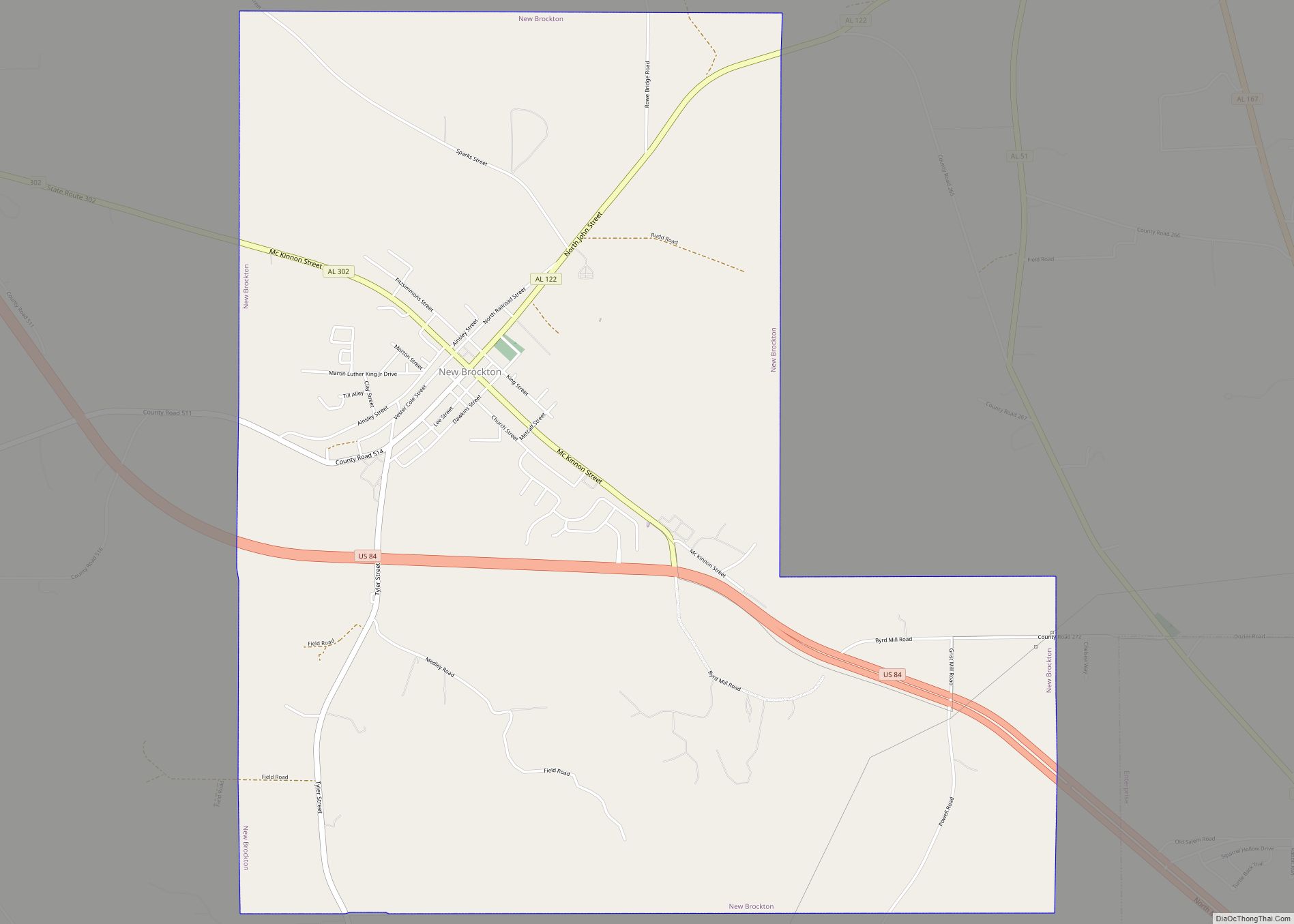
U.S. Route 84 runs from west to east as a northern bypass of the city, leading east 9 mi (14 km) to New Brockton and southwest 16 mi (26 km) to Opp. Many state highways run through the city as well, namely Alabama State Routes 87, 125, 189, and 203. AL-203 forms the western bypass of the city. AL-87 runs from south to north through the center of the city, leading north 30 mi (48 km) to Troy and south 24 mi (39 km) to Samson. AL-189 runs to the west of the city from south to north, leading northwest 16 mi (26 km) to U.S. Route 331 near Brantley and southwest 17 mi (27 km) to Kinston. AL-125 runs northeast from the city 13 mi (21 km) to the community of Victoria.
According to the U.S. Census Bureau, the city has a total area of 15.4 square miles (39.9 km), of which 15.3 square miles (39.7 km) is land and 0.077 square miles (0.2 km), or 0.52%, is water.
Elba is located beside the banks of the Pea River.
Climate
The climate in this area is characterized by hot, humid summers and generally mild to cool winters. According to the Köppen Climate Classification system, Elba has a humid subtropical climate, abbreviated “Cfa” on climate maps.
See also
Map of Alabama State and its subdivision:- Autauga
- Baldwin
- Barbour
- Bibb
- Blount
- Bullock
- Butler
- Calhoun
- Chambers
- Cherokee
- Chilton
- Choctaw
- Clarke
- Clay
- Cleburne
- Coffee
- Colbert
- Conecuh
- Coosa
- Covington
- Crenshaw
- Cullman
- Dale
- Dallas
- De Kalb
- Elmore
- Escambia
- Etowah
- Fayette
- Franklin
- Geneva
- Greene
- Hale
- Henry
- Houston
- Jackson
- Jefferson
- Lamar
- Lauderdale
- Lawrence
- Lee
- Limestone
- Lowndes
- Macon
- Madison
- Marengo
- Marion
- Marshall
- Mobile
- Monroe
- Montgomery
- Morgan
- Perry
- Pickens
- Pike
- Randolph
- Russell
- Saint Clair
- Shelby
- Sumter
- Talladega
- Tallapoosa
- Tuscaloosa
- Walker
- Washington
- Wilcox
- Winston
- Alabama
- Alaska
- Arizona
- Arkansas
- California
- Colorado
- Connecticut
- Delaware
- District of Columbia
- Florida
- Georgia
- Hawaii
- Idaho
- Illinois
- Indiana
- Iowa
- Kansas
- Kentucky
- Louisiana
- Maine
- Maryland
- Massachusetts
- Michigan
- Minnesota
- Mississippi
- Missouri
- Montana
- Nebraska
- Nevada
- New Hampshire
- New Jersey
- New Mexico
- New York
- North Carolina
- North Dakota
- Ohio
- Oklahoma
- Oregon
- Pennsylvania
- Rhode Island
- South Carolina
- South Dakota
- Tennessee
- Texas
- Utah
- Vermont
- Virginia
- Washington
- West Virginia
- Wisconsin
- Wyoming