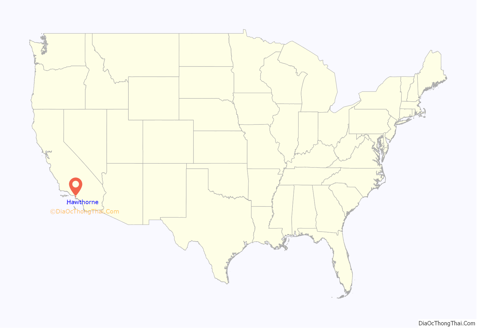
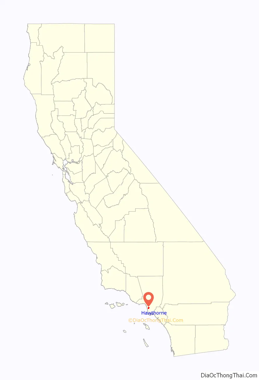
Hawthorne is a city in the Los Angeles metropolitan area, located in southwestern Los Angeles County, California. It is part of a seventeen-city region commonly called the South Bay. As of the 2020 US census, Hawthorne had a population of 88,083.
| Name: | Hawthorne city |
|---|---|
| LSAD Code: | 25 |
| LSAD Description: | city (suffix) |
| State: | California |
| County: | Los Angeles County |
| Incorporated: | July 12, 1922 |
| Elevation: | 72 ft (22 m) |
| Total Area: | 6.09 sq mi (15.78 km²) |
| Land Area: | 6.08 sq mi (15.75 km²) |
| Water Area: | 0.01 sq mi (0.03 km²) 0.18% |
| Total Population: | 88,083 |
| Population Density: | 14,000/sq mi (5,600/km²) |
| FIPS code: | 0632548 |
| Website: | cityofhawthorne.org |
Online Interactive Map
Click on ![]() to view map in "full screen" mode.
to view map in "full screen" mode.
Hawthorne location map. Where is Hawthorne city?
History
Hawthorne was founded in 1905 as the “Hawthorne Improvement Company” by B.L. Harding and H.D. Lombard. Harding’s daughter shared her birthday—the 4th of July, American Independence Day—with New England author Nathaniel Hawthorne, and a decision was made to name the city after him.
Hawthorne was once a “whites only” settlement, commonly called a sundown town. During the 1930s, signs warned African-Americans to be out of Hawthorne by sundown.
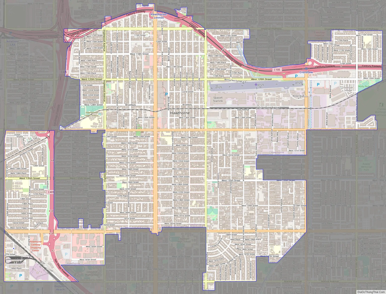
Hawthorne Road Map
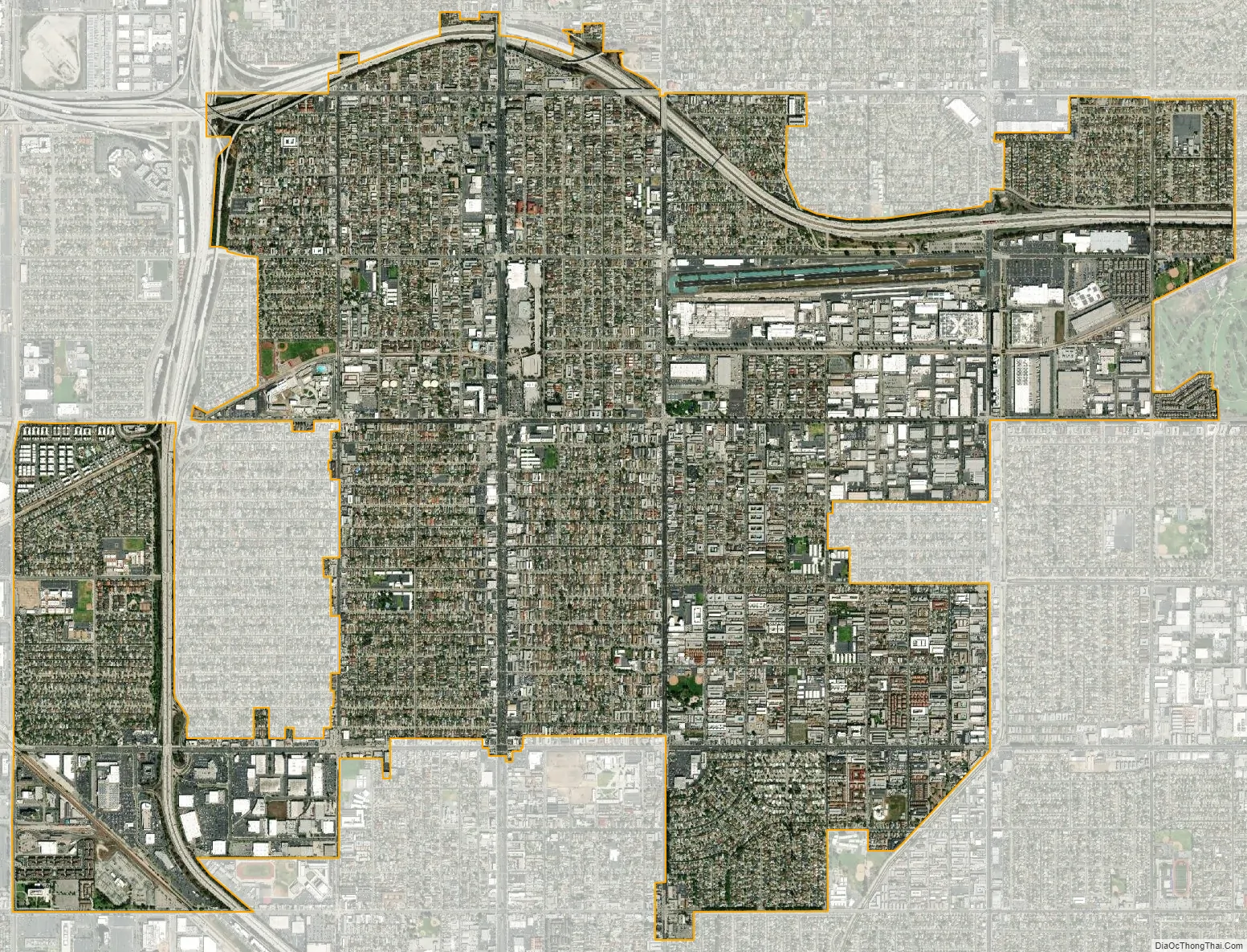
Hawthorne city Satellite Map
Geography
According to the United States Census Bureau, the city has an area of 6.1 square miles (16 km), over 99% of it land.
To the north of Hawthorne is the unincorporated community of Lennox and the city of Inglewood. To the east is the unincorporated community of Athens and the city of Gardena. To the south is the unincorporated community of El Camino Village, and the cities of Lawndale and Redondo Beach. Manhattan Beach is at the southwest corner of Hawthorne. To the west is the city of El Segundo, and the Los Angeles neighborhood of Westchester is to the northwest of Hawthorne. The unincorporated community of Del Aire is surrounded on three sides by Hawthorne.
The Century Freeway (Glenn Anderson Freeway, I-105) runs along the northern boundary of Hawthorne, with the LACMTA Green Line light rail line running down the center of the Century Freeway. The San Diego Freeway (I-405) runs along the western boundary of Hawthorne. Major east–west streets in Hawthorne include Rosecrans Avenue, El Segundo Boulevard, and Imperial Highway. Major north–south streets include Aviation Boulevard, Inglewood Avenue, Hawthorne Boulevard, Prairie Avenue, Crenshaw Boulevard, and Van Ness Avenue.
Hawthorne is five miles (8 km) from the Los Angeles International Airport.
Hawthorne comprises ZIP codes 90250 and 90251. It is in the 310 area code, except for a small portion of northeastern Hawthorne, which is located in the 323 area code.
Climate
Hawthorne, like the rest of the Los Angeles basin, has a Mediterranean climate:
- On average, the warmest month is August.
- The highest recorded temperature was 111 °F (44 °C) in 1961.
- On average, the coolest month is January.
- The lowest recorded temperature was 15 °F (−9 °C) in 1963.
- Most rainfall occurs during winter and spring.
Hawthorne has a Mediterranean climate or dry-summer subtropical (Köppen climate classification Csb on the coast, Csa inland), enjoying plenty of sunshine throughout the year, with an average of 263 sunshine days and only 35 days with measurable precipitation annually.
The period of April through November is warm to hot and dry with average high temperatures of 71–79 °F (22–26 °C) and lows of 50–62 °F (10–17 °C). Due to the moderating effect of the ocean, temperatures are cooler than more inland areas of Los Angeles, where temperatures frequently exceed 90 °F (32 °C) and occasionally reach 100 °F (38 °C).
The Los Angeles area is also subject to the phenomena typical of a microclimate. As such, the temperatures can vary as much as 18 °F (10 °C) between inland areas and the coast, with a temperature gradient of over one degree per mile (1.6 km) from the coast inland. California has also a weather phenomenon called “June Gloom or May Grey”, which sometimes brings overcast or foggy skies in the morning at the coast, but usually gives way to sunny skies by noon, during late spring and early summer.
The Los Angeles region averages 15 inches (385 mm) of precipitation annually, which mainly occurs during the winter and spring (November through April) with generally light rain showers, but sometimes as heavy rainfall and thunderstorms. On November 6, 1966, the first-ever documented tornado touched down within city limits. It caused significant damage, running for about one-half mile (0.80 km), from 132nd Street and Ramona Avenue to 140th Street and Ramona Avenue. Snowfall is extremely rare but not impossible in the city basin.
See also
Map of California State and its subdivision:- Alameda
- Alpine
- Amador
- Butte
- Calaveras
- Colusa
- Contra Costa
- Del Norte
- El Dorado
- Fresno
- Glenn
- Humboldt
- Imperial
- Inyo
- Kern
- Kings
- Lake
- Lassen
- Los Angeles
- Madera
- Marin
- Mariposa
- Mendocino
- Merced
- Modoc
- Mono
- Monterey
- Napa
- Nevada
- Orange
- Placer
- Plumas
- Riverside
- Sacramento
- San Benito
- San Bernardino
- San Diego
- San Francisco
- San Joaquin
- San Luis Obispo
- San Mateo
- Santa Barbara
- Santa Clara
- Santa Cruz
- Shasta
- Sierra
- Siskiyou
- Solano
- Sonoma
- Stanislaus
- Sutter
- Tehama
- Trinity
- Tulare
- Tuolumne
- Ventura
- Yolo
- Yuba
- Alabama
- Alaska
- Arizona
- Arkansas
- California
- Colorado
- Connecticut
- Delaware
- District of Columbia
- Florida
- Georgia
- Hawaii
- Idaho
- Illinois
- Indiana
- Iowa
- Kansas
- Kentucky
- Louisiana
- Maine
- Maryland
- Massachusetts
- Michigan
- Minnesota
- Mississippi
- Missouri
- Montana
- Nebraska
- Nevada
- New Hampshire
- New Jersey
- New Mexico
- New York
- North Carolina
- North Dakota
- Ohio
- Oklahoma
- Oregon
- Pennsylvania
- Rhode Island
- South Carolina
- South Dakota
- Tennessee
- Texas
- Utah
- Vermont
- Virginia
- Washington
- West Virginia
- Wisconsin
- Wyoming


