The Town of Pagosa Springs (Ute language: Pagwöösa, Navajo language: Tó Sido Háálį́) is a home rule municipality that is the county seat, the most populous community, and the only incorporated municipality in Archuleta County, Colorado, United States. The population was 1,571 at the 2020 census. Approximately 65 percent of the land in Archuleta County is either San Juan National Forest, Weminuche and South San Juan wilderness areas, or Southern Ute Indian reservation land.
Pagosa Springs and the surrounding county are both experiencing a substantial influx of second-home owners; a 2006 property assessment indicated that 60% of area private properties are owned by non-residents.
Pagosa Springs is located approximately 35 miles (56 km) north of the New Mexico border, at 7,126 feet (2,172 m) above sea level on the Western Slope of the Continental Divide. This combination of high desert plateau and the Rocky Mountains to the north and east creates an unusually mild climate, especially in the summer months. Pagosa sees around 300 days of sun each year, as well as four distinct seasons.
The town is located in the upper San Juan Basin, surrounded by the 3-million-acre (4,700 sq mi; 12,000 km) San Juan National Forest, and adjacent to the largest wilderness area in the state of Colorado, the Weminuche Wilderness.
The town is named for a system of sulfur springs, Pagosa hot springs, located there, which includes the world’s deepest geothermal hot spring. The “Mother” spring feeds primitive and developed hot springs located on the upper banks of the San Juan River, which flows through town. The primitive springs are freely accessible to the public, but are generally not for entering or interacting with because of the extreme water temperature. Developed springs feed soaking pools that are hosted by three privately-owned soaking locations within town. The water from the “Mother” spring is approximately 144 °F (62 °C).
| Name: | Pagosa Springs town |
|---|---|
| LSAD Code: | 43 |
| LSAD Description: | town (suffix) |
| State: | Colorado |
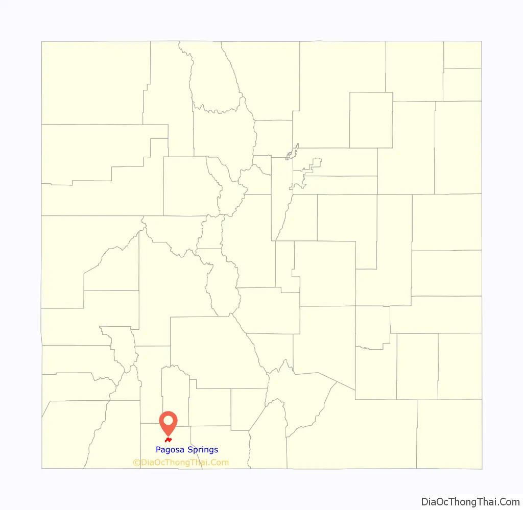
| County: | Archuleta County |
| Elevation: | 7,126 ft (2,172 m) |
| Total Area: | 5.06 sq mi (13.10 km²) |
| Land Area: | 5.03 sq mi (13.04 km²) |
| Water Area: | 0.03 sq mi (0.07 km²) |
| Total Population: | 1,571 |
| Population Density: | 310/sq mi (120/km²) |
| Area code: | 970 |
| FIPS code: | 0856860 |
| Website: | visitpagosasprings.com |
Online Interactive Map
Click on ![]() to view map in "full screen" mode.
to view map in "full screen" mode.
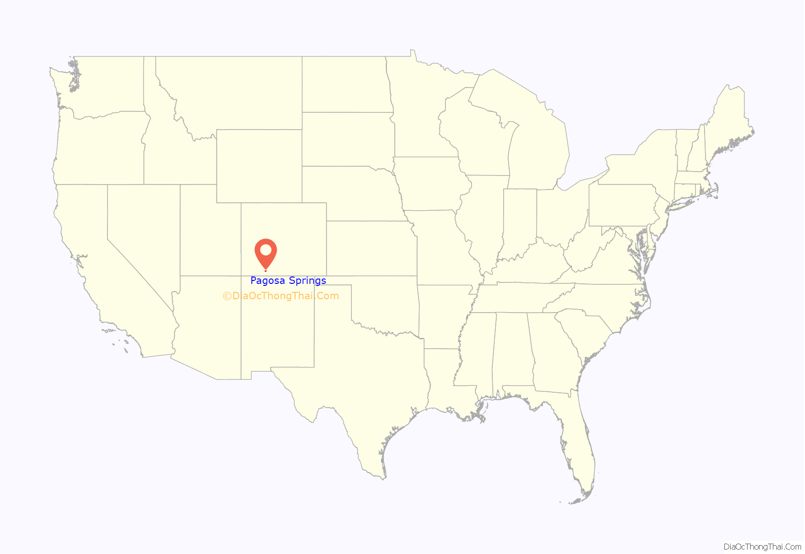
Pagosa Springs location map. Where is Pagosa Springs town?
History
Local indigenous people used the hot springs for centuries; the area was considered “sacred ground”. In Navajo cosmology, Pagosa Springs is the place where the People (Diné) emerged from their Fourth World underground to the Fifth World, this one, as Aileen O’Bryan records in The Dîné: Origin Myths of the Navaho Indians. In 1859, a white settler “discovered” the springs and exploited them. In 1881, a bathhouse was first built there for paying customers.
The Ute people called the sulfur-rich mineral springs Pah gosah, which is commonly translated in modern documents as “healing waters”; a Ute elder once translated the phrase as “water (pah) that has a bad smell (gosah).”
After the Civil War, the United States government considered building a convalescent hospital in Pagosa Springs. However, the hospital project was cancelled, and the lands platted by the U.S. Army were sold to private parties who capitalized on the thermal mineral springs. Along the banks of the San Juan river, simple wooden bathhouses were constructed.
In the late 1880s, Dr. Mary Winter Fisher ventured west from Chicago to found a medical and healing practice in Pagosa Springs. The medical center in the town is named in her honor.
In the 1930s, Cora Woods built a geothermal swimming pool and several small cabins on the Northeast corner of land she purchased from Bill Lynn, a local entrepreneur. There were a total of 23 cabins with no electricity, dirt floors, wood stoves, and oak iceboxes. In the 1950s, the Giordano family purchased the property from Cora Woods. The Giordanos were European coal miners who had settled in the Walsenburg, Colorado area. They dug additional geothermal wells, and built an enclosed bathhouse next to the thermal water swimming pool.
In the 1980s, Pagosa Springs received federal funding from the Department of Energy to drill two geothermal wells to heat buildings in the small downtown area of the town. In the 1990s, the town built a new pipeline and municipal bridge to deliver mineral springs water to a new resort.
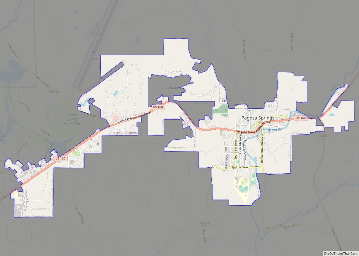
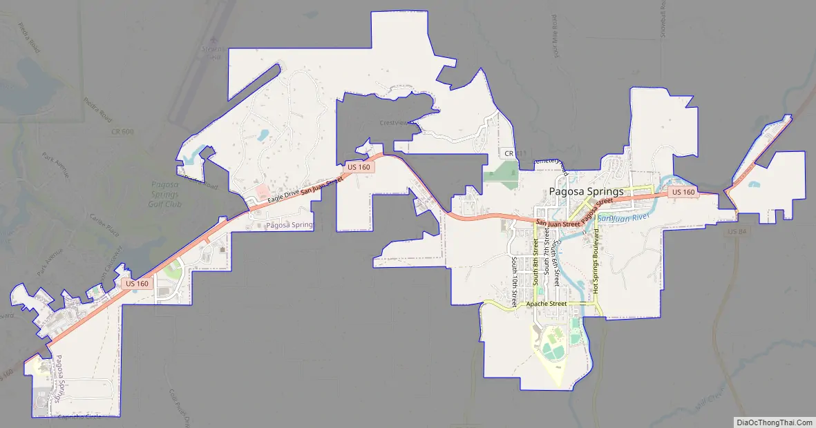
Pagosa Springs Road Map
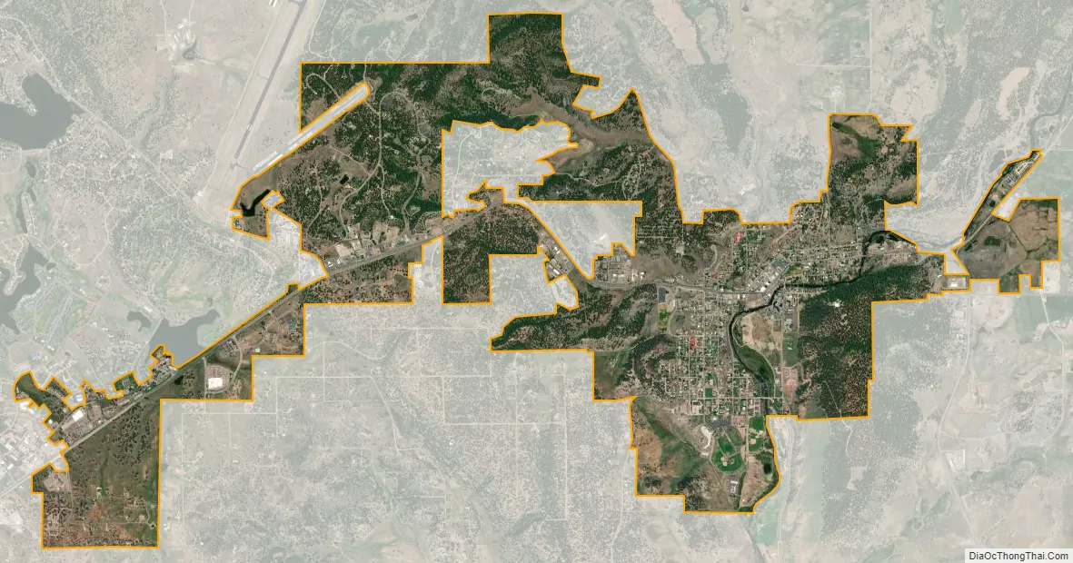
Pagosa Springs city Satellite Map
Geography
Pagosa Springs is located 47 miles (75 km) east of Durango. The San Juan River flows through the middle of town.
According to the United States Census Bureau, the town has a total area of 4.88 square miles (12.64 km), of which 4.85 square miles (12.57 km) is land and 0.027 square miles (0.07 km), or 0.53%, is water. The area around Pagosa Springs has numerous large waterfalls, including Treasure Falls to the east of town off of Hwy 160 just past the Wolf Creek Pass summit.
See also
Map of Colorado State and its subdivision:- Adams
- Alamosa
- Arapahoe
- Archuleta
- Baca
- Bent
- Boulder
- Broomfield
- Chaffee
- Cheyenne
- Clear Creek
- Conejos
- Costilla
- Crowley
- Custer
- Delta
- Denver
- Dolores
- Douglas
- Eagle
- El Paso
- Elbert
- Fremont
- Garfield
- Gilpin
- Grand
- Gunnison
- Hinsdale
- Huerfano
- Jackson
- Jefferson
- Kiowa
- Kit Carson
- La Plata
- Lake
- Larimer
- Las Animas
- Lincoln
- Logan
- Mesa
- Mineral
- Moffat
- Montezuma
- Montrose
- Morgan
- Otero
- Ouray
- Park
- Phillips
- Pitkin
- Prowers
- Pueblo
- Rio Blanco
- Rio Grande
- Routt
- Saguache
- San Juan
- San Miguel
- Sedgwick
- Summit
- Teller
- Washington
- Weld
- Yuma
- Alabama
- Alaska
- Arizona
- Arkansas
- California
- Colorado
- Connecticut
- Delaware
- District of Columbia
- Florida
- Georgia
- Hawaii
- Idaho
- Illinois
- Indiana
- Iowa
- Kansas
- Kentucky
- Louisiana
- Maine
- Maryland
- Massachusetts
- Michigan
- Minnesota
- Mississippi
- Missouri
- Montana
- Nebraska
- Nevada
- New Hampshire
- New Jersey
- New Mexico
- New York
- North Carolina
- North Dakota
- Ohio
- Oklahoma
- Oregon
- Pennsylvania
- Rhode Island
- South Carolina
- South Dakota
- Tennessee
- Texas
- Utah
- Vermont
- Virginia
- Washington
- West Virginia
- Wisconsin
- Wyoming