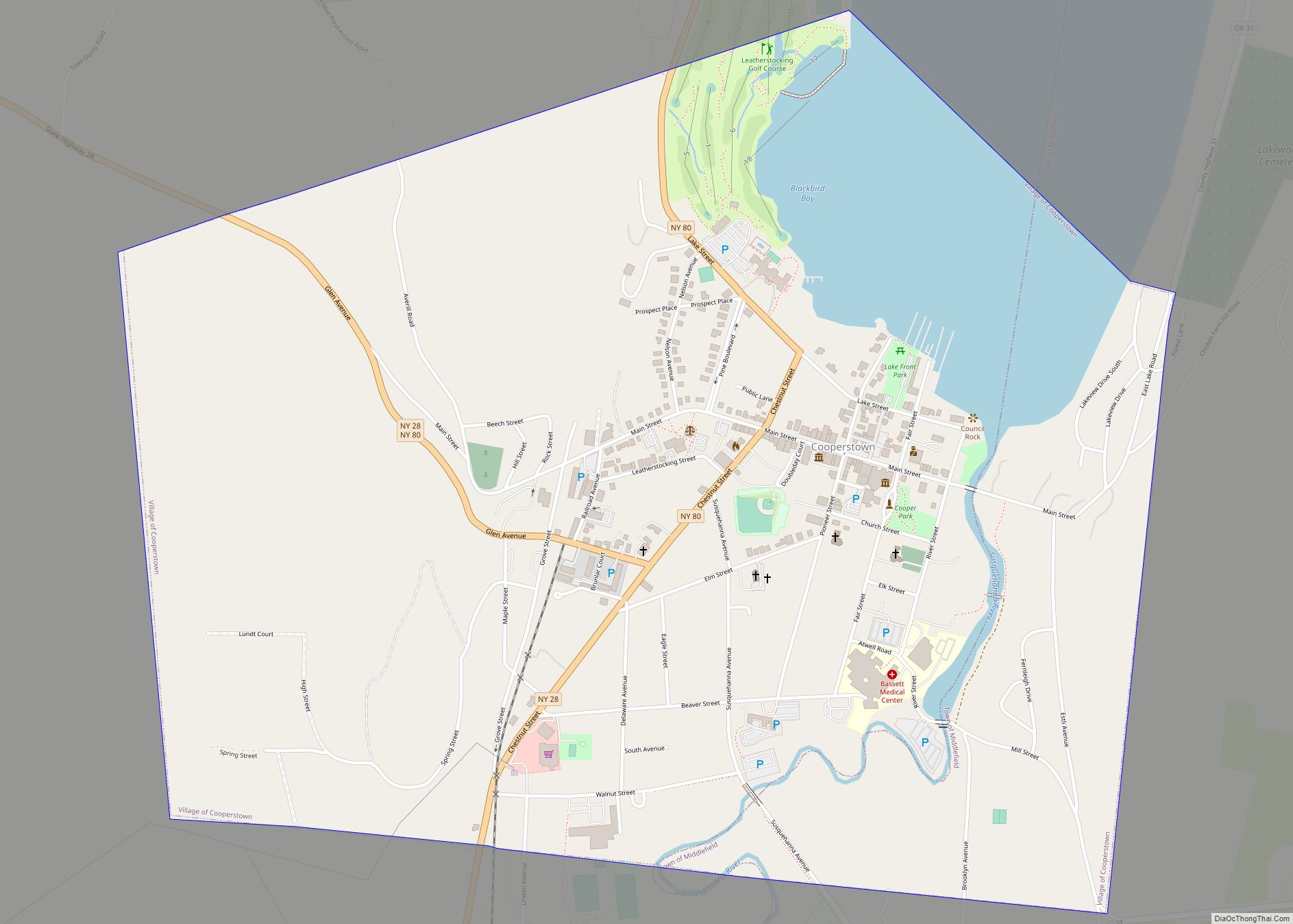
Cooperstown is a village in and the county seat of Otsego County, New York, United States. Most of the village lies within the town of Otsego, but some of the eastern part is in the town of Middlefield. Located at the foot of Otsego Lake in the Central New York Region, Cooperstown is approximately 60 miles (97 kilometers) southwest of Albany, 67 mi (108 km) southeast of Syracuse and 145 mi (233 km) northwest of New York City. The population of the village was 1,794 as of the 2020 census.
Cooperstown is the home of the National Baseball Hall of Fame and Museum. The Farmers’ Museum in the village opened in 1944 on farmland that had once belonged to James Fenimore Cooper. The Fenimore Art Museum and Glimmerglass Opera are also based here. Most of the historic pre-1900s core of the village is included in the Cooperstown Historic District, which was listed on the National Register of Historic Places in 1980; its boundaries were increased in 1997 and more contributing properties were identified.
| Name: | Cooperstown village |
|---|---|
| LSAD Code: | 47 |
| LSAD Description: | village (suffix) |
| State: | New York |
| County: | Otsego County |
| Elevation: | 1,227 ft (374 m) |
| Total Area: | 1.84 sq mi (4.78 km²) |
| Land Area: | 1.64 sq mi (4.23 km²) |
| Water Area: | 0.21 sq mi (0.54 km²) |
| Total Population: | 1,794 |
| Population Density: | 1,097.25/sq mi (423.74/km²) |
| ZIP code: | 13326 |
| Area code: | 607 |
| FIPS code: | 3618047 |
| GNISfeature ID: | 0979671 |
| Website: | www.cooperstownny.org |
Online Interactive Map
Click on ![]() to view map in "full screen" mode.
to view map in "full screen" mode.
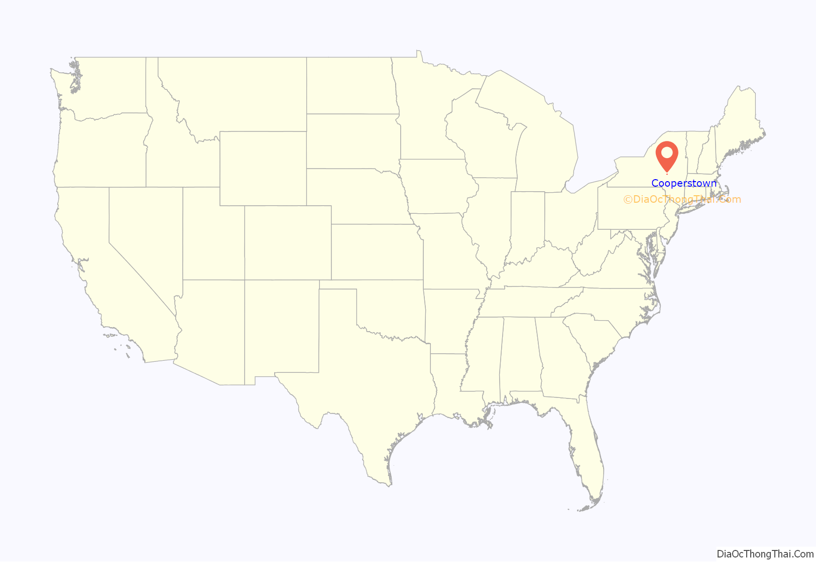
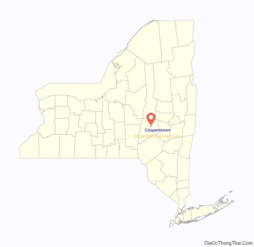
Cooperstown location map. Where is Cooperstown village?
History
Native American use
Before European colonization, Iroquois Indians inhabited the area around the village and Otsego Lake. The name Otsego is from a Mohawk or Oneida word meaning “place of the rock”, referring to the large boulder near the lake’s outlet, today known as “Council Rock”. It is a large boulder whose top is above the water’s surface and can be seen from shore. It is believed to have been a meeting place for Native Americans prior to the American Revolutionary War. A small parcel of land near Council Rock was presented to the Village of Cooperstown in 1957, on the condition that it remain open to the public as a park.
Settlement
The village was developed within part of the Cooper Patent, which William Cooper – who later became a county judge – purchased in 1785 from Colonel George Croghan, former Deputy to Sir William Johnson, British Superintendent of Indian Affairs of the Northern District. The land amounted to 10,000 acres (40 km). William Cooper founded a village on Otsego Lake. His son, James Fenimore Cooper, grew up in the frontier town. He later became a noted American author with The Leatherstocking Tales, a series of novels that includes The Last of the Mohicans.
Cooper established the village of Cooperstown in 1786, laid out by surveyor William Ellison. At the time, the area was part of Montgomery County. It was incorporated as the “Village of Otsego” on April 3, 1807. The name was changed to “Village of Cooperstown” June 12, 1812, after the founder. William Cooper was appointed as a county judge in the late 18th century and was elected to the state assembly from Otsego County.
Cooperstown is one of only twelve villages in New York still incorporated under a charter, the other villages having incorporated or re-incorporated under the provisions of Village Law.
Cooperstown today
Cooperstown is best known as the home of the National Baseball Hall of Fame and Museum, which was founded in 1939 by Stephen Carlton Clark. According to an interview conducted in 1906 by the Mills Commission, nearby resident Abner Graves attributed the game’s invention to his deceased friend, Abner Doubleday. Graves stated that Doubleday invented baseball on a cow pasture within the village in 1839, the present site of Doubleday Field, but this claim is universally discounted by baseball historians.
Once known as the “Village of Museums”, until the 1970s Cooperstown also boasted the Indian Museum (adjacent to Lakefront Park), The Carriage and Harness Museum (displaying a world-class collection primarily from F. Ambrose Clark’s estate; now the Bassett Hospital offices on Elk Street), and The Woodland Museum near Three Mile Point. The latter, opened in 1962 by heirs to the Anheuser-Busch company, folded in 1974. It ran a close third in annual attendance to the Hall of Fame and Farmers’ Museum.
The Cooperstown Historic District, Glimmerglass Historic District, Middlefield District No. 1 School, Fly Creek Historic District, Otsego County Courthouse, and United States Post Office are listed on the National Register of Historic Places.
Business district
Superficially, the downtown commercial district looks not unlike it did in the 1970s. It has undergone significant change since the late 20th century.
Through the 1970s, Main Street was still home to at least five grocery stores, including an A&P. Western Auto had a branch on Main Street and J.J. Newberry’s had built, in 1960, a two-story five-and-dime with a fountain and lunch counter. Smalley’s, a stage theater converted into a movie theater, had a single screen across from a Farm & Home store. With its post office, library, and the Baseball Hall of Fame, Main Street resembled a true village square.
Today, the village has fewer traditional services for year-round and seasonal residents. Once boasting half a dozen gas stations, the village now has two. Traditional grocers have been reduced to one, and in 1977 Great American was built on the outskirts of town, replacing the town’s bowling alley.
In 2010, it was converted to a Price Chopper. Hardware stores such as Western Auto, McGown’s and Farm & Home have been displaced by an Ace Hardware just outside the village. Newberry’s morphed into a single-floor general store with the basement stairs boarded up, and even this general store finally closed entirely in 2017. Sherry’s Famous Restaurant closed in the late 1990s after more than half a century of business. Most Main Street shops now cater to the tourist trade and feature gifts and souvenirs.
The Cooperstown Chamber of Commerce, established in 1917, looks to develop business and trade in the Cooperstown region. Serving also as a visitor center in its main office, the Chamber also manages a seasonal kiosk on the corner of Main and Pioneer St for tourists.
Cooperstown was formerly served by the Cooperstown Municipal Airport, which was a two-runway facility fewer than two miles to the northwest of town center. That field closed in the 1960s. The village is now served by a small grass field in nearby Westville and a larger paved one-runway facility in Oneonta.
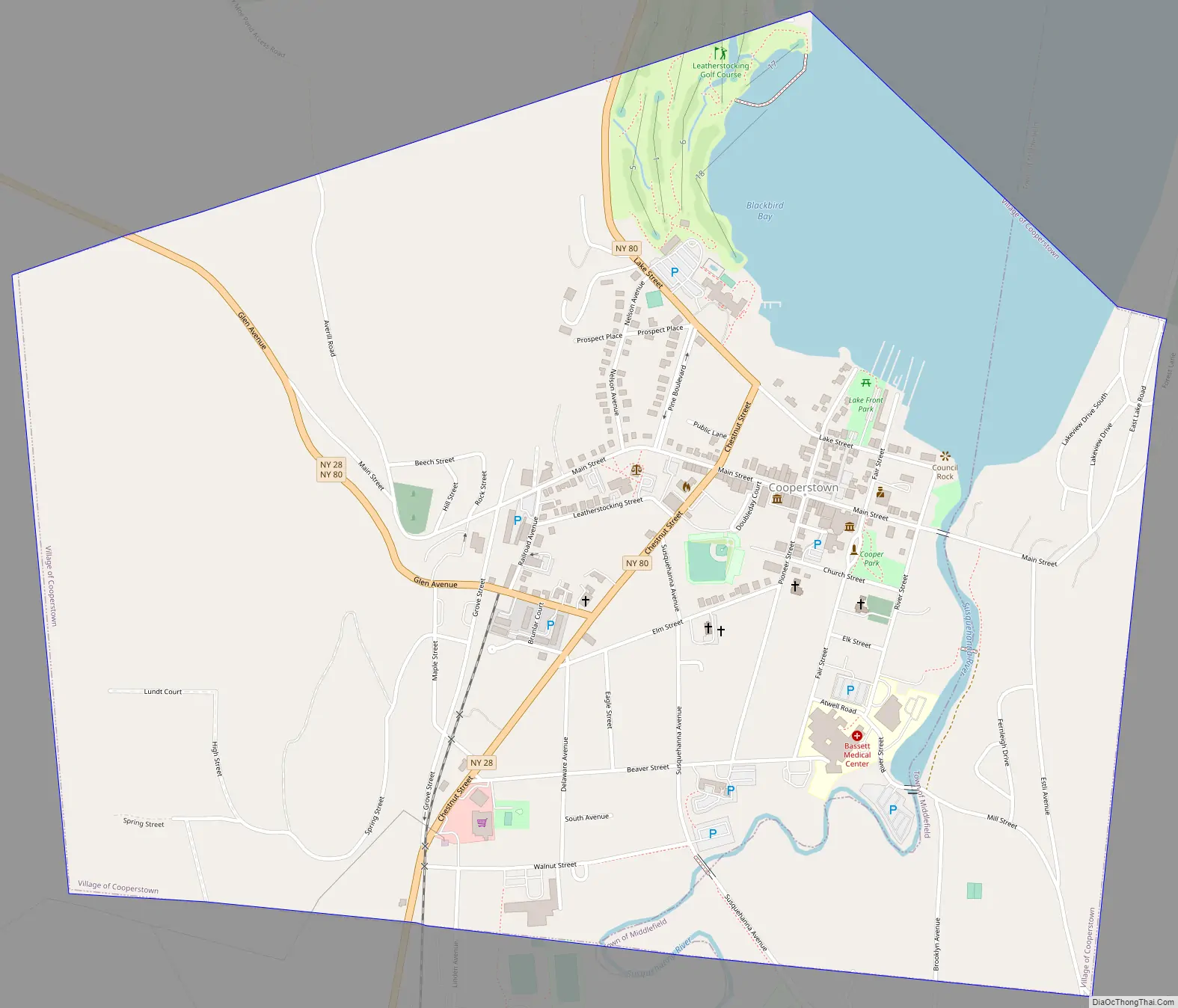
Cooperstown Road Map
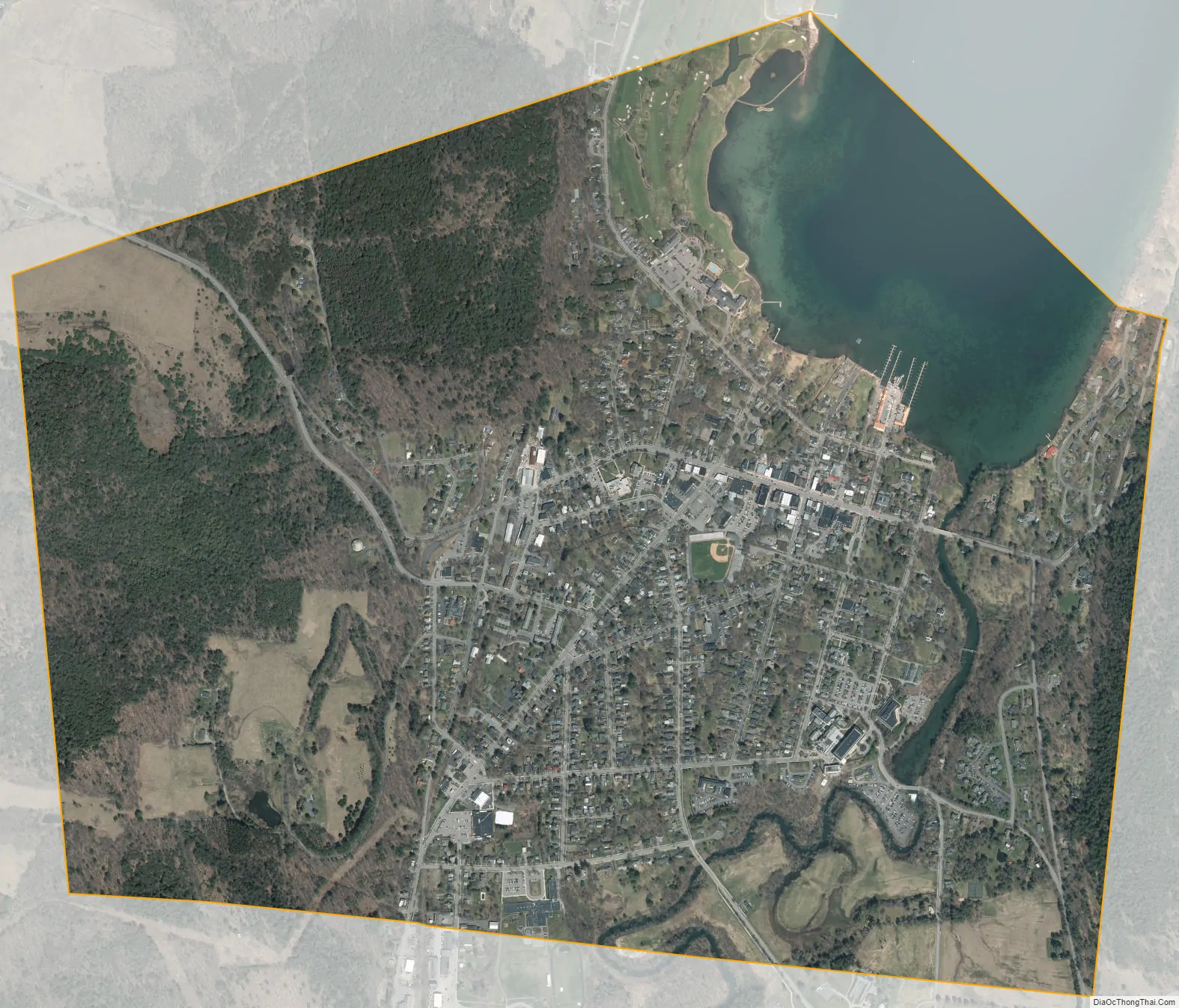
Cooperstown city Satellite Map
Geography
According to the United States Census Bureau, the village has a total area of 1.6 square miles (4.1 km), of which 1.5 square miles (3.9 km) is land and 0.04 square miles (0.10 km) (2.53%) is water.
The source of the Susquehanna River is in Cooperstown at the outlet of Otsego Lake. Blackbird Bay of Otsego Lake is north of the village.
The junction of New York State Route 28 and New York State Route 80 was constructed at Cooperstown. The village is also served by County Routes 31 and 33.
Climate
Cooperstown has a humid continental climate (Dfb), with cold, very snowy winters, warm summers, and abundant precipitation year-round. Freezing temperatures have been observed in every month of the year, except for July. The record low temperature is −34 °F (−37 °C), set on February 9, 1934, and the record high temperature is 99 °F (37 °C), set on July 9 and 10, 1936.
See also
Map of New York State and its subdivision:- Albany
- Allegany
- Bronx
- Broome
- Cattaraugus
- Cayuga
- Chautauqua
- Chemung
- Chenango
- Clinton
- Columbia
- Cortland
- Delaware
- Dutchess
- Erie
- Essex
- Franklin
- Fulton
- Genesee
- Greene
- Hamilton
- Herkimer
- Jefferson
- Kings
- Lake Ontario
- Lewis
- Livingston
- Madison
- Monroe
- Montgomery
- Nassau
- New York
- Niagara
- Oneida
- Onondaga
- Ontario
- Orange
- Orleans
- Oswego
- Otsego
- Putnam
- Queens
- Rensselaer
- Richmond
- Rockland
- Saint Lawrence
- Saratoga
- Schenectady
- Schoharie
- Schuyler
- Seneca
- Steuben
- Suffolk
- Sullivan
- Tioga
- Tompkins
- Ulster
- Warren
- Washington
- Wayne
- Westchester
- Wyoming
- Yates
- Alabama
- Alaska
- Arizona
- Arkansas
- California
- Colorado
- Connecticut
- Delaware
- District of Columbia
- Florida
- Georgia
- Hawaii
- Idaho
- Illinois
- Indiana
- Iowa
- Kansas
- Kentucky
- Louisiana
- Maine
- Maryland
- Massachusetts
- Michigan
- Minnesota
- Mississippi
- Missouri
- Montana
- Nebraska
- Nevada
- New Hampshire
- New Jersey
- New Mexico
- New York
- North Carolina
- North Dakota
- Ohio
- Oklahoma
- Oregon
- Pennsylvania
- Rhode Island
- South Carolina
- South Dakota
- Tennessee
- Texas
- Utah
- Vermont
- Virginia
- Washington
- West Virginia
- Wisconsin
- Wyoming