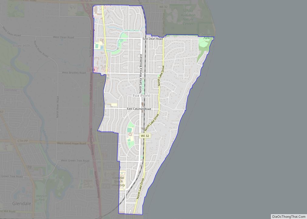
Fox Point is a village in Milwaukee County, Wisconsin, United States. The population was 6,934 at the 2020 census.
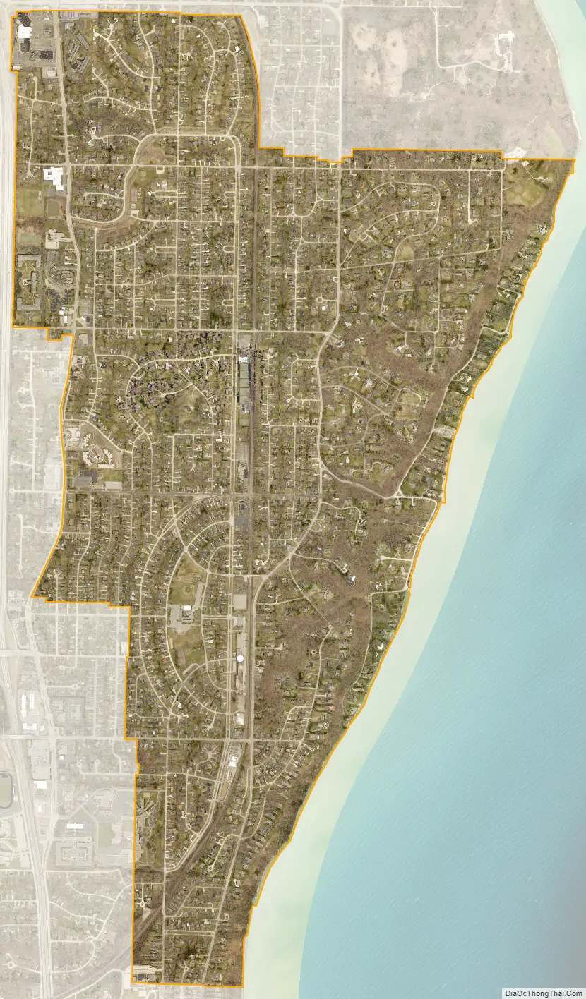
Located on the western shore of Lake Michigan, Fox Point is one of the North Shore suburbs of the Milwaukee metropolitan area. The village is primarily residential. Shopping centers include Fox Point Shops, and RiverPoint Shopping Center.
| Name: | Fox Point village |
|---|---|
| LSAD Code: | 47 |
| LSAD Description: | village (suffix) |
| State: | Wisconsin |
| County: | Milwaukee County |
| Incorporated: | 1926 |
| Elevation: | 686 ft (209 m) |
| Total Area: | 2.86 sq mi (7.41 km²) |
| Land Area: | 2.86 sq mi (7.41 km²) |
| Water Area: | 0.00 sq mi (0.00 km²) |
| Total Population: | 6,934 |
| Population Density: | 2,424/sq mi (936/km²) |
| Area code: | 414 |
| FIPS code: | 5527075 |
| GNISfeature ID: | 1565227 |
| Website: | villageoffoxpoint.com |
Online Interactive Map
Click on ![]() to view map in "full screen" mode.
to view map in "full screen" mode.
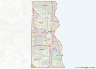
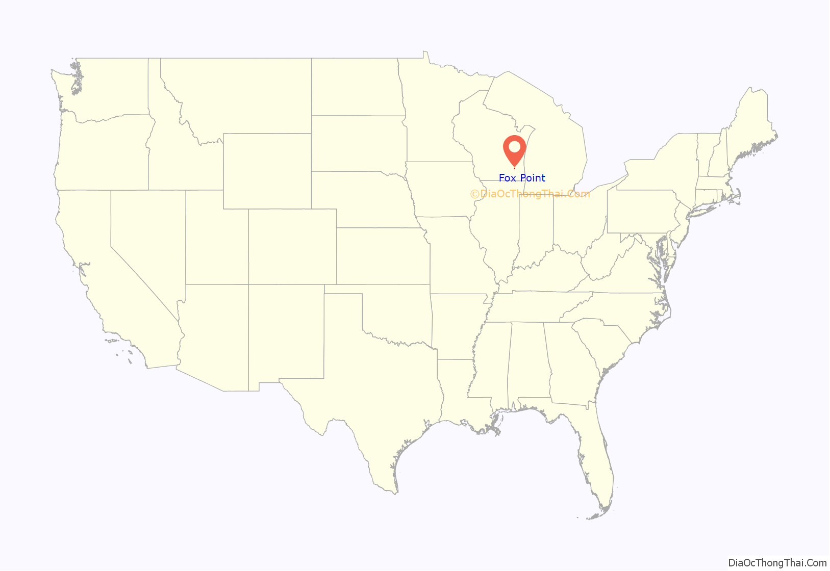
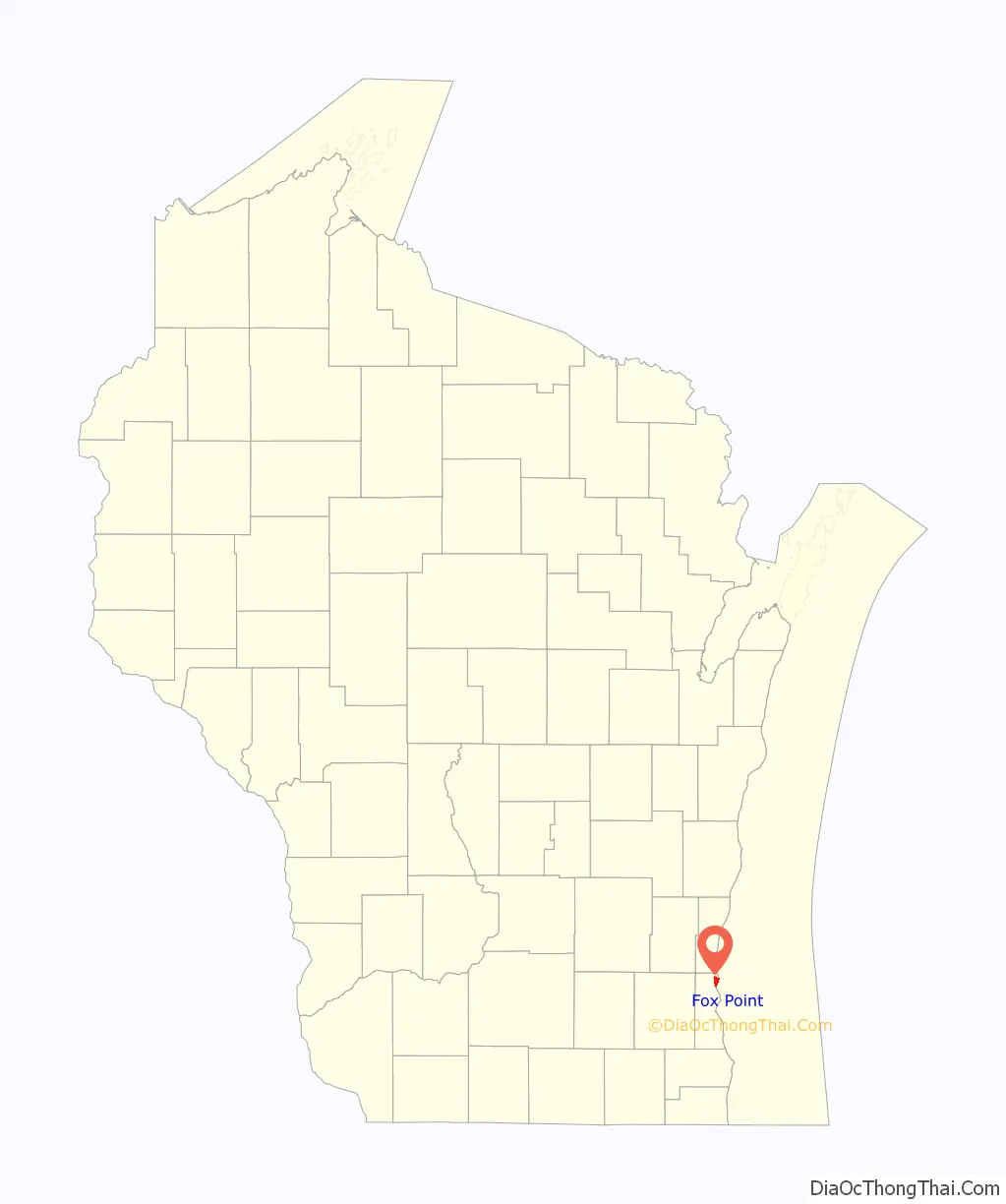
Fox Point location map. Where is Fox Point village?
History
The Fox Point area has been inhabited for thousands of years. The earliest known inhabitants were Woodland period Mound Builders, who constructed earthen effigy and burial mounds in the area. Many of the mounds were destroyed by white farmers between 1850 and 1920. In the early 19th century, archaeologists also found traces of several Hopewell villages in the area.
The land was opened to European and American settlers in the 1830s, after the Potawatomi signed the 1833 Treaty of Chicago. The first survey of the area was conducted later that year, and the U.S. Federal Government began land parcels in present-day Fox Point in autumn 1835. Surveyors in the mid-nineteenth century noted a point that resembled a fox’s snout jutting into Lake Michigan at the present location of Doctor’s Park in the village. They originally called it “Foxes Point” before residents eventually shortened it to “Fox Point.”
The land was organized as part of the Town of Milwaukee in 1835, and much of the land was bought by land speculators, who cleared the old-growth forests for timber. The first permanent settler in the area was Cephas Buttles, who owned 160 acres in the Town of Milwaukee and built a cabin in present-day River Hills in 1843. In the mid-1840s, many families of Dutch settlers began arriving in the Town of Milwaukee. John Cappon was the first Dutch settler in Fox Point, building his cabin in 1846. By 1855, more than 20 Dutch families lived in Fox Point. The early settlers farmed the land with new techniques that allowed them to cultivate wheat, barley, rye, and corn in the clayey soil. In 1848, they built a one one-room schoolhouses and another two in 1852, including the Old Dutch Schoolhouse Site and Burial Ground, which is a Milwaukee County landmark. Two Dutch Reformed congregations formed in the community in its early years. The community’s demographics changed later in the nineteenth century. One of Fox Point’s first black residents was Calvin Reeves, a formerly enslaved man from Louisiana who moved to the community after the American Civil War with two Dutch-American soldiers returning home from the conflict. German immigrants also began moving to Fox Point in the 1860s, forming St. John’s Lutheran Church in 1866.
Fox Point changed significantly in the 1890s. Many of the originally Dutch farmers had moved to the City of Milwaukee and to the southern Sheboygan County Town of Holland, and the villages of Oostburg and Cedar Grove. By 1898, the Dutch churches had disbanded. But at the same time, wealthy Milwaukeeans were building summer homes in the lakeside community, which was easily accessible via the Lakeshore & Western Railroad constructed in 1870 and later via the Milwaukee Electric Railway and Light Company streetcars. In 1898, the Fox Point Club—the state’s second golf course—opened in the community, and attracted even more wealthy residents to the area, serving as a social center.
The rural Town of Milwaukee did not provide electricity, running water, sewage, or garbage collection, and by the 1920s, Fox Point’s increasingly wealthy residents wanted a higher standard of municipal service. Fox Point incorporated as a village in 1926, formed a school district in 1927, and began creating municipal parks, including Doctors Park on the Lake Michigan shore, which opened in 1930 and was transferred to the Milwaukee County parks system in 1937.
Although the late 1920s saw a short-lived building boom before the Great Depression, the population remained in the hundreds through World War II. But the village dramatically grew during the post-war boom with the population increasing from 1,180 in 1940 to 7,939 in 1970, a nearly seven-fold increase. The village also gained territory in 1954, when Bayside, Fox Point, Glendale, and River Hills agreed to annex what remained of the Town of Milwaukee to prevent the City of Milwaukee from expanding across northeastern Milwaukee County.
Fox Point Road Map
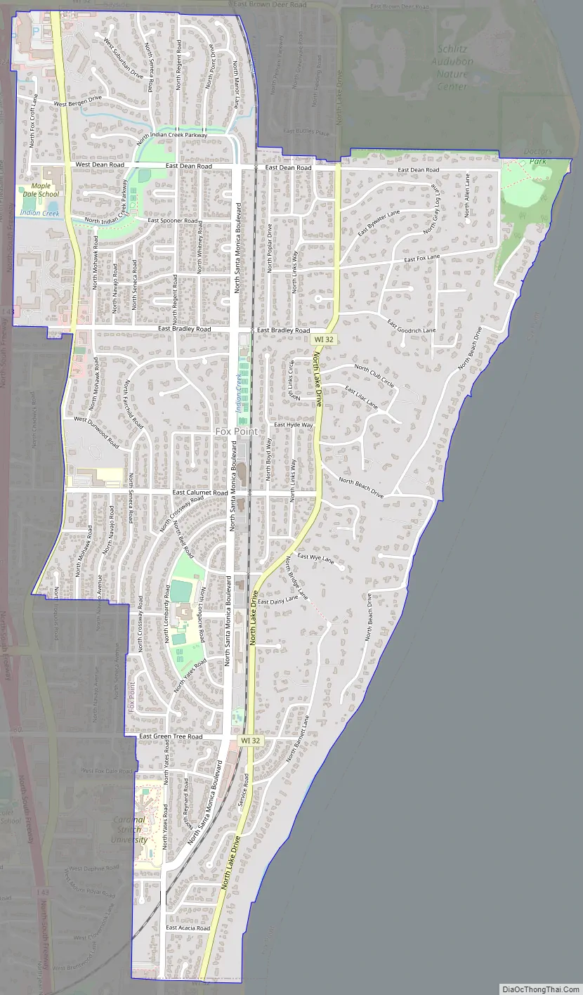
Fox Point city Satellite Map
Geography
According to the United States Census Bureau, the village has a total area of 2.90 square miles (7.51 km), all of it land.
Climate
Fox Point, situated within the humid continental climate zone (Köppen prefix D), experiences distinct seasonal variation, with wide swings in temperature and precipitation. The village’s immediate proximity to Lake Michigan makes it susceptible to lake-effect snow in the winter months.
The warmest month of the year in Fox Point is July, with a high temperature average of 84 °F (28.9 °C) and low temperatures of 64 °F (17.8 °C). The summer months are the wettest months of the year, with frequent thunderstorms in the region. January is the coldest month, with average high temperatures averaging only 30 °F (-1.1 °C), and lows averaging 14 °F (-10 °C). February is the driest month.
See also
Map of Wisconsin State and its subdivision:- Adams
- Ashland
- Barron
- Bayfield
- Brown
- Buffalo
- Burnett
- Calumet
- Chippewa
- Clark
- Columbia
- Crawford
- Dane
- Dodge
- Door
- Douglas
- Dunn
- Eau Claire
- Florence
- Fond du Lac
- Forest
- Grant
- Green
- Green Lake
- Iowa
- Iron
- Jackson
- Jefferson
- Juneau
- Kenosha
- Kewaunee
- La Crosse
- Lafayette
- Lake Michigan
- Lake Superior
- Langlade
- Lincoln
- Manitowoc
- Marathon
- Marinette
- Marquette
- Menominee
- Milwaukee
- Monroe
- Oconto
- Oneida
- Outagamie
- Ozaukee
- Pepin
- Pierce
- Polk
- Portage
- Price
- Racine
- Richland
- Rock
- Rusk
- Saint Croix
- Sauk
- Sawyer
- Shawano
- Sheboygan
- Taylor
- Trempealeau
- Vernon
- Vilas
- Walworth
- Washburn
- Washington
- Waukesha
- Waupaca
- Waushara
- Winnebago
- Wood
- Alabama
- Alaska
- Arizona
- Arkansas
- California
- Colorado
- Connecticut
- Delaware
- District of Columbia
- Florida
- Georgia
- Hawaii
- Idaho
- Illinois
- Indiana
- Iowa
- Kansas
- Kentucky
- Louisiana
- Maine
- Maryland
- Massachusetts
- Michigan
- Minnesota
- Mississippi
- Missouri
- Montana
- Nebraska
- Nevada
- New Hampshire
- New Jersey
- New Mexico
- New York
- North Carolina
- North Dakota
- Ohio
- Oklahoma
- Oregon
- Pennsylvania
- Rhode Island
- South Carolina
- South Dakota
- Tennessee
- Texas
- Utah
- Vermont
- Virginia
- Washington
- West Virginia
- Wisconsin
- Wyoming