Claremont (/ˈklɛərmɒnt/) is a suburban city on the eastern edge of Los Angeles County, California, United States, 30 miles (48 km) east of downtown Los Angeles. It is in the Pomona Valley, at the foothills of the San Gabriel Mountains. As of the 2010 census it had a population of 34,926, and in 2019 the estimated population was 36,266.
Claremont is home to the Claremont Colleges and other educational institutions, and the city is known for its tree-lined streets with numerous historic buildings. Because of this, it is sometimes referred to as “The City of Trees and Ph.Ds.” It was named the best suburb in the West by Sunset Magazine in 2016, which described it as a “small city that blends worldly sophistication with small-town appeal.” In 2018, Niche rated Claremont as the 17th best place to live in the Los Angeles area out of 658 communities it evaluated, based on crime, cost of living, job opportunities, and local amenities.
The city is primarily residential, with a significant portion of its commercial activity located in “The Village,” a popular collection of street-front small stores, boutiques, art galleries, offices, and restaurants adjacent to and west of the Claremont Colleges. The Village was expanded in 2007, adding a controversial multi-use development that includes an indie cinema, a boutique hotel, retail space, offices, and a parking structure on the site of an old citrus packing plant west of Indian Hill Boulevard. Claremont also hosts several large retirement communities.
Claremont has been a winner of the National Arbor Day Association’s Tree City USA award for 22 consecutive years. When the city incorporated in 1907, local citizens started what has become the city’s tree-planting tradition. Claremont is one of the few remaining places in North America with American Elm trees that have not been exposed to Dutch elm disease. The stately trees line Indian Hill Boulevard in the vicinity of the city’s Memorial Park.
| Name: | Claremont city |
|---|---|
| LSAD Code: | 25 |
| LSAD Description: | city (suffix) |
| State: | California |
| County: | Los Angeles County |
| Incorporated: | October 3, 1907 |
| Elevation: | 1,168 ft (356 m) |
| Total Area: | 13.47 sq mi (34.89 km²) |
| Land Area: | 13.34 sq mi (34.54 km²) |
| Water Area: | 0.14 sq mi (0.35 km²) 1.03% |
| Total Population: | 37,266 |
| Population Density: | 2,794.60/sq mi (1,079.01/km²) |
| ZIP code: | 91711 |
| Area code: | 909 |
| FIPS code: | 0613756 |
| Website: | www.ci.claremont.ca.us |
Online Interactive Map
Click on ![]() to view map in "full screen" mode.
to view map in "full screen" mode.
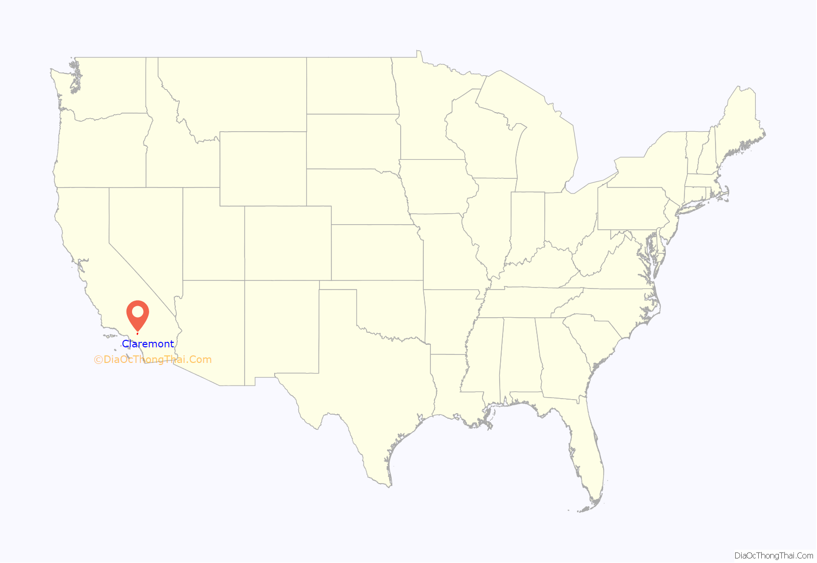
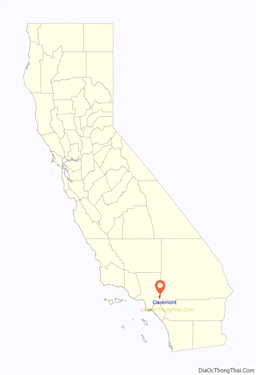
Claremont location map. Where is Claremont city?
History
Prior to the establishment of the city of Claremont, the area was frequented by the Serrano, Cahuilla, and Tongva for thousands of years. The Tongva established villages in the area as early as 7000 B.C. and thrived from the freshwater of what the Spanish would call the San Antonio Creek. One well-documented Tongva village, known as Torojoatngna, was located at a place called “Indian Hill” by early American settlers. The village was active until the nineteenth century, housing nearly 200 residents in 1870, yet was eventually abandoned after being ravaged by a smallpox epidemic by 1883.
The city of Claremont was first mapped out by developers in a land boom precipitated by the arrival of transcontinental railroads to Southern California. It was likely named after Claremont, New Hampshire. The early history of the city was closely tied to that of Pomona College, which moved there in 1889. In 1902, a town meeting vote established that east–west streets would be numbered and north–south streets named after colleges and universities. The city was incorporated in 1907.
The citrus groves and open space which once dominated the northern portion of the city have been replaced by residential developments of large homes. Construction of Stone Canyon Preserve, one of the final residential tract developments in the north of the city, commenced in 2003 as part of a complicated agreement between Pomona and the City of Claremont which resulted in the creation of the 1,740-acre (7.0 km) Wilderness Park. The foothill area also includes the Padua Hills Theatre (a historic site constructed in 1930) and the Claraboya residential area.
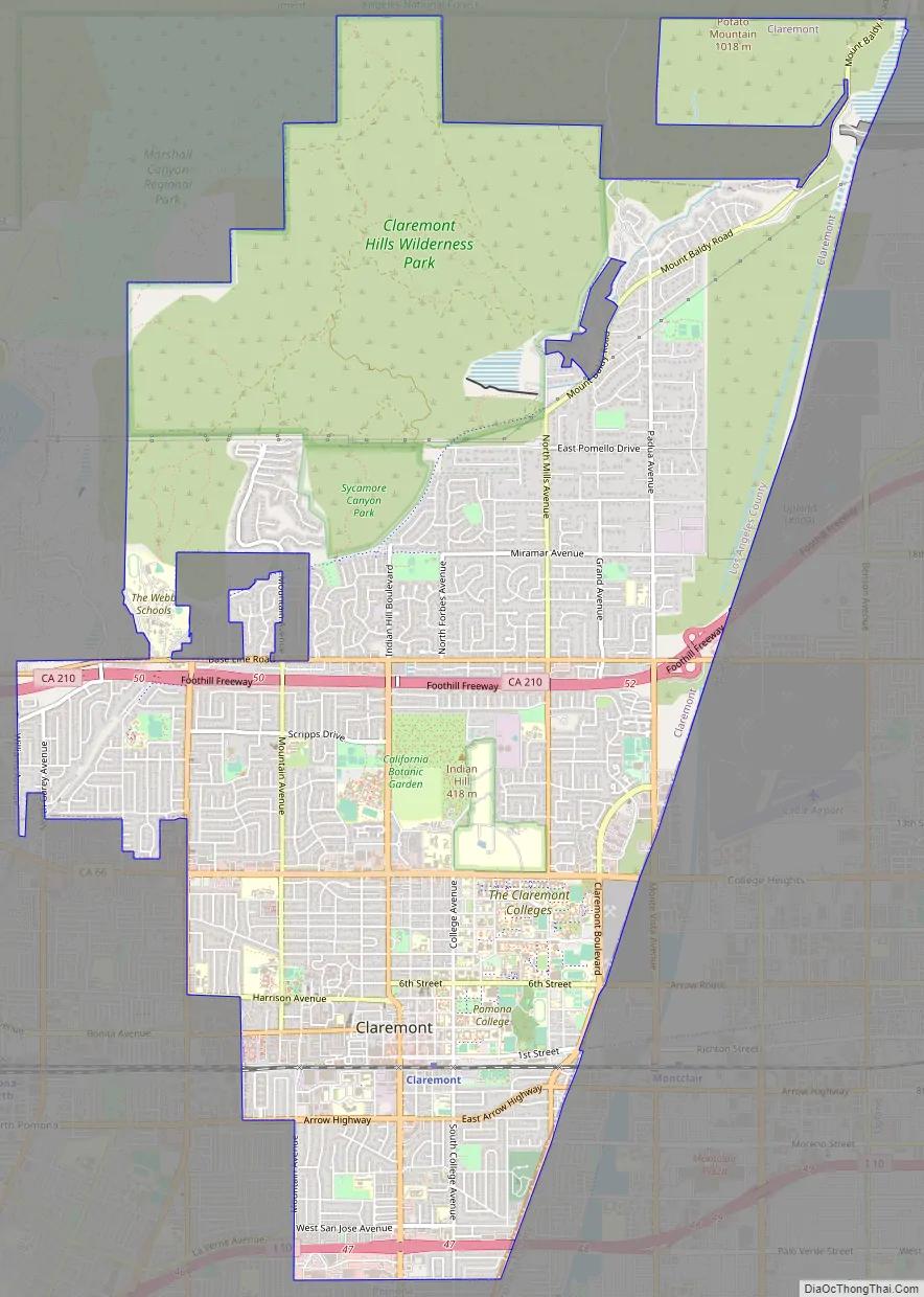
Claremont Road Map
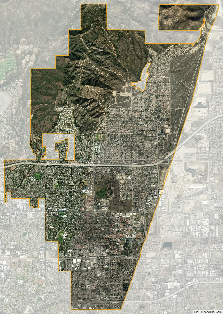
Claremont city Satellite Map
Geography
According to the United States Census Bureau, the city has a total area of 13.35 square miles (34.6 km), of which 13.3 square miles (34 km) is land and 0.05 square miles (0.13 km) (1.03%) is water. Claremont is located at the eastern end of Los Angeles County and borders the cities of Upland and Montclair in San Bernardino County, as well as the cities of Pomona and La Verne in Los Angeles County. It is geographically located in the Pomona Valley. Claremont is approximately 30 miles (48 km) east of downtown Los Angeles.
Climate
Claremont has a Mediterranean climate (Köppen climate classification Csa). In the summer months, temperatures may get very hot, sometimes rising above 100 °F (38 °C). In the autumn months, Claremont can experience the gusty “Santa Ana Winds”, which can bring fire danger to nearby foothill areas. In the winter months, most of the city’s annual rainfall occurs, which is typical around the Los Angeles metropolitan area. Snow is rare in Claremont, but can be viewed in the nearby San Gabriel Mountains in winter. In late spring, Claremont can receive many overcast days due to the strong onshore flow from the ocean, this is typically called “May Gray” or “June Gloom” in the region.
See also
Map of California State and its subdivision:- Alameda
- Alpine
- Amador
- Butte
- Calaveras
- Colusa
- Contra Costa
- Del Norte
- El Dorado
- Fresno
- Glenn
- Humboldt
- Imperial
- Inyo
- Kern
- Kings
- Lake
- Lassen
- Los Angeles
- Madera
- Marin
- Mariposa
- Mendocino
- Merced
- Modoc
- Mono
- Monterey
- Napa
- Nevada
- Orange
- Placer
- Plumas
- Riverside
- Sacramento
- San Benito
- San Bernardino
- San Diego
- San Francisco
- San Joaquin
- San Luis Obispo
- San Mateo
- Santa Barbara
- Santa Clara
- Santa Cruz
- Shasta
- Sierra
- Siskiyou
- Solano
- Sonoma
- Stanislaus
- Sutter
- Tehama
- Trinity
- Tulare
- Tuolumne
- Ventura
- Yolo
- Yuba
- Alabama
- Alaska
- Arizona
- Arkansas
- California
- Colorado
- Connecticut
- Delaware
- District of Columbia
- Florida
- Georgia
- Hawaii
- Idaho
- Illinois
- Indiana
- Iowa
- Kansas
- Kentucky
- Louisiana
- Maine
- Maryland
- Massachusetts
- Michigan
- Minnesota
- Mississippi
- Missouri
- Montana
- Nebraska
- Nevada
- New Hampshire
- New Jersey
- New Mexico
- New York
- North Carolina
- North Dakota
- Ohio
- Oklahoma
- Oregon
- Pennsylvania
- Rhode Island
- South Carolina
- South Dakota
- Tennessee
- Texas
- Utah
- Vermont
- Virginia
- Washington
- West Virginia
- Wisconsin
- Wyoming


