Dana Point (/ˌdeɪnə-/) is a city located in southern Orange County, California, United States. The population was 33,107 at the 2020 census. It has one of the few harbors along the Orange County coast, and with ready access via State Route 1, it is a popular local destination for surfing.
The city was named after the headland of Dana Point, which was in turn named after Richard Henry Dana, Jr., author of Two Years Before the Mast, which included a description of the area. Dana described the locale, including neighboring San Juan Capistrano, as “the only romantic spot on the coast”. This area is designated California Historical Landmark #189.
| Name: | Dana Point city |
|---|---|
| LSAD Code: | 25 |
| LSAD Description: | city (suffix) |
| State: | California |
| County: | Orange County |
| Incorporated: | January 1, 1989 |
| Elevation: | 144 ft (44 m) |
| Total Area: | 6.75 sq mi (17.49 km²) |
| Land Area: | 6.49 sq mi (16.80 km²) |
| Water Area: | 0.26 sq mi (0.68 km²) 77.96% |
| Total Population: | 33,107 |
| Population Density: | 5,102.81/sq mi (1,970.18/km²) |
| Area code: | 949 |
| FIPS code: | 0617946 |
| Website: | www.danapoint.org |
Online Interactive Map
Click on ![]() to view map in "full screen" mode.
to view map in "full screen" mode.
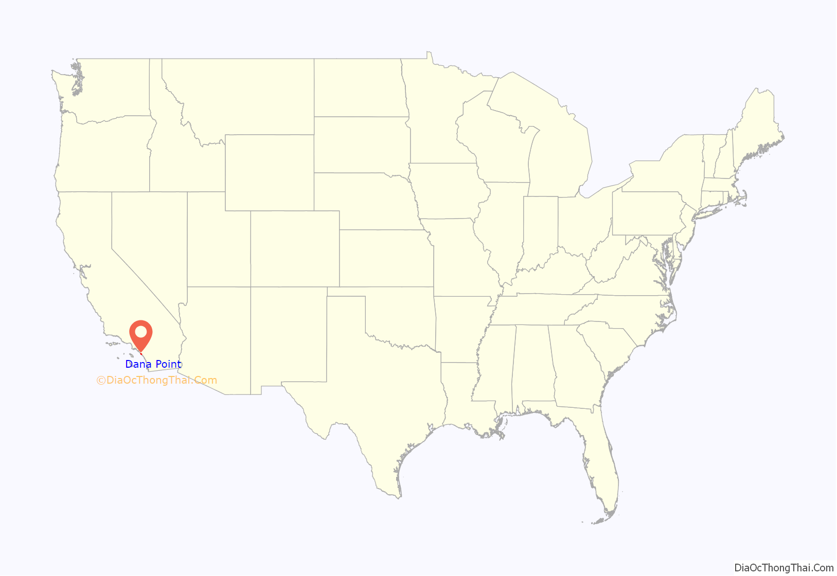
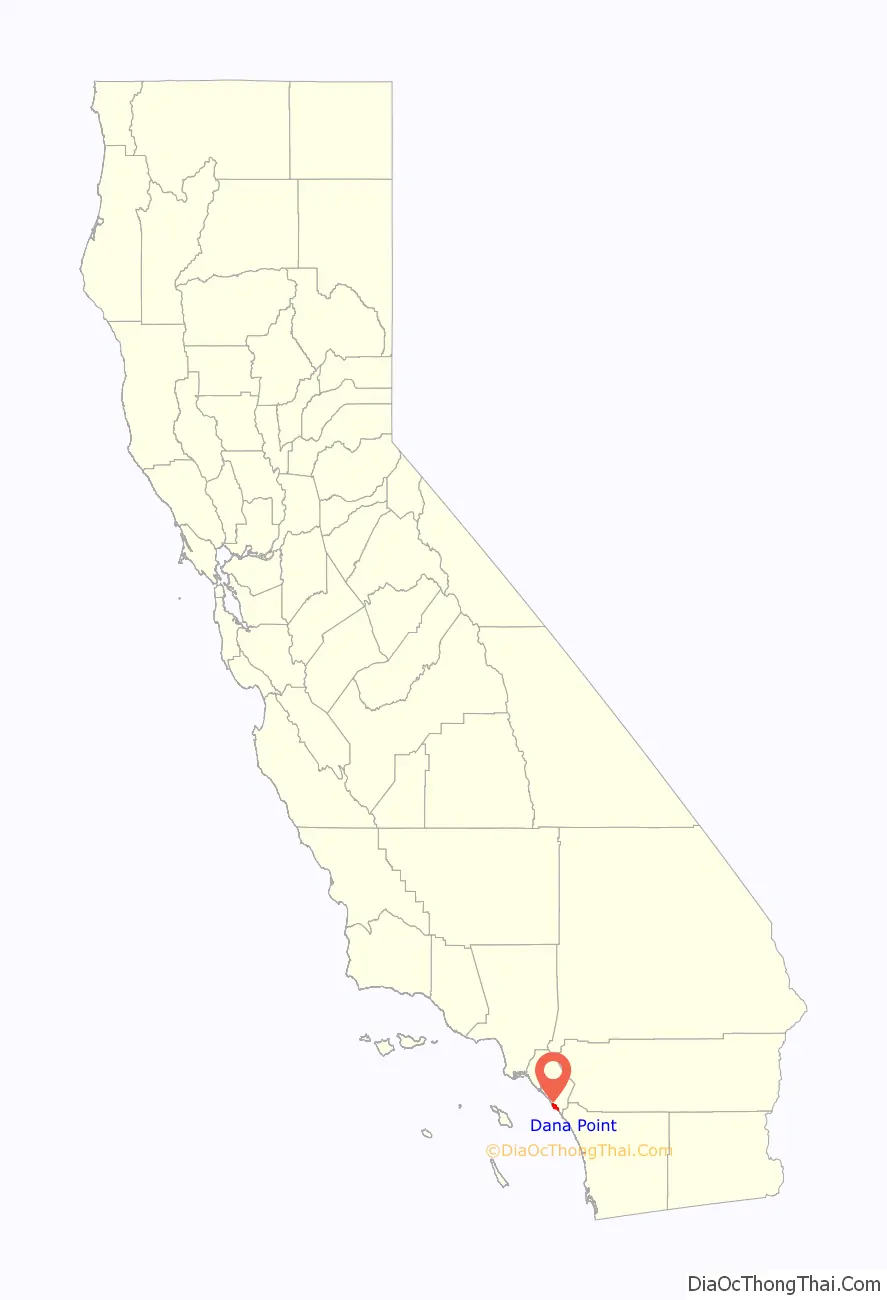
Dana Point location map. Where is Dana Point city?
History
Indigenous
The Acjachemen village site of Toovannga was located near the present-day site of Dana Point Harbor. The village was located near the mouth of the San Juan Creek. The people lived in villages of around 250 people and stewarded the land into a thriving ecosystem. Each village was politically independent and established ties with other villages through marriage. The area of Dana Point is located downstream from the mother village of Putuidem.
The arrival of European settlers in the area began with the Portolá expedition (1769-1770). Starting in 1776, people from the village of Ubange, located near Dana Point, were brought to Mission San Juan Capistrano for conversion to Christianity and to be exploited as labor to work the mission’s grounds. By 1778, dissatisfaction with the missions led to the formation of a revolt by tribal leader Cinquanto that was preemptively stopped by the Spanish.
Spanish era
Dana Point was a popular port for ships involved with the hide trade with nearby Mission San Juan Capistrano. Trading reached its peak in the 1830s and 1840s. In 1818, Argentine sailor Hippolyte de Bouchard anchored there while conducting his raid on the mission. Richard Henry Dana then visited the area in 1835 while serving aboard the sailing brig Pilgrim on her voyage along the California coastline.
American era
In 1923, Los Angeles Times publisher Harry Chandler and General M. H. Sherman, director of the Pacific Electric Railway Company, created a major real estate group to develop the Hollywood Hills. Sidney H. Woodruff, already a prominent Los Angeles homebuilder, was hired to lead the project.
In 1926, Woodruff, Chandler, and Sherman created the Dana Point Syndicate. They invited other investors, company presidents, movie producers, and real estate investors to join them in purchasing 1,388 acres (5.6 km) of land, some of which includes the “Headlands” of today. Promising tree-lined and paved streets, electricity, telephones, sidewalks, water mains, storm drains, sewers, and other amenities, Woodruff built 35 homes and a number of commercial buildings.
Most of these “Woodruff” houses are concentrated in the Dana Point historic core, also called Lantern Village (currently about 12,000 residents). The streets are named after different colored lanterns—Street of the Violet Lantern, Blue Lantern, etc.—because colored lanterns were used by ships 200 years ago to advertise their fares when in the Dana Point natural harbor. His crowning structure was to be the Dana Point Inn, a Mediterranean-like resort hotel on the cliffs overlooking the harbor. After a celebratory groundbreaking in 1930, a three-story foundation was poured and a 135-foot (41 m) shaft was dug for an elevator to transport hotel guests to and from the beach. The economic downturn of the Great Depression caused construction to halt, however. Although Woodruff continuously sought financial support through the years, this project was abandoned in 1939. Subsequently, he sold the remaining holdings of the Dana Point Syndicate. Thirty-four of the original Woodruff residences are still occupied.
Dana Point Harbor
The harbor, built in the 1960s and dedicated on July 31, 1971, is home to a marina, shops, and restaurants, and is a point of departure for the Catalina Express, a transportation service to and from the City of Avalon on Catalina Island. The entire harbor of Dana Point, including the Embarcadero Marina shops and restaurants, is set for complete demolition and redevelopment. The current vintage nautical style is being abandoned for a Tech Minimalist concept using metal roofs as well as Minimalist landscaping.
Although Richard Henry Dana, Jr., author of Two Years Before the Mast, described the anchorage as poor, it is now a developed harbor and had a replica of his ship, the Pilgrim. The Pilgrim was used as a classroom by the Ocean Institute until it sank in 2020.
Strand
The Strands at Headlands is a luxury housing development built on land that was originally part of the Chandler Family holdings. For decades the land facing the beach was home to the Dana Strand Beach and Tennis Club, a mobile home community that closed in the late 1980s. For years, access to the Strands beach was limited to hiking down a dirt trail where the mobile homes had stood. The Strands parcel included the actual headlands and bluff of Dana Point as well and was one of the last large coast properties available for development along the Orange County Coast. During the course of a ten-year approval process, the original high-density plan, which included a large multi-story hotel on the bluff top and hundreds of houses and multi-family units, was reduced in scope to just over 100 home sites. As part of negotiations with the California Coastal Commission, the developer agreed to turn the bluff into a nature preserve and build over $11 million worth of public improvements to provide easier access to Strands Beach. The improvements include stairs, restrooms, a beach-front sidewalk and a funicular to transport visitors from the parking lot to the beach. After extensive infrastructure construction, lots were offered for sale in the fall of 2006. Lots in the development are rectangular with modern houses commonly priced above $10,000,000. The development has provided much easier access to the beach below and has allowed surfers and other beach visitors to access the beach quickly and easily. Strands Homeowners, through a Mello-Roos assessment, pay for the upkeep of the beach improvements.
The community of Niguel Shores is subject to the eroding bluffs of the Strand.
Capistrano Beach
In 1928, a corporate entity of the American industrial giant Edward Doheny, who had built his fortune in oil production in Southern California and Mexico, purchased a number of lots in Capistrano Beach. Doheny’s son, Ned, formed a development company, the Capistrano Beach Company, which included his wife’s twin brothers, Clark and Warren Smith, and Luther Eldridge, a contractor, to build a community of Spanish style houses. According to Dana Point historians Baum and Burnes,* Eldridge favored two dominant characteristics in his homes, a typically Spanish roofline and the use of large ceiling beams in the main rooms of the houses. The roofline, covered with red ceramic tiles, incorporated a low-pitched gable, spreading out to one short and one long roof. The ceiling beams were decorated with stenciled artwork painted by artist Alex Meston. Eldridge was able to complete the original Doheny family house on the bluffs, four houses on the beach, and 18 other homes scattered throughout the area before tragedy struck the ambitious project.
Edward Doheny was preparing for his criminal trial for bribery in the Teapot Dome Scandal, and on February 16, 1929, Ned Doheny and Hugh Plunkett, his friend and secretary, who were to testify in the trial, were killed in a murder that still remains unsolved. In 1931, as a memorial to Ned, Petroleum Securities Company, Doheny’s family-owned business, made a gift of 41.4 acres (168,000 m) to the State of California, which is now Doheny State Beach. The unimproved Capistrano Beach properties passed back to Edward Doheny, and, upon his death in 1935, to his wife and heirs. By 1944, all of the properties had been sold to private parties. The Doheny family also funded the building of what was then called St. Edward’s Chapel in Capistrano Beach. The chapel soon grew, received canonical status as a parish, and moved to its current bluff-top location in Dana Point, overlooking Doheny State Beach.
In October 2022, the California Coastal Commission approved a desalination plant on Doheny State Beach capable of producing 5 to 15 million gallons of fresh water per day.
Surfing
Richard Henry Dana (the author of “Two Years Before the Mast”) considered the high bluffs and sheltered coves of this area of Southern California to be the most beautiful spot on the California coast. Pioneering surfers agreed as they surfed the many beach breaks along the coast. Dana Point had a notable surfing history, and was home to many of the first companies that produced products for surfing. Hobie Alter opened the world’s first retail surf shop in Dana Point in 1954. Many surf publications such as the Surfer’s Journal and Surfer Magazine were formed and headquartered in Dana Point. Bruce Brown produced the iconic surfer film Endless Summer in Dana Point.
“Killer Dana” was a legendary surf break off Dana Point. The surf break was notorious because it came out of deep water and broke close to the rocks that lined the beach. The Killer Dana wave was destroyed when the Dana Point Harbor was built in 1966. A breakwater now cuts right through the heart of the once epic surf spot. In 1997, the surf group The Chantays recorded an instrumental track named “Killer Dana”.
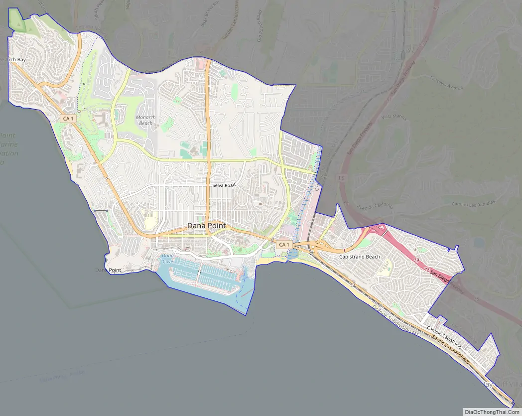
Dana Point Road Map
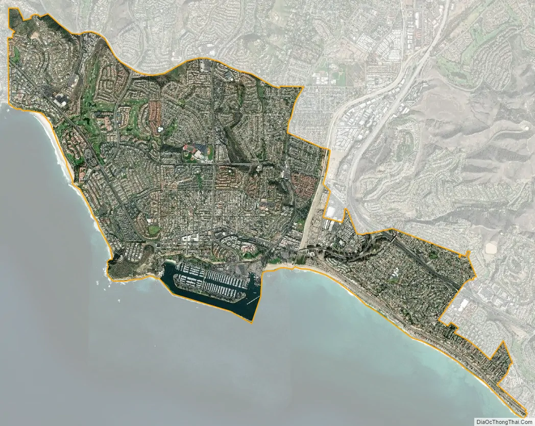
Dana Point city Satellite Map
Geography
According to the United States Census Bureau, the city has a total area of 29.5 square miles (76 km). 6.5 square miles (17 km) of it is land and 23.0 square miles (60 km) of it (77.96%) is water.
The Dana Point headlands are a prominent feature in Orange County geography and after years of controversy, are currently being developed as a 118-house gated community, however 68 acres (280,000 m) of the site is open to the public and features a nature center and walking trails exhibiting “lost” plants of the Southern California coast. Views on a clear day extend to Catalina Island and La Jolla in San Diego County.
The city is located 59 miles southeast of Los Angeles, and 65 miles northwest of San Diego. Dana Point is bordered by San Clemente to the southeast, San Juan Capistrano to the northeast, Laguna Beach to the northwest, and Laguna Niguel to the north.
Climate
Dana Point enjoys a mild climate with temperatures that tend to average around the 70s. The warmest month of the year is August with an average maximum temperature of 79 °F (26 °C). The coldest month is December with an average maximum temperature of 65 degrees Fahrenheit. Frost is extremely rare, allowing for a year-round growing season. Annual rainfall (with almost all of it falling between November and March) is about 12 inches but is highly variable from year to year.
See also
Map of California State and its subdivision:- Alameda
- Alpine
- Amador
- Butte
- Calaveras
- Colusa
- Contra Costa
- Del Norte
- El Dorado
- Fresno
- Glenn
- Humboldt
- Imperial
- Inyo
- Kern
- Kings
- Lake
- Lassen
- Los Angeles
- Madera
- Marin
- Mariposa
- Mendocino
- Merced
- Modoc
- Mono
- Monterey
- Napa
- Nevada
- Orange
- Placer
- Plumas
- Riverside
- Sacramento
- San Benito
- San Bernardino
- San Diego
- San Francisco
- San Joaquin
- San Luis Obispo
- San Mateo
- Santa Barbara
- Santa Clara
- Santa Cruz
- Shasta
- Sierra
- Siskiyou
- Solano
- Sonoma
- Stanislaus
- Sutter
- Tehama
- Trinity
- Tulare
- Tuolumne
- Ventura
- Yolo
- Yuba
- Alabama
- Alaska
- Arizona
- Arkansas
- California
- Colorado
- Connecticut
- Delaware
- District of Columbia
- Florida
- Georgia
- Hawaii
- Idaho
- Illinois
- Indiana
- Iowa
- Kansas
- Kentucky
- Louisiana
- Maine
- Maryland
- Massachusetts
- Michigan
- Minnesota
- Mississippi
- Missouri
- Montana
- Nebraska
- Nevada
- New Hampshire
- New Jersey
- New Mexico
- New York
- North Carolina
- North Dakota
- Ohio
- Oklahoma
- Oregon
- Pennsylvania
- Rhode Island
- South Carolina
- South Dakota
- Tennessee
- Texas
- Utah
- Vermont
- Virginia
- Washington
- West Virginia
- Wisconsin
- Wyoming


