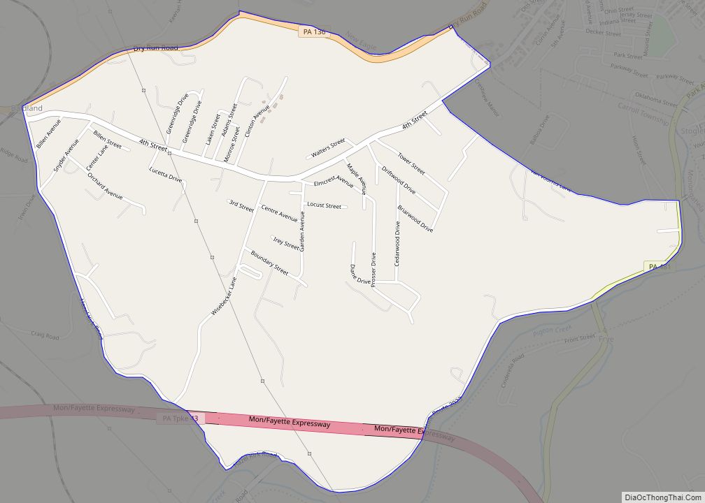
Roscoe is a borough in Washington County, Pennsylvania, United States. The population was 716 at the 2020 census.
| Name: | Roscoe borough |
|---|---|
| LSAD Code: | 21 |
| LSAD Description: | borough (suffix) |
| State: | Pennsylvania |
| County: | Washington County |
| Total Area: | 0.25 sq mi (0.64 km²) |
| Land Area: | 0.18 sq mi (0.47 km²) |
| Water Area: | 0.06 sq mi (0.17 km²) |
| Total Population: | 720 |
| Population Density: | 3,956.04/sq mi (1,528.02/km²) |
| Area code: | 724 |
| FIPS code: | 4266016 |
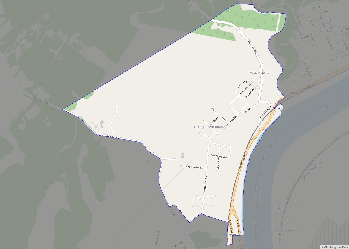
Online Interactive Map
Click on ![]() to view map in "full screen" mode.
to view map in "full screen" mode.
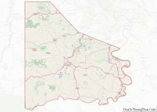
Roscoe location map. Where is Roscoe borough?


History
Roscoe became the home for many eastern European immigrants who came to the area to work in nearby coal mines. Slovaks, Poles, Serbs, Croatians, Italians, Hungarians, and Rusyns are all represented in census records of the area from 1880 onward.
The Allenport & Roscoe Street Railway was formed in 1903 and was purchased by Pittsburgh Railways to form part of their interurban line to Pittsburgh in 1906. The 2.4 miles (3.9 km) extension to Roscoe was completed on June 20, 1910. The line was closed in 1953.
The town was originally named Lucyville as early as 1860; however, the community changed its name to Roscoe in honor of the maiden name of a local resident, Mrs. Joseph Underwood,
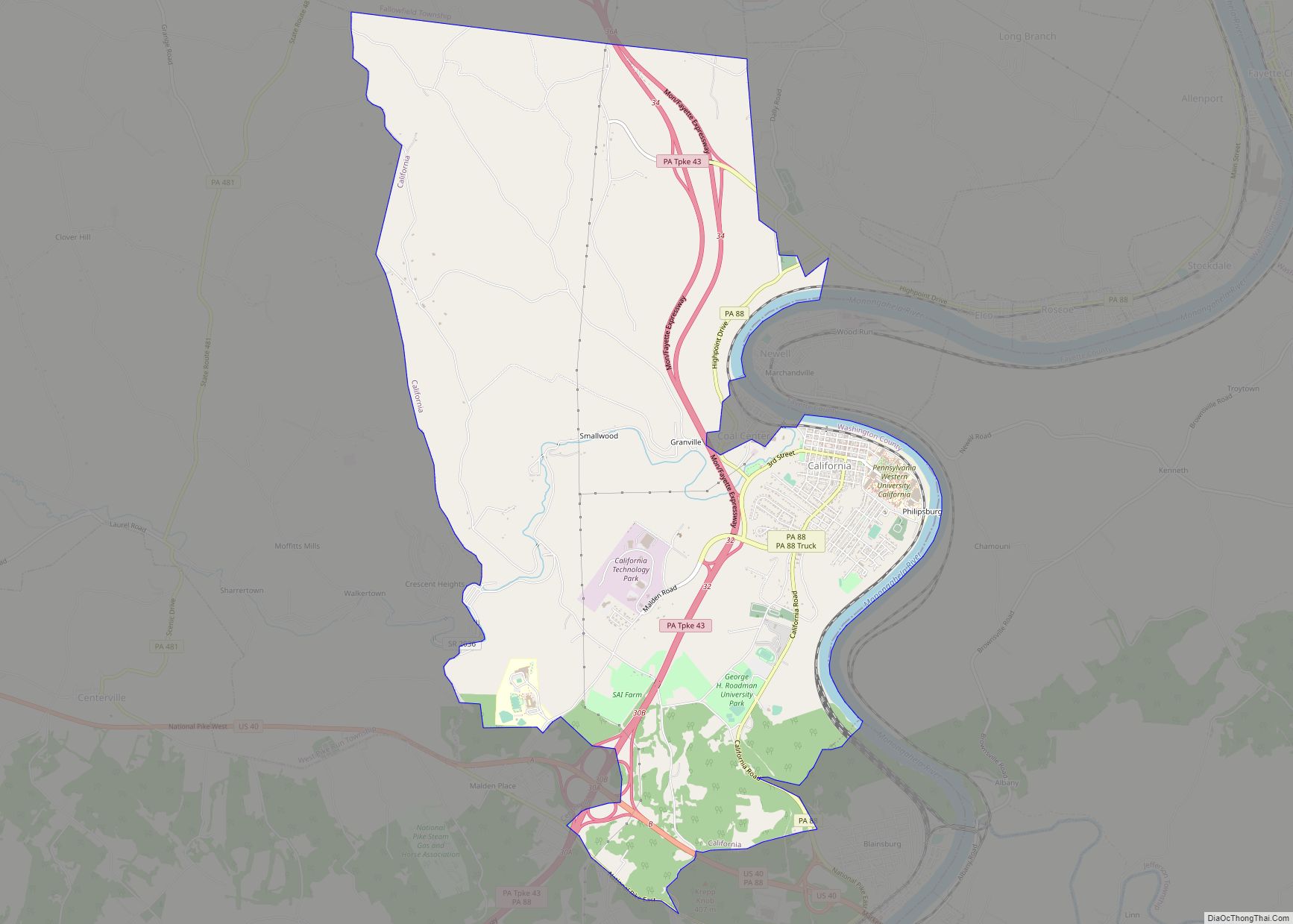
Roscoe Road Map

Roscoe city Satellite Map

Geography
Roscoe is located at 40°4′43″N 79°51′55″W / 40.07861°N 79.86528°W / 40.07861; -79.86528 (40.078513, -79.865225).
According to the United States Census Bureau, the borough has a total area of 0.2 square miles (0.5 km), of which 0.2 square miles (0.5 km) is land and 0.04 square miles (0.10 km) (16.67%) is water.
See also
Map of Pennsylvania State and its subdivision:- Adams
- Allegheny
- Armstrong
- Beaver
- Bedford
- Berks
- Blair
- Bradford
- Bucks
- Butler
- Cambria
- Cameron
- Carbon
- Centre
- Chester
- Clarion
- Clearfield
- Clinton
- Columbia
- Crawford
- Cumberland
- Dauphin
- Delaware
- Elk
- Erie
- Fayette
- Forest
- Franklin
- Fulton
- Greene
- Huntingdon
- Indiana
- Jefferson
- Juniata
- Lackawanna
- Lancaster
- Lawrence
- Lebanon
- Lehigh
- Luzerne
- Lycoming
- Mc Kean
- Mercer
- Mifflin
- Monroe
- Montgomery
- Montour
- Northampton
- Northumberland
- Perry
- Philadelphia
- Pike
- Potter
- Schuylkill
- Snyder
- Somerset
- Sullivan
- Susquehanna
- Tioga
- Union
- Venango
- Warren
- Washington
- Wayne
- Westmoreland
- Wyoming
- York
- Alabama
- Alaska
- Arizona
- Arkansas
- California
- Colorado
- Connecticut
- Delaware
- District of Columbia
- Florida
- Georgia
- Hawaii
- Idaho
- Illinois
- Indiana
- Iowa
- Kansas
- Kentucky
- Louisiana
- Maine
- Maryland
- Massachusetts
- Michigan
- Minnesota
- Mississippi
- Missouri
- Montana
- Nebraska
- Nevada
- New Hampshire
- New Jersey
- New Mexico
- New York
- North Carolina
- North Dakota
- Ohio
- Oklahoma
- Oregon
- Pennsylvania
- Rhode Island
- South Carolina
- South Dakota
- Tennessee
- Texas
- Utah
- Vermont
- Virginia
- Washington
- West Virginia
- Wisconsin
- Wyoming