South Park Township is a township in the southern part of Allegheny County, Pennsylvania, United States, near Pittsburgh. The population was 13,416 at the 2010 census.
A large portion of the township consists of a county park of the same name.
| Name: | South Park Township CDP |
|---|---|
| LSAD Code: | 57 |
| LSAD Description: | CDP (suffix) |
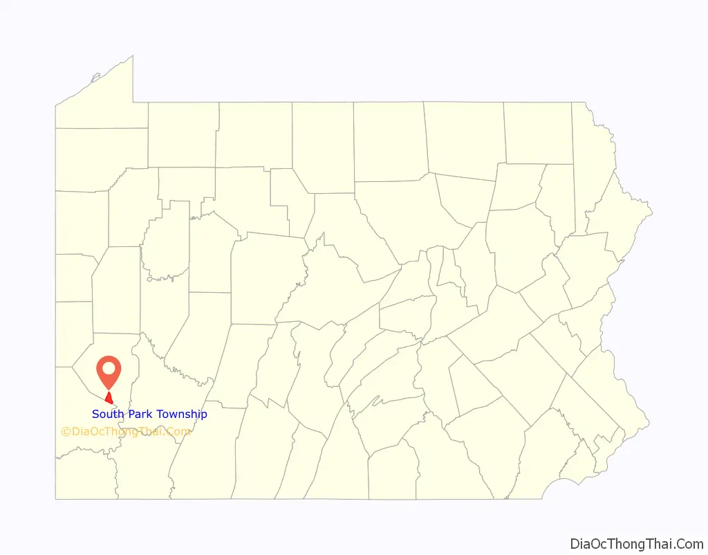
| State: | Pennsylvania |
| County: | Allegheny County |
| Total Area: | 9.27 sq mi (24.01 km²) |
| Land Area: | 9.27 sq mi (24.01 km²) |
| Water Area: | 0.00 sq mi (0.00 km²) |
| Total Population: | 13,416 |
| Population Density: | 1,443.26/sq mi (557.23/km²) |
| ZIP code: | 15129 |
| FIPS code: | 4272403 |
Online Interactive Map
Click on ![]() to view map in "full screen" mode.
to view map in "full screen" mode.
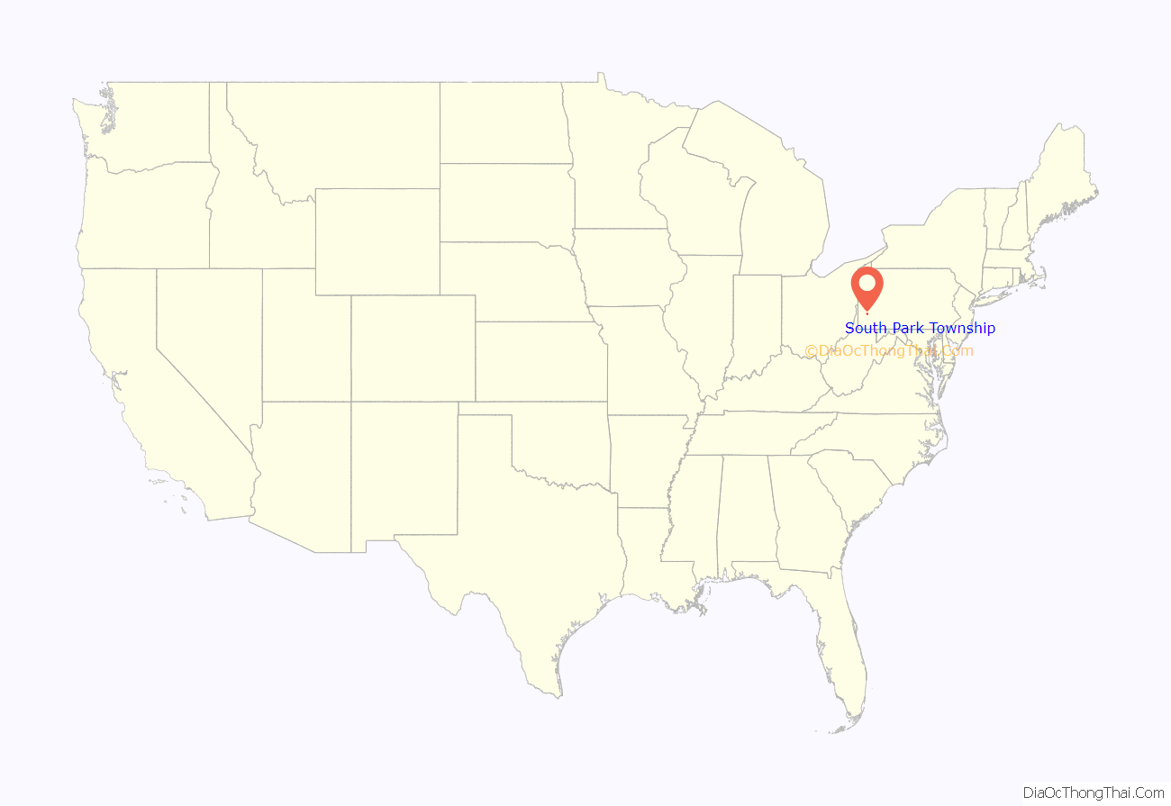
South Park Township location map. Where is South Park Township CDP?
History
Composed of portions of St. Clair and Jefferson townships in 1845, South Park was originally called Snowden Township, named after John M. Snowden, a prominent businessman, politician and former Pittsburgh mayor, who had died earlier that year. In the 1930s, Allegheny County acquired several large parcels of farm land mostly within Snowden Township and created a regional recreational area named South Park. The huge success of South Park, and the fact the facility occupies roughly one-third of the community’s total area, eventually prompted a 1966 referendum in which the township was renamed.
The area in and around South Park Township was settled in the mid-18th century. It is the location of the Oliver Miller Homestead where in 1794, the first shots of the Whiskey Rebellion were fired. A log house was originally built on the site in 1772; it was replaced by a stone structure around 1830, which is open for public tours.
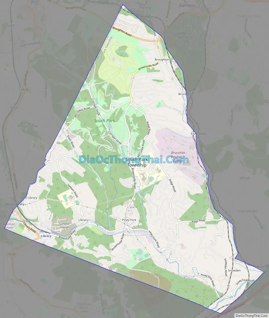
South Park Township Road Map
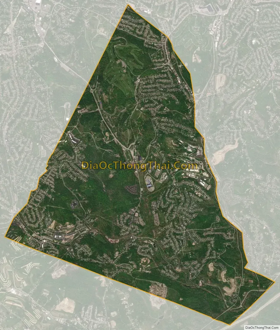
South Park Township city Satellite Map
Geography
South Park is located at 40°17′54″N 80°0′7″W / 40.29833°N 80.00194°W / 40.29833; -80.00194 (40.298382, -80.002097). South Park’s zip code is 15129. According to the United States Census Bureau, the township has a total area of 9.2 square miles (23.8 km), all land. A negligible area is covered by streams and creeks, most notably Peters Creek. South Park, a 1,999-acre (809 ha) recreational area operated by Allegheny County, is located mostly within the boundaries of South Park Township, although a portion is located in adjacent Bethel Park.
The township is on the Allegheny Plateau, near where the Allegheny River from the northeast and Monongahela River from the southeast join to form the Ohio River in Pittsburgh. South Park township’s topography is quite hilly. The hilltops are somewhat “carved” out by the streams in the area.
Surrounding neighborhoods
South Park Township has five borders, including Baldwin to the north, Pleasant Hills and Jefferson Hills to the east, Union Township (in Washington County) to the south, and Bethel Park to the west.
Climate
South Park falls in the humid continental zone (Köppen Dfa/Dfb). It features four distinct seasons, with precipitation somewhat evenly spread throughout the year. Summers are hot and humid (with occasional heat waves), while winters are cold and snowy. Fall and spring are mild to warm.
The warmest month of the year in South Park, as in most of the northern hemisphere, is July. The average high temperature is 81 °F (27.2 °C), with overnight low temperatures averaging 57 °F (13.9 °C). July is often humid, resulting in a considerable heat index. The coldest month of the year is January, when the average high temperature is 30 °F (−1.1 °C). Overnight low temperatures average 18 °F (−7.8 °C). The highest temperature ever recorded in South Park was 101 °F (38.3 °C), on July 16, 1988, and the coldest temperature ever recorded was −23 °F (−30.6 °C), on January 19, 1994.
Due to its position on the windward side of the Allegheny Mountains, South Park Township receives heavier precipitation than cities located farther to the west, and many days are subject to overcast skies, with 153 days of the year with some precipitation and only 2024 sunshine hours per year. Precipitation is greatest in May, due to frequent thunderstorms and more organized low pressure systems which track up the eastern coast of the United States. On average, 4.04 inches (103 mm) of precipitation falls during this month. The driest month of the year is October, when 2.35 inches (60 mm). Annual precipitation is around 37.9 inches (963 mm), while annual snowfall is 40.3 inches (102 cm).
South Park has been hit with extreme weather. The Blizzard of 1993 dumped 23 inches (58 cm) of snow in under 24 hours. A blizzard in February 2010 dumped nearly two feet of snow in less than 24 hours, and nearly 4 feet in the following week. In September 2004, the remnants of Hurricane Ivan brought gusty winds and dropped nearly 6 inches (150 mm) of rain in 12 hours.
Neighborhoods
South Park can be broken down into the six different neighborhoods. The neighborhoods are grouped primarily by the small towns throughout the township and the time era which the plans of homes were built.
Broughton borders Curry and extends further down Brownsville Road. Most of Broughton is residential with a few businesses, gas stations, and eateries along Brownsville Road. Legendary Irwin Basketball player (and all-time leading scorer) Lloyd Simpson resided in Broughton.
On the northern side, the area is known as Curry. Curry is a mix of residential homes and a small commercial area, and Curry extends from the northeastern corner to the northwestern corner and down Brownsville Road. The former Broughton Elementary School was located here.
Library, formally known as Loafer’s Hollow, is a large neighborhood of South Park. It has a mix of residential, commerce, and industrial areas. Library is South Park Township’s “Downtown”. It has many businesses along Route 88. Along Piney Fork Road, there are also many shops and a few industrial complexes. There are many large plans of houses throughout Library also. South Park Middle School is also located here. Library is served by the Library station on the Port Authority of Allegheny County’s light rail network’s Blue Line Library branch, to be renamed the Silver Line on March 15, 2020.
Piney Fork is in the south-central part of South Park. It is a large residential area with a few small stores and restaurants.
Snowden is a neighborhood in the southeastern corner of the township. It is a rural area with some homes and farms. Snowden was once a small mining community, but was absorbed into South Park.
See also
Map of Pennsylvania State and its subdivision:- Adams
- Allegheny
- Armstrong
- Beaver
- Bedford
- Berks
- Blair
- Bradford
- Bucks
- Butler
- Cambria
- Cameron
- Carbon
- Centre
- Chester
- Clarion
- Clearfield
- Clinton
- Columbia
- Crawford
- Cumberland
- Dauphin
- Delaware
- Elk
- Erie
- Fayette
- Forest
- Franklin
- Fulton
- Greene
- Huntingdon
- Indiana
- Jefferson
- Juniata
- Lackawanna
- Lancaster
- Lawrence
- Lebanon
- Lehigh
- Luzerne
- Lycoming
- Mc Kean
- Mercer
- Mifflin
- Monroe
- Montgomery
- Montour
- Northampton
- Northumberland
- Perry
- Philadelphia
- Pike
- Potter
- Schuylkill
- Snyder
- Somerset
- Sullivan
- Susquehanna
- Tioga
- Union
- Venango
- Warren
- Washington
- Wayne
- Westmoreland
- Wyoming
- York
- Alabama
- Alaska
- Arizona
- Arkansas
- California
- Colorado
- Connecticut
- Delaware
- District of Columbia
- Florida
- Georgia
- Hawaii
- Idaho
- Illinois
- Indiana
- Iowa
- Kansas
- Kentucky
- Louisiana
- Maine
- Maryland
- Massachusetts
- Michigan
- Minnesota
- Mississippi
- Missouri
- Montana
- Nebraska
- Nevada
- New Hampshire
- New Jersey
- New Mexico
- New York
- North Carolina
- North Dakota
- Ohio
- Oklahoma
- Oregon
- Pennsylvania
- Rhode Island
- South Carolina
- South Dakota
- Tennessee
- Texas
- Utah
- Vermont
- Virginia
- Washington
- West Virginia
- Wisconsin
- Wyoming


