Greensboro is a borough in Greene County, Pennsylvania, United States. The population was 267 at the 2020 census, up from 260 at the 2010 census.
| Name: | Greensboro borough |
|---|---|
| LSAD Code: | 21 |
| LSAD Description: | borough (suffix) |
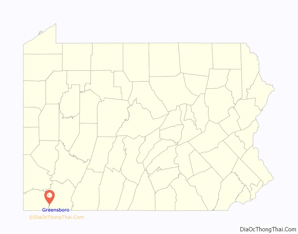
| State: | Pennsylvania |
| County: | Greene County |
| Elevation: | 800 ft (200 m) |
| Total Area: | 0.15 sq mi (0.38 km²) |
| Land Area: | 0.11 sq mi (0.28 km²) |
| Water Area: | 0.04 sq mi (0.10 km²) |
| Total Population: | 264 |
| Population Density: | 2,444.44/sq mi (941.51/km²) |
| Area code: | 724 |
| FIPS code: | 4231192 |
| Website: | www.greensboropa.com |
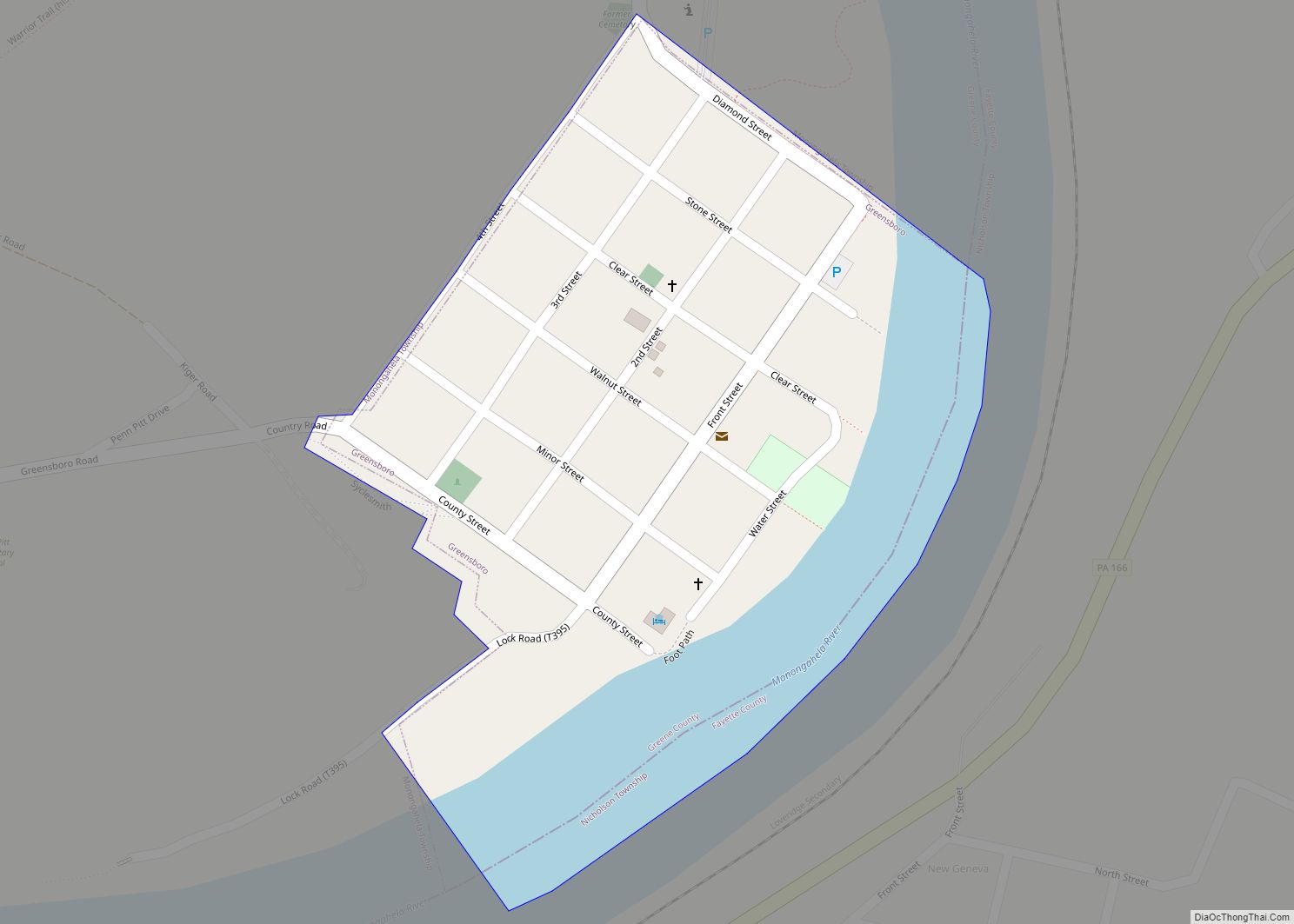
Online Interactive Map
Click on ![]() to view map in "full screen" mode.
to view map in "full screen" mode.
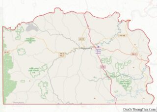
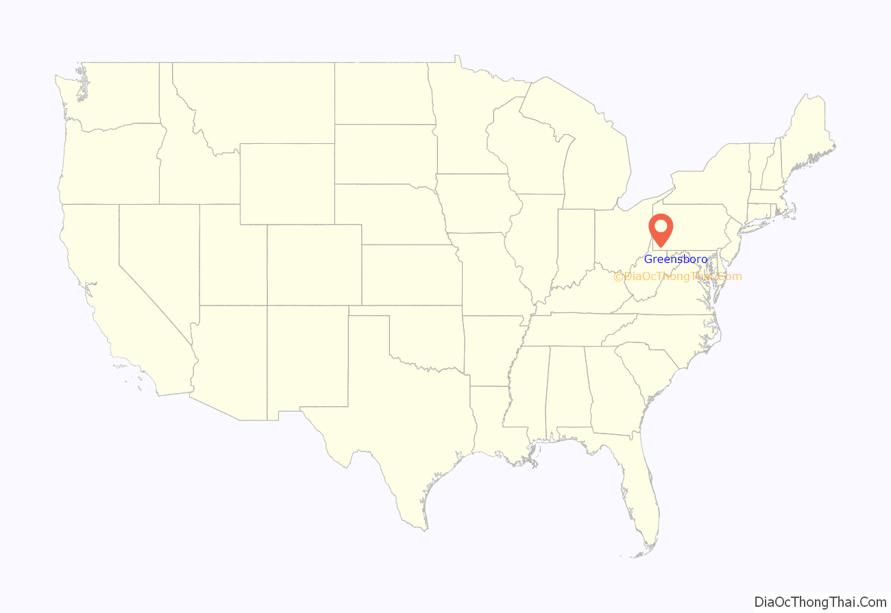
Greensboro location map. Where is Greensboro borough?
History
The beginning of settlement
Like much of the region, Greensboro can trace its roots back to Native American settlement, to the Mingo tribes of the Northern Iroquois. What was to later become Greensboro was first known to the Mingo as “Delight”, so named in recognition of the rich farmland that stretched along the banks of the Monongahela River. As early as 1752, settlers from the east and south began to stake their claims in the lands along the Monongahela. The first white settler of Delight was explorer-trader John Badolet, who was a close friend of John Minor. Minor was the leader of the first group to settle in the area presently known as Mapletown, to the northwest of Greensboro in Monongahela Township.
In the early 1780s, Elias Stone bought Delight and divided it into blocks and streets; these still carry their original names. On February 9, 1790, Stone’s growing village was named “Greensburgh” (later changed to “Greensboro”) in honor of the Revolutionary War hero Nathanael Greene, for whom Greene County was also named when it was formed from Washington County in 1796. Due to its advantageous geographic location along the river, it quickly became an early trading center for settlers and travelers heading north to Pittsburgh and to points West.
Albert Gallatin, a partner in Albert Gallatin & Company and later the Secretary of the Treasury under Presidents Thomas Jefferson and James Madison, purchased lots in Greensburgh in 1795. He also purchased a great deal of land in Fayette County, including what was to become later the town of New Geneva, directly across the river from Greensburgh. On a trip to Washington, D.C., Gallatin met a group of German glassblowers who were heading to Kentucky to form their own company. He urged them to consider settling in Greensburgh instead of Kentucky. With Gallatin’s assistance, the group settled in nearby New Geneva and operated the New Geneva Glass Works there until about 1805. Around that time, Gallatin was appointed the Secretary of the Treasury and sold his interest in the glassworks to his partners. The remaining partners moved the operation across the river to the northern section of Greensburgh, which consequently took on the name of Glassworks.
Early development
Glassmaking was the primary industry for many Monongahela River towns, including the city of Pittsburgh as well as small towns such as New Geneva and Greensboro, for several decades preceding the Civil War. The late 18th-early 19th century New Geneva/Greensboro glassworks proved that quality glass, natural resources, and transportation networks could be effectively harnessed. After the Civil War, the manufacture of stoneware became Greensboro’s leading industry, in addition to a prosperous clay tile manufacturer who specialized in roofing tiles. The mid 19th-century Greensboro stoneware potteries were among the most productive in the eastern United States. Talented artisans and craftsmen, along with the excellent nearby clay banks produced a distinctive blue-gray stoneware which had a large market. Due to its location at the head of the slack waters of the Monongahela, Greensboro’s influence as a commercial and manufacturing center expanded far beyond its small boundaries.
By the 1850s, the slack water system of locks and dams had been developed by the Monongahela Navigation Company (later acquired by the Army Corps of Engineers), allowing for year-round travel from Pittsburgh to the Greensboro area. This permitted Greensboro to become a shipping point not only for southern Greene County but for parts of what is now northern West Virginia as well. Its growing industrial, commercial, and transportation significance in the mid-19th century helped transform the town into a social and cultural center. In the 1880s, Greensboro essentially lost the pottery and clay tile market due to more efficient producers, and with the extension of slack water transportation to Morgantown became a more localized port.
During this period, many of the present churches in the community were established, with the Greensburgh Lutheran Church forming first. Other churches soon followed, such as the Presbyterians, Baptists, Methodists, and eventually, Roman Catholics and Eastern Orthodox. As was the tradition for early churches, particularly Protestants, most of these groups began meeting for worship in a member’s home, or during fair weather outside under large tents, with “circuit riders” as pastors until formal church structures could be built and an established clergy formed.
The industrial era and today
Around the start of the 20th century came industrialization, and Western Pennsylvania’s role was vital in the transformation of the national economy. A part of the Klondike coal seam, which extends through most of eastern Greene County and western Fayette County, the Greensboro area was rich in the mineral that made the region famous around the world. Greensboro, being a community already established with the conveniences, commerce and trade, suddenly found itself as a growing cultural and economic hub for many growing “coal patch towns” sprouting up in the area during the area Coal Rush.
Coal became King, and with Western Pennsylvania as his capital, it was only logical that Greensboro became part of this movement. Indeed, the Penn-Pitt neighborhood was originally company housing for miners, as were the nearby Seventh Pool and Poland Mines areas, and countless others, many of which are lost to history today. Thousands of immigrants from Eastern and Southern Europe flooded into the region and brought with them new customs, traditions, and culture.
Coal also became Ruler. History has shown that any growth industry using thousands of underskilled, undereducated immigrant workers provides fertile ground for the lust of greed and opportunism. Many mines and their owners sought to capitalize on this and found ways to maximize their profits. As such, many workers found themselves “selling their soul to the company store”, earning meager pay for a dangerous day’s wage, only to be spent on company goods and rent in the patch towns created by these very companies, effectively making these workers willful individuals of “wage slavery”. During this period the formation of unions such as the UMWA became more prevalent and necessary to represent the workers. Through the growth of the UMWA and events such as the “Red Neck Revolution of 1921” an era of wage slavery began to end.
At one point, the Greensboro area was famous for the Robena mine, known as the largest mine in the world at the peak of its production in 1946. Robena also became famous for a more tragic reason: in December 1962 37 miners died in an explosion at Robena No. 3, illustrating how precarious this work truly was.
Coal defined the region and the lives of those who inhabited it, and made not only Greensboro and the Monongahela Valley prosperous, but the nation as well. Yet this period was not to last, and as the coal seams became tapped out and the processes outdated and replaced with modern mechanical technology, communities like Penn-Pitt and Poland Mines began to fade as their reason for existence ceased.
While coal (followed by healthcare) currently remains the backbone for much of the economy of Greene County, Greensboro and other communities have been migrating away from such dependency and see benefits in non-industrial sources of employment in sectors such as ecotourism, agritourism, and community-supported agriculture (CSAs), as well as fishing, hunting, hiking and boating.
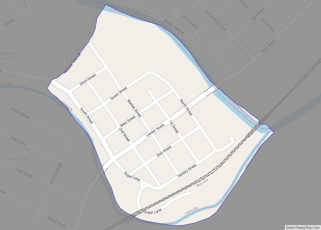
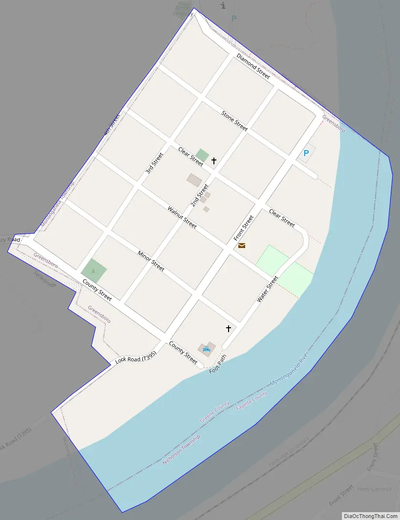
Greensboro Road Map
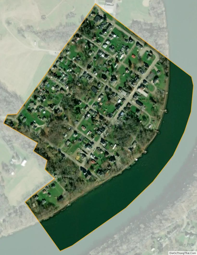
Greensboro city Satellite Map
Geography
Greensboro is located in southeastern Greene County at 39°47′34″N 79°54′44″W / 39.79278°N 79.91222°W / 39.79278; -79.91222 (39.792911, -79.912087). It is situated on the west bank of the Monongahela River, opposite New Geneva and the mouth of George’s Creek. It is bordered by Monongahela Township in Greene County to the north and west, and by Nicholson Township in Fayette County to the south and east, across the Monongahela. The county and township border follows the center of the river. The closest road bridges over the river are the Masontown Bridge on Pennsylvania Route 21, 8 miles (13 km) north of Greensboro by road, and the Albert Gallatin Memorial Bridge on Pennsylvania Route 88 at Point Marion, 6 miles (10 km) south of Greensboro.
According to the United States Census Bureau, the borough has a total area of 0.15 square miles (0.38 km), of which 0.11 square miles (0.28 km) are land and 0.04 square miles (0.10 km), or 26.06%, are water.
See also
Map of Pennsylvania State and its subdivision:- Adams
- Allegheny
- Armstrong
- Beaver
- Bedford
- Berks
- Blair
- Bradford
- Bucks
- Butler
- Cambria
- Cameron
- Carbon
- Centre
- Chester
- Clarion
- Clearfield
- Clinton
- Columbia
- Crawford
- Cumberland
- Dauphin
- Delaware
- Elk
- Erie
- Fayette
- Forest
- Franklin
- Fulton
- Greene
- Huntingdon
- Indiana
- Jefferson
- Juniata
- Lackawanna
- Lancaster
- Lawrence
- Lebanon
- Lehigh
- Luzerne
- Lycoming
- Mc Kean
- Mercer
- Mifflin
- Monroe
- Montgomery
- Montour
- Northampton
- Northumberland
- Perry
- Philadelphia
- Pike
- Potter
- Schuylkill
- Snyder
- Somerset
- Sullivan
- Susquehanna
- Tioga
- Union
- Venango
- Warren
- Washington
- Wayne
- Westmoreland
- Wyoming
- York
- Alabama
- Alaska
- Arizona
- Arkansas
- California
- Colorado
- Connecticut
- Delaware
- District of Columbia
- Florida
- Georgia
- Hawaii
- Idaho
- Illinois
- Indiana
- Iowa
- Kansas
- Kentucky
- Louisiana
- Maine
- Maryland
- Massachusetts
- Michigan
- Minnesota
- Mississippi
- Missouri
- Montana
- Nebraska
- Nevada
- New Hampshire
- New Jersey
- New Mexico
- New York
- North Carolina
- North Dakota
- Ohio
- Oklahoma
- Oregon
- Pennsylvania
- Rhode Island
- South Carolina
- South Dakota
- Tennessee
- Texas
- Utah
- Vermont
- Virginia
- Washington
- West Virginia
- Wisconsin
- Wyoming