Monongahela, referred to locally as Mon City, is a third class city in Washington County, Pennsylvania, United States. The population was 4,149 at the 2020 census. It is part of the Pittsburgh metropolitan area, about 17 miles (27 km) south of Pittsburgh proper.
The city of Monongahela sits at a location where several locally important Pennsylvania state routes meet: a concurrency between Pennsylvania routes 88, 136, and 837 makes up most of the length of the city’s Main Street, and the city’s Park Avenue carries Pennsylvania route 481 to its northern terminus at Main Street.
Monongahela is one of just two cities in Washington County, and is the second smallest city in Pennsylvania (after Parker). The town is served by the Ringgold School District.
| Name: | Monongahela city |
|---|---|
| LSAD Code: | 25 |
| LSAD Description: | city (suffix) |
| State: | Pennsylvania |
| County: | Washington County |
| Elevation: | 755 ft (230 m) |
| Total Area: | 2.09 sq mi (5.40 km²) |
| Land Area: | 1.91 sq mi (4.95 km²) |
| Water Area: | 0.17 sq mi (0.45 km²) |
| Total Population: | 4,159 |
| Population Density: | 2,174.07/sq mi (839.43/km²) |
| ZIP code: | 15063 |
| Area code: | 724 |
| FIPS code: | 4250408 |
| Website: | http://www.cityofmonongahela-pa.gov/ |
Online Interactive Map
Click on ![]() to view map in "full screen" mode.
to view map in "full screen" mode.
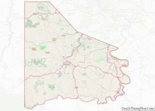
Monongahela location map. Where is Monongahela city?


History
Monongahela was founded in 1769 on a tract of land near the confluence of Pigeon Creek and the Monongahela River. It is the oldest settlement in the Monongahela River Valley and most likely the oldest in Washington County. The word Monongahela is Native American in origin, meaning “falling banks”. The Monongahela tribe was also indigenous to the area prior to the settlement of the city.
The original tract of land was actually owned by three different men, who named their land areas Eden, Paradise, and Gloucester. Joseph Parkison, who operated a ferry on the west bank of the Monongahela River, is recognized as the founder of the city. Parkison built the town’s first post office, and in 1782 the town was officially recognized as Parkison’s Ferry. Adam Wickerham took claim to 130 acres (0.53 km) on the Parkison Ferry tract on July 1, 1788. On this tract he laid out Georgetown in 1807. Georgetown was made part of Williamsport by Wickerham on February 23, 1816. In 1833, the first borough officers were elected for Williamsport. On April 1, 1837, Williamsport was given the name Monongahela City and in 1893 shortened to Monongahela.
The Edward G. Acheson House, Bethel African Methodist Episcopal Church of Monongahela City, David Longwell House, and Monongahela Cemetery are listed on the National Register of Historic Places.
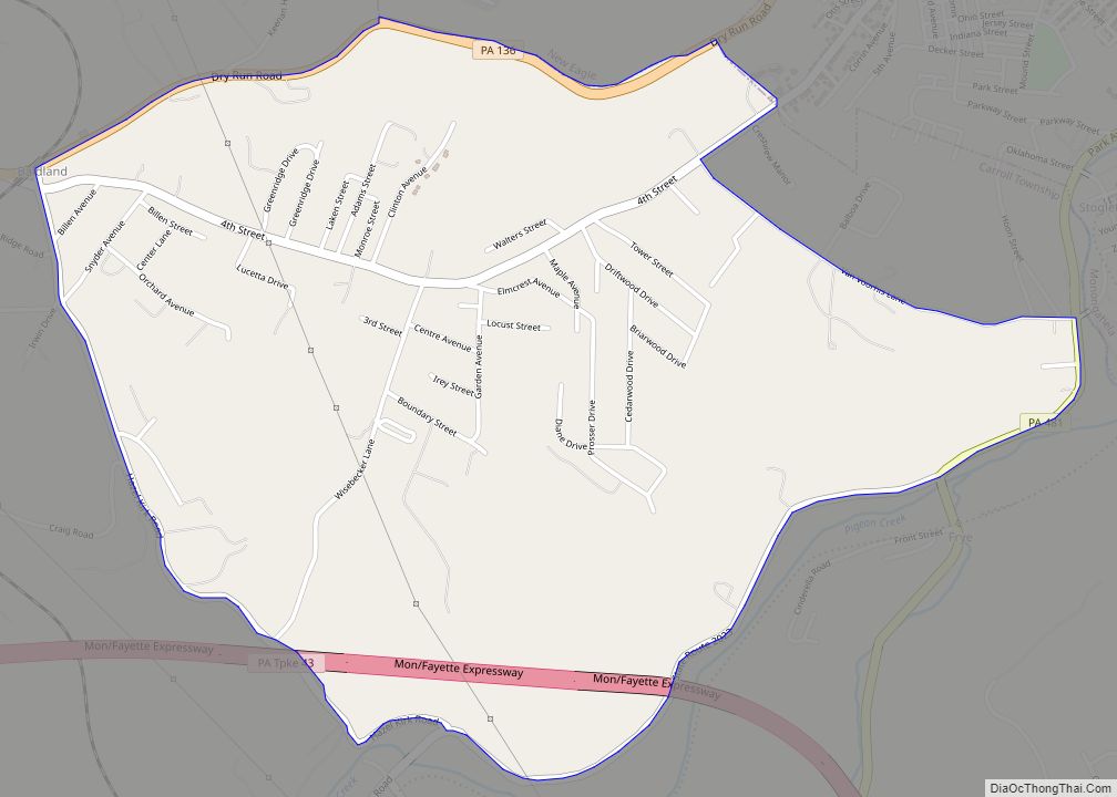
Monongahela Road Map

Monongahela city Satellite Map

Geography
Monongahela is located at 40°12′2″N 79°55′42″W / 40.20056°N 79.92833°W / 40.20056; -79.92833 (40.200462, -79.928394).
According to the United States Census Bureau, the city has a total area of 2.1 square miles (5.4 km), of which 1.9 square miles (4.9 km) is land and 0.2 square miles (0.52 km) (9.86%) is water.
The city receives 37.65 inches (956 mm) of rainfall annually and has a mean annual temperature of 63 °F (17 °C).
Surrounding and adjacent neighborhoods
Monongahela has two land borders, with Carroll Township to the east and south, and New Eagle to the west. Across the Monongahela River, the Allegheny County municipality of Forward Township runs adjacent to the city.
See also
Map of Pennsylvania State and its subdivision:- Adams
- Allegheny
- Armstrong
- Beaver
- Bedford
- Berks
- Blair
- Bradford
- Bucks
- Butler
- Cambria
- Cameron
- Carbon
- Centre
- Chester
- Clarion
- Clearfield
- Clinton
- Columbia
- Crawford
- Cumberland
- Dauphin
- Delaware
- Elk
- Erie
- Fayette
- Forest
- Franklin
- Fulton
- Greene
- Huntingdon
- Indiana
- Jefferson
- Juniata
- Lackawanna
- Lancaster
- Lawrence
- Lebanon
- Lehigh
- Luzerne
- Lycoming
- Mc Kean
- Mercer
- Mifflin
- Monroe
- Montgomery
- Montour
- Northampton
- Northumberland
- Perry
- Philadelphia
- Pike
- Potter
- Schuylkill
- Snyder
- Somerset
- Sullivan
- Susquehanna
- Tioga
- Union
- Venango
- Warren
- Washington
- Wayne
- Westmoreland
- Wyoming
- York
- Alabama
- Alaska
- Arizona
- Arkansas
- California
- Colorado
- Connecticut
- Delaware
- District of Columbia
- Florida
- Georgia
- Hawaii
- Idaho
- Illinois
- Indiana
- Iowa
- Kansas
- Kentucky
- Louisiana
- Maine
- Maryland
- Massachusetts
- Michigan
- Minnesota
- Mississippi
- Missouri
- Montana
- Nebraska
- Nevada
- New Hampshire
- New Jersey
- New Mexico
- New York
- North Carolina
- North Dakota
- Ohio
- Oklahoma
- Oregon
- Pennsylvania
- Rhode Island
- South Carolina
- South Dakota
- Tennessee
- Texas
- Utah
- Vermont
- Virginia
- Washington
- West Virginia
- Wisconsin
- Wyoming