Ridley Park is a borough in Delaware County, Pennsylvania, United States. The population was 7,002 at the 2010 census. Ridley Park is the home of The Boeing Company’s CH-47 Chinook helicopter division.
| Name: | Ridley Park borough |
|---|---|
| LSAD Code: | 21 |
| LSAD Description: | borough (suffix) |
| State: | Pennsylvania |
| County: | Delaware County |
| Elevation: | 89 ft (27 m) |
| Total Area: | 1.08 sq mi (2.81 km²) |
| Land Area: | 1.08 sq mi (2.79 km²) |
| Water Area: | 0.01 sq mi (0.01 km²) |
| Total Population: | 7,002 |
| Population Density: | 6,547.73/sq mi (2,528.45/km²) |
| ZIP code: | 19078 |
| FIPS code: | 4264832 |
| Website: | www.ridleyparkborough.org |
Online Interactive Map
Click on ![]() to view map in "full screen" mode.
to view map in "full screen" mode.
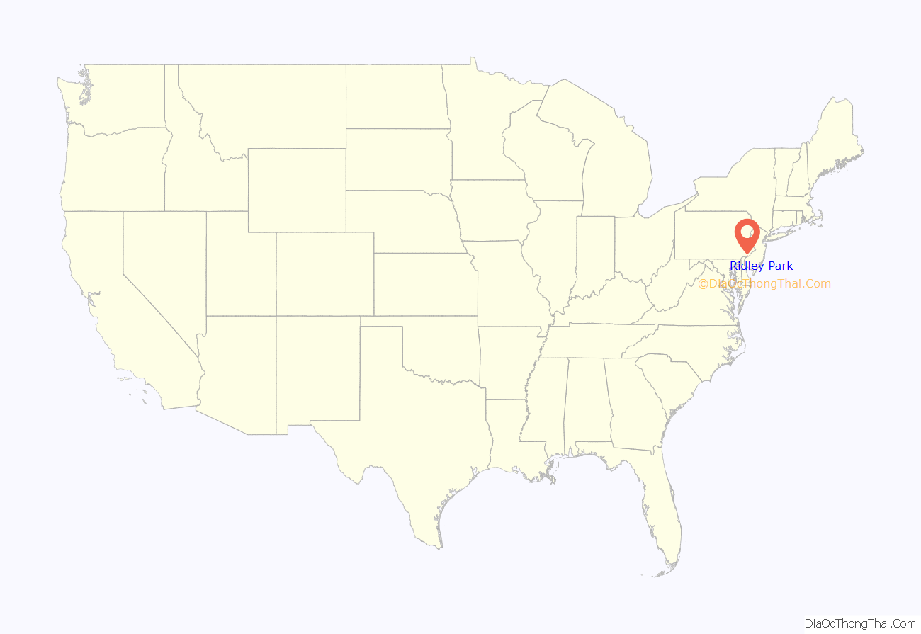
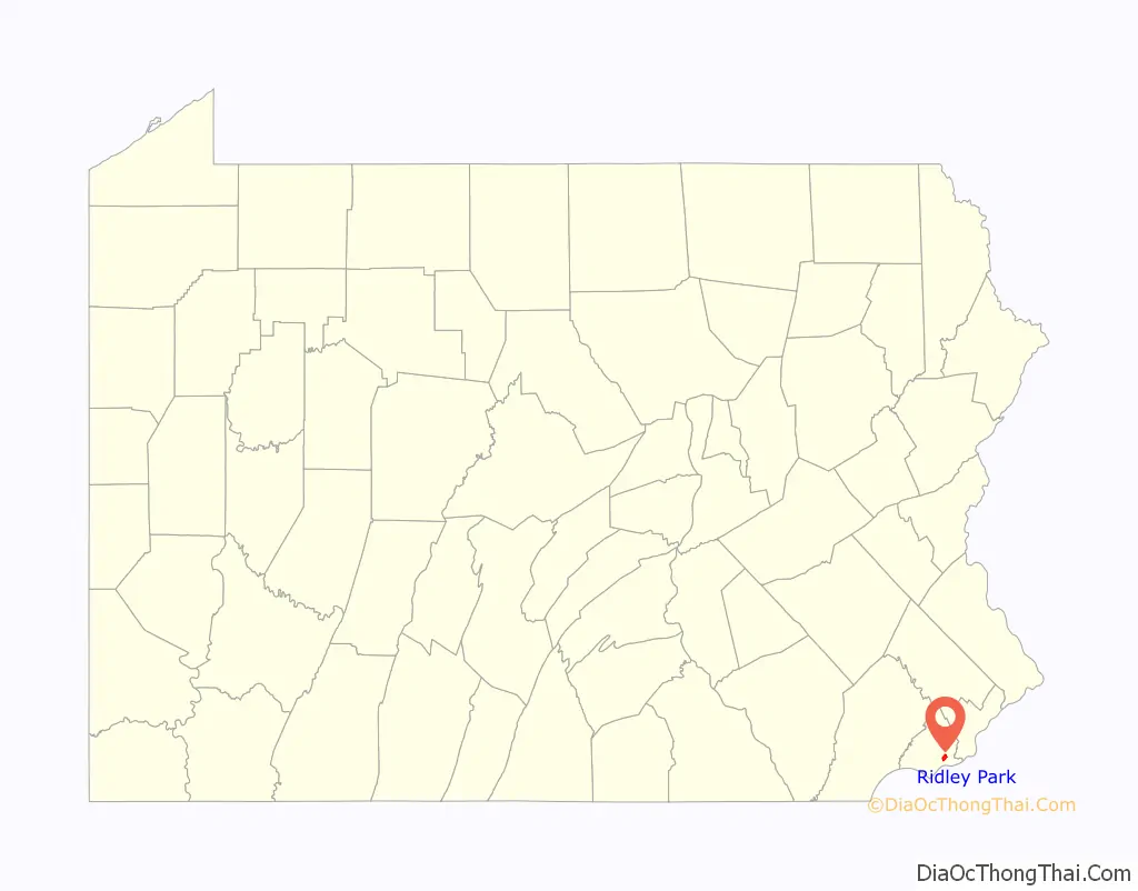
Ridley Park location map. Where is Ridley Park borough?
History
Native American
The Lenape inhabited the Delaware River region several centuries before the arrival of European explorers and traders. The Okehocking Tribe of the Lenni Lenape Nation established small permanent villages along the river and its main tributaries. Land adjacent to Stoney Creek in Ridley Township has been identified as a Native American town site. Historians also believe that additional villages may have existed at other locations along Stoney Creek and Crum Creek in Ridley Park. Native Americans significantly influenced the built environment through their network of paths laid out for travel and communication purposes. Their footpaths through the densely forested countryside grew into the first roads of the area. Chester Pike is believed to have developed from a footpath created by the Lenni Lenape as their main thoroughfare in the area.
Colonial
The borough is named after a place in Cheshire, England. John Morton, signer of the American Declaration of Independence, was born and raised in a log cabin adjacent to East Ridley Avenue. He later replaced the cabin with a brick house and began farming 133 acres (0.54 km) in the Ridley Park area. Chester Pike, originally a footpath, was realigned and widened by William Penn. Known then as the “Queens Highway,” it was one of the region’s first roads stretching from Chester to Darby, and by 1715, it reached Philadelphia. General George Washington led his troops down this earthen road to Wilmington and eventually to Brandywine to confront the British in 1777. In 1799, the “Queens Highway” was improved as a plank road, and tolls were levied. The population of the area continued to increase after the American Revolutionary War. Consequently, a private elementary subscription school was founded in 1800 on a site at Chester Pike and Myrtle Avenue. This was one of the first schools in Delaware County.
Railroad suburb
Ridley Park was founded by Isaac Hinckley in 1871. He was the President of the Philadelphia, Wilmington & Baltimore Railroad. He wanted to expand the company’s rail line to gain more business in the same way the Pennsylvania Railroad had earlier created a Main Line from 30th Street Station in Philadelphia to Paoli. The Pennsylvania Railroad bought up farmland and developed towns all along its rail line. City dwellers, seeking relief from the urban crowds with their potential to spread malaria, a disease that was a major health concern at the time, quickly purchased the new homes being built.
Seeing the success of this, Hinckley came up with the idea of putting in a rail line that would pass through Darby and continue all the way to the semi-rural city of Chester in what became known as the Darby Improvement Hinckley’s plans met with initial resistance from farmers, and at the end of the first year, he had managed to buy only one farm. Undaunted, he traveled further south on Chester Pike to the area now known as Ridley Park.
In an effort to avoid his previous bad experience, in May 1871, Hinckley formed an association to acquire the land. Hinckley hired Robert Morris Copeland, a noted Boston landscape architect, to develop a master plan for a suburban park community which became known as the Borough of Ridley Park. Copeland’s design is Delaware County’s first planned community. Because of its beautifully landscaped streets and parks, and its 20-acre (81,000 m) man-made lake, Ridley Park became popular in the late 19th century and early part of the 20th century as a summer resort for wealthy Philadelphians who built most of the Victorian style homes still lived in today.
Between January and May 1870, many farms were purchased. The streets in the new development were named after the families who sold their farmland. Names such as Burk, Dutton, Free, Henderson, Stewart and Ward, are still used today. The first train of passengers-cars stopped at Ridley Park on October 19, 1872. By that time, the town had a hotel, and a dam had been built across Crum Creek, creating a 20-acre (81,000 m) lake. By 1880, the U.S. census return recorded the population of Ridley Park as 439. The railroad was, and continues today to be an integral part of the town.
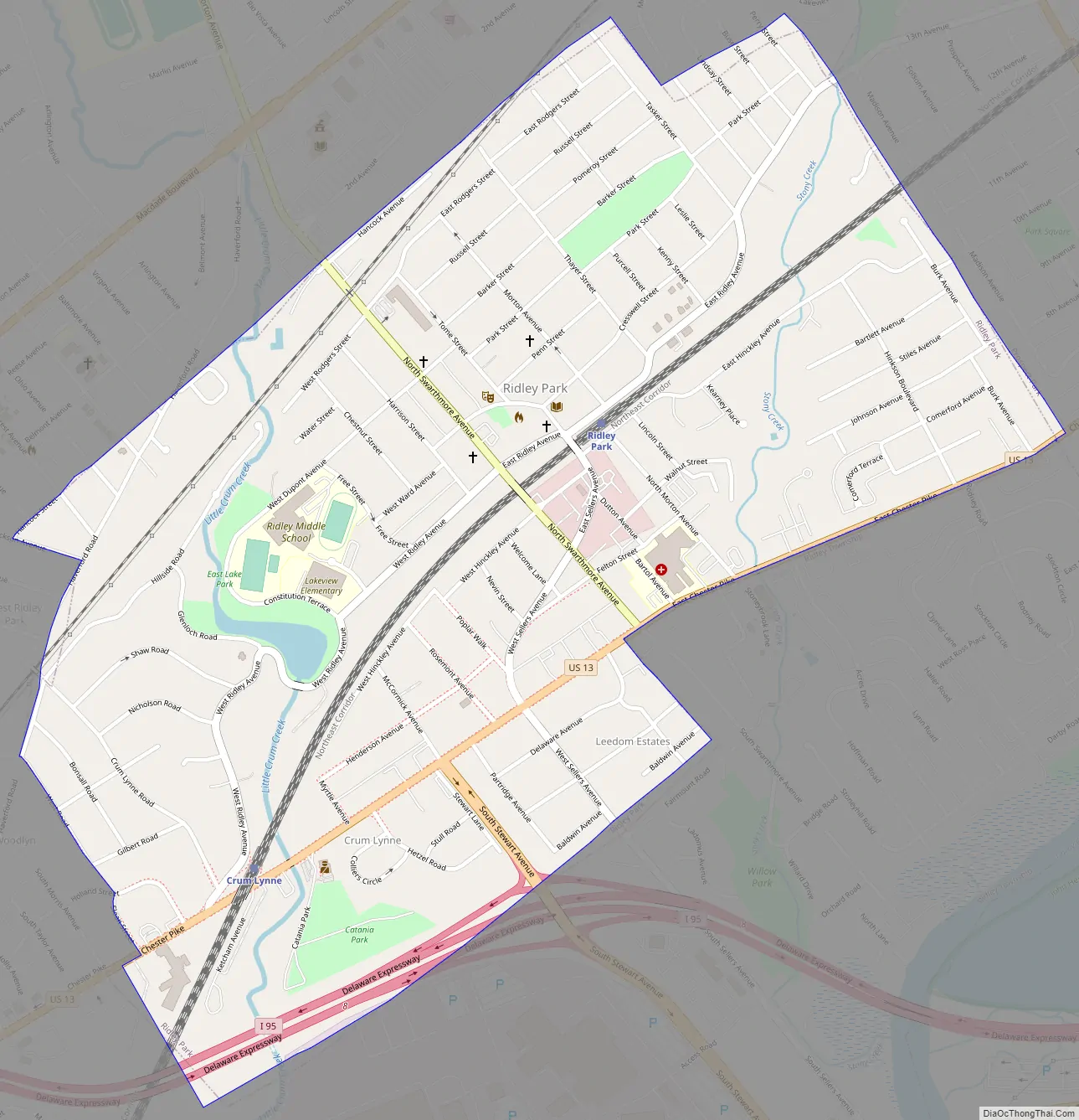
Ridley Park Road Map
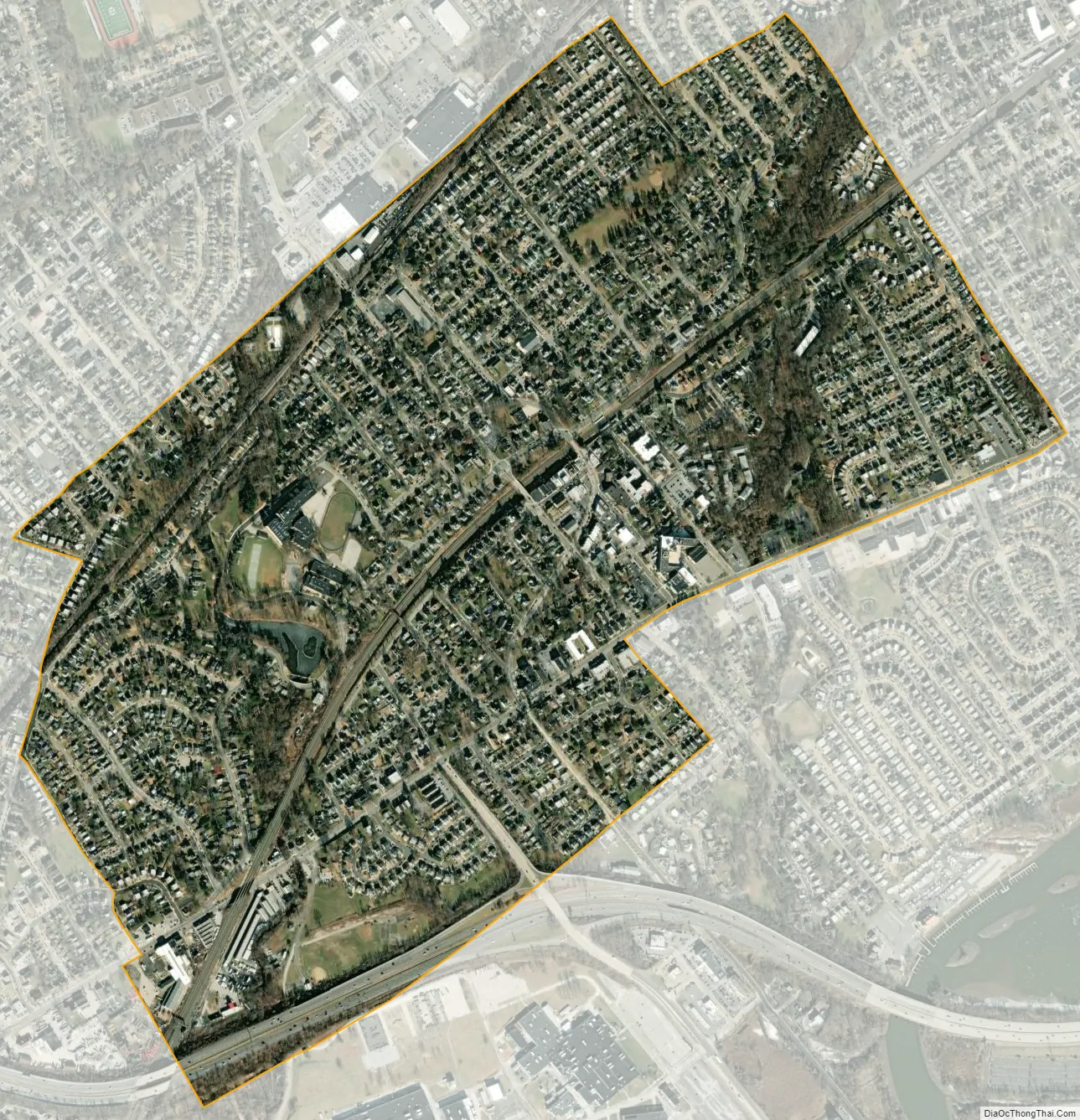
Ridley Park city Satellite Map
Geography
Ridley Park is located at 39°52′47″N 75°19′32″W / 39.87972°N 75.32556°W / 39.87972; -75.32556 (39.879631, -75.325482).
According to the United States Census Bureau, the borough has a total area of 1.1 square miles (2.8 km), of which 1.1 square miles (2.8 km) is land and 0.93% is water. It has a humid subtropical climate (Cfa) and average monthly temperatures range from 33.4 °F in January to 78.2 °F in July. [1] The hardiness zone is 7a, bordering upon 7b. [2]
See also
Map of Pennsylvania State and its subdivision:- Adams
- Allegheny
- Armstrong
- Beaver
- Bedford
- Berks
- Blair
- Bradford
- Bucks
- Butler
- Cambria
- Cameron
- Carbon
- Centre
- Chester
- Clarion
- Clearfield
- Clinton
- Columbia
- Crawford
- Cumberland
- Dauphin
- Delaware
- Elk
- Erie
- Fayette
- Forest
- Franklin
- Fulton
- Greene
- Huntingdon
- Indiana
- Jefferson
- Juniata
- Lackawanna
- Lancaster
- Lawrence
- Lebanon
- Lehigh
- Luzerne
- Lycoming
- Mc Kean
- Mercer
- Mifflin
- Monroe
- Montgomery
- Montour
- Northampton
- Northumberland
- Perry
- Philadelphia
- Pike
- Potter
- Schuylkill
- Snyder
- Somerset
- Sullivan
- Susquehanna
- Tioga
- Union
- Venango
- Warren
- Washington
- Wayne
- Westmoreland
- Wyoming
- York
- Alabama
- Alaska
- Arizona
- Arkansas
- California
- Colorado
- Connecticut
- Delaware
- District of Columbia
- Florida
- Georgia
- Hawaii
- Idaho
- Illinois
- Indiana
- Iowa
- Kansas
- Kentucky
- Louisiana
- Maine
- Maryland
- Massachusetts
- Michigan
- Minnesota
- Mississippi
- Missouri
- Montana
- Nebraska
- Nevada
- New Hampshire
- New Jersey
- New Mexico
- New York
- North Carolina
- North Dakota
- Ohio
- Oklahoma
- Oregon
- Pennsylvania
- Rhode Island
- South Carolina
- South Dakota
- Tennessee
- Texas
- Utah
- Vermont
- Virginia
- Washington
- West Virginia
- Wisconsin
- Wyoming


