Cerritos (Spanish for “Little hills”) is a city in Los Angeles County, California, United States, and is one of several cities that constitute the Gateway Cities of southeast Los Angeles County. It was incorporated on April 24, 1956. As of 2019, the population was 49,859. It is part of the Los Angeles–Long Beach–Anaheim, California Metropolitan Statistical Area designated by the Office of Management and Budget.
| Name: | Cerritos city |
|---|---|
| LSAD Code: | 25 |
| LSAD Description: | city (suffix) |
| State: | California |
| County: | Los Angeles County |
| Incorporated: | April 24, 1956 |
| Elevation: | 46 ft (14 m) |
| Total Area: | 8.86 sq mi (22.94 km²) |
| Land Area: | 8.73 sq mi (22.60 km²) |
| Water Area: | 0.13 sq mi (0.34 km²) 1.48% |
| Total Population: | 49,578 |
| Population Density: | 5,680.99/sq mi (2,193.45/km²) |
| Area code: | 562 |
| FIPS code: | 0612552 |
| Website: | www.cerritos.us |
Online Interactive Map
Click on ![]() to view map in "full screen" mode.
to view map in "full screen" mode.
Cerritos location map. Where is Cerritos city?


History
Cerritos was originally inhabited by Native Americans belonging to the Tongva (or “People of the Earth”). The Tongva were called the “Gabrieleños” by the Spanish settlers after the nearby Mission San Gabriel Arcángel. The Tongva were the largest group of indigenous peoples in Southern California as well as the most developed in the region. The Tongva lived off the land, deriving food from the animals or plants that could be gathered, snared or hunted, and grinding acorns as a staple.
Beginning in the late 15th century, Spanish explorers arrived in the New World and worked their way to the California coast in 1542. The colonization process included “civilizing” the native populations in California by establishing various missions. Soon afterward, a town called El Pueblo de Nuestra Señora la Reina de los Ángeles de Porciúncula (Los Angeles today) would be founded and prosper with the aid of subjects from New Spain and Native American labor.
One soldier, José Manuel Nieto, was granted a large plot of land by the Spanish King Carlos III, which he named Rancho Los Nietos. It covered 300,000 acres (120,000 hectares) of what are today the cities of Cerritos, Long Beach, Lakewood, Downey, Norwalk, Santa Fe Springs, part of Whittier, Huntington Beach, Buena Park and Garden Grove.
The rancho was divided five ways among Nieto’s heirs during the nationalization of church property by the Mexican government, with Juan José Nieto retaining the largest plot, called Rancho Los Coyotes. Nieto called the area of Rancho Los Coyotes “cerritos” or “little hills”.
After the Mexican–American War, the rancho would eventually wind up in the hands of the Los Angeles and San Bernardino Land Company, which encouraged development and rail lines to be built by Henry E. Huntington and his Pacific Electric Railway company. It was through rapid development, combined with improved transportation systems, that the modern-day city of Artesia was formed in Rancho Los Coyotes in 1875, and from it, the city of Dairy Valley.
Cranford Airport, a small general-aviation airport, was built around 1946 and consisted of two 2,300-foot runways, one oriented north–south & the other northeast–southwest. Each runway had a parallel taxiway, and a ramp along the south side of the field had two building hangars. The former airport site is on the northwest corner of the intersection of South Street & Carmenita Road. Cranford Airport closed at some point between 1953 and 1954.
The city of Dairy Valley was incorporated on April 24, 1956, as a reaction to nearby Artesia’s rapid urbanization. The city’s name symbolized the more than 400 dairies, 100,000 cows and 106,300 chickens found within its limits. The cows outnumbered the 3,439 residents by a factor of 29 to 1. The chickens outnumbered the residents by over 30 to 1. The first business license in the new city was for Walter Marlowe’s “Dairy Valley Egg Farms”.
Two years later, Dairy Valley voted to become a chartered California city. As land values and property taxes in California rose in the early 1960s, agriculture became increasingly unprofitable, and development pressures increased. In a special election held on July 16, 1963, residents voted to permit large-scale residential development. As a reflection of its newly planned suburban orientation, the city’s name was formally changed to Cerritos on January 10, 1967, after the nearby Spanish land grant Rancho Los Cerritos, which figured prominently in the region, and after Cerritos College in neighboring Norwalk.
Cerritos is a prime example of the “fiscalization” of California politics after the tax revolt of the 1970s and the passage of Proposition 13. The only way for California cities to raise long-term tax revenue in light of Proposition 13 was to create as many commercial zones as possible to take advantage of the percentage of county sales tax allocated back to municipalities as sales tax revenue. Cerritos was one of the first cities in Los Angeles County to develop large-scale retail zones, such as the Los Cerritos Center and Cerritos Auto Square, and achieved stunning success. City leaders reinvested funds into the community with large public works projects and an increasing number of community services and programs.
The current progressive nature of the Cerritos government and the unusually strong tax base is best reflected in its facilities. In 1978, Cerritos dedicated the nation’s first solar-heated City Hall complex. In 1993, the Cerritos Center for the Performing Arts opened its doors. In 1994, the City unveiled the Cerritos Towne Center project, combining office, retail, lodging, fine arts and dining in an open-air location. In 1997, the city opened the Cerritos Sheriff’s Station/Community Safety Center to provide public safety services. In 2002, the City rededicated its public library. In 2006, the City celebrated its golden anniversary with memorials and the unveiling of a sculpture garden. The assessed valuation of the city is $7,177,428,066.
Between 1970 and 1972, Cerritos was the fastest-growing city in California; the population skyrocketed from 16,000 to 38,000. Since the 1980s, Cerritos has attracted a large number of Filipino, Korean, Taiwanese, Indian and Chinese immigrant families.
On August 31, 1986, Aeroméxico Flight 498, on approach to Los Angeles International Airport from Mexico City, was struck by a small Piper aircraft that had strayed into a Terminal Control Area without clearance from Air Traffic Control. The Piper crashed into Cerritos Elementary School’s unoccupied playground, but the Douglas DC-9 fell inverted (upside-down) and plowed into dense residential zones, immediately flattening four houses. The resulting fire destroyed eight more houses before firefighters could bring it under control. A total of 82 people died, including 15 people on the ground. A sculpture in the Cerritos Sculpture Garden memorializes the incident.
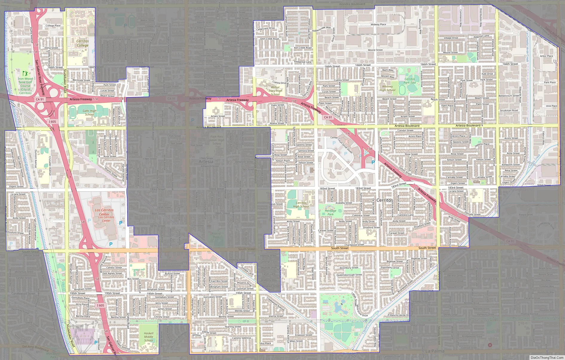
Cerritos Road Map
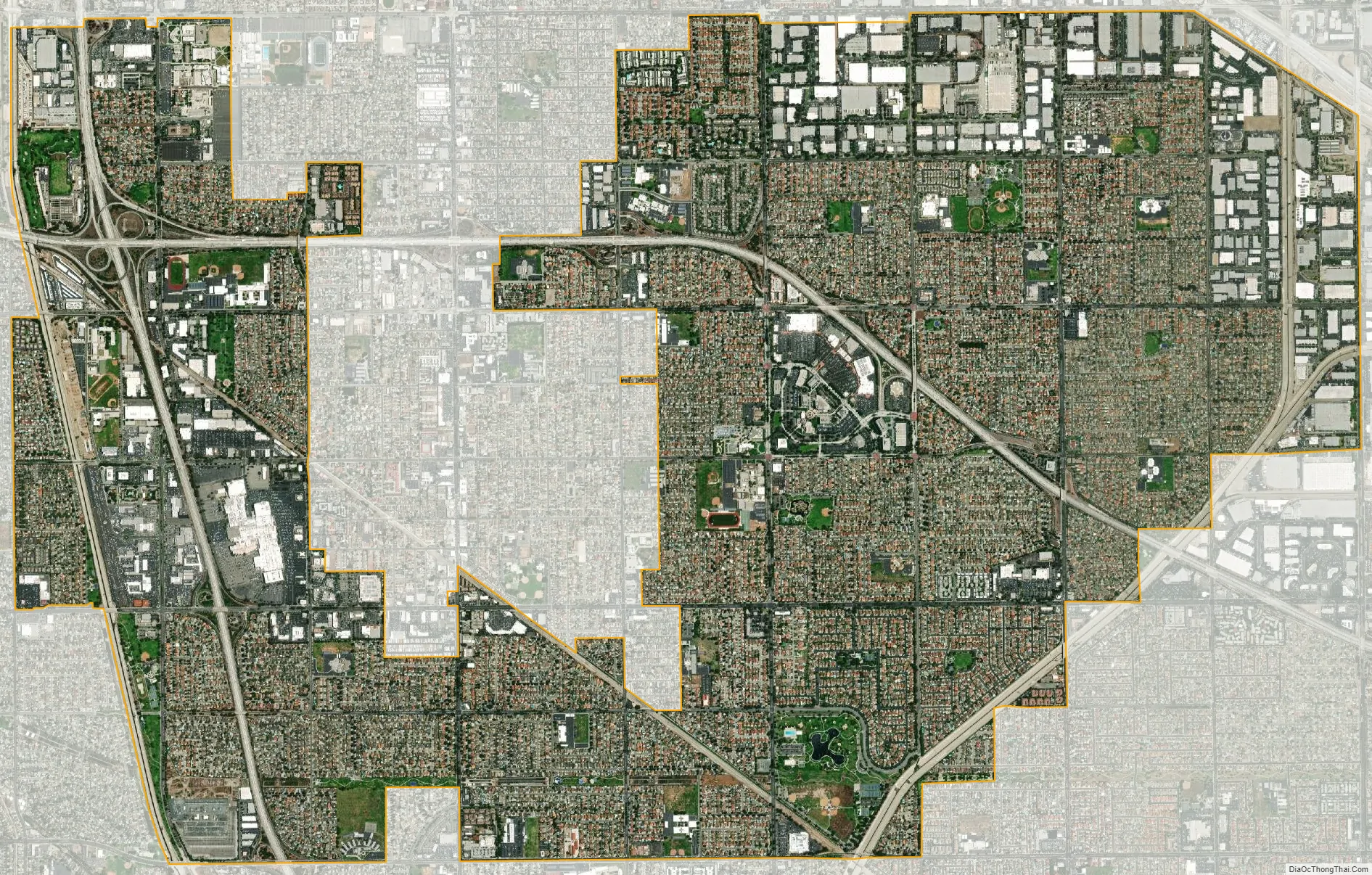
Cerritos city Satellite Map
Geography
According to the United States Census Bureau, the city has a total area of 8.9 square miles (23.05 km); 8.7 square miles (22.53 km) of it is land and 0.1 square miles (0.26 km) of it (1.48%) is water.
Cerritos lies along the Los Angeles County and Orange County border. The cities bordering Cerritos on the Los Angeles County side include Artesia in the center, Bellflower, Lakewood, Norwalk, Santa Fe Springs and La Mirada. Buena Park and La Palma border the city on the Orange County side. Other cities in the region include Cypress in Orange County, and Hawaiian Gardens and Long Beach in Los Angeles County.
The former postal ZIP code of Cerritos was 90701 and was shared with the city of Artesia; however, it was later changed to the exclusive 90703 to accommodate the increasing number of new addresses in the city during the mid-1990s.
Climate
Cerritos, as well as most of coastal Southern California, generally has a Mediterranean climate. Summers are warm to hot, and winters are mild, rarely falling below freezing. Precipitation occurs predominantly during the winter months.
Cerritos also has a unique “semi-marine” climate pattern within Los Angeles County. The fog that typically covers the beach cities rarely reaches Cerritos, but the breeze that comes along the San Gabriel River from the Pacific Ocean has a significant cooling effect. As a result, Cerritos is rarely affected by the smog, Santa Ana winds and smothering heat of the Los Angeles Basin.
See also
Map of California State and its subdivision:- Alameda
- Alpine
- Amador
- Butte
- Calaveras
- Colusa
- Contra Costa
- Del Norte
- El Dorado
- Fresno
- Glenn
- Humboldt
- Imperial
- Inyo
- Kern
- Kings
- Lake
- Lassen
- Los Angeles
- Madera
- Marin
- Mariposa
- Mendocino
- Merced
- Modoc
- Mono
- Monterey
- Napa
- Nevada
- Orange
- Placer
- Plumas
- Riverside
- Sacramento
- San Benito
- San Bernardino
- San Diego
- San Francisco
- San Joaquin
- San Luis Obispo
- San Mateo
- Santa Barbara
- Santa Clara
- Santa Cruz
- Shasta
- Sierra
- Siskiyou
- Solano
- Sonoma
- Stanislaus
- Sutter
- Tehama
- Trinity
- Tulare
- Tuolumne
- Ventura
- Yolo
- Yuba
- Alabama
- Alaska
- Arizona
- Arkansas
- California
- Colorado
- Connecticut
- Delaware
- District of Columbia
- Florida
- Georgia
- Hawaii
- Idaho
- Illinois
- Indiana
- Iowa
- Kansas
- Kentucky
- Louisiana
- Maine
- Maryland
- Massachusetts
- Michigan
- Minnesota
- Mississippi
- Missouri
- Montana
- Nebraska
- Nevada
- New Hampshire
- New Jersey
- New Mexico
- New York
- North Carolina
- North Dakota
- Ohio
- Oklahoma
- Oregon
- Pennsylvania
- Rhode Island
- South Carolina
- South Dakota
- Tennessee
- Texas
- Utah
- Vermont
- Virginia
- Washington
- West Virginia
- Wisconsin
- Wyoming


