San Ramon (Spanish: San Ramón, meaning “St. Raymond”) is a city in Contra Costa County, California, United States, located within the San Ramon Valley, and 34 miles (55 km) east of San Francisco. San Ramon’s population was 84,605 per the 2020 census, making it the 4th largest city in Contra Costa County, behind Richmond, Concord and Antioch.
San Ramon is home to the headquarters of Chevron Corporation, Cooper Companies, the West Coast headquarters of AT&T, GE Digital, as well as the San Ramon Medical Center. Major annual events include the Art and Wind Festival on Memorial Day weekend and the Run for Education in October.
On April 24, 2001, San Ramon was designated a Tree City USA.
| Name: | San Ramon city |
|---|---|
| LSAD Code: | 25 |
| LSAD Description: | city (suffix) |
| State: | California |
| County: | Contra Costa County |
| Incorporated: | July 1, 1983 |
| Elevation: | 486 ft (148 m) |
| Total Area: | 18.72 sq mi (48.48 km²) |
| Land Area: | 18.68 sq mi (48.39 km²) |
| Water Area: | 0.03 sq mi (0.09 km²) 0.09% |
| Total Population: | 84,605 |
| Population Density: | 4,500/sq mi (1,700/km²) |
| ZIP code: | 94582, 94583 |
| Area code: | 925 |
| FIPS code: | 0668378 |
| Website: | www.ci.san-ramon.ca.us |
Online Interactive Map
Click on ![]() to view map in "full screen" mode.
to view map in "full screen" mode.
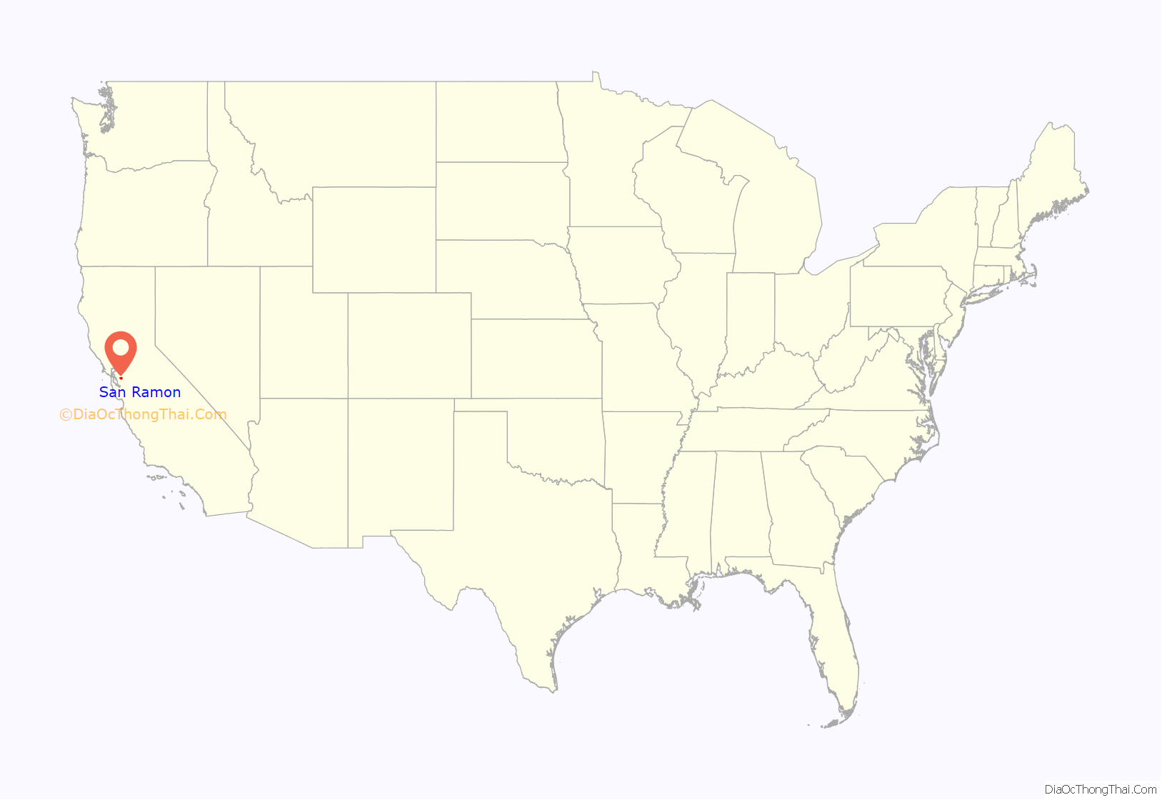
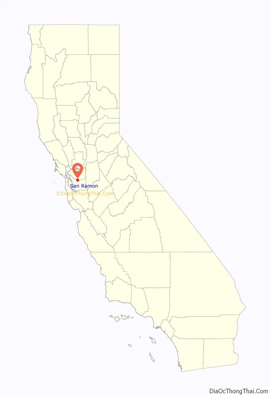
San Ramon location map. Where is San Ramon city?
History
The lands now occupied by the City of San Ramon were formerly inhabited by Seunen people, an Ohlone/Costanoan group who built their homes near creeks. Sometime around 1797, they were taken by Mission San José for use as grazing land. In 1834, they were part of the Rancho San Ramon land grant to José María Amador.
Amador named San Ramón (Spanish for ‘Saint Raymond’) not after a real saint but rather after a Native American vaquero who tended mission sheep on the land. Amador added the “San” per Spanish custom. In 1850, the first permanent American settlers, Leo and Mary Jane Norris, purchased the northwest corner of Amador’s Rancho San Ramon, near the intersection of present-day Bollinger Canyon Road and Crow Canyon Road.
The tracks for the San Ramon Branch Line of the Southern Pacific Railroad were laid down and completed in 1891. The line extended from San Ramon to an unincorporated area known as Avon, east of Martinez, where it connected to the Oakland/Stockton Line. On February 7, 1909, Southern Pacific extended the line south to Radum (near Pleasanton). In 1934, passenger service ended. By 1986, Contra Costa County had obtained the railroad right-of-way and the Iron Horse Regional Trail was established along its path.
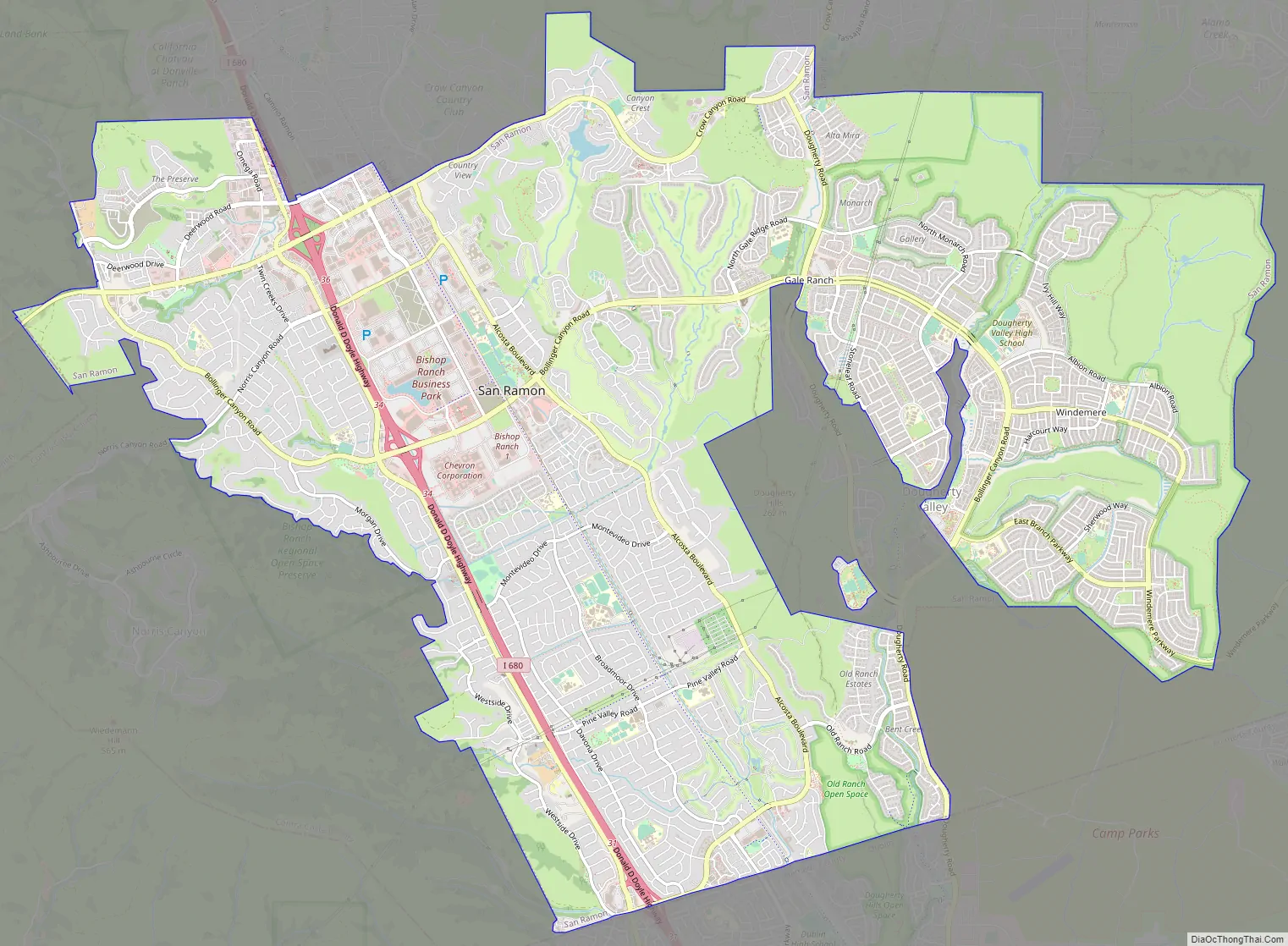
San Ramon Road Map
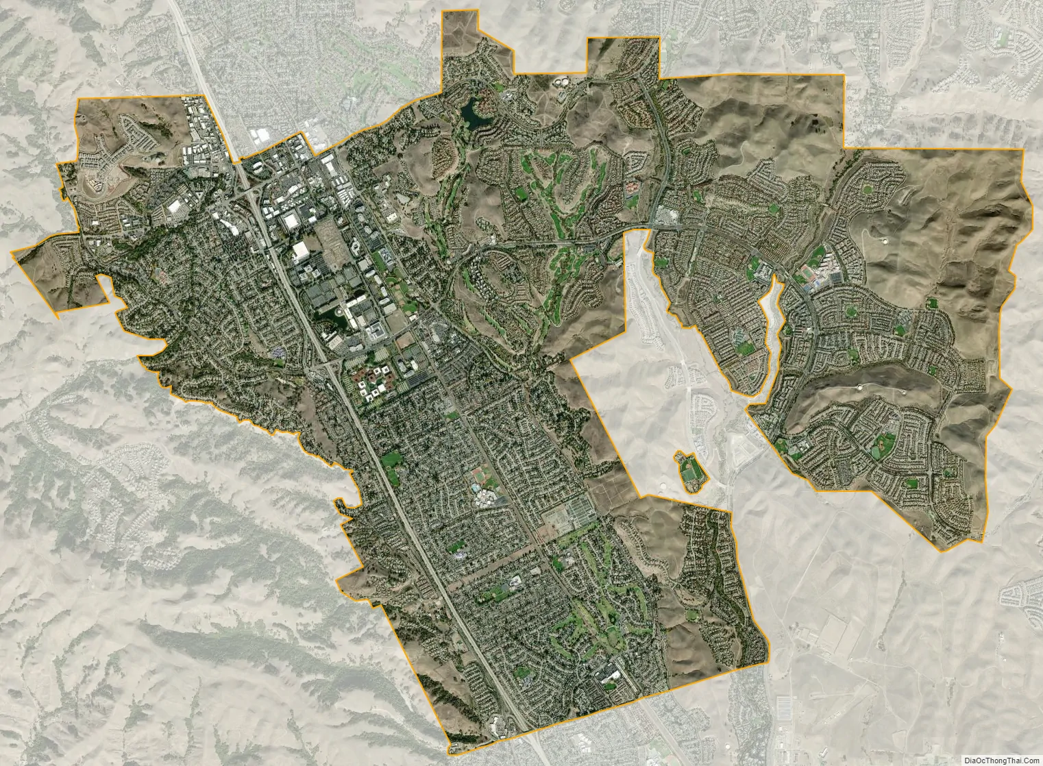
San Ramon city Satellite Map
Geography
Mount Diablo flanks the city to the northeast and is prominently visible from almost all parts of the city. The Las Trampas Regional Wilderness borders San Ramon’s extreme northwest, at the northern end of Bollinger Canyon. The smaller Bishop Ranch Regional Preserve straddles San Ramon’s western border, located approximately between Interstate 680 and the Alameda County line.
The topography of San Ramon is varied, featuring a mix of the rolling hills of the Diablo Range and the flatter basin of the San Ramon Valley. The city is predominantly urban and residential with many new housing developments; however, much of the land around the city’s perimeter regions remains undeveloped, and is covered by grasslands and oak tree orchards. During the drier months the grasses are golden, but with the precipitation of winter and spring, the grasses turn green.
Climate
San Ramon’s weather typifies a Mediterranean climate, seasonal, and moderate. Summers can range from warm to hot and dry, while winters are mild or cool, wet and rather short. Its weather is similar to the adjacent cities of Danville, Dublin and Pleasanton. Fog can be infrequent but occurs normally in the western reaches of the city, at the eastern mouth of Crow Canyon, through which marine weather patterns funnel in from the San Francisco Bay via Castro Valley. It usually burns off by mid-to-late morning.
See also
Map of California State and its subdivision:- Alameda
- Alpine
- Amador
- Butte
- Calaveras
- Colusa
- Contra Costa
- Del Norte
- El Dorado
- Fresno
- Glenn
- Humboldt
- Imperial
- Inyo
- Kern
- Kings
- Lake
- Lassen
- Los Angeles
- Madera
- Marin
- Mariposa
- Mendocino
- Merced
- Modoc
- Mono
- Monterey
- Napa
- Nevada
- Orange
- Placer
- Plumas
- Riverside
- Sacramento
- San Benito
- San Bernardino
- San Diego
- San Francisco
- San Joaquin
- San Luis Obispo
- San Mateo
- Santa Barbara
- Santa Clara
- Santa Cruz
- Shasta
- Sierra
- Siskiyou
- Solano
- Sonoma
- Stanislaus
- Sutter
- Tehama
- Trinity
- Tulare
- Tuolumne
- Ventura
- Yolo
- Yuba
- Alabama
- Alaska
- Arizona
- Arkansas
- California
- Colorado
- Connecticut
- Delaware
- District of Columbia
- Florida
- Georgia
- Hawaii
- Idaho
- Illinois
- Indiana
- Iowa
- Kansas
- Kentucky
- Louisiana
- Maine
- Maryland
- Massachusetts
- Michigan
- Minnesota
- Mississippi
- Missouri
- Montana
- Nebraska
- Nevada
- New Hampshire
- New Jersey
- New Mexico
- New York
- North Carolina
- North Dakota
- Ohio
- Oklahoma
- Oregon
- Pennsylvania
- Rhode Island
- South Carolina
- South Dakota
- Tennessee
- Texas
- Utah
- Vermont
- Virginia
- Washington
- West Virginia
- Wisconsin
- Wyoming


