Greeley is the home rule municipality city that is the county seat and the most populous municipality of Weld County, Colorado, United States. The city population was 108,795 at the 2020 United States Census, an increase of 17.12% since the 2010 United States Census. Greeley is the tenth most populous city in Colorado. Greeley is the principal city of the Greeley, CO Metropolitan Statistical Area and is a major city of the Front Range Urban Corridor. Greeley is located in northern Colorado and is situated 49 miles (79 km) north-northeast of the Colorado State Capitol in Denver.
| Name: | Greeley city |
|---|---|
| LSAD Code: | 25 |
| LSAD Description: | city (suffix) |
| State: | Colorado |
| County: | Weld County |
| Founded: | 1869 |
| Incorporated: | November 15, 1885 |
| Elevation: | 4,675 ft (1,425 m) |
| Total Area: | 49.092 sq mi (127.148 km²) |
| Land Area: | 48.933 sq mi (126.735 km²) |
| Water Area: | 0.159 sq mi (0.413 km²) |
| Total Population: | 108,795 |
| Population Density: | 2,223/sq mi (858/km²) |
| Area code: | 970 |
| FIPS code: | 0832155 |
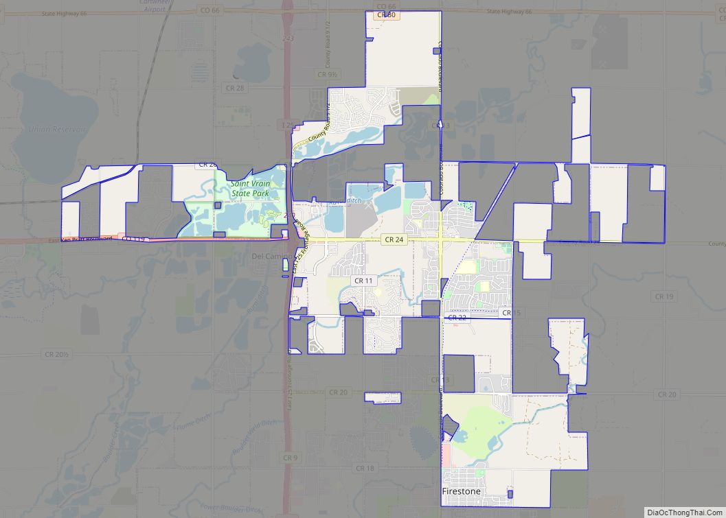
Online Interactive Map
Click on ![]() to view map in "full screen" mode.
to view map in "full screen" mode.
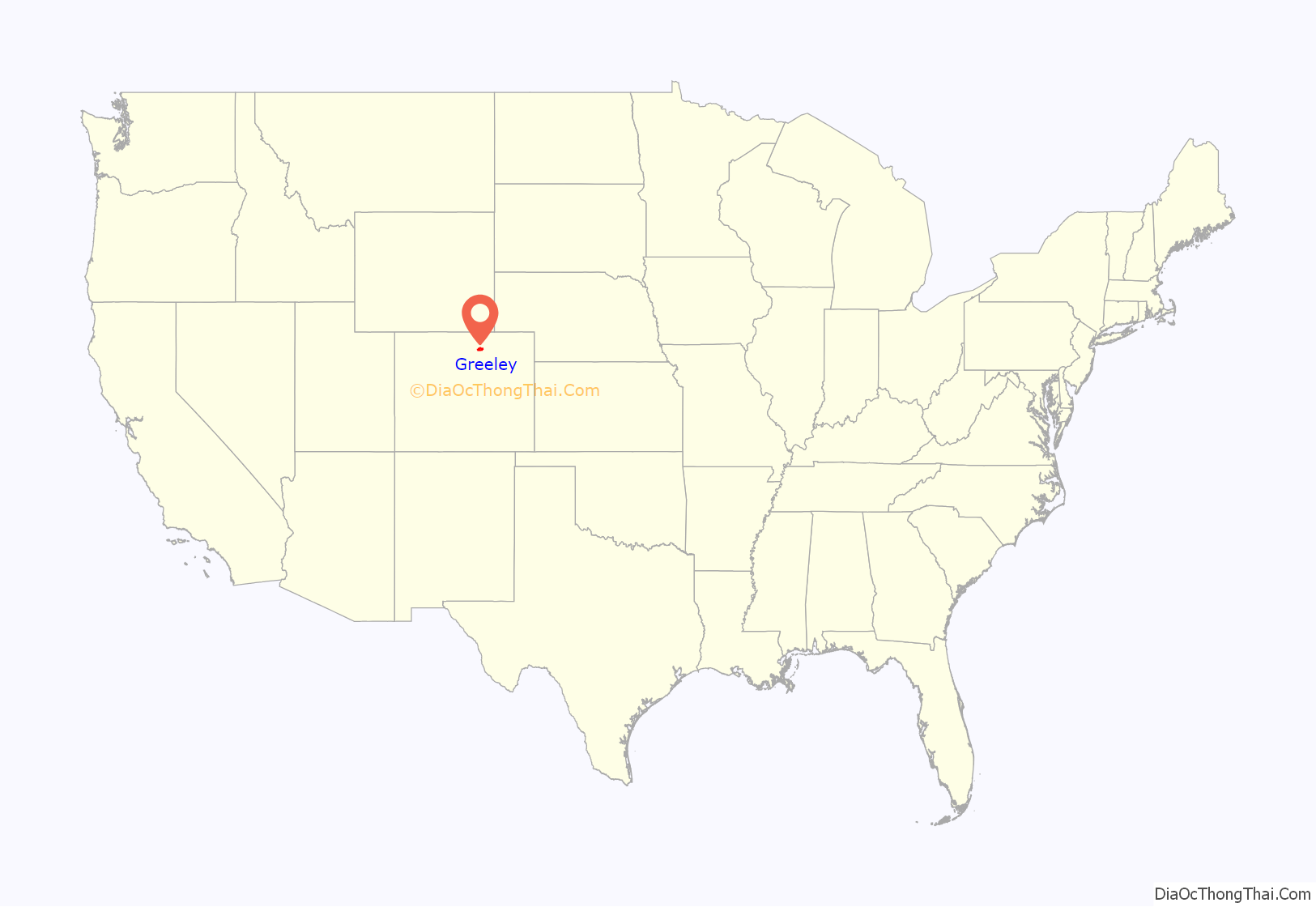
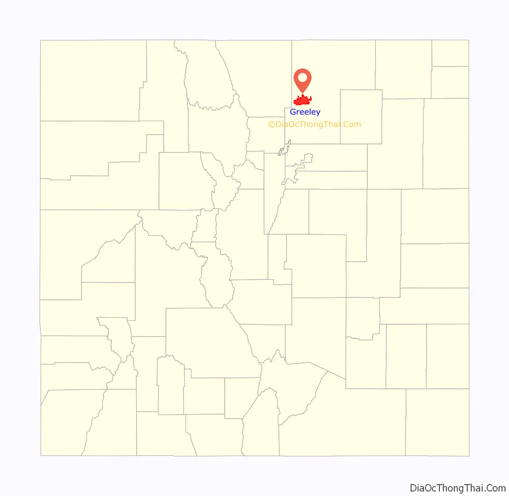
Greeley location map. Where is Greeley city?
History
Union Colony
Greeley began as the Union Colony of Colorado, which was founded in 1869 by Nathan C. Meeker, an agricultural reporter for the New York Tribune as an experimental utopian farming community “based on temperance, religion, agriculture, education and family values,” with the backing of the Tribune‘s editor Horace Greeley, who popularized the phrase “Go West, young man”. A committee which included Meeker and former Civil War general Robert Alexander Cameron traveled to Colorado to find a suitable site, and purchased 12,000 acres at the confluence of the Cache la Poudre and South Platte Rivers. The site, formerly known as the “Island Grove Ranch”, included the area of Latham, an Overland Trail station, and was halfway between Cheyenne, Wyoming and Denver, Colorado along the tracks of the Denver Pacific Railroad.
By May, 500 people had arrived to take up residence in the new colony. The name Union Colony was later changed to Greeley in honor of Horace Greeley, who had come to Colorado in the 1859 Pike’s Peak Gold Rush.
Latham
Greeley is located just west of the area previously occupied by the Overland Trail station of Latham, originally called the Cherokee City Station. The Latham station, which was also known as Fort Latham, was built in 1862 and named in honor of Milton S. Latham, one of California’s early senators. The stagecoach station was at the confluence of the South Platte River and the Cache la Poudre River. It is believed that the birth of the first white child born in Colorado, a girl, occurred there. Fort Latham was the headquarters of the government troops during the Indian conflicts of 1860–1864 and the county seat; the post office was called Latham.
Early history
Greeley was incorporated as a city on April 6, 1886.
Greeley was built on farming and agriculture, but kept up with most modern technologies as they grew. Telephones were in town by 1883 with electric lights downtown by 1886. Automobiles were on the roads alongside horse drawn buggies by 1910. A Women’s Citizens League was established there to support female suffrage.
In 1922 KFKA became one of the first radio stations to broadcast in the US and the Greeley Municipal Airport was built in 1928.
Greeley housed two POW camps in 1943, during World War II. One was for German POWs and the other was for Italian POWs. A vote to allow the sale of alcohol passed by a mere 477 votes in 1969, thus ending temperance in the city.
The Greeley Philharmonic Orchestra was started in 1911. In 1958, Greeley became the first city to have a Department of Culture.
Greeley Road Map
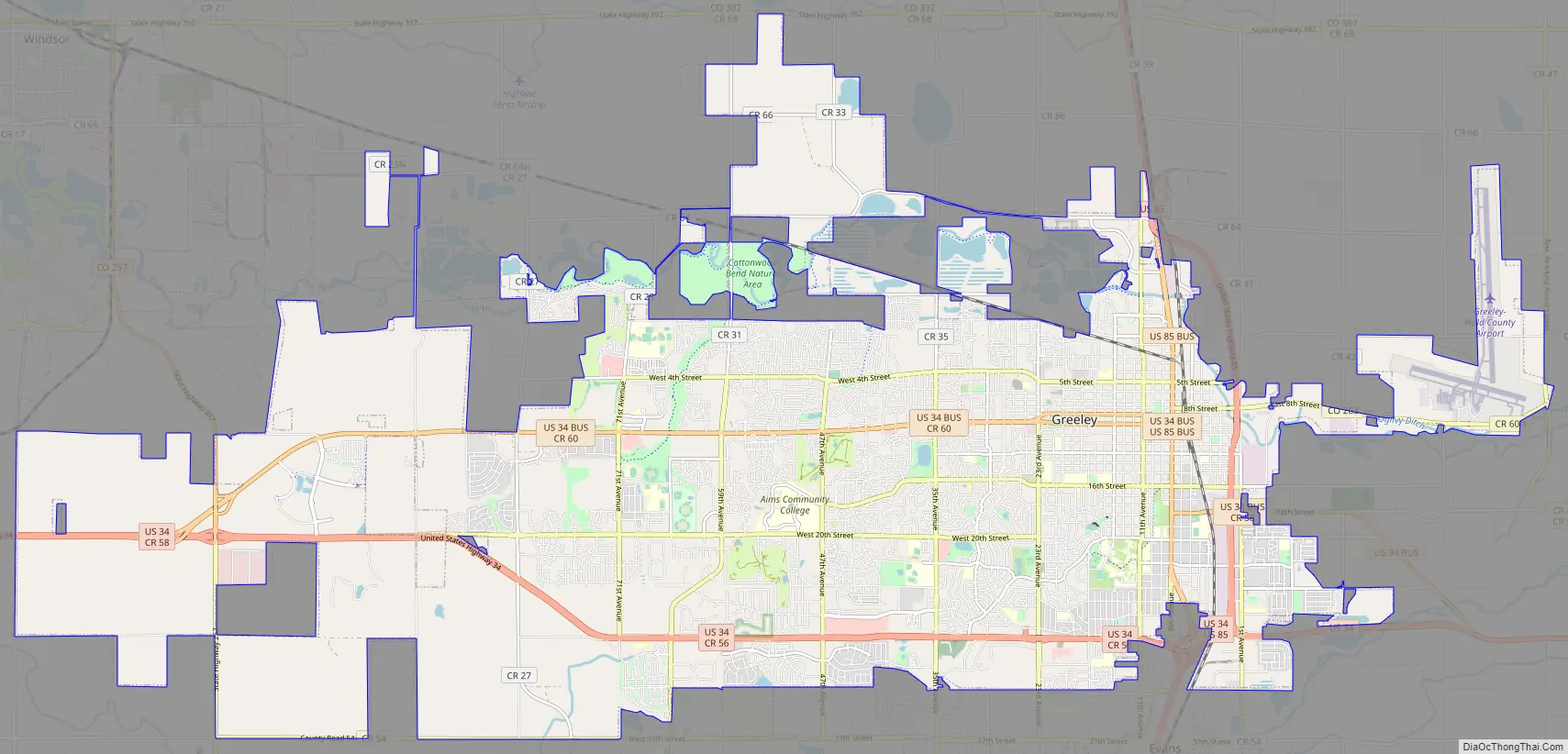
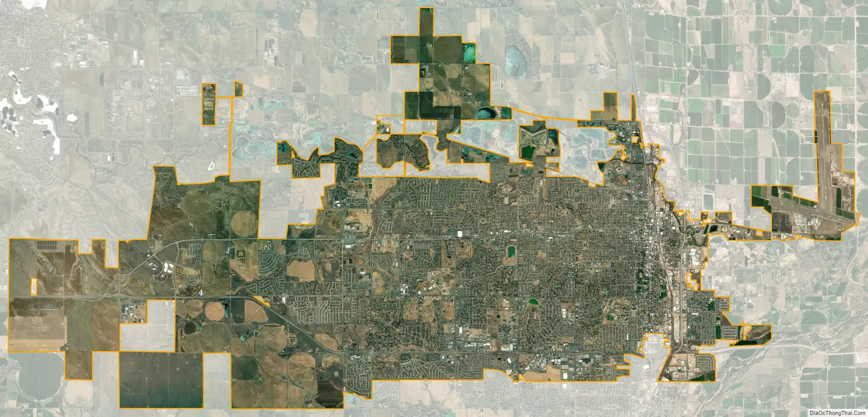
Greeley city Satellite Map
Geography
Greeley is located in the High Plains of northern Colorado about 25 mi (40 km) east of the Rocky Mountains and north of Denver.
Greeley is bordered on the south by the towns of Evans and Garden City. The Greeley/Evans area is bounded on the south by the South Platte River, and the Cache la Poudre River flows through north Greeley. The city is served by US Route 85 and US Route 34.
At the 2020 United States Census, the city had a total area of 31,419 acres (127.148 km) including 102 acres (0.413 km) of water.
The nearest city with a population of over 100,000 is Fort Collins, in neighboring Larimer County.
Climate
Greeley experiences a semi-arid climate (Köppen BSk). High temperatures are generally around 90–95 °F (32 °C) in the summer and 40-45 °F (4 °C) in the winter, although significant variation occurs. The hottest days generally occur around the third week of July and the coldest in January. Nighttime lows are near 60 °F (16 °C) in the summer and around 15–20 °F (−9 °C) in the winter. Record high temperatures of 112 °F (44.4 °C) have been recorded, as have record low temperatures of –25 °F (–32 °C). The first freeze typically occurs around October 4 and the last around May 4. Extratropical cyclones which disrupt the weather for the eastern two-thirds of the US often originate in or near Colorado, which means Greeley does not experience many fully developed storm systems. Warm fronts, sleet, and freezing rain are practically nonexistent here. In addition, the city’s proximity to the Rocky Mountains and lower elevation, compared to the mountains west of the city, result in less precipitation and fewer thunderstorms. This is paradoxical, because adjacent areas (mostly farmland) experience between 7 and 9 hail days per year.
The climate in Greeley, as well as all of Colorado, is extremely dry. The Chinook winds coming off the mountains often raise temperatures to near 70 °F (21 °C) in January and February, and sometimes to near 90 °F (32 °C) in April. Greeley’s elevation and low year-round humidity means that nighttime low temperatures are practically never above 68 °F (20 °C), even in the hottest part of the summer. The diurnal temperature range is usually rather wide, with a 50-degree (Fahrenheit) difference between daytime highs and nighttime lows not uncommon, especially in the spring and fall. Rapid day-to-day and diurnal fluctuation in temperature is also common.
See also
Map of Colorado State and its subdivision:- Adams
- Alamosa
- Arapahoe
- Archuleta
- Baca
- Bent
- Boulder
- Broomfield
- Chaffee
- Cheyenne
- Clear Creek
- Conejos
- Costilla
- Crowley
- Custer
- Delta
- Denver
- Dolores
- Douglas
- Eagle
- El Paso
- Elbert
- Fremont
- Garfield
- Gilpin
- Grand
- Gunnison
- Hinsdale
- Huerfano
- Jackson
- Jefferson
- Kiowa
- Kit Carson
- La Plata
- Lake
- Larimer
- Las Animas
- Lincoln
- Logan
- Mesa
- Mineral
- Moffat
- Montezuma
- Montrose
- Morgan
- Otero
- Ouray
- Park
- Phillips
- Pitkin
- Prowers
- Pueblo
- Rio Blanco
- Rio Grande
- Routt
- Saguache
- San Juan
- San Miguel
- Sedgwick
- Summit
- Teller
- Washington
- Weld
- Yuma
- Alabama
- Alaska
- Arizona
- Arkansas
- California
- Colorado
- Connecticut
- Delaware
- District of Columbia
- Florida
- Georgia
- Hawaii
- Idaho
- Illinois
- Indiana
- Iowa
- Kansas
- Kentucky
- Louisiana
- Maine
- Maryland
- Massachusetts
- Michigan
- Minnesota
- Mississippi
- Missouri
- Montana
- Nebraska
- Nevada
- New Hampshire
- New Jersey
- New Mexico
- New York
- North Carolina
- North Dakota
- Ohio
- Oklahoma
- Oregon
- Pennsylvania
- Rhode Island
- South Carolina
- South Dakota
- Tennessee
- Texas
- Utah
- Vermont
- Virginia
- Washington
- West Virginia
- Wisconsin
- Wyoming