Fulton is a town in Liberty Township, Fulton County, Indiana, United States. The population was 333 at the 2010 census.
| Name: | Fulton town |
|---|---|
| LSAD Code: | 43 |
| LSAD Description: | town (suffix) |
| State: | Indiana |
| County: | Fulton County |
| Elevation: | 794 ft (242 m) |
| Total Area: | 0.19 sq mi (0.48 km²) |
| Land Area: | 0.19 sq mi (0.48 km²) |
| Water Area: | 0.00 sq mi (0.00 km²) |
| Total Population: | 303 |
| Population Density: | 1,629.03/sq mi (627.49/km²) |
| ZIP code: | 46931 |
| Area code: | 574 |
| FIPS code: | 1826152 |
| GNISfeature ID: | 0434896 |
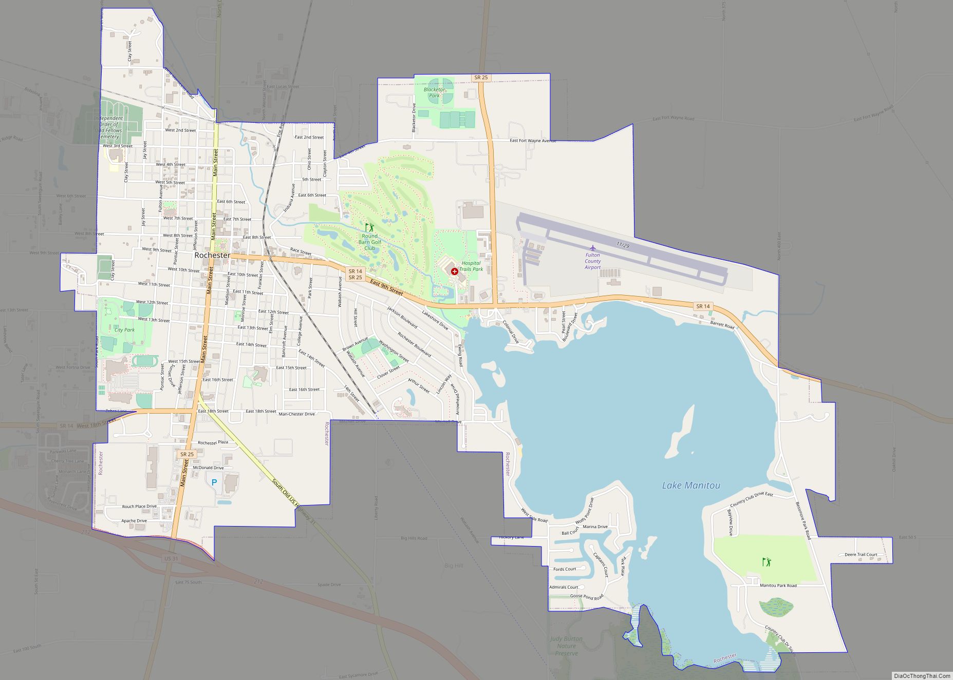
Online Interactive Map
Click on ![]() to view map in "full screen" mode.
to view map in "full screen" mode.
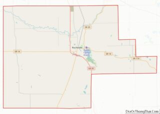
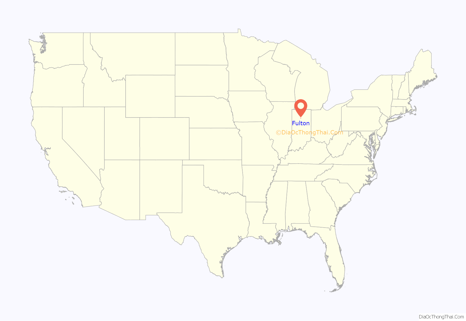
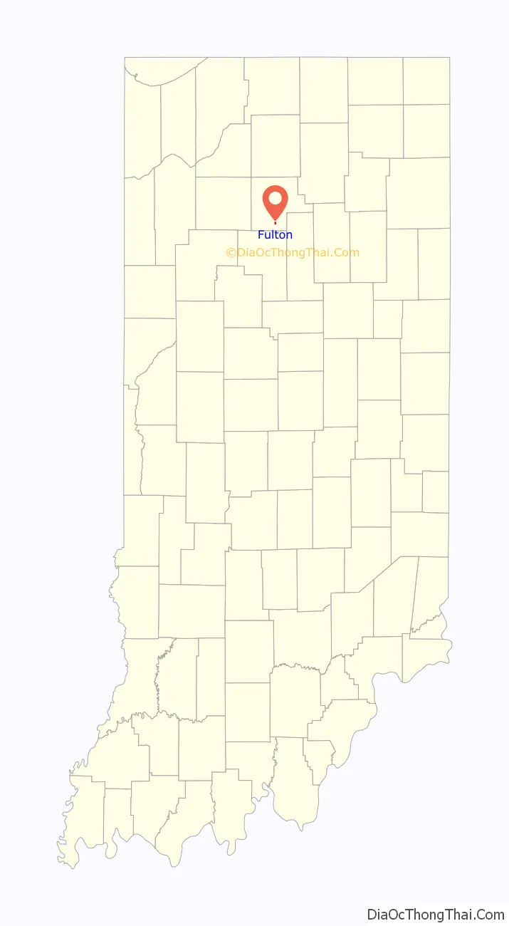
Fulton location map. Where is Fulton town?
History
Fulton took its name from Fulton County. The Fulton post office was established in 1843. In 1850 the first log cabin was erected in Fulton. Robert Aitken and family were the first occupants of the cabin and occupied a saw mill in the town. The village roads and markers were laid out in 1851 by Judge Wright of Logansport. The first schoolhouse was erected in 1845. In 1909 the first brick school was built. In 1852 the first church was erected by the Methodists. In late 1853 the Baptists also organized a church. Robert Aitken, the first settler, was appointed by the government as first postmaster in 1851. A tannery was established in 1851, and then a second tannery in 1853. Other additional businesses included a blacksmith shop, a grist mill, a carpet weaver, and an inn, erected in 1852 and eventually became a hotel. There was also a wood shop and other small businesses. The town’s first doctor, Franklin C. Dielman, came to town after his graduation from medical school. The first child delivered by Dr. Dielman was Hiram Ford, the first baby girl was Kathleen Rannels Carrithers. Fulton’s first bank was opened in 1907. The first newspaper, “The Fulton Leader” was established in 1901. A library was organized in 1920 and became a part of the Fulton County Library system in 1921. The Knights of Pythias was organized in 1905; The Masonic Lodge in 1906, followed by the Eastern Star in 1912. Fulton’s first street lights were installed in the summer of 1916.
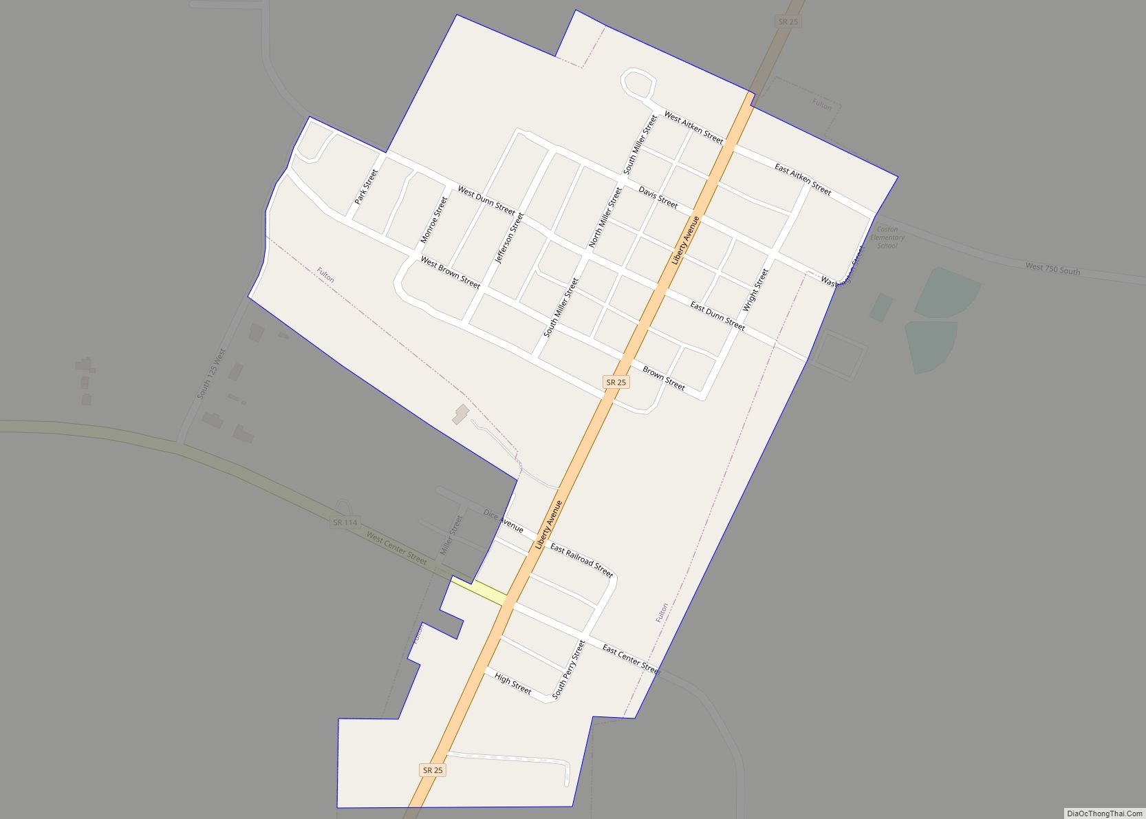
Fulton Road Map

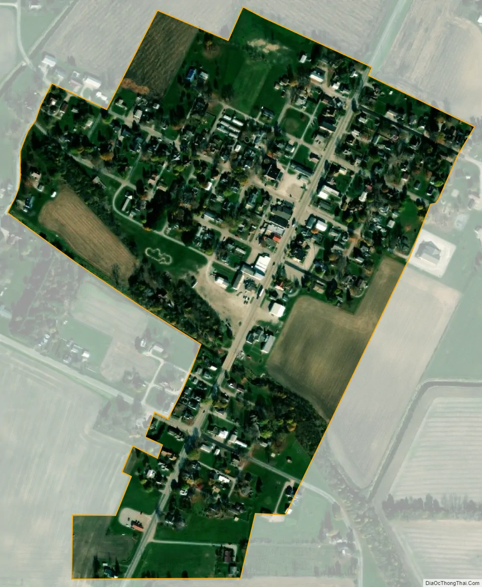
Fulton city Satellite Map
Geography
Fulton is located at 40°56′50″N 86°15′50″W / 40.94722°N 86.26389°W / 40.94722; -86.26389 (40.947157, -86.263935).
According to the 2010 census, Fulton has a total area of 0.18 square miles (0.47 km), all land.
See also
Map of Indiana State and its subdivision:- Adams
- Allen
- Bartholomew
- Benton
- Blackford
- Boone
- Brown
- Carroll
- Cass
- Clark
- Clay
- Clinton
- Crawford
- Daviess
- De Kalb
- Dearborn
- Decatur
- Delaware
- Dubois
- Elkhart
- Fayette
- Floyd
- Fountain
- Franklin
- Fulton
- Gibson
- Grant
- Greene
- Hamilton
- Hancock
- Harrison
- Hendricks
- Henry
- Howard
- Huntington
- Jackson
- Jasper
- Jay
- Jefferson
- Jennings
- Johnson
- Knox
- Kosciusko
- LaGrange
- Lake
- Lake Michigan
- LaPorte
- Lawrence
- Madison
- Marion
- Marshall
- Martin
- Miami
- Monroe
- Montgomery
- Morgan
- Newton
- Noble
- Ohio
- Orange
- Owen
- Parke
- Perry
- Pike
- Porter
- Posey
- Pulaski
- Putnam
- Randolph
- Ripley
- Rush
- Saint Joseph
- Scott
- Shelby
- Spencer
- Starke
- Steuben
- Sullivan
- Switzerland
- Tippecanoe
- Tipton
- Union
- Vanderburgh
- Vermillion
- Vigo
- Wabash
- Warren
- Warrick
- Washington
- Wayne
- Wells
- White
- Whitley
- Alabama
- Alaska
- Arizona
- Arkansas
- California
- Colorado
- Connecticut
- Delaware
- District of Columbia
- Florida
- Georgia
- Hawaii
- Idaho
- Illinois
- Indiana
- Iowa
- Kansas
- Kentucky
- Louisiana
- Maine
- Maryland
- Massachusetts
- Michigan
- Minnesota
- Mississippi
- Missouri
- Montana
- Nebraska
- Nevada
- New Hampshire
- New Jersey
- New Mexico
- New York
- North Carolina
- North Dakota
- Ohio
- Oklahoma
- Oregon
- Pennsylvania
- Rhode Island
- South Carolina
- South Dakota
- Tennessee
- Texas
- Utah
- Vermont
- Virginia
- Washington
- West Virginia
- Wisconsin
- Wyoming