Robbinsdale is a city in Hennepin County, Minnesota,. The population was 13,953 at the time of the 2010 census.
| Name: | Robbinsdale city |
|---|---|
| LSAD Code: | 25 |
| LSAD Description: | city (suffix) |
| State: | Minnesota |
| County: | Hennepin County |
| Founded: | 1893 |
| Elevation: | 873 ft (266 m) |
| Land Area: | 2.79 sq mi (7.24 km²) |
| Water Area: | 0.19 sq mi (0.50 km²) |
| Population Density: | 5,240.07/sq mi (2,023.25/km²) |
| ZIP code: | 55422 |
| Area code: | 763 |
| FIPS code: | 2754808 |
| GNISfeature ID: | 0650164 |
Online Interactive Map
Click on ![]() to view map in "full screen" mode.
to view map in "full screen" mode.
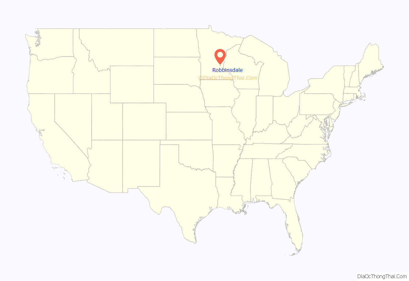
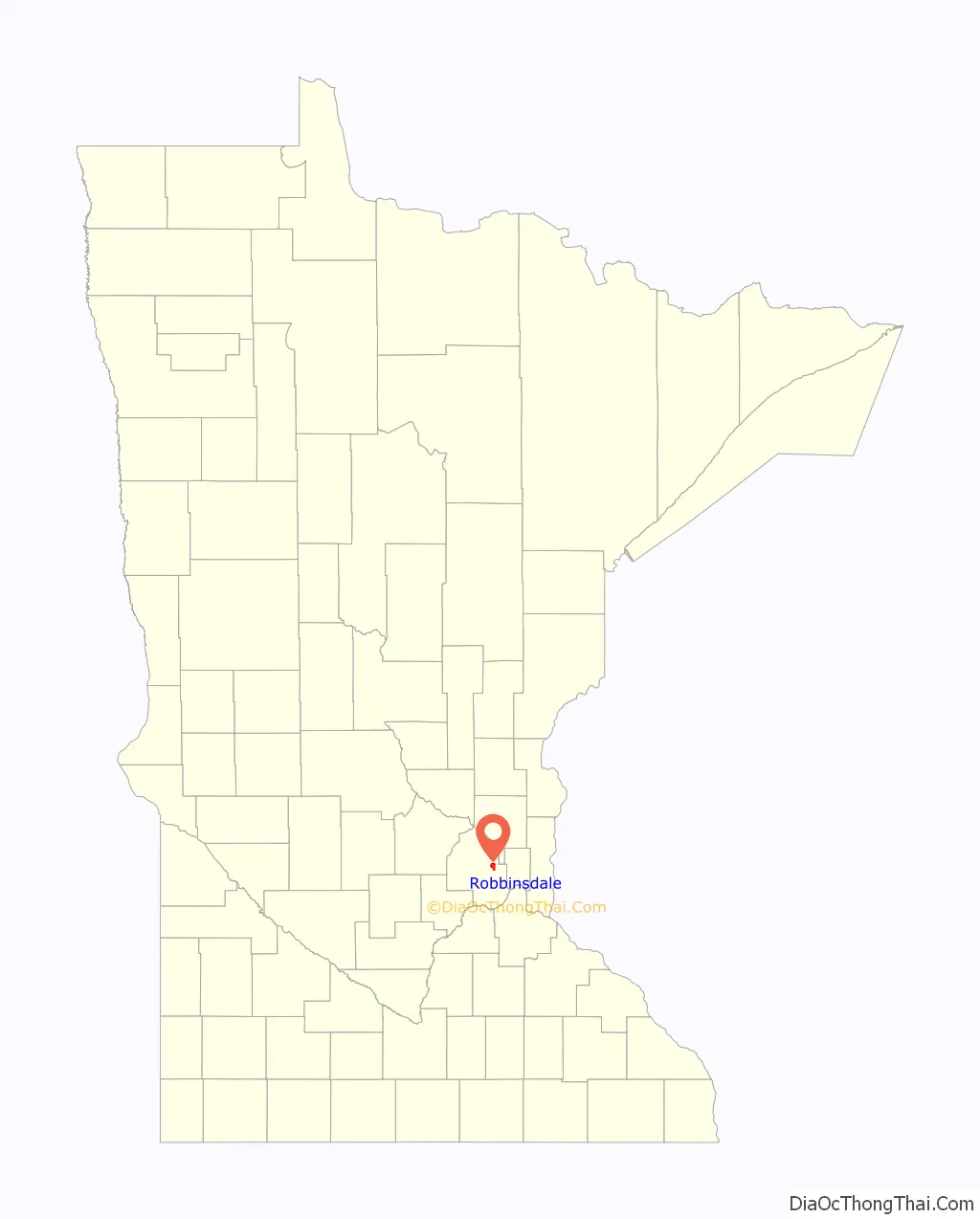
Robbinsdale location map. Where is Robbinsdale city?
History
Shortly after the Minnesota Territorial Legislative Assembly created Hennepin County in 1852, John C. Bohanon filed the first claim in the Township of Crystal Lake. Railroads didn’t reach the area until 1880. A flag station was established near the farm of Alfred Parker and six years later he donated land for a depot. The community that grew around it came to be known as Parker’s Station. In 1887 Minneapolis made an effort to secure more taxable property by annexing neighboring townships. In response, Crystal Lake farmers incorporated the Village of Crystal.
Later that year, entrepreneur, civil war veteran, and real estate developer, Andrew Bonney Robbins came to Parker’s Station on behalf of an Illinois business interest. Robbins was a former state senator and the brother-in-law of lumber baron, Thomas Barlow Walker. Robbins purchased 90 acres (360,000 m2) to the west of Lower Twin Lake to incorporate into the Robbinsdale Park subdivision. The summer of 1888 brought the first land boom. New industries moved in and a large Lutheran Seminary was built and Robbins began work on his Northern Car Company. The trolley manufacturing firm would eventually employ 150 people. In 1890 the Robbins built a 16-room Queen Anne-style mansion on Lower Twin Lake. After he moved his family in Robbins gathered investors and built the Hubbard Specialty Manufacturing Company. The firm made chairs and wheelbarrows. Despite his connections, Robbins was unable to persuade the Minneapolis Street Railway Company to extend a streetcar line up West Broadway. In 1891 he organized the North Side Street Railway Company and built his own line from the Minneapolis city limits to Robbinsdale Park. The street cars were pulled by horses until the line was converted to electricity. Robbins’ development efforts led to tension between farm families and residents near the village center. A special election was held and a vote to dissolve the Village of Crystal carried unanimously. On April 19, 1893, the new 2.9 square mile village of Robbinsdale was organized.
Fawcett Publications was founded in 1919 in Robbinsdale with the publication of Captain Billy’s Whiz Bang. In 1922 Fawcett introduced True Confessions magazine. The new publication, modeled on popular detective and romance pulps attracted a large female readership. In 1929 Fawcett launched Modern Mechanics. The magazine championed Yankee ingenuity and do it yourself projects. The first issue’s cover line was “Build your own airplane!”. Modern Mechanics was later renamed Mechanix Illustrated. Fawcett Publications eventually outgrew their offices in the Security State Bank Building on West Broadway. In 1930, the company relocated to the Sexton Building in downtown Minneapolis. The city’s pulp magazine history is echoed in Robbinsdale’s annual summer celebration, Whiz Bang Days.
In 1940 Dr. Samuel Samuelson built Victory Hospital on property he already owned in Robbinsdale. The original marble faced, three story building had five operating rooms and 70 beds. In 1954, Victory Hospital was reorganized as a non-profit and renamed North Memorial . Over the next 50 years North Memorial grew into 518 bed medical center. Today North Memorial Medical Center is a regional trauma center with eight helicopters, 120 ambulances, and 725 employees. North Memorial Medical Center. Besides being one of the state’s Level 1 Trauma Centers, it also operates AirCare, an air medical transport service. They have five flight bases around Minnesota.
In 1951, Sidney and William Volk hired the architectural firm of Liebenberg and Kaplan to the Terrace Theatre. Situated on a rise overlooking Crystal Lake and Bottineau Boulevard, the theater is considered by many to be a masterpiece of mid-century modern design. The building’s rectangular volumes originally contained a 1300-seat auditorium, an expansive lobby, sunken garden style lounge with a large copper fireplace, sweeping foyers and two snack bars.
The Terrace closed in 1999 and its out-of-state owner posted a “For Lease” sign but did not take care of the property. In May 2016 the City of Robbinsdale and State of Minnesota passed resolutions commemorating the Terrace as an important historic landmark. However, the city pursued demolition, giving rise to controversy between those who felt the theater was now a blighted property and others who wanted to reopen the Terrace as a point of community pride and a unique gathering place for music, film, and theater. A group of more than 2,000 supporters had petitioned the city to preserve and restore the theater, but area residents who wanted a nearby grocery store prevailed. After the city granted Tax Increment Financing to a developer to demolish the theater and the nearby mall and build a big box grocery store, a group of Terrace supporters filed a lawsuit to prevent demolition. The lawsuit was denied, and the theater was torn down in 2016 to be replaced by a 96,000 sq. ft. Hy-Vee grocery store.
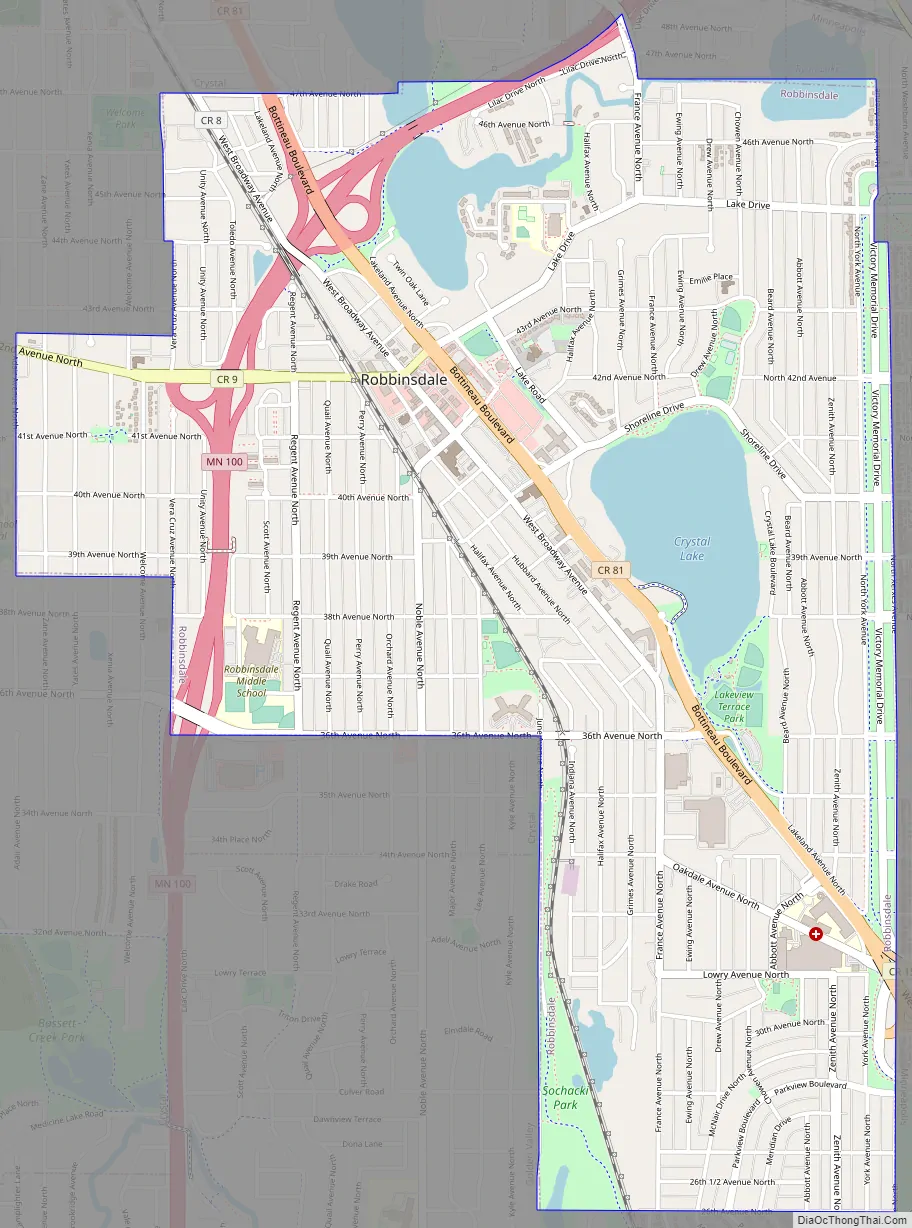
Robbinsdale Road Map
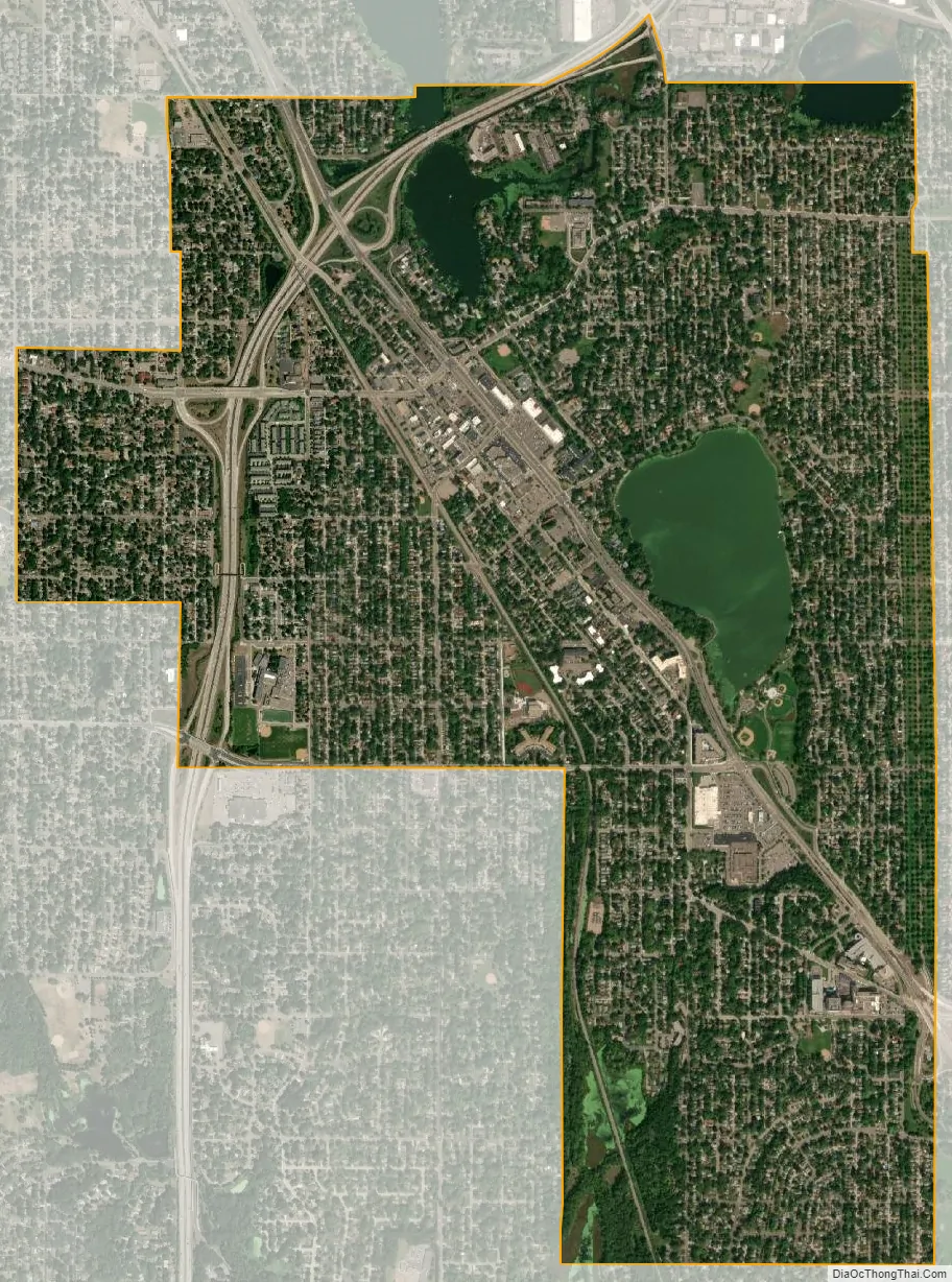
Robbinsdale city Satellite Map
Geography
According to the United States Census Bureau, the city has a total area of 2.98 square miles (7.72 km), of which 2.79 square miles (7.23 km) is land and 0.19 square miles (0.49 km) is water.
Minnesota State Highway 100 and County Road 81 are two of the main routes in the city.
See also
Map of Minnesota State and its subdivision:- Aitkin
- Anoka
- Becker
- Beltrami
- Benton
- Big Stone
- Blue Earth
- Brown
- Carlton
- Carver
- Cass
- Chippewa
- Chisago
- Clay
- Clearwater
- Cook
- Cottonwood
- Crow Wing
- Dakota
- Dodge
- Douglas
- Faribault
- Fillmore
- Freeborn
- Goodhue
- Grant
- Hennepin
- Houston
- Hubbard
- Isanti
- Itasca
- Jackson
- Kanabec
- Kandiyohi
- Kittson
- Koochiching
- Lac qui Parle
- Lake
- Lake of the Woods
- Lake Superior
- Le Sueur
- Lincoln
- Lyon
- Mahnomen
- Marshall
- Martin
- McLeod
- Meeker
- Mille Lacs
- Morrison
- Mower
- Murray
- Nicollet
- Nobles
- Norman
- Olmsted
- Otter Tail
- Pennington
- Pine
- Pipestone
- Polk
- Pope
- Ramsey
- Red Lake
- Redwood
- Renville
- Rice
- Rock
- Roseau
- Saint Louis
- Scott
- Sherburne
- Sibley
- Stearns
- Steele
- Stevens
- Swift
- Todd
- Traverse
- Wabasha
- Wadena
- Waseca
- Washington
- Watonwan
- Wilkin
- Winona
- Wright
- Yellow Medicine
- Alabama
- Alaska
- Arizona
- Arkansas
- California
- Colorado
- Connecticut
- Delaware
- District of Columbia
- Florida
- Georgia
- Hawaii
- Idaho
- Illinois
- Indiana
- Iowa
- Kansas
- Kentucky
- Louisiana
- Maine
- Maryland
- Massachusetts
- Michigan
- Minnesota
- Mississippi
- Missouri
- Montana
- Nebraska
- Nevada
- New Hampshire
- New Jersey
- New Mexico
- New York
- North Carolina
- North Dakota
- Ohio
- Oklahoma
- Oregon
- Pennsylvania
- Rhode Island
- South Carolina
- South Dakota
- Tennessee
- Texas
- Utah
- Vermont
- Virginia
- Washington
- West Virginia
- Wisconsin
- Wyoming


