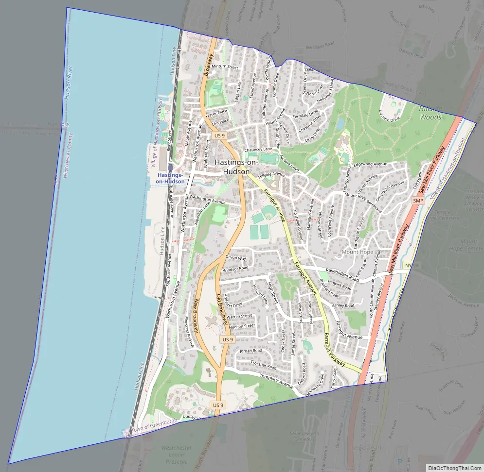
Hastings-on-Hudson is a village in Westchester County located in the southwestern part of the town of Greenburgh in the state of New York, United States. It is located on the eastern bank of the Hudson River, approximately 20 miles (32 km) north of midtown Manhattan in New York City, and is served by a stop on the Metro-North Hudson Line. To the north of Hastings-on-Hudson is the village of Dobbs Ferry, to the south, the city of Yonkers, and to the east unincorporated parts of Greenburgh. As of the 2020 US Census, it had a population of 8,590. The town lies on U.S. Route 9, “Broadway”, along with the Saw Mill River Parkway and I-287.
| Name: | Hastings-on-Hudson village |
|---|---|
| LSAD Code: | 47 |
| LSAD Description: | village (suffix) |
| State: | New York |
| County: | Westchester County |
| Total Area: | 2.92 sq mi (7.56 km²) |
| Land Area: | 1.98 sq mi (5.13 km²) |
| Water Area: | 0.94 sq mi (2.43 km²) |
| Total Population: | 8,590 |
| Population Density: | 4,340.58/sq mi (1,675.90/km²) |
| ZIP code: | 10706 |
| Area code: | 914 |
| FIPS code: | 3632710 |
| Website: | http://hastingsgov.org/ |
Online Interactive Map
Click on ![]() to view map in "full screen" mode.
to view map in "full screen" mode.
Hastings-on-Hudson location map. Where is Hastings-on-Hudson village?
History
The area that is now Hastings-on-Hudson and Dobbs Ferry was the primary settlement of the Weckquaesgeek Algonquian people, who called the community Wysquaqua. In the summer, the Weckquaesgeeks camped at the mouth of the ravine running under the present Warburton Avenue Bridge. There they fished, swam and collected oysters and clamshells used to make wampum. On the level plain nearby (which is now Maple Avenue), they planted corn and possibly tobacco.
The findings of large numbers of artifacts have suggested that there was significant tribal activity in the confluence of Factory Brook and Scheckler’s Brook just behind what is now the Cropsey Studio, but the interest in the site failed to generate any archeological inquiry.
Pre-1920
Around 1650, a Dutch carpenter, named Frederick Philipse, arrived in New Amsterdam. In 1682, Philipse traded with the Native Americans for the area that is now Dobbs Ferry and Hastings-on-Hudson. In 1693, the English Crown granted Philipse the Manor of Philipsburg, which included what is now Hastings-on-Hudson. After dividing the area into four nearly equal-sized farms, the Philipses leased them to Dutch, English and French Huguenot settlers.
During the American Revolution, what is now Hastings-on-Hudson, lay between the lines of the warring forces and was declared neutral territory. In reality, the area became a no-man’s land and was raided repeatedly by both sides. The minor Revolutionary War skirmish known as the Battle of Edgar’s Lane was fought in Hastings. Following the Revolution, the Philipses, who had been loyal to George III, saw their vast lands confiscated and sold by the newly established American state. In 1785, the four farms comprising today’s Hastings-on-Hudson were bought by James DeClark, Jacobus Dyckman, George Fisher, and tavern keeper Peter Post.
Around the same time, Westchester County, which had been established as one of the 10 original counties in New York, was divided into towns, and the area that is now Hastings-on-Hudson became part of the town of Greenburgh. The village was incorporated in 1879 and its name changed from Hastings-Upon-Hudson to Hastings-on-Hudson.
Stone quarrying was the earliest industry in Hastings-on-Hudson. From 1865 to 1871, hundreds of Scottish and Irish laborers blasted huge quantities of dolomitic marble from a white Westchester marble quarry. An inclined railroad carried the marble down to the quarry wharf where it was dressed by skilled stonecutters and loaded onto ships bound for cities like New York and Charleston, South Carolina.
By the 1880s, Hastings Pavement was producing hexagonal paving blocks which were used extensively in Central Park and Prospect Park in Brooklyn. Between 1895 and 1900, Hastings Pavement produced 10 million such blocks and shipped them throughout the United States and to cities in Canada, Brazil and England. By 1891, the National Conduit and Cable Company had established an operation on the waterfront producing cables for utility companies here and abroad. In 1912, labor strife between striking workers and their employer, the National Cable and Conduit Company, left two striking workers and two bystanders dead. Similar labor unrest occurred in 1916, whereby the Village was put under house arrest.
During World War I, 200 National Guardsmen were stationed in Hastings-on-Hudson because of the security interests of the National Conduit plant and a chemical plant opened by Frederick G. Zinsser that produced a wood alcohol called Hastings Spirits.
The plant was important because in 1915 it took orders from the UK to produce .303 ammunition but they could not pump up the production, so the contract were cancelled in late 1916. In 1917 it produced .30-06 ammo for the US Navy and Army.
1920-recent
The Anaconda Copper Company took over National Conduit in 1929, and a few years later acquired the Hastings Pavement property. By the end of World War II, Anaconda owned most of the industrial waterfront. Anaconda closed its Hastings-on-Hudson plant in 1975, bringing to an end the century-long era of heavy industry on the Hastings-on-Hudson waterfront.
The 1926-founded Hillside-on-Hastings sanitarium and hospital opened in 1926. They relocated to Glen Oaks, Queens in 1941.
Billie Burke, actress (the “Good Witch” in the Wizard of Oz) lived in Hastings-on-Hudson and left her property to the school district, which still owns it, and uses it for various sports.
Benjamin Franklin Goodrich, from Ripley, in western New York, used real estate profits to purchase the Hudson River Rubber Company, a small business in Hastings-on-Hudson. The following year, Goodrich relocated the business to Akron, Ohio.
Children’s Village, a boarding facility for children in difficult circumstances, located in neighboring Dobbs Ferry, sold about 50 acres (200,000 m) of its property in Hastings-on-Hudson to a developer in 1986. The developer was planning to build close to 100 homes that would result in traffic on the roads adjoining Hillside Elementary School. Local residents formed a committee called “Save Hillside Woods” and raised close to $800K. As a result of the 1987 stock market crash and the subsequent receivership of the bank that held the mortgage on the property, the Village purchased this parcel from the FDIC with the funds accumulated and a bond floated by the Village of Hastings-on-Hudson to expand and maintain Hillside Woods.
The Jasper F. Cropsey House and Studio and Hastings Prototype House are listed on the National Register of Historic Places. The John William Draper House is listed as a National Historic Landmark
Hastings-on-Hudson Road Map
Hastings-on-Hudson city Satellite Map
Geography
Hastings-on-Hudson is located at 40°59′28″N 73°52′27″W / 40.99111°N 73.87417°W / 40.99111; -73.87417 (40.991102, -73.874114) in an area of hills on the Hudson River opposite the Palisades cliffs, north of the city of Yonkers. The Village is bordered by the Hudson River to the west, and the Saw Mill River to the east. The areas facing the Hudson River have views of the Palisades to the west, Manhattan to the south and the Mario Cuomo Bridge to the north.
According to the United States Census Bureau, the Village has a total area of 2.9 square miles (7.5 km), of which 2.0 square miles (5.2 km) is land and 0.9 square miles (2.3 km), or 32.65%, is water.
Several small tributaries and headwaters of the Hudson River are located in the village, including Scheckler’s Brook which originates in Hillside Woods and Factory Brook which begins in a spring in the southern end of the Burke Estate, these merge behind the Cropsey Studio west of the Aqueduct Trail.
Transportation
Although a suburb of New York City, Hastings-on-Hudson enjoys better mass transit service than many other suburbs in the United States. Commuter rail service is available via the Hastings-on-Hudson railway station, served by the Metro-North Railroad’s Hudson Line to Grand Central Terminal, Croton-on-Hudson and Poughkeepsie; transfers to Amtrak’s Empire Corridor are available three stops south, at the Yonkers railway station. Additionally, several bus routes operated by the Bee-Line Bus System, connect Hastings-on-Hudson with other places in Westchester and northern sections of the Bronx.
The Saw Mill River Parkway has exits in Hastings-on Hudson – Northbound at Exit 12 at Farragut Parkway and Exit 13 at Farragut Avenue, and Southbound Exit 14 at Clarence Avenue and Exit 15 at Cliff Street. US Route 9 runs through the Village, as Broadway.
See also
Map of New York State and its subdivision:- Albany
- Allegany
- Bronx
- Broome
- Cattaraugus
- Cayuga
- Chautauqua
- Chemung
- Chenango
- Clinton
- Columbia
- Cortland
- Delaware
- Dutchess
- Erie
- Essex
- Franklin
- Fulton
- Genesee
- Greene
- Hamilton
- Herkimer
- Jefferson
- Kings
- Lake Ontario
- Lewis
- Livingston
- Madison
- Monroe
- Montgomery
- Nassau
- New York
- Niagara
- Oneida
- Onondaga
- Ontario
- Orange
- Orleans
- Oswego
- Otsego
- Putnam
- Queens
- Rensselaer
- Richmond
- Rockland
- Saint Lawrence
- Saratoga
- Schenectady
- Schoharie
- Schuyler
- Seneca
- Steuben
- Suffolk
- Sullivan
- Tioga
- Tompkins
- Ulster
- Warren
- Washington
- Wayne
- Westchester
- Wyoming
- Yates
- Alabama
- Alaska
- Arizona
- Arkansas
- California
- Colorado
- Connecticut
- Delaware
- District of Columbia
- Florida
- Georgia
- Hawaii
- Idaho
- Illinois
- Indiana
- Iowa
- Kansas
- Kentucky
- Louisiana
- Maine
- Maryland
- Massachusetts
- Michigan
- Minnesota
- Mississippi
- Missouri
- Montana
- Nebraska
- Nevada
- New Hampshire
- New Jersey
- New Mexico
- New York
- North Carolina
- North Dakota
- Ohio
- Oklahoma
- Oregon
- Pennsylvania
- Rhode Island
- South Carolina
- South Dakota
- Tennessee
- Texas
- Utah
- Vermont
- Virginia
- Washington
- West Virginia
- Wisconsin
- Wyoming


