| Name: | Philadelphia city |
|---|---|
| LSAD Code: | 25 |
| LSAD Description: | city (suffix) |
| State: | Pennsylvania |
| County: | Philadelphia County |
| Founded: | 1682 |
| Incorporated: | October 25, 1701 |
| Elevation: | 39 ft (12 m) |
| Land Area: | 134.36 sq mi (347.98 km²) |
| Water Area: | 8.34 sq mi (21.61 km²) |
| Population Density: | 11,936.92/sq mi (4,608.86/km²) |
| FIPS code: | 4260000 |
| GNISfeature ID: | 1215531 |
| Website: | www.phila.gov |
This Philadelphia map collection showcases the city’s highways, roads, places of interest, and things to do. From the Philadelphia Museum of Art to the Liberty Bell, you can explore the city and all its attractions with ease. We also feature an interactive map of Philadelphia for you to explore the city in more detail.
The City of Brotherly Love has something for everyone. From its historic sites to its vibrant culture and thriving arts scene, Philadelphia is a city that has something for everyone. Explore the city with this Philadelphia map collection and find out why it is one of the most beloved cities in America.
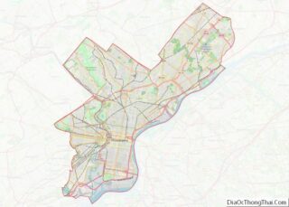
Online Interactive Map
Click on ![]() to view map in "full screen" mode.
to view map in "full screen" mode.
Philadelphia is an amazing city with loads of attractions and things to do. Explore this interactive map, and you can easily find the best restaurants, hotels, attractions, and more. Get the lay of the land, such as how the Delaware River outlines the eastern boundary of the city with the state of New Jersey. This interactive map will provide the best up-to-date map of Philly, and you can also explore it as a street map.
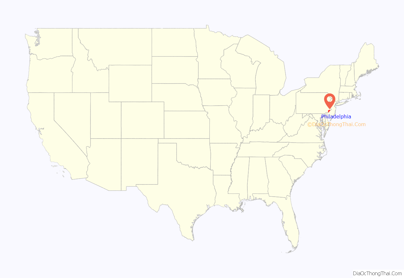
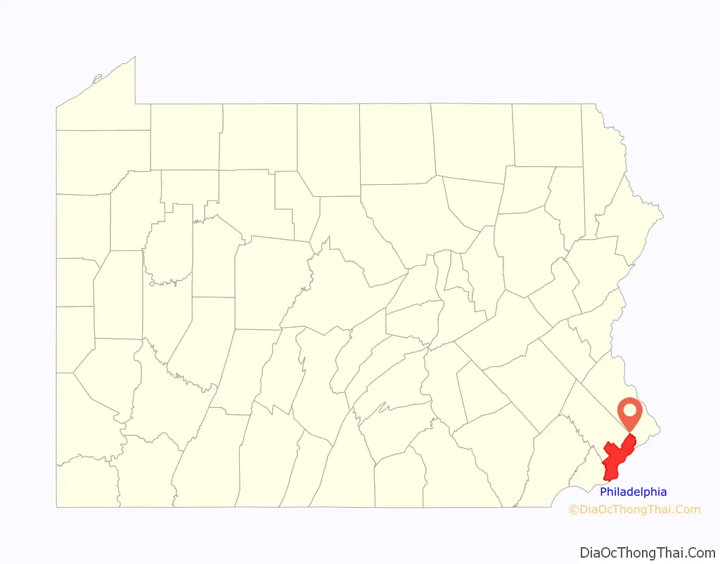
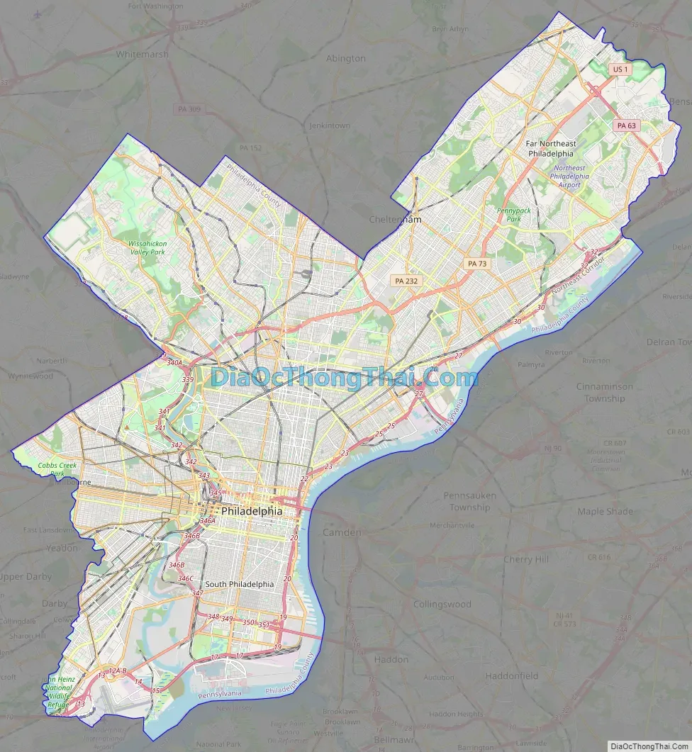
Philadelphia location map. Where is Philadelphia city?
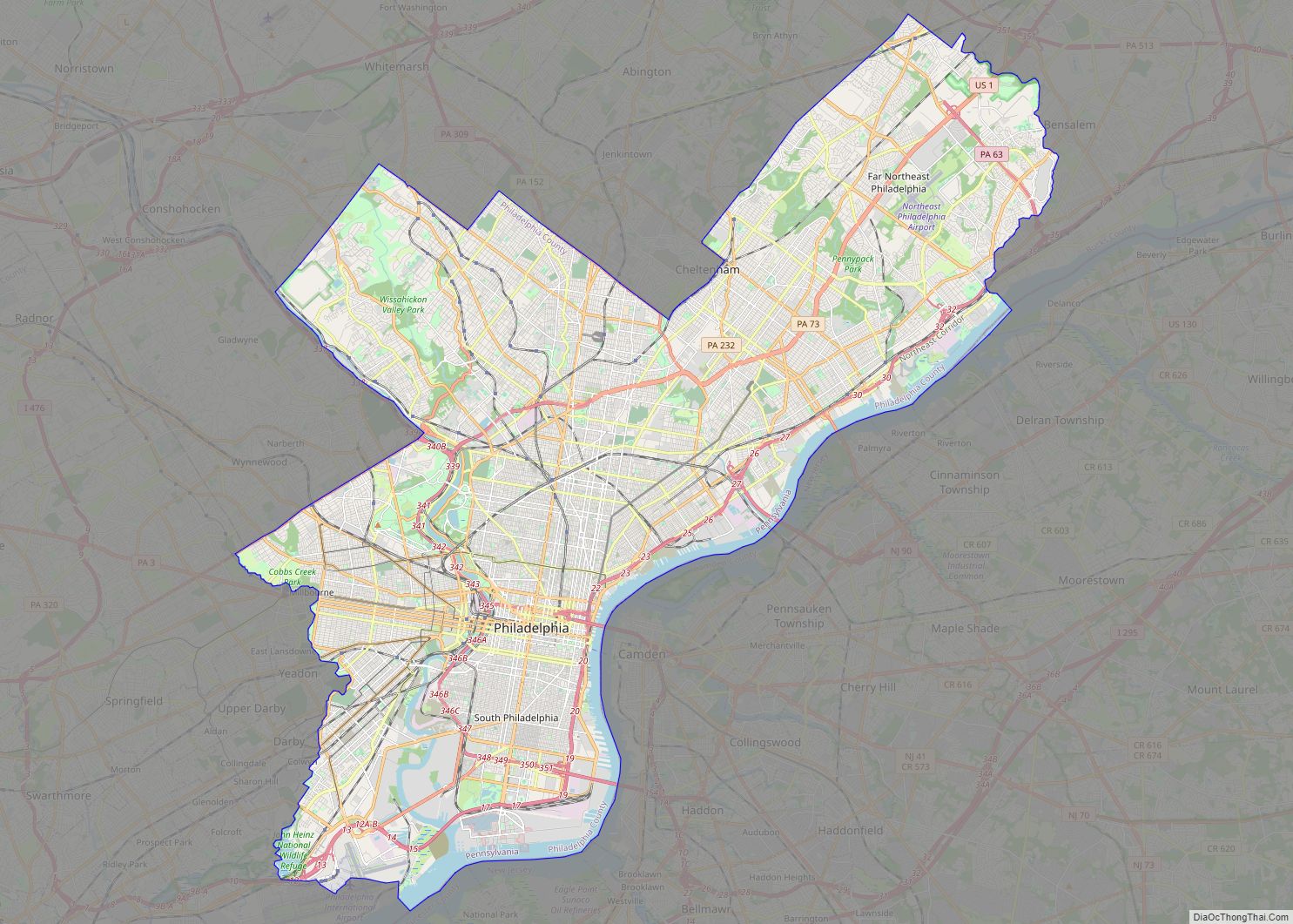
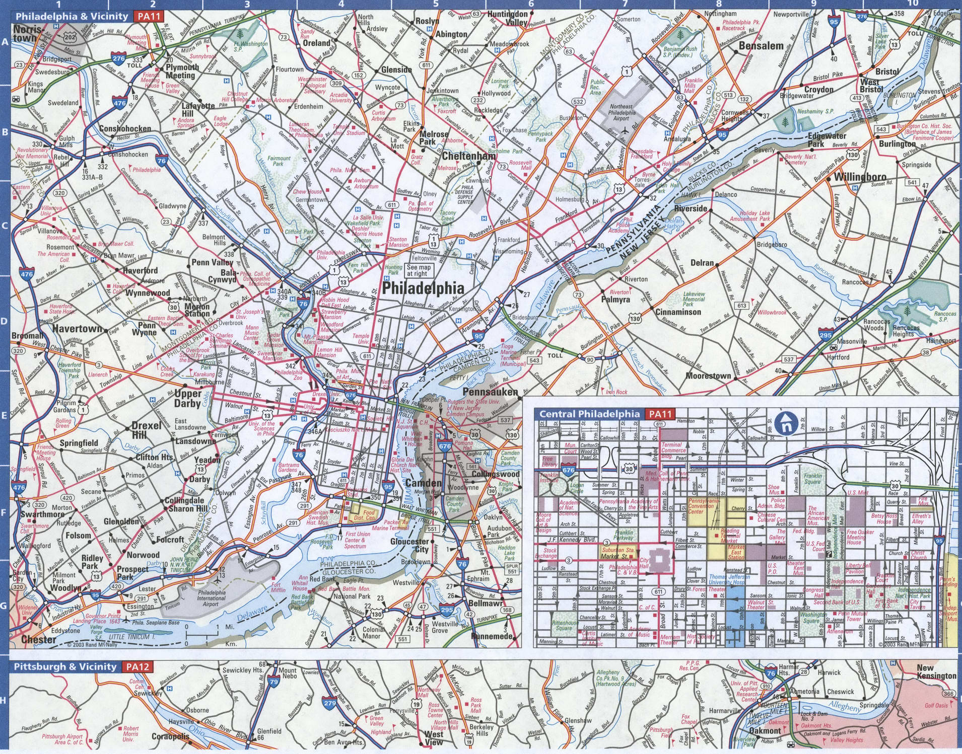
Philadelphia Road Map
Philadelphia is a big, beautiful city with a whole lot of history. Get your bearings with this road map and learn Philly like the locals. This map is the perfect travel companion to help you find your way around Philadelphia. Explore the area and all it has to offer including its interstates, highways, US highways, expressways/parkways, and major roads. Interstate Highways include I-76, I-95, and I-676. US Highways include 1, 3, 13, 30, 63, 73, 90, 291, 611, Bustleton Pike, Germantown Pike, Industrial Hwy, Lincoln Hwy, and Ridge Pike. Expressways/Parkways include Benjamin Franklin Pky, Cobbs Creek Pky, and Vine Street Expy. Major roads include 6th St, 15th St, 26th St, 30th St, 32nd St, 34th St, 38th St, 63rd St, Arch St, Baltimore Ave, Broad St, Cheltenham Ave, Chestnut St, City Ave, Cottman Ave, Girard Ave, John F Kennedy Blvd, Juniper St, Lancaster Ave, Market St, Old York Rd, Penn Sq, Penrose Ave, Pollock St, Roosevelt Blvd, University Ave, and Walnut St. Use this map as a navigation tool for the city, or plan a road trip around the state with our Pennsylvania road map.
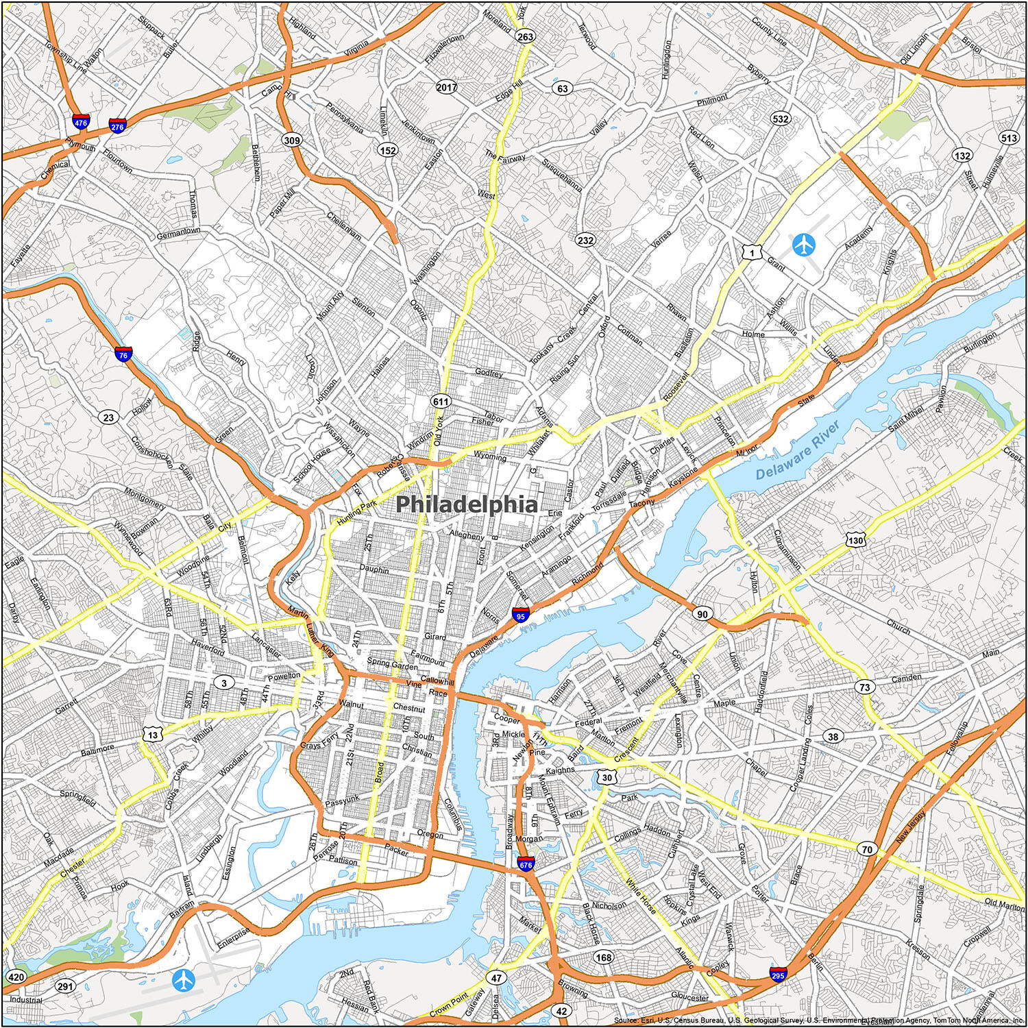
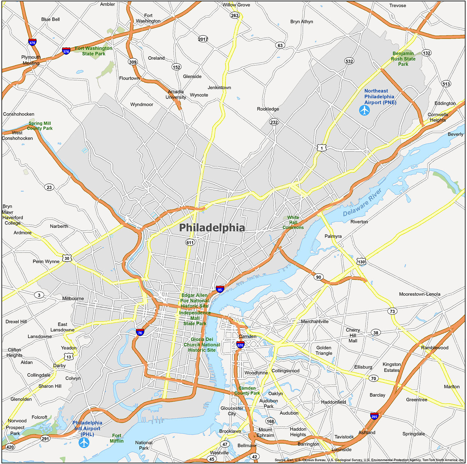
Discover the wonders of Philadelphia with our comprehensive reference map. Whether you’re a first-time visitor or a seasoned traveler, this map will guide you through the city’s history, culture, architecture, and transportation. Use it to explore neighborhoods, state parks, and points of interest. If you’re planning a trip to Philly, our reference map will serve as your go-to guide.
Airports: Philadelphia International Airport (PHL), Northeast Philadelphia Airport (PNE)
Cities: Beverly, Camden, Gloucester City, Philadelphia
Boroughs: Aldan, Ambler, Audubon, Audubon Park, Barrington, Bellmawr, Brooklawn, Bryn Athyn, Clifton Heights, Collingdale, Collingswood, Colwyn, Conshohocken, Darby, East Lansdowne, Folcroft, Glenolden, Haddon Heights, Haddonfield, Jenkintown, Lansdowne, Lawnside, Magnolia, Merchantville, Millbourne, Mount Ephraim, Narberth, National Park, Norwood, Oaklyn, Palmyra, Prospect Park, Riverton, Rockledge, Runnemede, Sharon Hill, Somerdale, Tavistock, West Conshohocken, Westville, Woodlynne, Yeadon
Census-designated place (CDP): Arcadia University, Ardmore, Ashland, Barclay, Blue Bell, Bryn Mawr, Cherry Hill Mall, Cornwells Heights, Drexel Hill, Echelon, Eddington, Ellisburg, Feasterville, Flourtown, Fort Washington, Glenside, Golden Triangle, Greentree, Haverford College, Kingston Estates, Marlton, Moorestown-Lenola, Oreland, Penn Wynne, Plymouth Meeting, Ramblewood, Springdale, Trevose, Willow Grove, Wyncote, Wyndmoor
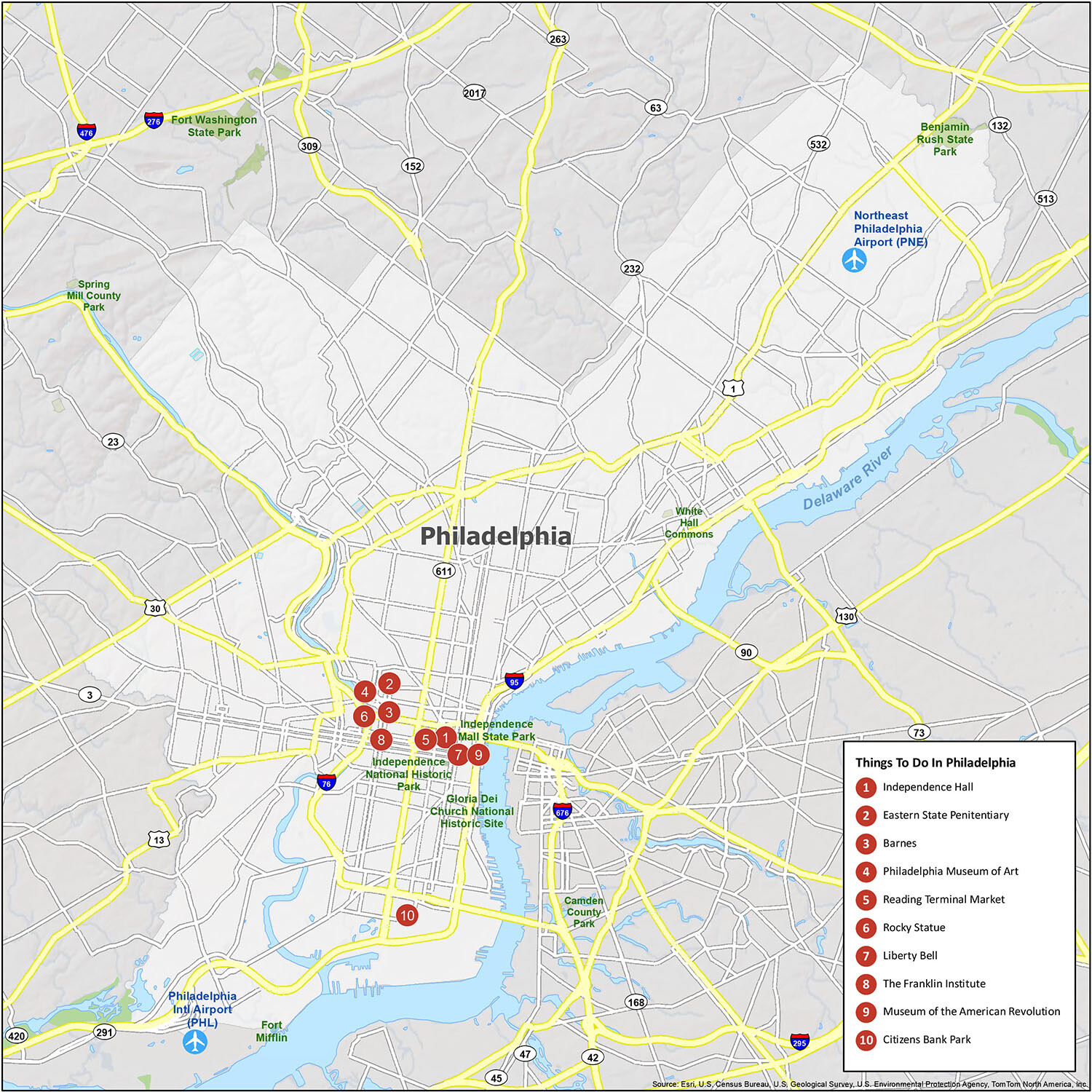
10 things to do in Philadelphia city
Philadelphia is an amazing city with loads of attractions and things to do. Explore this interactive map, and you can easily find the best restaurants, hotels, attractions, and more. Get the lay of the land, such as how the Delaware River outlines the eastern boundary of the city with the state of New Jersey. This interactive map will provide the best up-to-date map of Philly, and you can also explore it as a street map.
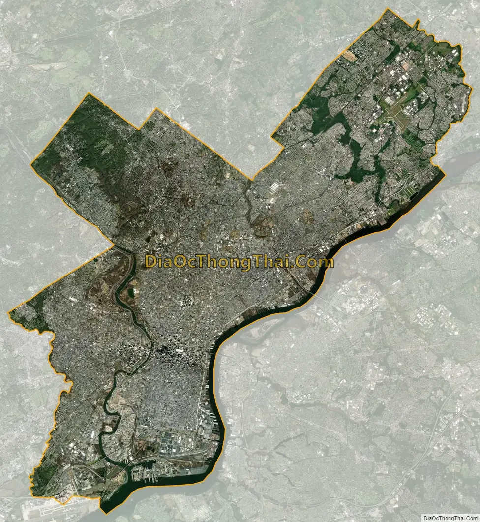
Philadelphia city Satellite Map
Geography
Topography
Philadelphia’s geographic center is about 40° 0′ 34″ north latitude and 75° 8′ 0″ west longitude. The 40th parallel north passes through neighborhoods in Northeast Philadelphia, North Philadelphia, and West Philadelphia including Fairmount Park. The city encompasses 142.71 square miles (369.62 km), of which 134.18 square miles (347.52 km) is land and 8.53 square miles (22.09 km), or 6%, is water. Natural bodies of water include the Delaware and Schuylkill rivers, lakes in Franklin Delano Roosevelt Park, and Cobbs, Wissahickon, and Pennypack creeks. The largest artificial body of water is East Park Reservoir in Fairmount Park.
The lowest point is sea level and the highest point is in Chestnut Hill about 446 feet (136 m) above sea level on Summit Street near the intersection of Germantown Avenue and Bethlehem Pike at: 40.07815 N, 75.20747 W. Philadelphia is located on the Atlantic Seaboard Fall Line that separates the Atlantic Plain from the Piedmont. The Schuylkill River’s rapids at East Falls were inundated by completion of the dam at Fairmount Water Works.
The city is the seat of its own county. The city is bordered by six adjacent counties: Montgomery to the northwest; Bucks to the north and northeast; Burlington County, New Jersey to the east; Camden County, New Jersey to the southeast; Gloucester County, New Jersey to the south; and Delaware County to the southwest.
Cityscape
Philadelphia was created in the 17th century following the plan by William Penn’s surveyor Thomas Holme. Center City is structured with long, straight streets running nearly due east–west and north–south, forming a grid pattern between the Delaware and Schuylkill rivers that is aligned with their courses. The original city plan was designed to allow for easy travel and to keep residences separated by open space that would help prevent the spread of fire. In keeping with the idea of a “Greene Countrie Towne”, and inspired by the many types of trees that grew in the region, Penn named many of the east–west streets for local trees. Penn planned the creation of five public parks in the city which were renamed in 1824 (new names in parentheses): Centre Square (Penn Square), Northeast Square (Franklin Square), Southeast Square (Washington Square), Southwest Square (Rittenhouse Square), and Northwest Square (Logan Circle/Square). Center City had an estimated 183,240 residents as of 2015, making it the second-most populated downtown area in the United States, after Midtown Manhattan in New York City.
Philadelphia’s neighborhoods are divided into six large sections that surround Center City: North Philadelphia, Northeast Philadelphia, South Philadelphia, Southwest Philadelphia, West Philadelphia, and Northwest Philadelphia. The city’s geographic boundaries have been largely unchanged since these neighborhoods were consolidated in 1854. However, each of these large areas contains numerous neighborhoods, some of whose boundaries derive from the boroughs, townships, and other communities that constituted Pennsylvania County before their inclusion within the city.
The City Planning Commission, tasked with guiding growth and development of the city, has divided the city into 18 planning districts as part of the Philadelphia2035 physical development plan. Much of the city’s 1980 zoning code was overhauled from 2007 to 2012 as part of a joint effort between former mayors John F. Street and Michael Nutter. The zoning changes were intended to rectify incorrect zoning maps to facilitate future community development, as the city forecasts an additional 100,000 residents and 40,000 jobs will be added by 2035.
The Philadelphia Housing Authority (PHA) is the largest landlord in Pennsylvania. Established in 1937, the PHA is the nation’s fourth-largest housing authority, serving about 81,000 people with affordable housing, while employing 1,400 on a budget of $371 million. The Philadelphia Parking Authority works to ensure adequate parking for city residents, businesses, and visitors.
Philadelphia’s architectural history dates back to colonial times and includes a wide range of styles. The earliest structures were constructed with logs, but brick structures were common by 1700. During the 18th century, the cityscape was dominated by Georgian architecture, including Independence Hall and Christ Church.
In the first decades of the 19th century, Federal and Greek Revival architecture were the dominant styles produced by Philadelphia architects such as Benjamin Latrobe, William Strickland, John Haviland, John Notman, Thomas Walter, and Samuel Sloan. Frank Furness is considered Philadelphia’s greatest architect of the second half of the 19th century. His contemporaries included John McArthur Jr., Addison Hutton, Wilson Eyre, the Wilson Brothers, and Horace Trumbauer. In 1871, construction began on the Second Empire-style Philadelphia City Hall. The Philadelphia Historical Commission was created in 1955 to preserve the cultural and architectural history of the city. The commission maintains the Philadelphia Register of Historic Places, adding historic buildings, structures, sites, objects and districts as it sees fit.
In 1932, Philadelphia became home to the first modern International Style skyscraper in the United States, the PSFS Building, designed by George Howe and William Lescaze. The 548 ft (167 m) City Hall remained the tallest building in the city until 1987 when One Liberty Place was completed. Numerous glass and granite skyscrapers were built in Center City beginning in the late 1980s. In 2007, the Comcast Center surpassed One Liberty Place to become the city’s tallest building. The Comcast Technology Center was completed in 2018, reaching a height of 1,121 ft (342 m), as the tallest building in the United States outside of Manhattan and Chicago.
For much of Philadelphia’s history, the typical home has been the row house. The row house was introduced to the United States via Philadelphia in the early 19th century and, for a time, row houses built elsewhere in the United States were known as “Philadelphia rows”. A variety of row houses are found throughout the city, from Federal-style continuous blocks in Old City and Society Hill to Victorian-style homes in North Philadelphia to twin row houses in West Philadelphia. While newer homes have been built recently, much of the housing dates to the 18th, 19th and early 20th centuries, which has created problems such as urban decay and vacant lots. Some neighborhoods, including Northern Liberties and Society Hill, have been rehabilitated through gentrification.
Elfreth’s Alley, “Our nation’s oldest residential street”, 1702–1836
Carpenters’ Hall exhibiting Georgian architecture, 1770–1774
Second Bank of the United States exhibiting Greek Revival architecture, 1818–1824
Second Empire-style Philadelphia City Hall, 1871–1901, from South Broad Street
The Art Deco-style grand concourse at 30th Street Station, 1927–1933
As of 2014, the city’s total park space, including municipal, state, and federal parks in the city, amounts to 11,211 acres (17.5 sq mi). Philadelphia’s largest park is Fairmount Park, which includes the Philadelphia Zoo and encompasses 2,052 acres (3.2 sq mi) of the total parkland. Fairmount Park’s adjacent Wissahickon Valley Park contains 2,042 acres (3.2 sq mi). Fairmount Park, when combined with Wissahickon Valley Park, is one of the largest contiguous urban park areas in the U.S. The two parks, along with the Colonial Revival, Georgian and Federal-style mansions in them, have been listed as one entity on the National Register of Historic Places since 1972.
Climate
According to the Köppen climate classification, Philadelphia falls under the northern periphery of the humid subtropical climate zone (Köppen Cfa), whereas according to the Trewartha climate classification, the city has a temperate maritime climate (Do) limited to the north by the continental climate (Dc). Summers are typically hot and muggy, fall and spring are generally mild, and winter is moderately cold. The plant life hardiness zones are 7a and 7b, representing an average annual extreme minimum temperature between 0 and 10 °F (−18 and −12 °C).
Snowfall is highly variable, with some winters experiencing only light snow, while others include major snowstorms. The normal seasonal snowfall averages 22.4 in (57 cm), with rare snowfalls in November or April, and rarely any sustained snow cover. Seasonal snowfall accumulation has ranged from trace amounts in 1972–73 to 78.7 inches (200 cm) in the winter of 2009–10. The city’s heaviest single-storm snowfall was 30.7 in (78 cm) which occurred in January 1996.
Precipitation is generally spread throughout the year, with eight to eleven wet days per month, at an average annual rate of 44.1 inches (1,120 mm), but historically ranging from 29.31 in (744 mm) in 1922 to 64.33 in (1,634 mm) in 2011. The most rain recorded in one day occurred on July 28, 2013, when 8.02 in (204 mm) fell at Philadelphia International Airport. Philadelphia has a moderately sunny climate with an average of 2,498 hours of sunshine annually, and a percentage of sunshine ranging from 47% in December to 61% in June, July, and August.
The January daily average temperature is 33.7 °F (0.9 °C), though the temperature frequently rises to 50 °F (10 °C) during thaws. July averages 78.7 °F (25.9 °C), although heat waves accompanied by high humidity and heat indices are frequent, with highs reaching or exceeding 90 °F (32 °C) on 30 days of the year. The average window for freezing temperatures is November 6 thru April 2, allowing a growing season of 217 days. Early fall and late winter are generally dry with February having the lowest average precipitation at 2.75 inches (70 mm). The dewpoint in the summer averages between 59.1 and 64.5 °F (15 and 18 °C).
The highest recorded temperature was 106 °F (41 °C) on August 7, 1918, but temperatures at or above 100 °F (38 °C) are not common, with the last occurrence of such a temperature was July 21, 2019. The lowest officially recorded temperature was −11 °F (−24 °C) on February 9, 1934. Temperatures at or below 0 °F (−18 °C) are rare with the last such occurrence being January 19, 1994. The record low maximum is 5 °F (−15 °C) on February 10, 1899, and December 30, 1880, while the record high minimum is 83 °F (28 °C) on July 23, 2011, and July 24, 2010.
Time Series
See or edit raw graph data.
Philadelphia County received an ozone grade of F and a 24-hour particle pollution rating of D in the American Lung Association’s 2017 State of the Air report, which analyzed data from 2013 to 2015. The city was ranked 22nd for ozone, 20th for short-term particle pollution, and 11th for year-round particle pollution. According to the same report, the city experienced a significant reduction in high ozone days since 2001—from nearly 50 days per year to fewer than 10—along with fewer days of high particle pollution since 2000—from about 19 days per year to about 3—and an approximate 30% reduction in annual levels of particle pollution since 2000. Five of the ten largest combined statistical areas (CSAs) were ranked higher for ozone: Los Angeles (1st), New York City (9th), Houston (12th), Dallas (13th), and San Jose, California (18th). Many smaller CSAs were also ranked higher for ozone including Sacramento (8th), Las Vegas (10th), Denver (11th), El Paso (16th), and Salt Lake City (20th); however, only two of those same ten CSAs—San Jose and Los Angeles—were ranked higher than Philadelphia for both year-round and short-term particle pollution.
See also
Map of Pennsylvania State and its subdivision:- Adams
- Allegheny
- Armstrong
- Beaver
- Bedford
- Berks
- Blair
- Bradford
- Bucks
- Butler
- Cambria
- Cameron
- Carbon
- Centre
- Chester
- Clarion
- Clearfield
- Clinton
- Columbia
- Crawford
- Cumberland
- Dauphin
- Delaware
- Elk
- Erie
- Fayette
- Forest
- Franklin
- Fulton
- Greene
- Huntingdon
- Indiana
- Jefferson
- Juniata
- Lackawanna
- Lancaster
- Lawrence
- Lebanon
- Lehigh
- Luzerne
- Lycoming
- Mc Kean
- Mercer
- Mifflin
- Monroe
- Montgomery
- Montour
- Northampton
- Northumberland
- Perry
- Philadelphia
- Pike
- Potter
- Schuylkill
- Snyder
- Somerset
- Sullivan
- Susquehanna
- Tioga
- Union
- Venango
- Warren
- Washington
- Wayne
- Westmoreland
- Wyoming
- York
- Alabama
- Alaska
- Arizona
- Arkansas
- California
- Colorado
- Connecticut
- Delaware
- District of Columbia
- Florida
- Georgia
- Hawaii
- Idaho
- Illinois
- Indiana
- Iowa
- Kansas
- Kentucky
- Louisiana
- Maine
- Maryland
- Massachusetts
- Michigan
- Minnesota
- Mississippi
- Missouri
- Montana
- Nebraska
- Nevada
- New Hampshire
- New Jersey
- New Mexico
- New York
- North Carolina
- North Dakota
- Ohio
- Oklahoma
- Oregon
- Pennsylvania
- Rhode Island
- South Carolina
- South Dakota
- Tennessee
- Texas
- Utah
- Vermont
- Virginia
- Washington
- West Virginia
- Wisconsin
- Wyoming