Shickshinny is a borough in Luzerne County, Pennsylvania, United States. The population was 630 at the 2020 census.
The borough is named after Shickshinny Creek, which runs through the municipality and the surrounding area. According to the book Indian Villages and Place Names in Pennsylvania (by Dr. George P. Donehoo), the community’s name likely means “Fine Stream” in a local Native American language. However, according to the Shickshinny Historical Society, the name Shickshinny means “Five Mountains” in a Native American language. Five mountains — Newport, Knob, Lee, River, and Rocky — encircle the creek and borough.
| Name: | Shickshinny borough |
|---|---|
| LSAD Code: | 21 |
| LSAD Description: | borough (suffix) |
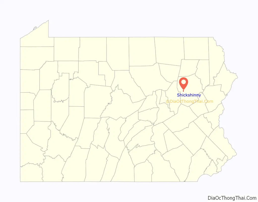
| State: | Pennsylvania |
| County: | Luzerne County |
| Incorporated: | 1861 |
| Elevation: | 512 ft (156 m) |
| Total Area: | 0.49 sq mi (1.27 km²) |
| Land Area: | 0.48 sq mi (1.23 km²) |
| Water Area: | 0.01 sq mi (0.03 km²) |
| Total Population: | 632 |
| Population Density: | 1,327.73/sq mi (512.14/km²) |
| ZIP code: | 18655 |
| Area code: | 570 |
| FIPS code: | 4270224 |
| Website: | www.shickshinny.org |
Online Interactive Map
Click on ![]() to view map in "full screen" mode.
to view map in "full screen" mode.
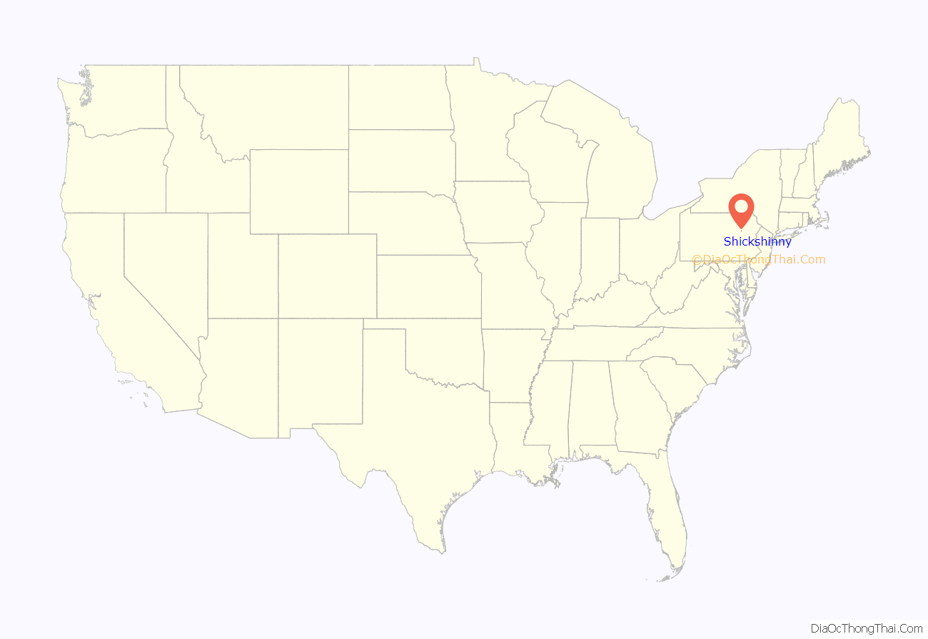
Shickshinny location map. Where is Shickshinny borough?
History
Early history
In 1782, the families of Austin and Crossley were the first white settlers in Shickshinny. The first permanent settler in the area was Lizzie James . At this time, Shickshinny was under the jurisdiction of Connecticut. In 1801, Shadrick Austin bought the 256 acres (104 ha) of land.
Another known settler in the area was William Koons (in the 1850s). Koons settled one mile outside of Shickshinny (where the Shickshinny Creek Bridge was later erected). The name of the area was changed to Koonsville (where the post office was later built). In 1773, Nathan Beach, also from Connecticut, settled outside of modern-day Shickshinny. The area was named Beach Haven after him.
A farm, which encompassed nearly the entire current-day borough, was established by Matthias Hollenback. By this time, it was under the Pennsylvania claim. The land was later inherited by his daughter, Cist Hollenback, who married Chester Butler. In 1857, upon C. Hollenbeck’s death, the land was divided and sold to the proprietors of the Shickshinny Company: George W. Search, Lot Search, Nathan Beach Crary, and Nathan Garrison. Walter Garrison bought the corner where the modern-day bank is located. Lot Search held the position of Luzerne County treasurer in 1855 and maintained it for two years.
N. Garrison and Andrew J. Eldon built the first store, located outside the old storehouse, in June 1857. But a few months after the store opened, Eldon fled to China with $3,000 of Garrison’s money. It was reported that Eldon was lost in a storm at sea and drowned from the weight of gold in his pockets. The business soon closed and was bought by Nathan B. Crary. A drug store opened at the same time. It was run and managed by Stephen Bond.
Borough
Shickshinny was incorporated as a borough on November 30, 1861. It gained its independence from Salem Township and Union Township, the majority (two-thirds) being from Union. The first officers were Burgess and Enke. The council was composed of Search, Koons, Crary, Nicely, and Davenport. G. W. Search became the secretary, while Slippy became supervisor. Second was Burgess, third Knor, fourth Youlls, fifth Bear, sixth Post, seventh Hughes, eighth Hartman, and ninth Bulkley.
Many businesses sprung up in the next decade, including a flour mill (set up by G. W. and Lot Search in 1865), a foundry (set up by Jesse Beadle, L. T. Hartman, and Frederick Beach in 1866), and a planing mill (set up by Amos Hess in 1874). Two blacksmith shops were also built and run by Miner Brown and Henry Wagner. The first newspaper in the area, The Mountain Echo, was first issued in 1873, established by C. A. Boone and M. E. Walker.
Shickshinny became a central hub for many farmers and businesses. A toll bridge was built in 1865 to Mocanaqua, the first of three up to 1920. An 1877 turnpike was built along the creek, heading towards Huntington Mills (modern-day Route 239).
Coal mining
Shickshinny is located at the lower end of the Wyoming Valley Coal Deposit, near a Red Ash vein that runs across the Susquehanna River.
Humphrey Davenport was employed in 1830 to prospect Nathan Beach’s land. He soon discovered coal on Rocky Mountain. For the next decade, coal was extracted from the mountain by teams of men. Finally in 1840, Beach’s grandson, Dr. Darwin Crary, invented the first inclined chute, which was used by the coal industry. It sent coal to the canal down the mountain. Two years later, in 1842, James A. Gordon built a plane for Beach and Crary. It ran for several successful years.
The mines were passed over to Truman H. Clark. In 1865, during the last year of the American Civil War, John M. Stackhouse and Matthew Wier purchased the mines. Cyrus Stackhouse bought out Wier’s stock the following year. Again, in 1869, the mines exchanged hands and were bought by the Paxton Coal Company. The Salem Coal Company was formed four years later. Under their guidance, the mines produced 65,000 tons and employed just short of 200 men and boys.
A nearby mountain — Newport — provided coal as well. It sits on the opposite side of the Susquehanna River and was found to possess superior coal. In 1857, roads and bridges were built to connect the Lackawanna and Bloomsburg Railroad, which lay on opposite sides of the river, so as to be able to mine Newport Mountain. Neither the Shickshinny nor Mocanaqua mines are in service today.
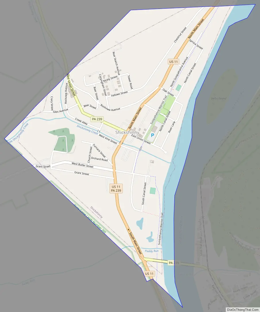
Shickshinny Road Map
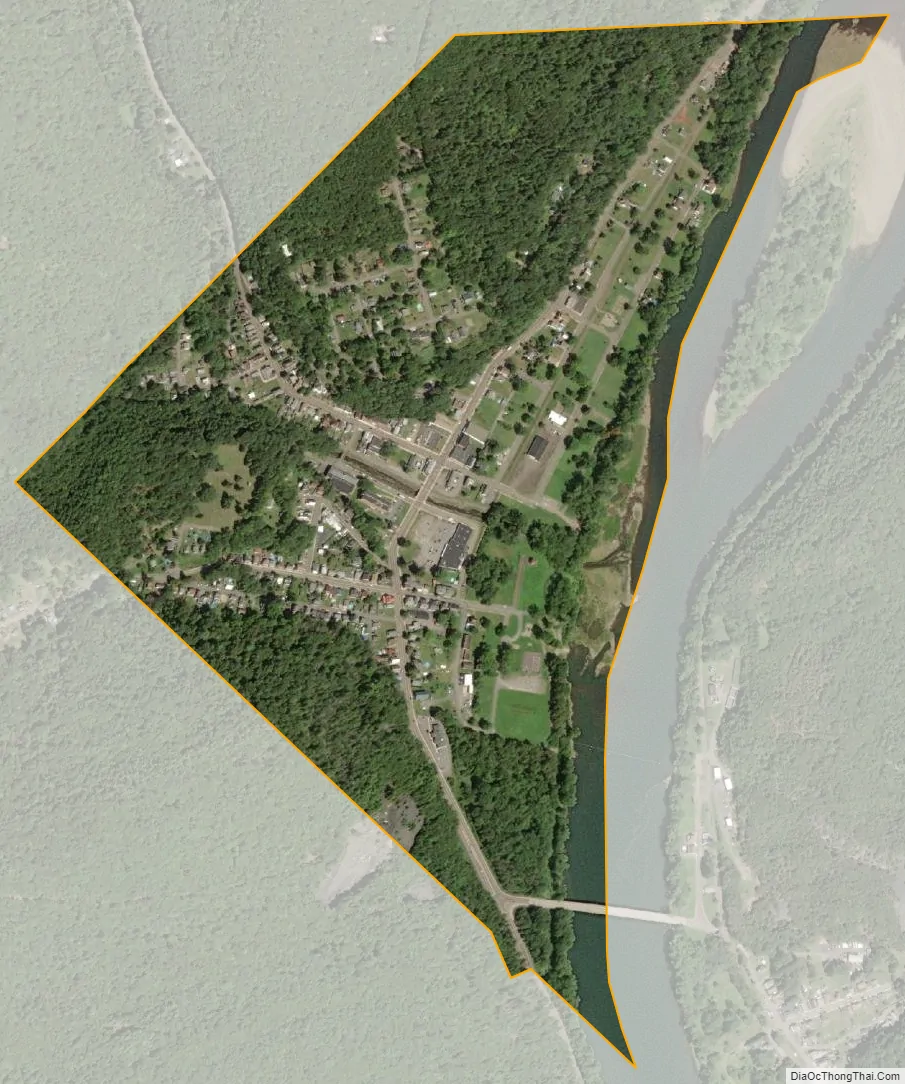
Shickshinny city Satellite Map
Geography
Shickshinny is located at 41°9′15″N 76°9′4″W / 41.15417°N 76.15111°W / 41.15417; -76.15111 (41.154044, -76.151182) along U.S. Route 11, midway between Nanticoke and Berwick. It is situated along the western bank of the Susquehanna River at the mouth of Shickshinny Creek. Little Shickshinny Creek, a tributary of Shickshinny Creek, meets Shickshinny Creek in the borough.
According to the United States Census Bureau, the borough has a total area of 0.50 square miles (1.3 km), of which 0.46 square miles (1.2 km) is land and 0.04 square miles (0.1 km), or 9.34%, is water. Shickshinny’s terrain is flat in the east; the elevation increases as you move westward. Shickshinny is made up of homes and businesses; the borough is surrounded by thick forests. The Susquehanna Warrior Trail passes through Shickshinny.
Major roads
US-11 runs through Shickshinny in a south-north direction. Pennsylvania Route 239 enters Shickshinny in the northwest. It exits the borough in the southeast and crosses over the Susquehanna River (in the direction of Mocanaqua).
Climate
The Köppen Climate Classification subtype for this climate is “Dfb” (Warm Summer Continental Climate).
Gallery
The PA 239 bridge linking Shickshinny to Mocanaqua
Shickshinny Creek
Presbyterian Church in Shickshinny
Houses in Shickshinny
Road in Shickshinny
See also
Map of Pennsylvania State and its subdivision:- Adams
- Allegheny
- Armstrong
- Beaver
- Bedford
- Berks
- Blair
- Bradford
- Bucks
- Butler
- Cambria
- Cameron
- Carbon
- Centre
- Chester
- Clarion
- Clearfield
- Clinton
- Columbia
- Crawford
- Cumberland
- Dauphin
- Delaware
- Elk
- Erie
- Fayette
- Forest
- Franklin
- Fulton
- Greene
- Huntingdon
- Indiana
- Jefferson
- Juniata
- Lackawanna
- Lancaster
- Lawrence
- Lebanon
- Lehigh
- Luzerne
- Lycoming
- Mc Kean
- Mercer
- Mifflin
- Monroe
- Montgomery
- Montour
- Northampton
- Northumberland
- Perry
- Philadelphia
- Pike
- Potter
- Schuylkill
- Snyder
- Somerset
- Sullivan
- Susquehanna
- Tioga
- Union
- Venango
- Warren
- Washington
- Wayne
- Westmoreland
- Wyoming
- York
- Alabama
- Alaska
- Arizona
- Arkansas
- California
- Colorado
- Connecticut
- Delaware
- District of Columbia
- Florida
- Georgia
- Hawaii
- Idaho
- Illinois
- Indiana
- Iowa
- Kansas
- Kentucky
- Louisiana
- Maine
- Maryland
- Massachusetts
- Michigan
- Minnesota
- Mississippi
- Missouri
- Montana
- Nebraska
- Nevada
- New Hampshire
- New Jersey
- New Mexico
- New York
- North Carolina
- North Dakota
- Ohio
- Oklahoma
- Oregon
- Pennsylvania
- Rhode Island
- South Carolina
- South Dakota
- Tennessee
- Texas
- Utah
- Vermont
- Virginia
- Washington
- West Virginia
- Wisconsin
- Wyoming


