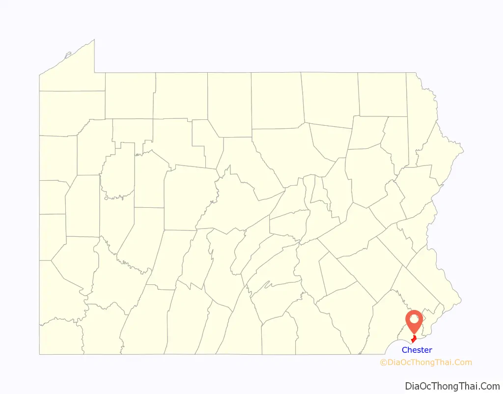
Chester is a city in Delaware County, Pennsylvania, United States. It is located in the Delaware Valley on the western bank of the Delaware River between Philadelphia and Wilmington, Delaware. The population of Chester was 32,605 at the 2020 census.
Incorporated in 1682, Chester is the oldest city in Pennsylvania and was the location of William Penn’s first arrival in the Province of Pennsylvania. It was the county seat for Chester County from 1682 to 1788 and of Delaware County from 1789 to 1851. Chester evolved over the centuries from a small town with wooden shipbuilding and textile factories into an industrial city producing steel ships for two World Wars and a myriad of consumer goods. Since the mid-twentieth century, it has lost its manufacturing base and over half of its residents and devolved into a post-industrial city struggling with pollution, poverty, and crime.
| Name: | Chester city |
|---|---|
| LSAD Code: | 25 |
| LSAD Description: | city (suffix) |
| State: | Pennsylvania |
| County: | Delaware County |
| Founded: | 1682 |
| Elevation: | 69 ft (21 m) |
| Total Area: | 6.00 sq mi (15.55 km²) |
| Land Area: | 4.83 sq mi (12.52 km²) |
| Water Area: | 1.17 sq mi (3.04 km²) |
| Total Population: | 32,605 |
| Population Density: | 6,746.33/sq mi (2,604.57/km²) |
| ZIP code: | 19013 |
| FIPS code: | 4213208 |
| GNISfeature ID: | 1171694 |
| Website: | www.chestercity.com |
Online Interactive Map
Click on ![]() to view map in "full screen" mode.
to view map in "full screen" mode.
Chester location map. Where is Chester city?
History
Early history
The Indian tribe that owned the land where Chester now stands were the Okehockings, removed by order of William Penn in 1702 to other lands in Chester County. The original Indian name of Chester was Mecoponaca, which means “the stream along which large potatoes grow”.
The first European settlers in the area were members of the New Sweden colony. The settlement that became Chester was first called “Finlandia” (the Latin name for Finland) and then “Upland” after the Swedish province of Uppland. The New Sweden settlers built Fort Mecoponacka in 1641 to defend the settlement.
In 1644, the present site of Chester was a tobacco plantation operated by the New Sweden colonists.
By 1682, Upland was the most populous town of the new Province of Pennsylvania. On October 27, the ship Welcome arrived bearing William Penn on his first visit to the province. Penn renamed the settlement after the English city of Chester.
18th century
Chester County originally stretched from the Delaware River to the Susquehanna River from its founding in 1682 until 1729 when Lancaster County was formed from the western part. Chester served as the county seat for Chester County from 1682 to 1788. In 1724, the Chester Courthouse was built to support the legal needs of the county.
Chester played only a small role in the American Revolutionary War. Throughout 1776 and 1777, there were significant forces stationed in Chester and nearby Marcus Hook.
In April 1776, nearly 1,000 men were stationed in Chester under Colonel Samuel Miles in preparation for the defense of Philadelphia. However, Colonel Miles led the troops to New York City in July 1776 when it became clear that the British Fleet was threatening New York rather than Philadelphia.
In 1777, the Continental Army led by George Washington passed through Chester on the way to meet the British Army led by General Howe at the Battle of Brandywine. John Armstrong was ordered to take command of the militia stationed at Chester. The Continental Army fled back to Chester after defeat at the Battle of Brandywine. A portion of the British force occupied Chester as they chased the Continental Army fleeing to Philadelphia.
In 1788, the Chester County seat was moved from Chester to West Chester. In 1789, Delaware County was formed from the eastern part of Chester County, and Chester became the new county seat.
The borough of Chester was governed under the charter granted by Penn in 1701 until March 5, 1795, when it was incorporated by the Pennsylvania Assembly.
19th century
In the 1700s and 1800s, Chester was a hub for business due to easy access to the Delaware River for the transport of raw materials and finished goods by ship. By the mid-1800s, many textile mills and factories were built along Chester Creek including the Upland Mills by John Price Crozer and the Powhattan Mills by David Reese Esrey and Hugh Shaw.
During the War of 1812, a group of volunteers from Chester called the Mifflin Guards was raised and led by Dr. Samuel Anderson. The troops were sent to Fort DuPont to defend the Delaware River from the threatened attack of British Admiral George Cockburn but did not see any action.
In 1851, the Delaware County seat was moved from Chester to the borough of Media. On February 14, 1866, Chester was incorporated as a city and the first mayor elected was John Larkin, Jr.
In 1871, the Delaware River Iron Ship Building and Engine Works was opened by John Roach through the purchase of the Reaney, Son & Archbold shipyard. The first steel ships of the U.S. Navy were built at the Roach shipyard. For the first 15 years of operation, it was the largest and most productive shipyard in the United States. More tonnage of ships were built at the Roach shipyard than its next two competitors combined.
Roach built other businesses to supply materials for his shipbuilding including the Chester Rolling Mill in 1873 to supply metal hull plates and beams, the Chester Pipe and Tube Company in 1877 for the manufacture of iron pipes and boiler tubes, and the Standard Steel Casting Company in 1883 to supply steel ingots.
Roach built the Combination Steel and Iron Company in 1880 to supply steel rails and other products for businesses beyond the Roach shipyard. He lost control of the company after his shipbuilding enterprise entered receivership in 1885.
20th century
Chester was known as a freewheeling destination for vices such as drugs, alcohol, numbers rackets, gambling and prostitution. Chester was widely known as Greater Philadelphia’s “Saloon Town”. By 1914, Chester had more saloons than police officers; approximately 1 saloon per every 987 residents.
During and following World War I, Chester grew significantly as people migrated to the city for jobs, 63% of which were in manufacturing. Between 1910 and 1920, Chester’s population increased from 38,000 to 58,000 due to the influx of southern and eastern Europeans and southern U.S. blacks. The Sun Shipbuilding & Drydock Co. was opened in 1917 to build ships for the United States until its closure in 1990. The idled Roach shipyard was purchased in 1917 by W. Averell Harriman to build merchant ships during World War I, and renamed the Merchant Shipbuilding Corporation. The shipyard closed permanently in 1923.
Like many boomtowns, Chester was unprepared for the social changes that came along with rapid growth. As southern blacks migrated to Pennsylvania as part of the Great Migration, racial violence broke out, racially segregated neighborhoods expanded and economic discrimination emerged. A four-day race riot that resulted in seven deaths broke out in the city in July 1917, and the separation of blacks and whites in Chester’s neighborhoods and workplaces became more defined.
In 1927, the Ford Motor Company opened the Chester Assembly factory on the site of the previous Roach and Merchant shipyard and built cars there until its closure in 1961.
Chester experienced its second growth period during World War II. Manufacturing increased exponentially including companies such as Wetherill Steel and Boilermakers, Congoleum-Nairn, Aberfoyles Textiles, Scott Paper Company, Belmont Iron Works, American Steel Foundries, Crew Levick Oil, Crown Smelting, Fields Brick Company, Hetzel and Ford Motor Company. During World War II, the Sun Shipyard became the largest single shipyard in the world.
The increased labor needs brought a flood of new workers to the city. The wartime labor force for industries along the waterfront soared to 100,000.
Chester began losing its mainstay manufacturing jobs by the early 1960s. Ford Motor Company shuttered its Chester plant, American Viscose Corporation in nearby Marcus Hook closed, Baldwin Locomotive Works in nearby Eddystone was close to bankruptcy and Sun Shipyard employment had fallen from a high of 35,000 in 1945 to 4,000 in 1962. Chester’s precipitous drop in jobs in the late 20th and early 21st centuries caused the city’s population to diminish from over 66,000 in 1950 to under 34,000 in 2010.
In 1963 and 1964, the Chester school protests fought to end the de facto segregation that resulted in the racial categorization of Chester public schools, even after the landmark 1954 U.S. Supreme Court case Brown v. Board of Education. The racial unrest and civil rights protests were led by George Raymond of the NAACP and Stanley Branche of CFFN and made Chester one of the key battlegrounds of the civil rights movement.
In April 1964, a series of almost nightly protests brought chaos to Chester. Mayor James Gorbey issued “The Police Position to Preserve the Public Peace”, a 10-point statement promising an immediate return to law and order. The city deputized firemen and trash collectors to help handle demonstrators. The State of Pennsylvania deployed 50 state troopers to assist the 77-member Chester police force. The demonstrations were marked by violence and police brutality with Chester being dubbed the “Birmingham of the North” by civil rights activist James Farmer. Over 600 people were arrested over a two-month period of civil rights rallies, marches, pickets, boycotts, and sit-ins. National civil rights leaders such as Gloria Richardson, Malcolm X and Dick Gregory came to Chester in support of the demonstrations. Pennsylvania Governor William Scranton became involved in the negotiations and convinced the protestors to obey a court-ordered moratorium on demonstrations by agreeing to hold hearings on the de facto segregation of public schools in Chester.
The Pennsylvania Human Relations Committee determined that the Chester School Board had violated the law and the Chester School District was ordered to desegregate the city’s six predominantly African-American schools. The city appealed the ruling, which delayed implementation, but the schools were eventually desegregated.
In 1978, an intense fire broke out at Wade Dump, a rubber recycling facility and illegal industrial chemical dumping site. It burned out of control for several days. The burning chemicals caused multi-colored smoke and noxious fumes which injured 43 firemen and caused long-term health problems for the first responders to the fire. In 1981, the location was declared a Superfund cleanup site and remediation occurred throughout the 1980s. In 1989, the site was deemed safe and removed from the Superfund national priorities list. In 2004, the site was converted to a parking lot for Commodore Barry Bridge Park.
By the 1980s, Chester was a city bereft of industry. Many bottom-rung projects were initiated in Chester, including the Westinghouse trash incinerator, a sewage treatment plant, and a prison. Chester residents and politicians began pushing back against the placement of projects that increased concerns about pollution, noise, and trucks, such as a contaminated soil remediation facility, the trash incinerator, the DELCORA sewage waste treatment center and the Abbonizio recycling center.
In 1995, the state designated Chester as a financially distressed municipality.
21st century
Recent programs to foster investment into Chester include the Pennsylvania Keystone Opportunity Zone (KOZ) program, which incentivizes companies with state and local tax breaks to invest in KOZ-designated areas. The Wharf at Rivertown, a $60 million renovation of the Chester Waterside Station of the Philadelphia Electric Company, originally built in 1918, provides recreational and office space for businesses.
Harrah’s Casino and Racetrack began harness racing in September 2006 and opened its racino in January 2007. Subaru Park, home of the Major League Soccer Philadelphia Union franchise, opened in 2010.
Despite the recent investments into the community, Governor Tom Wolf declared a fiscal emergency for Chester in 2020 and the city declared bankruptcy in 2022.
National Register of Historic Places in Chester are: Delaware County National Bank, 1724 Chester Courthouse, Chester Waterside Station of the Philadelphia Electric Company, Old Main and Chemistry Building, Third Presbyterian Church, William Penn Landing Site, and the former Second Street Bridge.
Chester Road Map
Chester city Satellite Map
Geography
Chester borders on (clockwise from southwest to northeast) Trainer Borough, Upper Chichester Township, Chester Township, Upland Borough, Parkside Borough, Brookhaven Borough, Nether Providence Township, Ridley Township, and Eddystone Borough in Pennsylvania. Chester is bordered to the south by the Delaware River. The city has a total area of 6.0 square miles (15.6 km), 4.8 square miles (12.5 km) of which is land and 1.2 square miles (3.0 km) of which (19.42%) is water, according to the U.S. Census Bureau.
Chester Creek meets the Delaware River in Chester. Chester’s northeastern border is at Ridley Creek. The Port of Chester is located in Chester along the Delaware River.
Climate
Located at a low elevation between Philadelphia and Wilmington, Delaware, Chester experiences a humid subtropical climate (Cfa.) The hardiness zone is 7b. [1] Archived 2014-02-09 at the Wayback Machine
See also
Map of Pennsylvania State and its subdivision:- Adams
- Allegheny
- Armstrong
- Beaver
- Bedford
- Berks
- Blair
- Bradford
- Bucks
- Butler
- Cambria
- Cameron
- Carbon
- Centre
- Chester
- Clarion
- Clearfield
- Clinton
- Columbia
- Crawford
- Cumberland
- Dauphin
- Delaware
- Elk
- Erie
- Fayette
- Forest
- Franklin
- Fulton
- Greene
- Huntingdon
- Indiana
- Jefferson
- Juniata
- Lackawanna
- Lancaster
- Lawrence
- Lebanon
- Lehigh
- Luzerne
- Lycoming
- Mc Kean
- Mercer
- Mifflin
- Monroe
- Montgomery
- Montour
- Northampton
- Northumberland
- Perry
- Philadelphia
- Pike
- Potter
- Schuylkill
- Snyder
- Somerset
- Sullivan
- Susquehanna
- Tioga
- Union
- Venango
- Warren
- Washington
- Wayne
- Westmoreland
- Wyoming
- York
- Alabama
- Alaska
- Arizona
- Arkansas
- California
- Colorado
- Connecticut
- Delaware
- District of Columbia
- Florida
- Georgia
- Hawaii
- Idaho
- Illinois
- Indiana
- Iowa
- Kansas
- Kentucky
- Louisiana
- Maine
- Maryland
- Massachusetts
- Michigan
- Minnesota
- Mississippi
- Missouri
- Montana
- Nebraska
- Nevada
- New Hampshire
- New Jersey
- New Mexico
- New York
- North Carolina
- North Dakota
- Ohio
- Oklahoma
- Oregon
- Pennsylvania
- Rhode Island
- South Carolina
- South Dakota
- Tennessee
- Texas
- Utah
- Vermont
- Virginia
- Washington
- West Virginia
- Wisconsin
- Wyoming


