| Name: | Nashville-Davidson metropolitan government (balance) |
|---|---|
| LSAD Code: | 00 |
| LSAD Description: | 0 |
| State: | Tennessee |
| County: | Davidson County |
| FIPS code: | 4752006 |
Discover the vibrant city of Nashville with our interactive Nashville map. Featuring highways, roads, places, and major landmarks, this map will help you explore the city with ease. Nashville is located in central Tennessee and is the home of country music, earning it the nickname “Music City”. It’s one of the fastest-growing cities in the country and the most populous city in Tennessee, just higher than Memphis. With its vibrant music scene, delicious food, and stunning nature, Nashville is an excellent place to visit for everyone.
Online Interactive Map
Click on ![]() to view map in "full screen" mode.
to view map in "full screen" mode.
Use this Nashville Tennessee map as your guide to help you get around, find things to do, and plan your trip. This interactive map shows the best attractions, sights, and restaurants. Also, find everything from the best shopping in town and even the best nightlife. With this interactive map, you can explore Nashville and plan your journey to some of the most important landmarks. This tool is a must-have for all visitors to the city.
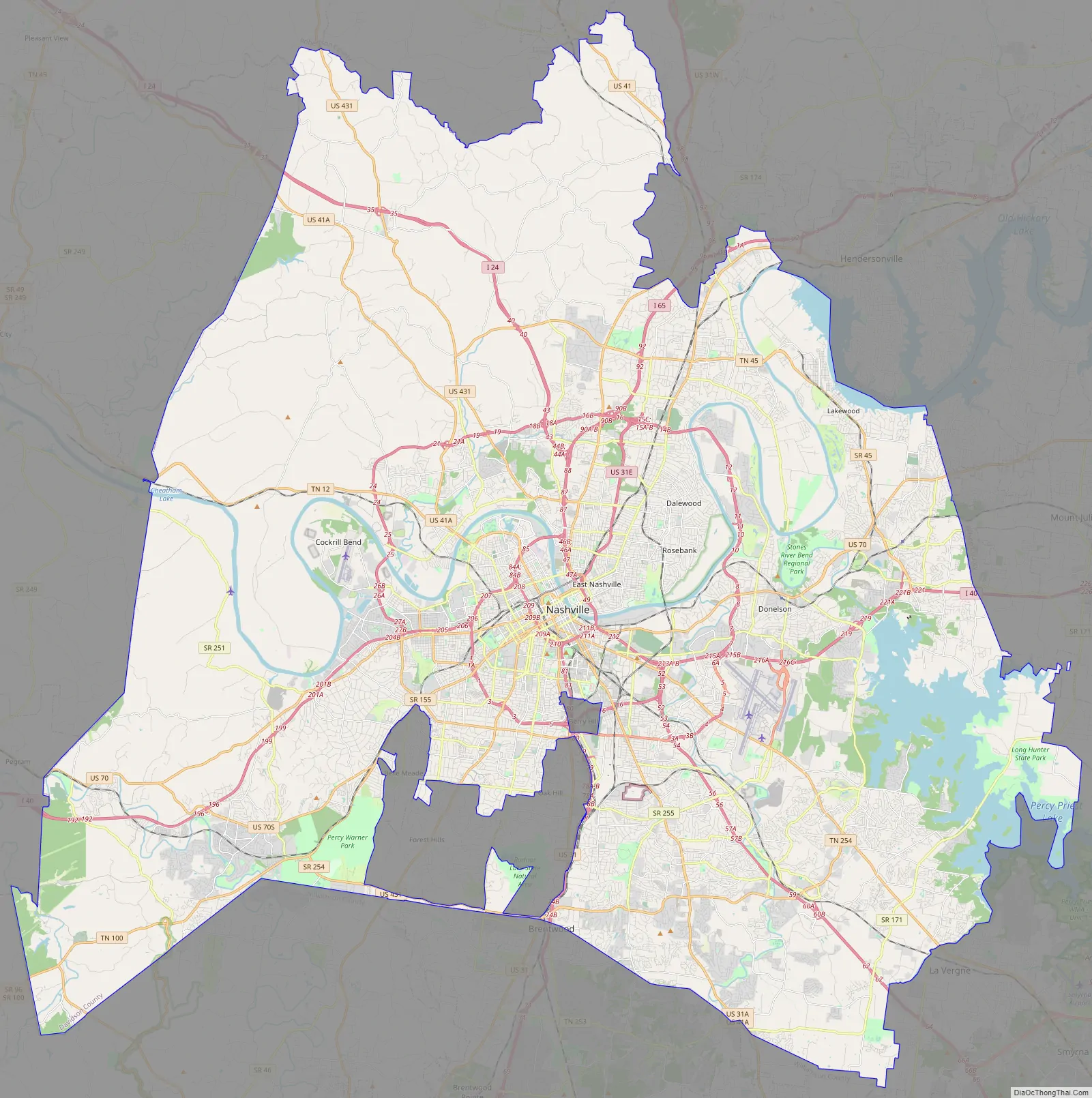
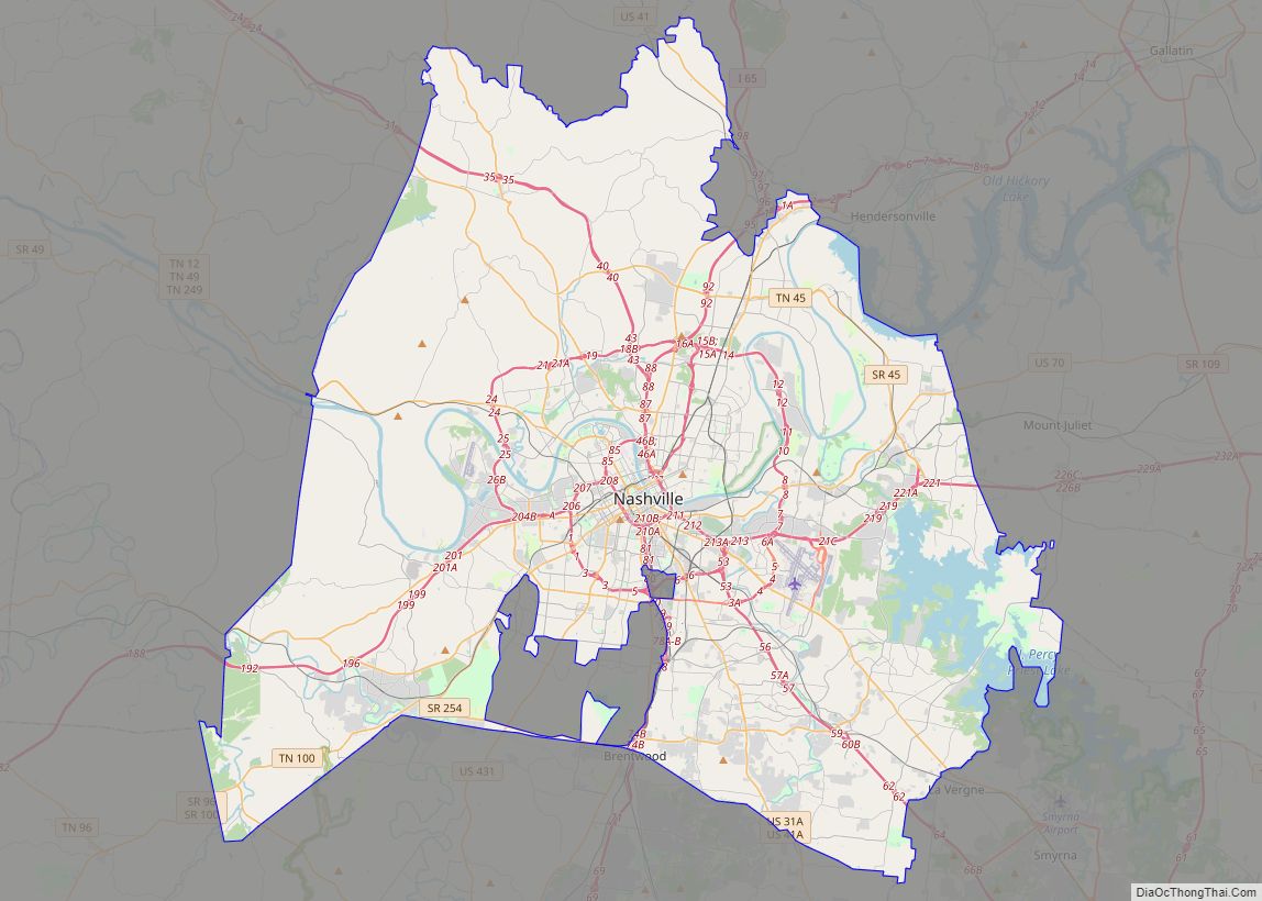
Nashville-Davidson metropolitan government (balance) location map. Where is Nashville-Davidson metropolitan government (balance)?
Nashville-Davidson metropolitan government (balance) Road Map
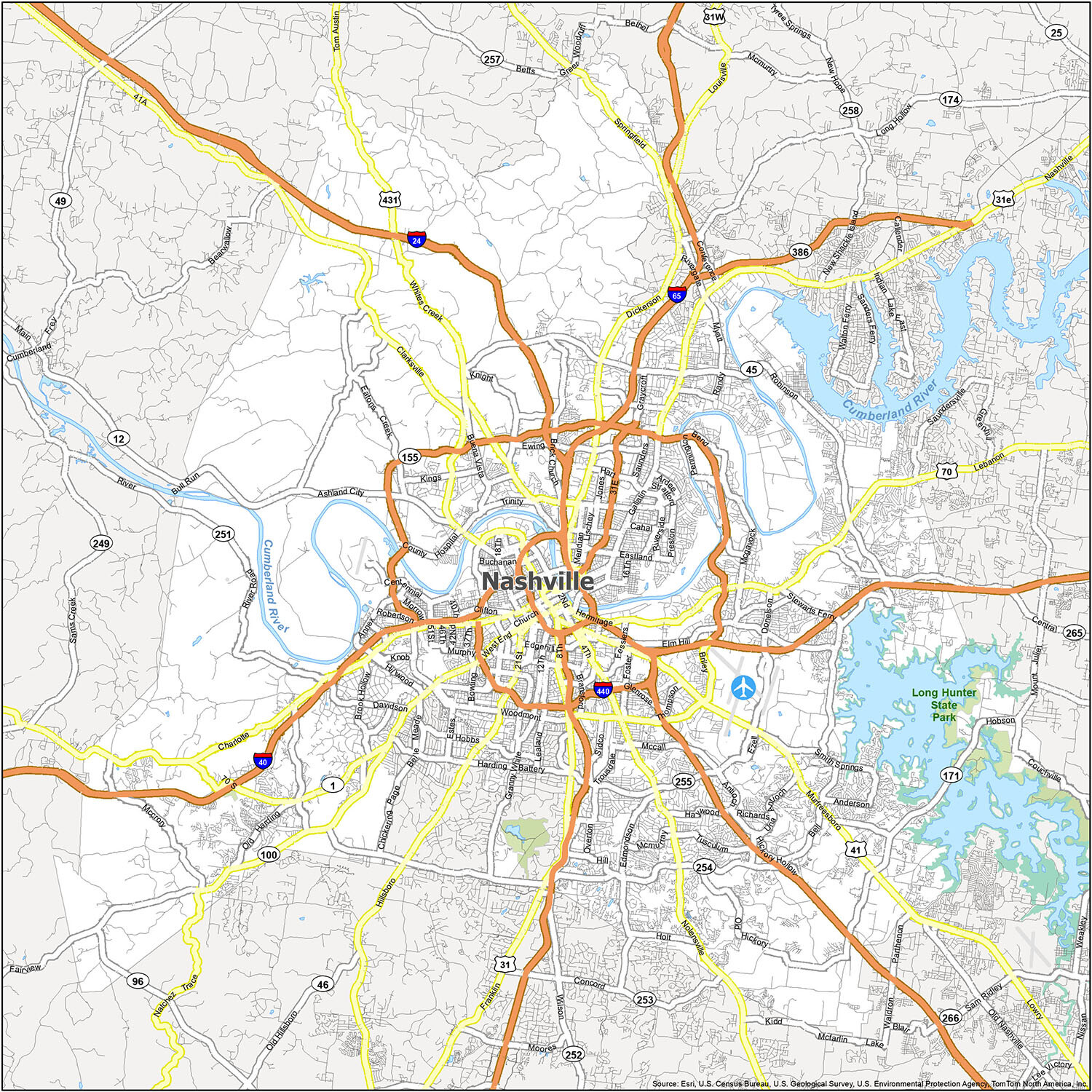
Don’t worry about getting lost or missing out on what the city has to offer. This Nashville road map covers all of Nashville, Tennessee, and is perfect for first-time visitors. It features detailed street labels of major roads and color-coded interstates and highways. Plus, all the major interstates, highways, and roads are conveniently located on this single printable map. But for any travel outside the city, refer to our Tennessee road map with interstates and highway information.
Interstate Highways: I-24, I-40, I-65, I-440
US Highways: 12, 31, 31E, 31W, 41, 45, 70, 96, 100, 155, 171, 254, 255, 265, 386, 431, Ashland City Hwy, Brick Church Pike, Charlotte Pike, Clarksville Hwy, Clarksville Pike, Dickerson Pike, Donelson Pike, Franklin Pike, Gallatin Pike, Harding Pike, Hillsboro Pike, Hobson Pike, Lebanon Pike, Murfreesboro Pike, Nolensville Pike, Springfield Hwy, Tom Austin Hwy, White Bridge Pike, Whites Creek Pike
Parkways: Briley Pky, Ellington Pky, James Robertson Pky, Natchez Trace Pky,
Major Roads: 1st Ave, 2nd Ave, 4th Ave, 8th Ave, 10th St, 14th Ave, 21st Ave, 46th Ave, 51st Ave, Alabama Ave, Baptist World Center Dr, Bell Rd, Broadway, Bull Run Rd, Central Pike, Charlotte Ave, Concord Rd, Conference Dr, Delaware Ave, Dickerson Rd, Ensley Blvd, Franklin Rd, Gallatin Ave, George L Davis Blvd, Grove Ave, Halls Ln, Harding Pl, Hermitage Ave, Hillsboro Rd, Jefferson St, Lafayette St, Lebanon Rd, Main St, Metrocenter Blvd, Murfreesboro Rd, Nolensville Rd, Old Hickory Blvd, Robinson Rd, Sidco Dr, Spring St, Terminal Dr, Thompson Ln, Trinity Ln, Wedgewood Ave, West End Ave, White Bridge Rd, Woodmont Blvd
Don’t let fear of getting lost stop you from exploring all that Nashville, Tennessee has to offer. This Nashville road map is perfect for first-time visitors, featuring detailed street labels of major roads and color-coded interstates and highways. Plus, all the major interstates, highways, and roads are conveniently located on this single printable map. For any travel outside the city, refer to our Tennessee road map with interstates and highway information.
Interstate Highways: I-24, I-40, I-65, I-440
US Highways: 12, 31, 31E, 31W, 41, 45, 70, 96, 100, 155, 171, 254, 255, 265, 386, 431, Ashland City Hwy, Brick Church Pike, Charlotte Pike, Clarksville Hwy, Clarksville Pike, Dickerson Pike, Donelson Pike, Franklin Pike, Gallatin Pike, Harding Pike, Hillsboro Pike, Hobson Pike, Lebanon Pike, Murfreesboro Pike, Nolensville Pike, Springfield Hwy, Tom Austin Hwy, White Bridge Pike, Whites Creek Pike
Parkways: Briley Pky, Ellington Pky, James Robertson Pky, Natchez Trace Pky,
Major Roads: 1st Ave, 2nd Ave, 4th Ave, 8th Ave, 10th St, 14th Ave, 21st Ave, 46th Ave, 51st Ave, Alabama Ave, Baptist World Center Dr, Bell Rd, Broadway, Bull Run Rd, Central Pike, Charlotte Ave, Concord Rd, Conference Dr, Delaware Ave, Dickerson Rd, Ensley Blvd, Franklin Rd, Gallatin Ave, George L Davis Blvd, Grove Ave, Halls Ln, Harding Pl, Hermitage Ave, Hillsboro Rd, Jefferson St, Lafayette St, Lebanon Rd, Main St, Metrocenter Blvd, Murfreesboro Rd, Nolensville Rd, Old Hickory Blvd, Robinson Rd, Sidco Dr, Spring St, Terminal Dr, Thompson Ln, Trinity Ln, Wedgewood Ave, West End Ave, White Bridge Rd, Woodmont Blvd
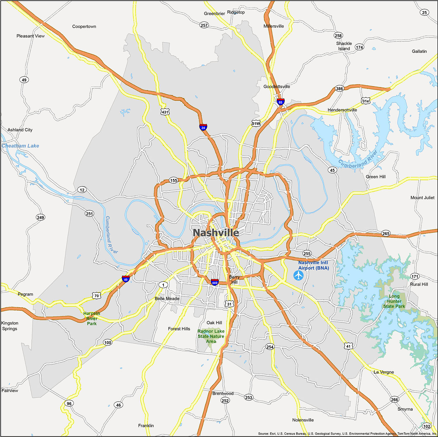
Discover the beauty of Nashville with a reference map! This map is the perfect way to explore the rivers, lakes, parks, and natural areas of Nashville. With its easy to follow layout, this map is sure to provide great details on the area. So don’t wait, explore Nashville and get the map today!
10 things to do in Nashville-Davidson metropolitan government (balance) city
Use this Nashville Tennessee map as your guide to help you get around, find things to do, and plan your trip. This interactive map shows the best attractions, sights, and restaurants. Also, find everything from the best shopping in town and even the best nightlife. With this interactive map, you can explore Nashville and plan your journey to some of the most important landmarks. This tool is a must-have for all visitors to the city.
Nashville-Davidson metropolitan government (balance) city Satellite Map
See also
Map of Tennessee State and its subdivision:- Anderson
- Bedford
- Benton
- Bledsoe
- Blount
- Bradley
- Campbell
- Cannon
- Carroll
- Carter
- Cheatham
- Chester
- Claiborne
- Clay
- Cocke
- Coffee
- Crockett
- Cumberland
- Davidson
- Decatur
- DeKalb
- Dickson
- Dyer
- Fayette
- Fentress
- Franklin
- Gibson
- Giles
- Grainger
- Greene
- Grundy
- Hamblen
- Hamilton
- Hancock
- Hardeman
- Hardin
- Hawkins
- Haywood
- Henderson
- Henry
- Hickman
- Houston
- Humphreys
- Jackson
- Jefferson
- Johnson
- Knox
- Lake
- Lauderdale
- Lawrence
- Lewis
- Lincoln
- Loudon
- Macon
- Madison
- Marion
- Marshall
- Maury
- McMinn
- McNairy
- Meigs
- Monroe
- Montgomery
- Moore
- Morgan
- Obion
- Overton
- Perry
- Pickett
- Polk
- Putnam
- Rhea
- Roane
- Robertson
- Rutherford
- Scott
- Sequatchie
- Sevier
- Shelby
- Smith
- Stewart
- Sullivan
- Sumner
- Tipton
- Trousdale
- Unicoi
- Union
- Van Buren
- Warren
- Washington
- Wayne
- Weakley
- White
- Williamson
- Wilson
- Alabama
- Alaska
- Arizona
- Arkansas
- California
- Colorado
- Connecticut
- Delaware
- District of Columbia
- Florida
- Georgia
- Hawaii
- Idaho
- Illinois
- Indiana
- Iowa
- Kansas
- Kentucky
- Louisiana
- Maine
- Maryland
- Massachusetts
- Michigan
- Minnesota
- Mississippi
- Missouri
- Montana
- Nebraska
- Nevada
- New Hampshire
- New Jersey
- New Mexico
- New York
- North Carolina
- North Dakota
- Ohio
- Oklahoma
- Oregon
- Pennsylvania
- Rhode Island
- South Carolina
- South Dakota
- Tennessee
- Texas
- Utah
- Vermont
- Virginia
- Washington
- West Virginia
- Wisconsin
- Wyoming


