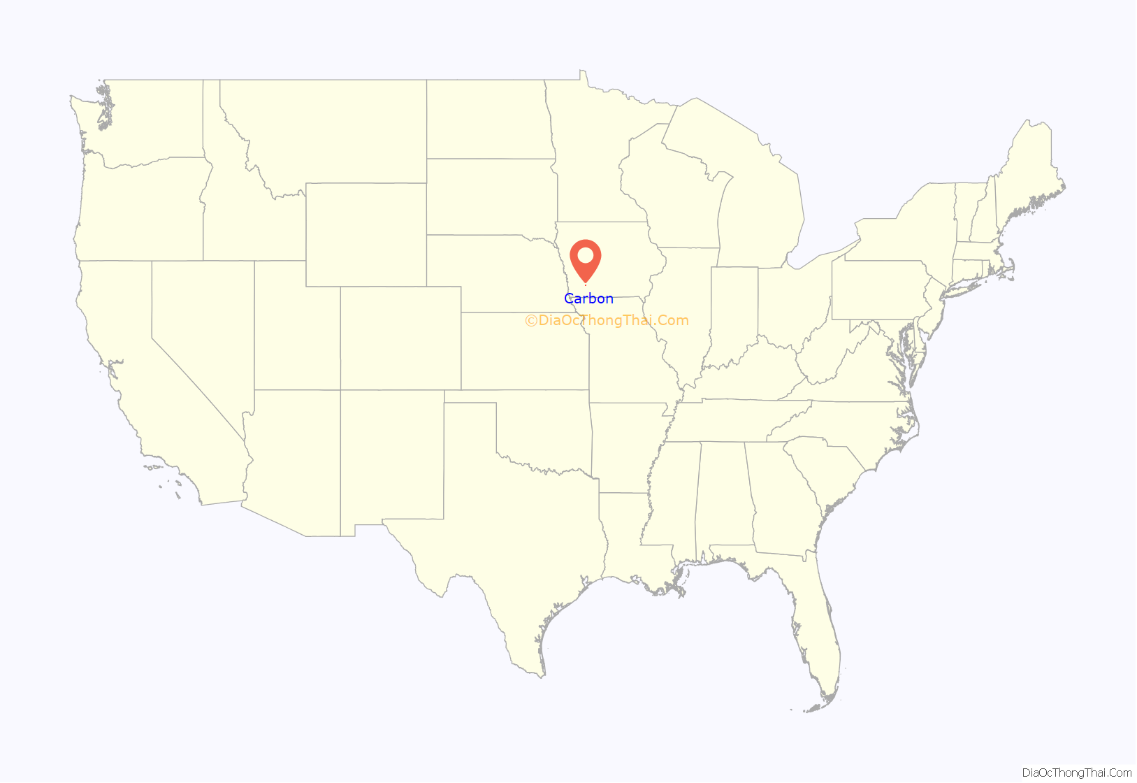
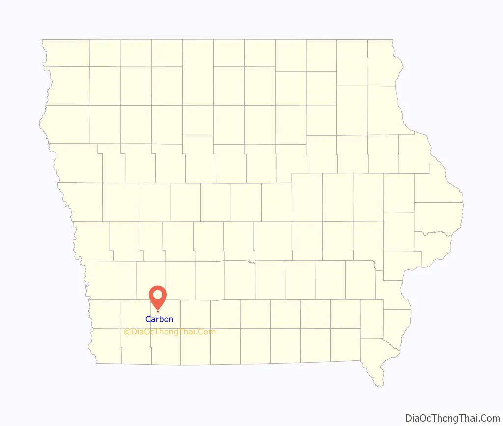
Carbon is a city in Douglas Township, Adams County, Iowa, United States. The population was 36 at the 2020 census.
Note that other places in Iowa have been named Carbon: there was a Carbon Post Office in Davis County, six miles south of Ottumwa, that operated for less than a year in 1881. There was also a Carbon Post Office in Webster County, three miles south-east of Fort Dodge, that operated from 1870 to 1872. A post office on the latter location was known as Gypsum from 1902 to 1905.
| Name: | Carbon city |
|---|---|
| LSAD Code: | 25 |
| LSAD Description: | city (suffix) |
| State: | Iowa |
| County: | Adams County |
| Elevation: | 1,135 ft (346 m) |
| Total Area: | 0.75 sq mi (1.94 km²) |
| Land Area: | 0.75 sq mi (1.94 km²) |
| Water Area: | 0.00 sq mi (0.00 km²) |
| Total Population: | 36 |
| Population Density: | 48.00/sq mi (18.53/km²) |
| ZIP code: | 50839 |
| Area code: | 641 |
| FIPS code: | 1910585 |
| GNISfeature ID: | 0455158 |
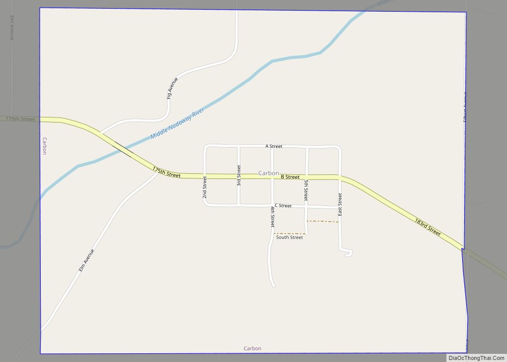
Online Interactive Map
Click on ![]() to view map in "full screen" mode.
to view map in "full screen" mode.
Carbon location map. Where is Carbon city?
History
Carbon is located on the Middle Nodaway River. This was home to the Pottawatomie, Oto and Iowa Indian tribes, until the treaty of 1851 forced their removal to Kansas or Indian Territory, now known as Oklahoma. The first settler to Carbon was Elijah Walters, who established a sawmill there in 1849. He reported seeing huts and old camp fires but stated that the tribes had moved on, only to see an occasional “red man” appear and look over old camp sites and burial sites, then move on. Elijah built a mill on the Middle Nodaway river that became a great social center of its time.
The village was originally named Walters, after its first settler, but was renamed Carbon after the discovery of coal. The town was established in 1873, but was not incorporated until 1903. A post office was established in Carbon in 1874, but from 1877 to 1880, the name was changed to Shinn.
By the time of the Civil War, there were small coal mines along the riverbanks near Carbon. In 1894, there were nine coal mines in Carbon, of which five were then in use. Typical mine shafts were 80 feet deep, working a coal seam 12 to 20 inches (30 to 50 cm) thick. The town at that time was described as a mining camp. Unlike the vast majority of Iowa’s coal camps, the UMWA had no union local in Carbon between 1900 and 1912; during that period, most of Iowa’s coal camps were organized, and the largest UMWA locals in the country were based in Buxton and Centerville, Iowa.
By 1908, it was estimated that the total coal production of the county had exceeded 350,000 tons, despite the lack of any rail connections. Most of this was from the Carbon area. Coal from the Carbon mines was sold locally, with some sold as far away as Corning and other towns within a 25-mile radius. The two most notable mines in the area in 1908 were the Jones, Smith and Tindall mine, a new mine employing 25 miners, 1/4 mile south of Carbon and the J.F. Ruth mine, a year-old mine employing 30 miners, 1/2 mile northeast of town. Both used horse whims to power their hoists, and had minimal safety features. At the time, one other mine had recently been closed by a cave-in, and another was just being opened.
The heyday of the Carbon coal mines lasted approximately 75 years, beginning in the late 19th century and ending in the early 20th century. Carbon has always been known as a lawless town for those that like to fight. Many a gun fight did take place in the streets when the coal mines were booming. Until 1998, the only water supply was on what is now called the “pump road”. On the edge of this road, sits an old hand pump. The pump has stood for over 100 years. Horse-drawn wagons would carry ice from the river and water from the pump back to town. Only one home within the Carbon city limits had a well. It was only in the late 1990s that rural water was finally piped in.
Carbon Road Map
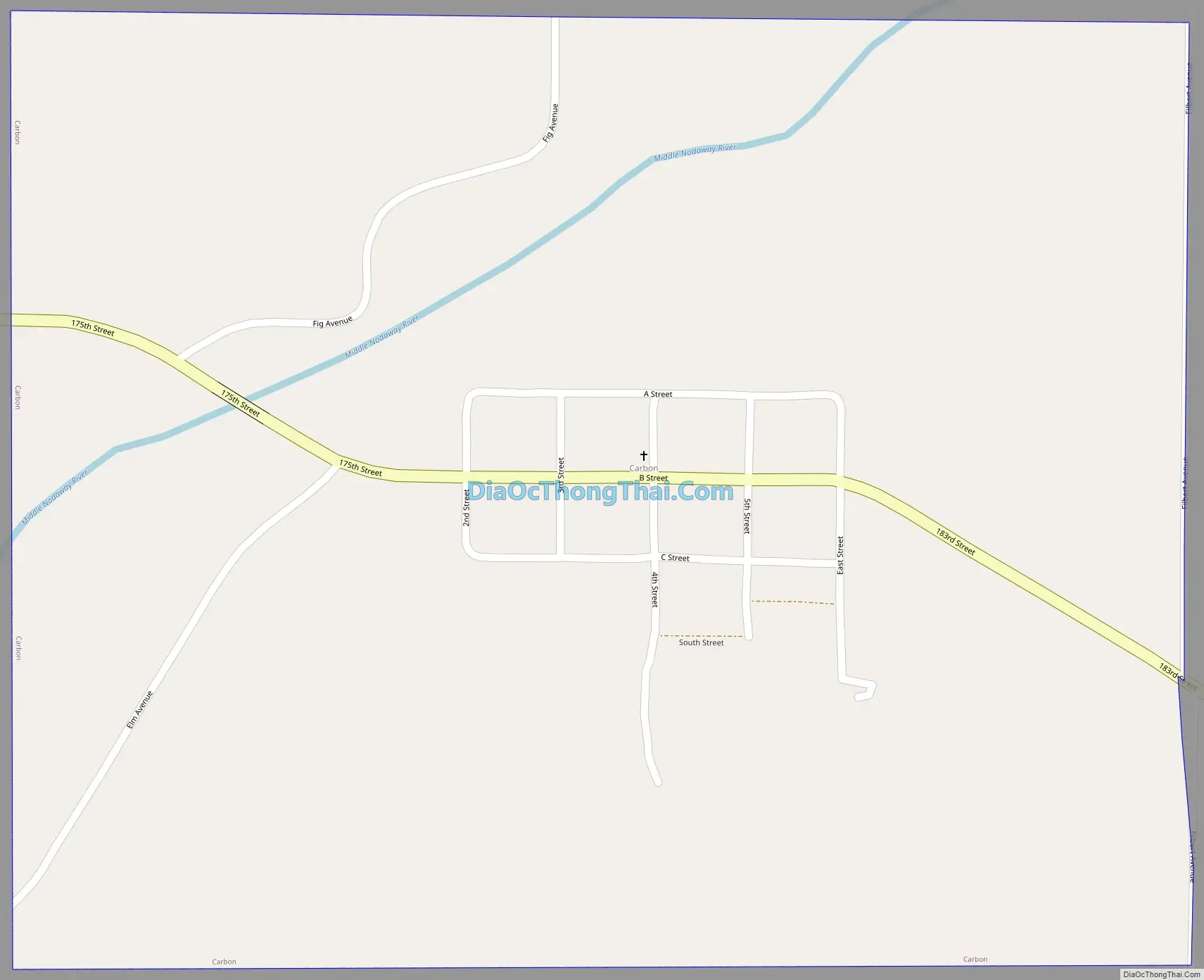
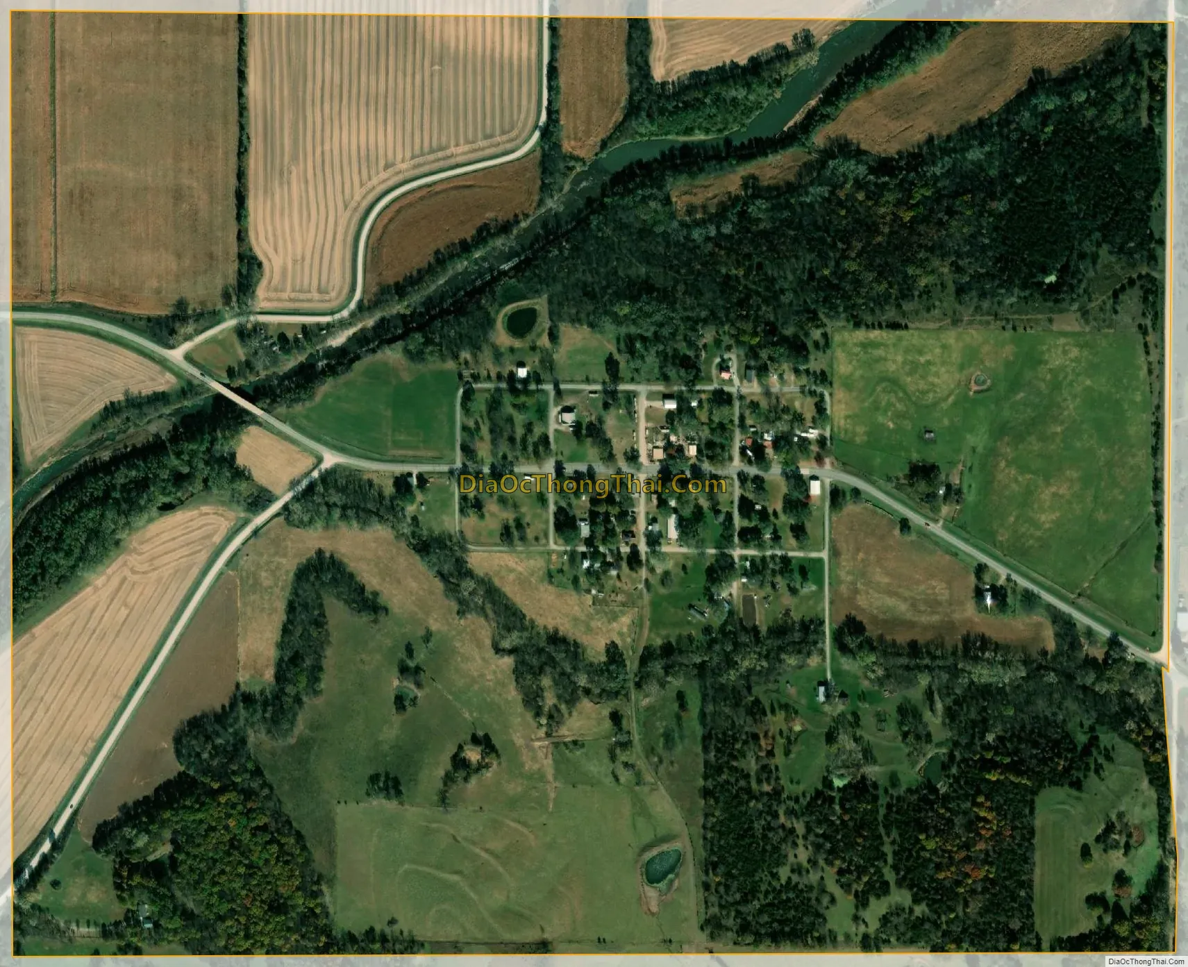
Carbon city Satellite Map
Geography
Carbon is located at 41°3′1″N 94°49′31″W / 41.05028°N 94.82528°W / 41.05028; -94.82528 (41.050208, -94.825171). The town is located on the south bank of the Middle Nodaway River, just east of its confluence with Bull Creek.
According to the United States Census Bureau, the city has a total area of 0.71 square miles (1.84 km), all land.
See also
Map of Iowa State and its subdivision:- Adair
- Adams
- Allamakee
- Appanoose
- Audubon
- Benton
- Black Hawk
- Boone
- Bremer
- Buchanan
- Buena Vista
- Butler
- Calhoun
- Carroll
- Cass
- Cedar
- Cerro Gordo
- Cherokee
- Chickasaw
- Clarke
- Clay
- Clayton
- Clinton
- Crawford
- Dallas
- Davis
- Decatur
- Delaware
- Des Moines
- Dickinson
- Dubuque
- Emmet
- Fayette
- Floyd
- Franklin
- Fremont
- Greene
- Grundy
- Guthrie
- Hamilton
- Hancock
- Hardin
- Harrison
- Henry
- Howard
- Humboldt
- Ida
- Iowa
- Jackson
- Jasper
- Jefferson
- Johnson
- Jones
- Keokuk
- Kossuth
- Lee
- Linn
- Louisa
- Lucas
- Lyon
- Madison
- Mahaska
- Marion
- Marshall
- Mills
- Mitchell
- Monona
- Monroe
- Montgomery
- Muscatine
- O'Brien
- Osceola
- Page
- Palo Alto
- Plymouth
- Pocahontas
- Polk
- Pottawattamie
- Poweshiek
- Ringgold
- Sac
- Scott
- Shelby
- Sioux
- Story
- Tama
- Taylor
- Union
- Van Buren
- Wapello
- Warren
- Washington
- Wayne
- Webster
- Winnebago
- Winneshiek
- Woodbury
- Worth
- Wright
- Alabama
- Alaska
- Arizona
- Arkansas
- California
- Colorado
- Connecticut
- Delaware
- District of Columbia
- Florida
- Georgia
- Hawaii
- Idaho
- Illinois
- Indiana
- Iowa
- Kansas
- Kentucky
- Louisiana
- Maine
- Maryland
- Massachusetts
- Michigan
- Minnesota
- Mississippi
- Missouri
- Montana
- Nebraska
- Nevada
- New Hampshire
- New Jersey
- New Mexico
- New York
- North Carolina
- North Dakota
- Ohio
- Oklahoma
- Oregon
- Pennsylvania
- Rhode Island
- South Carolina
- South Dakota
- Tennessee
- Texas
- Utah
- Vermont
- Virginia
- Washington
- West Virginia
- Wisconsin
- Wyoming