Greencastle is a borough in Franklin County in south-central Pennsylvania, United States. The population was 4,251 at the 2020 census. Greencastle lies within the Cumberland Valley of Pennsylvania.
| Name: | Greencastle borough |
|---|---|
| LSAD Code: | 21 |
| LSAD Description: | borough (suffix) |
| State: | Pennsylvania |
| County: | Franklin County |
| Elevation: | 587 ft (179 m) |
| Total Area: | 1.59 sq mi (4.11 km²) |
| Land Area: | 1.59 sq mi (4.11 km²) |
| Water Area: | 0.00 sq mi (0.00 km²) |
| Total Population: | 4,251 |
| Population Density: | 2,676.95/sq mi (1,033.89/km²) |
| ZIP code: | 17225 |
| Area code: | 717 and 223 |
| FIPS code: | 4230896 |
| Website: | greencastlepa.gov |
Online Interactive Map
Click on ![]() to view map in "full screen" mode.
to view map in "full screen" mode.
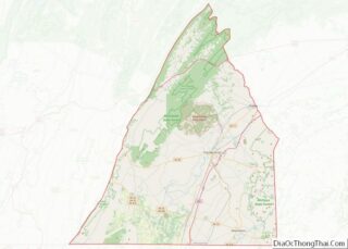
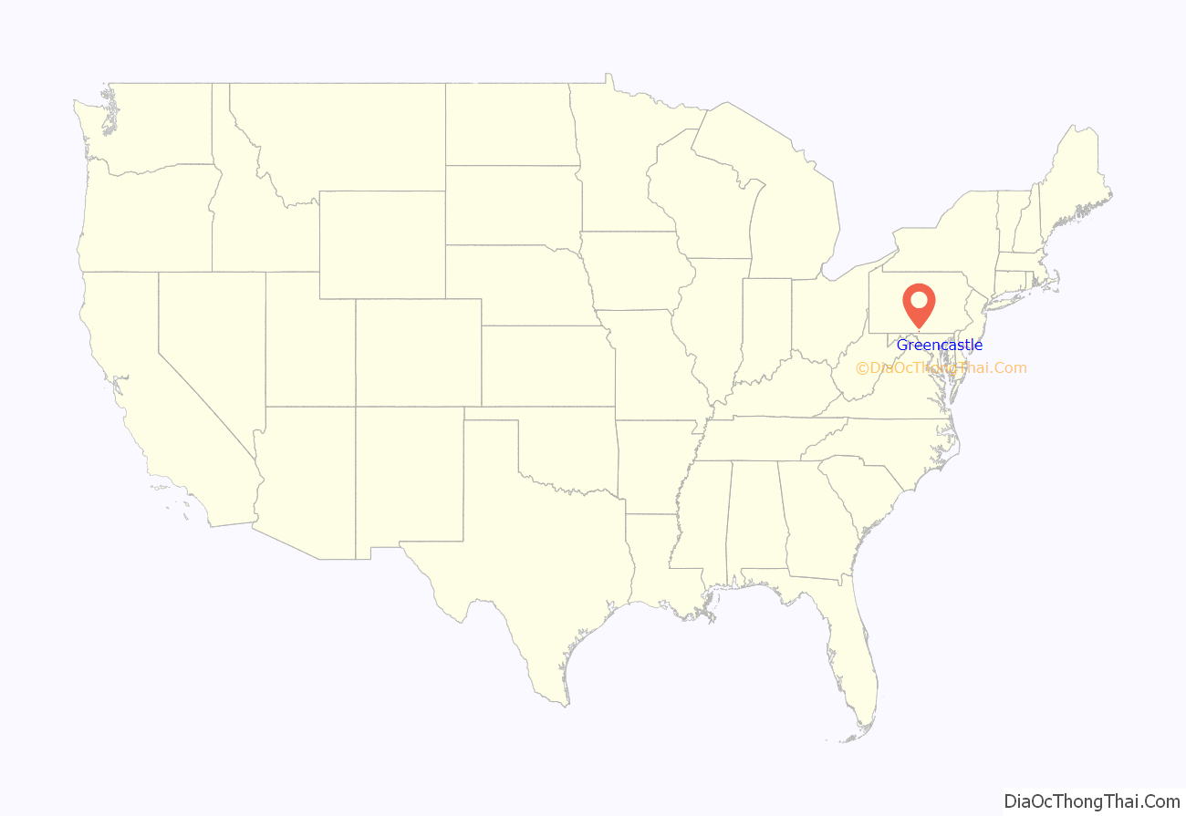
Greencastle location map. Where is Greencastle borough?

History
James Patton, who came to America at age 17 and moved to North Carolina in 1793, started the settlement of Canogege (spelled “Conegoge” by George P. Donahoo). Patton said in an 1839 letter to his descendants that the place was “settled by a moral and orderly people.”
Greencastle was founded in 1783 by John Allison from the Barkdoll House. The town was named after Greencastle, County Donegal, Ireland. It was originally composed of 246 lots. By 1790 there were about 60 houses in Greencastle, homes to approximately 400 people. The town of Greencastle had grown by the mid-nineteenth century to 1,125 residents.
Latter Day Saint settlement
In 1845, following the succession crisis in the Latter Day Saint movement, Sidney Rigdon (one of the three main contenders along with James Strang and Brigham Young for leadership of the Latter Day Saints following the death of Joseph Smith) took his followers to Pennsylvania and formed a Rigdonite Mormon settlement at Greencastle. This settlement had approximately 200 followers. They founded the New Jerusalem settlement between Greencastle and Mercersburg, published the Conochoheague Herald newspaper in Greencastle, and made plans for the construction of a temple. The Rigdonite Mormon settlement at Greencastle only lasted a few years; some former Rigdon followers went to Utah to join Brigham Young, while William Bickerton, who had opposed Rigdon’s move to Greencastle, would eventually reorganize the remaining Pennsylvania branch of the Latter Day Saint movement in Pittsburgh as the Church of Jesus Christ (Bickertonite).
Civil War
Early in the Civil War, Greencastle and neighboring Franklin County communities raised the 126th Pennsylvania Infantry. In the summer of 1863, the war touched close to home when Confederate General Robert E. Lee and his Army of Northern Virginia invaded southern Pennsylvania during the Gettysburg Campaign. From mid-June to early July, those residents of Greencastle who had not fled to safety lived under Confederate rule. On July 2, concurrent with the Battle of Gettysburg in neighboring Adams County, Captain Ulric Dahlgren’s Federal cavalry patrol galloped into Greencastle’s town square, where they surprised and captured several Confederate cavalrymen carrying vital correspondence from Richmond. After the Battle of Gettysburg, Lee’s army began its retreat to Virginia on July 4 and 5. He sent John D. Imboden’s cavalry to escort a large wagon train carrying Confederate wounded. The train, nearly 18 miles (29 km) in length, wound its way through the streets of Greencastle, where a few men of the town attacked the wagon train with axes and hatchets. They succeeded in disabling several wagons before Confederate cavalry chased them away.
Modern era
Following the war, Greencastle grew considerably in the late 19th century during the Industrial Revolution, having several industrial factories built inside the town limits, including the Crowell Manufacturing Company, which constructed farming equipment.
In 1902, Greencastle businessman Philip Baer began a tradition where the town holds a triennial social event known as “Old Home Week”. Every three years, Greencastle townspeople and former residents come together for one week in August in a town-wide reunion to reminisce and fellowship. The most recent Old Home Week Celebration occurred in 2022; the next one will be in 2025.
The Greencastle Historic District, Mitchell-Shook House, and Martin’s Mill Bridge are listed on the National Register of Historic Places.
Greencastle contains many Christian church congregations with longstanding heritage and rich history. The present-day Methodist church has origins dating back to 1805 when Christian Newcomer conducted services in the area.
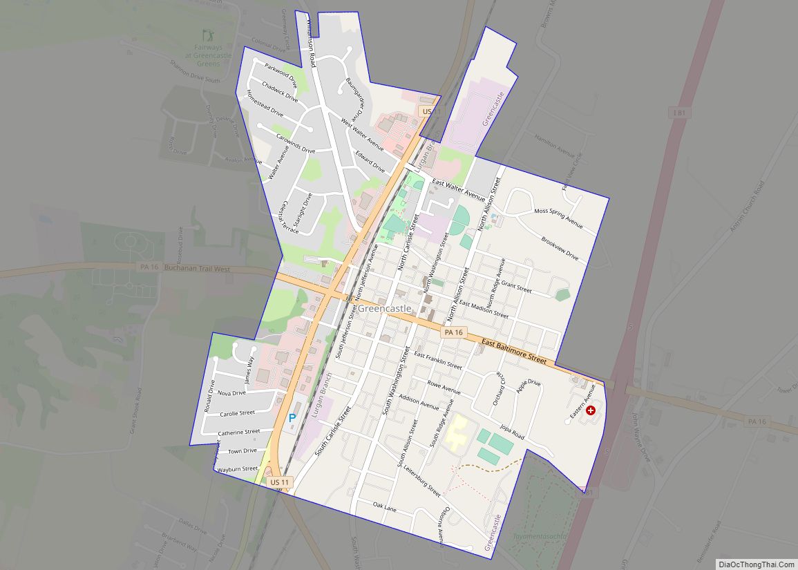
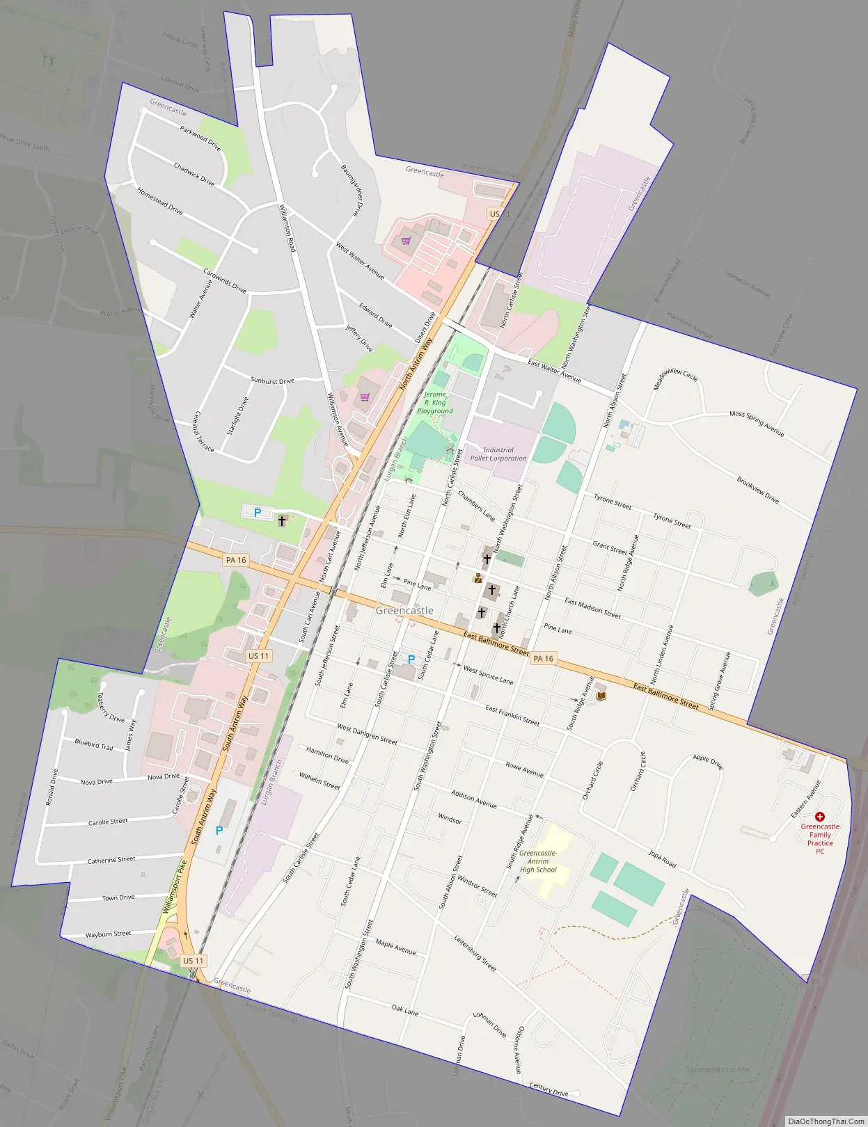
Greencastle Road Map
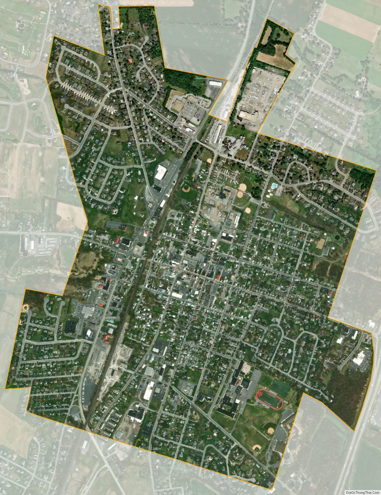
Greencastle city Satellite Map
Geography
Greencastle is located in southern Franklin County at 39°47′22″N 77°43′36″W / 39.78944°N 77.72667°W / 39.78944; -77.72667 (39.789466, -77.726604). It is surrounded by Antrim Township. U.S. Route 11 passes through the western side of the borough as Antrim Way, leading north 11 miles (18 km) to Chambersburg, the county seat, and south 11 miles to Hagerstown, Maryland. Pennsylvania Route 16 passes through the center of the borough as Buchanan Trail, leading east 8 miles (13 km) to Waynesboro and west 10 miles (16 km) to Mercersburg. Interstate 81 passes just east of the borough limits, with access from Exit 3 (US-11) to the south and Exit 5 (PA 16) to the east. I-81 leads northeast 64 miles (103 km) to Harrisburg and south past Hagerstown 53 miles (85 km) to Winchester, Virginia.
According to the United States Census Bureau, the borough has a total area of 1.6 square miles (4.1 km), all land.
See also
Map of Pennsylvania State and its subdivision:- Adams
- Allegheny
- Armstrong
- Beaver
- Bedford
- Berks
- Blair
- Bradford
- Bucks
- Butler
- Cambria
- Cameron
- Carbon
- Centre
- Chester
- Clarion
- Clearfield
- Clinton
- Columbia
- Crawford
- Cumberland
- Dauphin
- Delaware
- Elk
- Erie
- Fayette
- Forest
- Franklin
- Fulton
- Greene
- Huntingdon
- Indiana
- Jefferson
- Juniata
- Lackawanna
- Lancaster
- Lawrence
- Lebanon
- Lehigh
- Luzerne
- Lycoming
- Mc Kean
- Mercer
- Mifflin
- Monroe
- Montgomery
- Montour
- Northampton
- Northumberland
- Perry
- Philadelphia
- Pike
- Potter
- Schuylkill
- Snyder
- Somerset
- Sullivan
- Susquehanna
- Tioga
- Union
- Venango
- Warren
- Washington
- Wayne
- Westmoreland
- Wyoming
- York
- Alabama
- Alaska
- Arizona
- Arkansas
- California
- Colorado
- Connecticut
- Delaware
- District of Columbia
- Florida
- Georgia
- Hawaii
- Idaho
- Illinois
- Indiana
- Iowa
- Kansas
- Kentucky
- Louisiana
- Maine
- Maryland
- Massachusetts
- Michigan
- Minnesota
- Mississippi
- Missouri
- Montana
- Nebraska
- Nevada
- New Hampshire
- New Jersey
- New Mexico
- New York
- North Carolina
- North Dakota
- Ohio
- Oklahoma
- Oregon
- Pennsylvania
- Rhode Island
- South Carolina
- South Dakota
- Tennessee
- Texas
- Utah
- Vermont
- Virginia
- Washington
- West Virginia
- Wisconsin
- Wyoming