Dubuque (/dəˈbjuːk/ (listen), dəb-YOOK) is the county seat of Dubuque County, Iowa, United States, located along the Mississippi River. At the time of the 2020 census, the population of Dubuque was 59,667. The city lies at the junction of Iowa, Illinois, and Wisconsin, a region locally known as the Tri-State Area. It serves as the main commercial, industrial, educational, and cultural center for the area. Geographically, it is part of the Driftless Area, a portion of North America that escaped all three phases of the Wisconsin Glaciation.
Dubuque is a regional tourist destination featuring the city’s unique architecture, casinos and river location. It is home to five institutions of higher education. Dubuque has historically been a center of manufacturing, the local economy also includes health care, publishing, and financial service sectors.
| Name: | Dubuque city |
|---|---|
| LSAD Code: | 25 |
| LSAD Description: | city (suffix) |
| State: | Iowa |
| County: | Dubuque County |
| Founded: | 1833 |
| Incorporated: | January 28, 1857 |
| Elevation: | 617 ft (188 m) |
| Land Area: | 30.92 sq mi (80.09 km²) |
| Water Area: | 1.08 sq mi (2.81 km²) |
| Population Density: | 1,929.60/sq mi (745.03/km²) |
| ZIP code: | 52001–52004, 52099 |
| Area code: | 563 |
| FIPS code: | 1922395 |
| GNISfeature ID: | 0456040 |
| Website: | www.cityofdubuque.org |
Online Interactive Map
Click on ![]() to view map in "full screen" mode.
to view map in "full screen" mode.
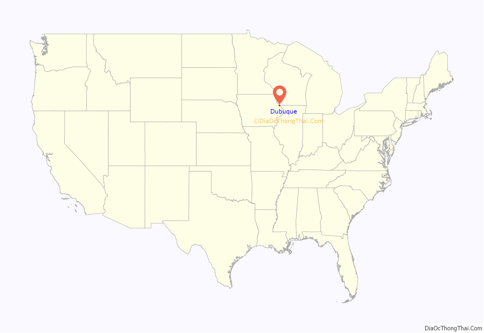
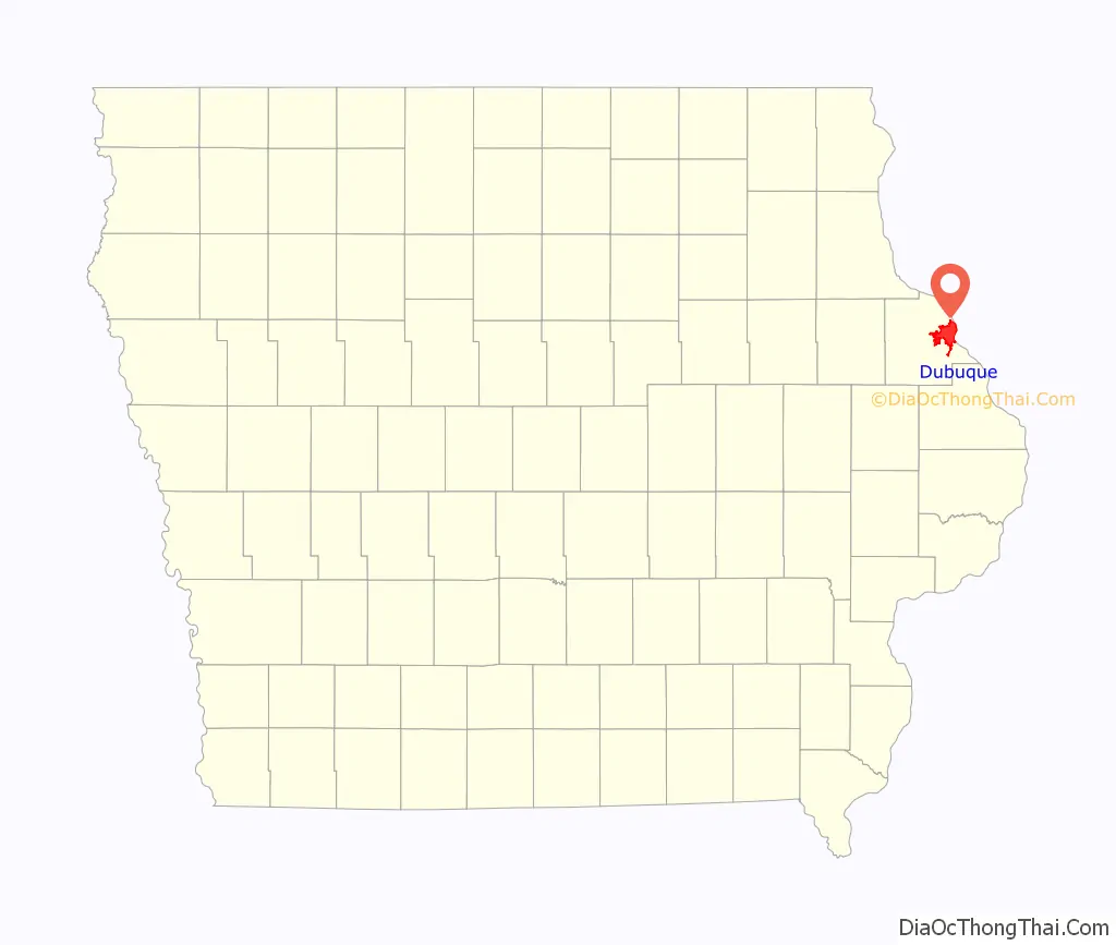
Dubuque location map. Where is Dubuque city?
History
Spain gained control of the Louisiana Territory west of the Mississippi River following the 1763 defeat of the French; the British took over all territory to the east. The first permanent European settler in what is now Dubuque was Quebecois pioneer Julien Dubuque, who arrived in 1785. In 1788, he received permission from the Spanish government and the local Meskwaki American Indians to mine the area’s rich lead deposits. Control of Louisiana and Dubuque’s mines shifted briefly back to France in 1800, then to the United States in 1803, following the Louisiana Purchase. The Meskwaki continued to mine with the full support of the U.S. government until 1830 when the Meskwaki were illegally pushed out of the mine region by American prospectors.
The current City of Dubuque was named after Julien Dubuque, settled at the southern end of a large flat plain adjacent to the Mississippi River. The city was officially chartered in 1833, located in unorganized territory of the United States. The region was designated as the Iowa Territory in 1838 and was included in the newly created State of Iowa in 1846. After the lead resources were exhausted, the city became home to numerous industries. Dubuque became a center for the timber industry because of its proximity to forests in Minnesota and Wisconsin, and was later dominated by various millworking businesses. Also important were boat building, brewing, and later, the railroad industry. In 1874, the Diamond Jo Line moved its company headquarters to Dubuque. Diamond Jo Line established a shipyard at Eagle Point in 1878. Just two years later, the company was the largest employer in Dubuque, putting 78 people to work, 75 of whom worked at the shipyard earning their collective $800–$1,000 per week in wages.
Between 1860 and 1880, Dubuque was one of the 100 largest urban areas in the United States. Iowa’s first church was built by Methodists in 1833. Since then, Iowans have followed a variety of religious traditions.
Beginning in the mid-19th century and into the early 20th century, thousands of poor German and Irish Catholic immigrants came to the city to work in the manufacturing centers. The city’s large Roman Catholic congregations led to its designation as the seat of the newly established Archdiocese of Dubuque. Numerous convents, abbeys, and other religious institutions were built. The ethnic German and Irish descendants maintain a strong Catholic presence in the city. Nicholas E. Gonner (1835-1892), a Catholic immigrant from Pfaffenthal in Luxembourg, founded the Catholic Publishing Company of Dubuque, Iowa. His son Nicholas E. Gonner Jr. (1870-1922) took over in 1892, editing two German-language weeklies, an English-language weekly, and the Daily Tribune, the only Catholic daily newspaper ever published in the United States.
Early in the 20th century, Dubuque was one of several sites of a brass era automobile company, Adams-Farwell; like most others, it folded. Subsequently, Dubuque grew significantly, and industrial activity remained its economic mainstay until the 1980s. Tommy John, who pitched for the Dubuque Packers in 1961, recalled that the town was “about 98 percent Catholic” back then. “Dubuque was the epitome of small-town life,” John wrote. “The people were friendly, everyone knew everybody else, and there wasn’t a thing to do: no excitement, few restaurants or recreation choices, a decaying slum section. So we spent as much time as we could at the ball park. At certain times of the year, the fish flies fester in hordes like a biblical plague.” A series of changes in manufacturing and the onset of the Farm Crisis in the 1980s led to a large decline in the sector and the city’s economy as a whole. In the 1990s, the economy diversified rapidly, shifting away from heavy industry. Tourism, technology, and publishing are now among the largest and fastest-growing businesses. Dubuque attracts well over 1.5 million tourists annually, and the number continues to increase. The city has encouraged the development of the America’s River Project’s tourist attractions in the Port of Dubuque, the expansion of the city’s colleges, and the continued growth of shopping centers, such as Asbury Plaza.
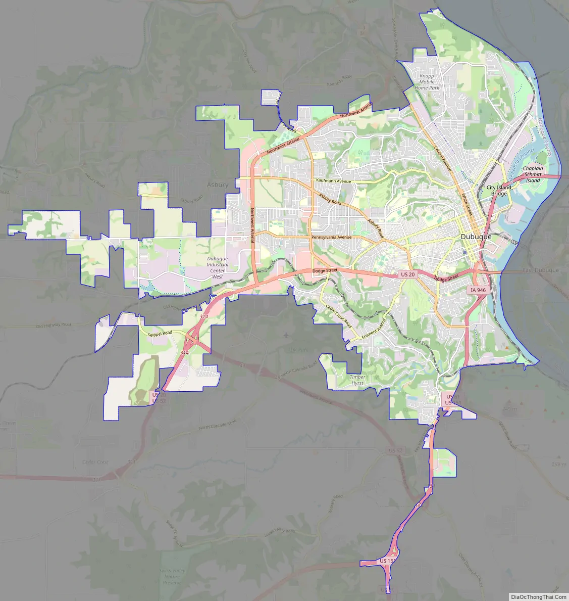
Dubuque Road Map
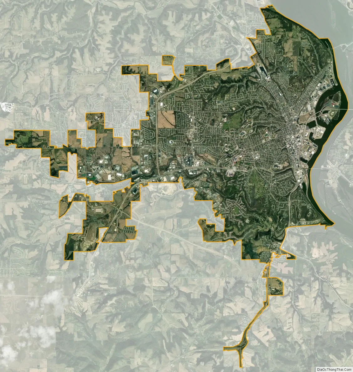
Dubuque city Satellite Map
Geography
Dubuque is located at 42°30′16″N 90°41′13″W / 42.50444°N 90.68694°W / 42.50444; -90.68694 (42.50, -90.69).
According to the United States Census Bureau, the city has a total area of 31.22 square miles (80.86 km), of which 29.97 square miles (77.62 km) are land and 1.25 square miles (3.24 km) are covered by water.
Downtown
Downtown Dubuque contains the city’s central business district and many of its government and cultural institutions. It is the center of Dubuque’s transportation and commercial sectors and the hub of the various outlying districts and neighborhoods. It is in east-central Dubuque, along the Mississippi River, and includes the area north of Maus Park, south of 17th Street, east of the bluff line, and west of the river.
The area is made up of several distinct neighborhoods, each of which has a unique history and character. These include Cable Car Square/Cathedral Square, the Central Business District, Jackson Park/Upper Main, Lower Main, and the Warehouse District. The Warehouse District in particular has experienced massive renovations and an influx in new businesses after a plethora of investments since 2005. Another area of note downtown is the Port of Dubuque, which has had massive new investment and construction since the December 2002 opening of the Grand Harbor Resort and Waterpark. The downtown area includes a number of significant buildings, many of them historic, such as the Shot Tower, St. Raphael’s Cathedral, and the Dubuque County Courthouse, reflecting the city’s early and continuing importance to the region.
North End
Dubuque’s North End area was first settled in the late 19th century by working-class German immigrants. The German-American community sought to establish German Catholic churches separate from the Irish Catholic churches downtown and in the South End. The area retains its working-class roots and is home to some of Dubuque’s largest factories.
The North End is roughly defined, but generally includes the territory north of 17th Street and east of North Grandview Avenue and Kaufmann Avenue. The area is made up of two main hills (west of Central Avenue, and west of Lincoln Avenue), and two main valleys, the Couler Valley (between the two hills), and the “Point” neighborhood, adjacent to the Mississippi River. It is home to Dubuque’s two main cemeteries, Linwood Cemetery (established for Protestants), and Mt. Calvary Cemetery (established for Catholics).
Other important sites in the North End include:
- Bee Branch Creek
- Eagle Point Park
- Holy Ghost Catholic Church
- Linwood Cemetery
- Lock and Dam No. 11
- Mathias Ham House
- Mt. Calvary Cemetery
- Sacred Heart Catholic Church
South End
The South End was traditionally the Irish American neighborhood, and became known as Little Dublin. It centered around southern portions of Downtown Dubuque. Remnants of Irish culture still survive, with Irish pubs such as Murph’s South End Tap and The Lift, and stores such as Shamrock Imports still operating. Irish culture in Dubuque also revolves around the city’s Irish Catholic churches, St. Columbkille’s, St. Patrick’s, and St. Raphael’s Cathedral.
The South End is now much larger, including all the land south of Dodge Street, east of Fremont Avenue, and north of the Key West area. It has many of the city’s “old money” neighborhoods, especially along South Grandview and Fremont Avenues and around the Dubuque Golf & Country Club. Many South End neighborhoods have a more spacious and park-like appearance, contrasting with the more urban North End.
Other important sites in the South End include:
- Archdiocese of Dubuque headquarters
- St. Pius X Seminary
- Louis Murphy Park
- Mines of Spain State Rec. Area
- Mt. Carmel Convent
- St. Raphael’s Cathedral
- Valentine Park
- Wartburg Theological Seminary
West End
Dubuque’s West End is a large, mostly suburban area settled almost entirely after the Second World War. Development was spurred by the onset of the massive baby-boom generation and sharply higher demand for new housing. Expansion began with the construction of the John Deere Homes in the Hillcrest Park neighborhood, which were financed by Deere & Company for its workers. Soon after, many large shopping centers were built, including Plaza 20, and the then-largest enclosed shopping mall in Iowa, Kennedy Mall.
The area continues to expand rapidly, with new subdivisions and shopping centers stretching out for miles from downtown. The West End is not clearly defined, but is generally considered to include all the suburban-style growth west of North Grandview Avenue, the University of Dubuque, and the Valentine Park neighborhood. The area is home to a wide variety of mostly middle-class neighborhoods and city parks, but also includes many of the city’s largest schools, industrial parks, and all its large shopping centers. The area’s expansion has also led to rapid growth in suburban Asbury and exurban Peosta, Iowa, both of which adjoin the West Side. The west side has also been acknowledged by a viral YouTube video named Rappin’ for Jesus, where a church named the “West Dubuque Second Church of Christ” was mentioned. Both the video and church were made up, and the video was labeled as a hoax.
Other important sites in the West End include:
- Asbury Plaza
- Asbury Square Shopping Center
- Bunker Hill Golf Course
- Dubuque Arboretum & Botanical Gardens
- Emmaus Bible College
- Flora Park
- Hempstead High School
- Kennedy Mall
- Medical Associates Clinic – West Campus
- Mt. Loretto Convent
- Plaza 20
- Resurrection Catholic Church
- Townsquare Media Dubuque radio stations
- Tri-State Christian School
- Veterans Memorial Park
- Wacker Plaza
- Wahlert High School
- Warren Plaza
Redstone Bed & Breakfast
Old Cable elevator
Mississippi River
The Washington Park Gazebo
Climate
Dubuque has a humid continental climate (Köppen Dfa), which gives it four distinct seasons. The weather is not as extreme as that in other parts of the Midwest, such as Minnesota or Wisconsin. Spring is usually wet and rainy, summers are sunny and warm, autumn is mild, and winters are typically cloudy and snowy.
- ^ Mean monthly maxima and minima (i.e. the expected highest and lowest temperature readings at any point during the year or given month) calculated based on data at said location from 1991 to 2020.
See also
Map of Iowa State and its subdivision:- Adair
- Adams
- Allamakee
- Appanoose
- Audubon
- Benton
- Black Hawk
- Boone
- Bremer
- Buchanan
- Buena Vista
- Butler
- Calhoun
- Carroll
- Cass
- Cedar
- Cerro Gordo
- Cherokee
- Chickasaw
- Clarke
- Clay
- Clayton
- Clinton
- Crawford
- Dallas
- Davis
- Decatur
- Delaware
- Des Moines
- Dickinson
- Dubuque
- Emmet
- Fayette
- Floyd
- Franklin
- Fremont
- Greene
- Grundy
- Guthrie
- Hamilton
- Hancock
- Hardin
- Harrison
- Henry
- Howard
- Humboldt
- Ida
- Iowa
- Jackson
- Jasper
- Jefferson
- Johnson
- Jones
- Keokuk
- Kossuth
- Lee
- Linn
- Louisa
- Lucas
- Lyon
- Madison
- Mahaska
- Marion
- Marshall
- Mills
- Mitchell
- Monona
- Monroe
- Montgomery
- Muscatine
- O'Brien
- Osceola
- Page
- Palo Alto
- Plymouth
- Pocahontas
- Polk
- Pottawattamie
- Poweshiek
- Ringgold
- Sac
- Scott
- Shelby
- Sioux
- Story
- Tama
- Taylor
- Union
- Van Buren
- Wapello
- Warren
- Washington
- Wayne
- Webster
- Winnebago
- Winneshiek
- Woodbury
- Worth
- Wright
- Alabama
- Alaska
- Arizona
- Arkansas
- California
- Colorado
- Connecticut
- Delaware
- District of Columbia
- Florida
- Georgia
- Hawaii
- Idaho
- Illinois
- Indiana
- Iowa
- Kansas
- Kentucky
- Louisiana
- Maine
- Maryland
- Massachusetts
- Michigan
- Minnesota
- Mississippi
- Missouri
- Montana
- Nebraska
- Nevada
- New Hampshire
- New Jersey
- New Mexico
- New York
- North Carolina
- North Dakota
- Ohio
- Oklahoma
- Oregon
- Pennsylvania
- Rhode Island
- South Carolina
- South Dakota
- Tennessee
- Texas
- Utah
- Vermont
- Virginia
- Washington
- West Virginia
- Wisconsin
- Wyoming