Itasca (/aɪˈtæskə/) is a village in DuPage County, Illinois, United States. Per the 2020 Census, the population was 9,543. Located approximately 25 miles northwest of downtown Chicago, Itasca is close to O’Hare International Airport, major expressways and rail transportation. Itasca is home to a country club, a resort and shares a border with Medinah’s legendary golf course. The population was 9,725 at the 2020 census. BusinessWeek rated Itasca as the Best Affordable Suburb in the state of Illinois.
| Name: | Itasca village |
|---|---|
| LSAD Code: | 47 |
| LSAD Description: | village (suffix) |
| State: | Illinois |
| County: | DuPage County |
| Incorporated: | 1890 |
| Total Area: | 5.14 sq mi (13.32 km²) |
| Land Area: | 5.02 sq mi (13.01 km²) |
| Water Area: | 0.12 sq mi (0.32 km²) |
| Total Population: | 9,543 |
| Population Density: | 1,900.24/sq mi (733.72/km²) |
| Area code: | 630 |
| FIPS code: | 1737907 |
| Website: | www.itasca.com |
Online Interactive Map
Click on ![]() to view map in "full screen" mode.
to view map in "full screen" mode.
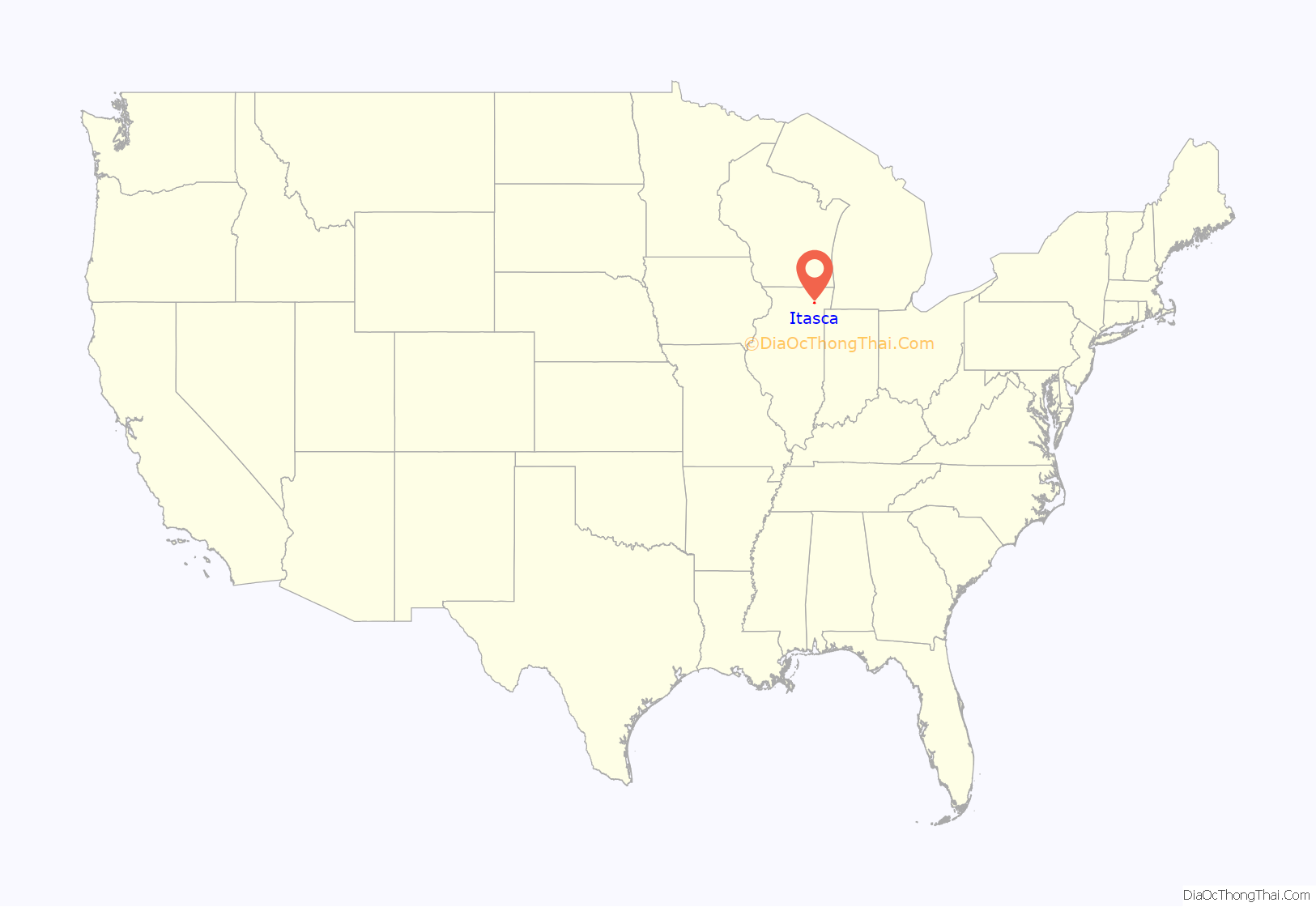
Itasca location map. Where is Itasca village?
History
Itasca was first settled by Elijah Smith in 1841. Smith practiced medicine in Boston. In May 1841, at the advice of his colleagues he set out to find a suitable site for doctoring, farming, and raising a family. He traveled from New York via Detroit and headed toward DuPage County. His parchment government land title dated March 10, 1843, was signed by John Tyler, President of the United States. The document gave Smith title to the land that is now bounded by the railroad tracks on the south, Maple Street on the west, Cherry Street on the east, and Division Street on the north. The post office was established in 1846 and took on various names, such as Bremen, Pierce (after Charles Pierce, who ran a trading post), and Sagon. The name Itasca comes from Lake Itasca. In the 1860s the first school was built. It was a small wooden structure with one room. The building was located on a site near the present First Presbyterian Church.
In 1873 Smith plotted eighty acres of his land into lots. The Chicago and Pacific Railroad was completed from Chicago to Elgin, with stations at Bensenville, Wood Dale (called Lester) and Itasca. Smith gave the right-of-way to encourage location of the tracks through the settlement. He donated $400 to help build a station.
The Chicago and Pacific Railroad became insolvent. In 1880 the road went into the hands of the Chicago, Milwaukee, St. Paul and Pacific Railroad, a newly formed corporation combining several rail networks.
The citizens of Itasca decided in 1890 to incorporate into a village. At a meeting at his mill, A. G. Chessman was elected the first Village President. Irving Park Road was first called the Chicago and Elgin Road. At an 1891 Village Board meeting, the name was changed to Elgin Avenue.
The 1900s
The Village of Itasca created a Historical Commission in 1985 to retain the aesthetic beauty, character, and historical integrity of the Village. The Village of Itasca is committed to the preservation of its pre-1900 and early 1900 homes, buildings, structures, and places.
In 1987, the Village adopted the Historic Preservation Ordinance which provides a mechanism to identify and preserve the special distinctive historic, aesthetic, architectural and/or landscaping characteristics of the Village’s cultural, social, economic, political and architectural history.
The Itasca Historical District includes the following area: Bounded on the north by North Street, on the south by Bloomingdale Road, east to Irving Park, Irving Park east to Rush Street; on the east by Cherry Street extended to Schiller Street then west to Rush Street, then south to Irving Park Road and on the west by Catalpa Avenue extended to Bloomingdale Road.
The Spire, which is Itasca’s most familiar landmark, graces the top of what was formerly the Lutheran Church of St. Luke. This edifice was erected in 1907 by builder Fred Westendorf. Pastor Frederick Zersen served the congregation for thirty-eight years. Church services were in German. It was not until 1926 that English services were held twice a month. German was also taught in the church school. Until 1916, there was no bank in Itasca. Herman H. Franzen took deposits for Village residents to the Roselle Bank each morning, making the trip regularly on the 9:00 AM train. In 1916, two banks opened within weeks of each other. The Itasca State Bank had as its president H. F. Lawrence. The cashier was Elmer H. Franzen. The second bank was called the Dairyman’s Bank of Northern Illinois, and was opened by F. N. Peck. Peck opened a total of four banks, but the Depression forced him to close them all. The Franzen banks in Itasca, Roselle, and Fox Lake were sound throughout the hard times of the 1920s, and emerged successfully from the Depression.
Telephone service had come to Itasca in 1899. Electricity was first installed in some homes in 1923. The bustling community soon gained another facility. The Itasca Country Club was opened in the spring of 1925.
The rural village of the 1800s and early 1900s retained its atmosphere until the 1940s. A new word then began to enter the American vocabulary: suburb. The influence of the city increased as population increased. Commuting daily to the Loop became the routine for many of the Village wage earners. By 1982, the population had grown to 7,192. Annexations had resulted in fifty miles of Village streets, more parks, and two industrial areas to serve. Providing safety and service as population increased required the establishment of departments of public works, of sewer and water, of building and police. A park district, a Village library, and a fire district were formed.
High school students from Itasca attended Bensenville’s Fenton High School and Glenbard High School, a combined Glen Ellyn-Lombard school. A high school district, District 108, was organized in 1953. Lake Park High School, with students from Itasca, Roselle, Medinah, Keeneyville and Bloomingdale, opened in September 1956.
Modern industry was foreign to Itasca until 1961 when Central Manufacturing District (CMD) bought about 400 acres on the western edge of the village. An industrial park was established, and such national companies as Continental Can and FMC soon moved in. In 1970, the Itasca Industrial Park was established to the east of the Village, and attracted many more industries.
Anvan Corporation built a Holiday Inn on Irving Park east of Route 53. The building was of modular construction, the first such hotel in the nation to be built in this manner.
In 1969, Carson Pirie Scott purchased Nordic Hills Country Club. Two 10-story tower hotel buildings were constructed adjacent to the eighteen-hole golf course. In 1973, the Carson Inn/Nordic Hills facility was annexed to the village. Today, it is the Eaglewood Resort.
In October 1979, Trammell Crow Company of Texas broke ground for Hamilton Lakes. A 420-room Stouffer Hotel and a ten-story office building, completed in 1981, constituted the first phase of the project, situated on 278 acres on the northwest edge of Itasca. To date 15 buildings out of an estimated 26 have been completed, amounting to 2,767,589 gross square feet of floor space with an ultimate development of 4,490,700 gross square feet. A 16-story office building was added to the complex in 1984.
In 1966, the Village purchased 60 acres of land south of Irving Park Road. This established a green belt area to ensure both open space and water retention. In 1968 the Spring Brook Nature Center was formed.
A Master Plan for this area was adopted in 1965, and continues to guide the community into its future. Itasca, having celebrated its 100th anniversary in 1990, continues to control its development according to the individuality of its past.
The overall growth and development of the Village has and is being controlled by the Comprehensive Plan that was first adopted in 1942 and has been amended in 1959, 1979, and 1993.
Shirley H. Ketter, the first female Mayor of Itasca monumentally served as Village President of Itasca from 1983 to 1997. Former Mayor Ketter is after whom Itasca’s Ketter Drive was named in 1999 in honor of her role with the Hamilton Lakes Business Park, which according to Mayor Gigi Gruber, Ketter “created and developed the whole Hamilton project.”
Outstanding residential neighborhoods, first-rate schools, and beautiful parks distinguish Itasca as a quality community. Most importantly, we have worked to retain our small town charm with a lovely historic district and churches of all architectural styles.
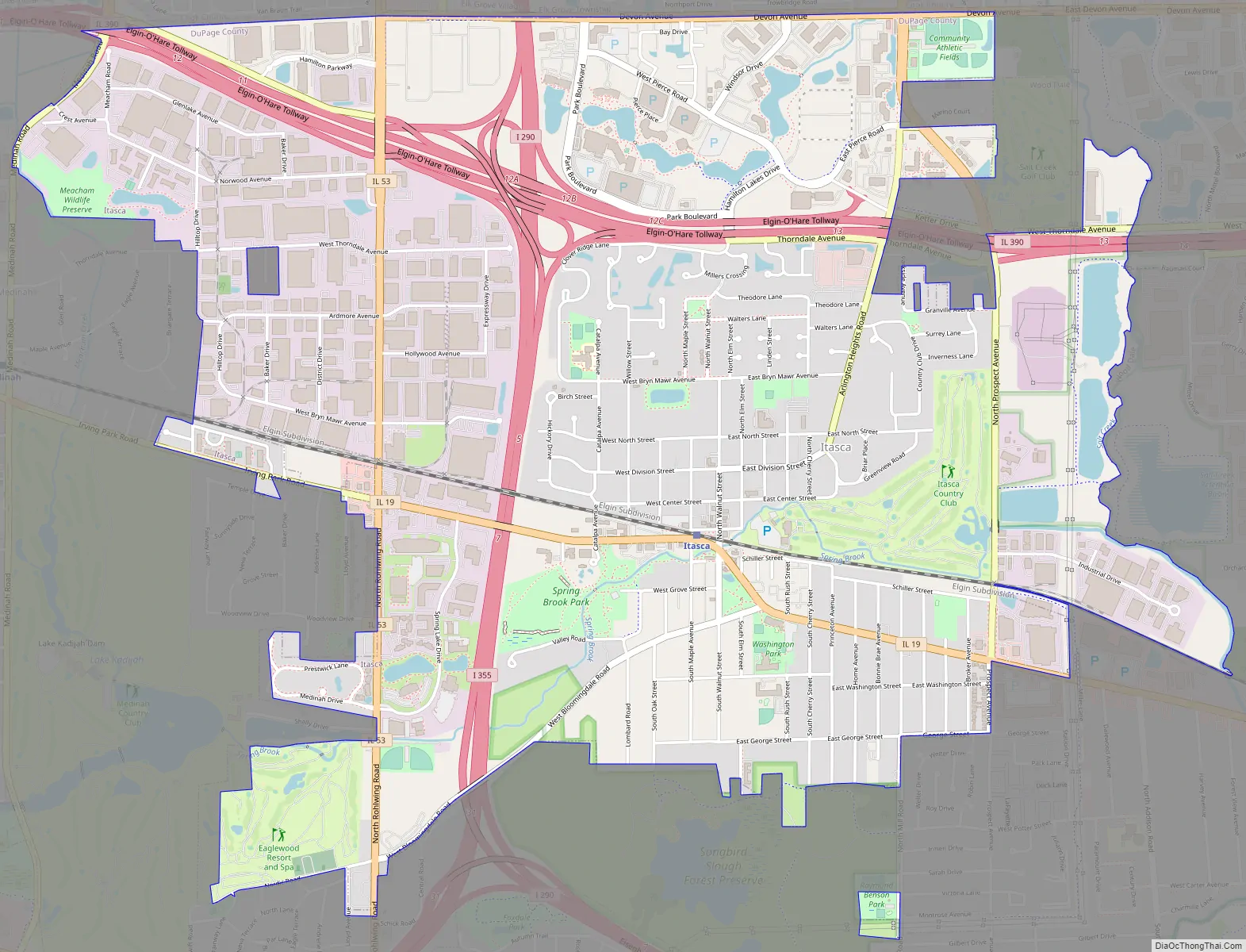
Itasca Road Map
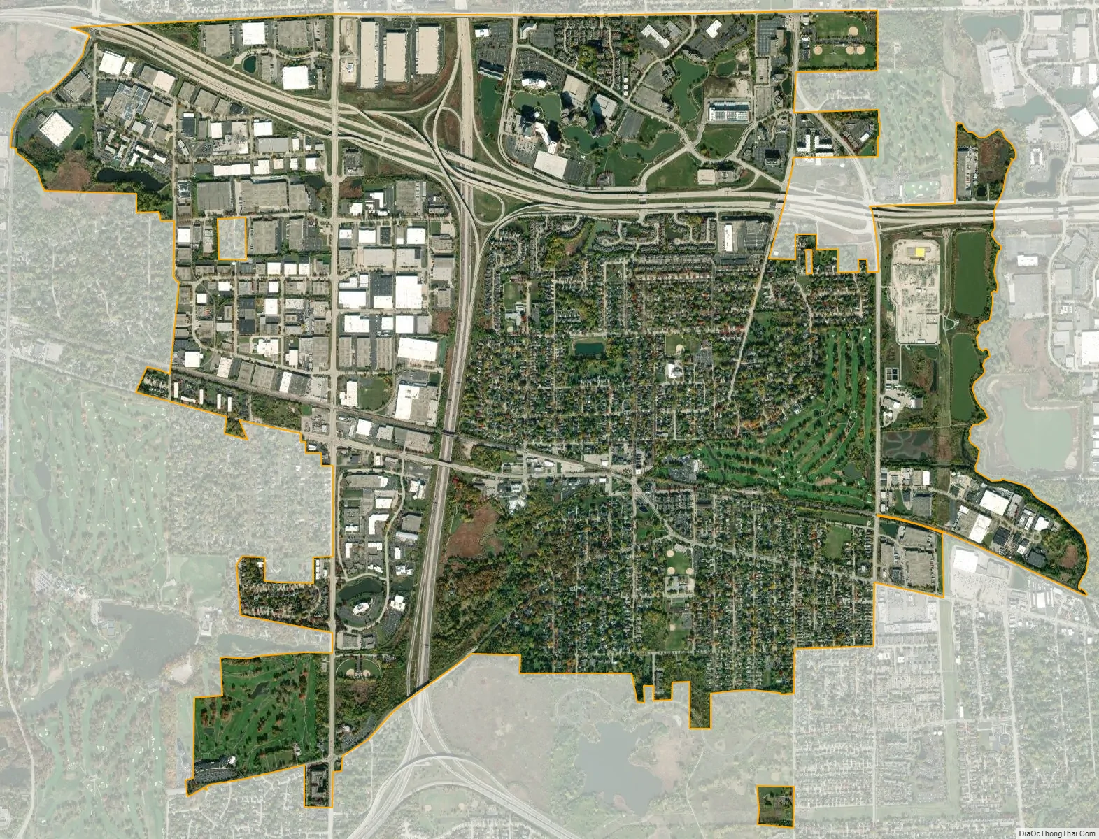
Itasca city Satellite Map
Geography
Itasca is located at 41°58′29″N 88°1′7″W / 41.97472°N 88.01861°W / 41.97472; -88.01861 (41.974678, -88.018513).
According to the 2021 census gazetteer files, Itasca has a total area of 5.14 square miles (13.31 km), of which 5.02 square miles (13.00 km) (or 97.63%) is land and 0.12 square miles (0.31 km) (or 2.37%) is water.
See also
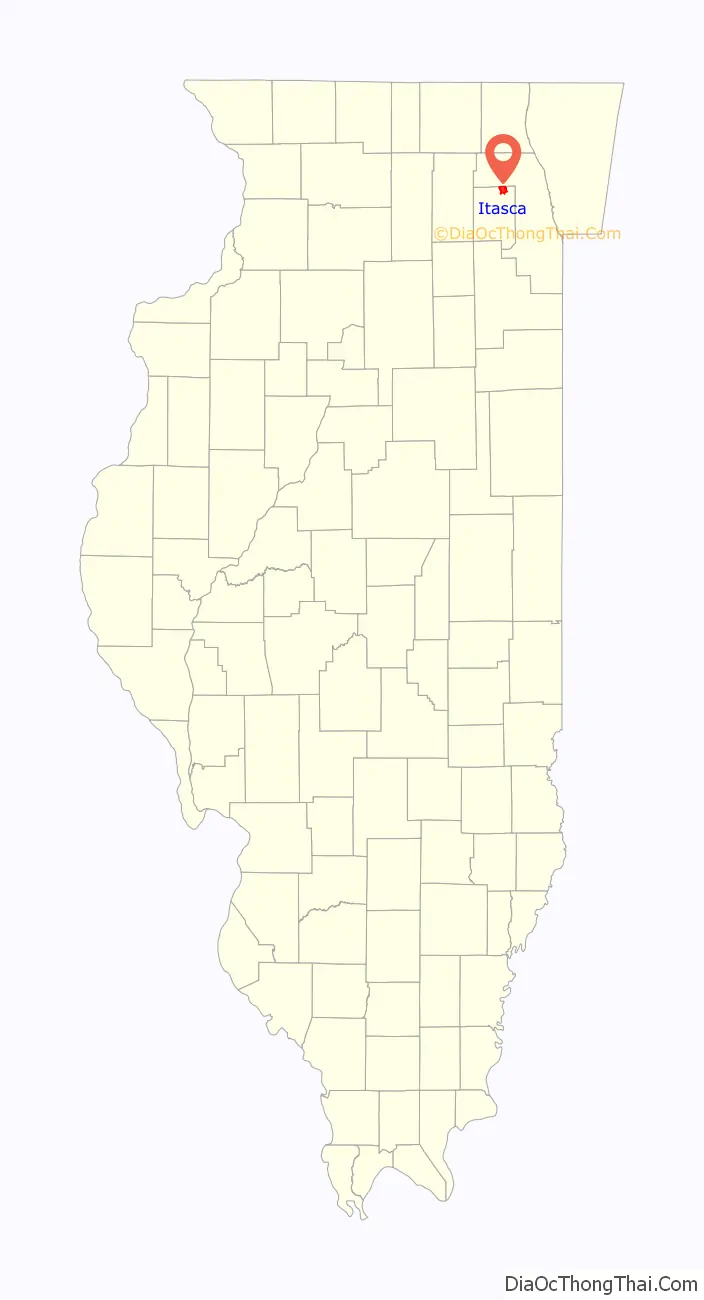
Map of Illinois State and its subdivision:- Adams
- Alexander
- Bond
- Boone
- Brown
- Bureau
- Calhoun
- Carroll
- Cass
- Champaign
- Christian
- Clark
- Clay
- Clinton
- Coles
- Cook
- Crawford
- Cumberland
- De Kalb
- De Witt
- Douglas
- Dupage
- Edgar
- Edwards
- Effingham
- Fayette
- Ford
- Franklin
- Fulton
- Gallatin
- Greene
- Grundy
- Hamilton
- Hancock
- Hardin
- Henderson
- Henry
- Iroquois
- Jackson
- Jasper
- Jefferson
- Jersey
- Jo Daviess
- Johnson
- Kane
- Kankakee
- Kendall
- Knox
- La Salle
- Lake
- Lake Michigan
- Lawrence
- Lee
- Livingston
- Logan
- Macon
- Macoupin
- Madison
- Marion
- Marshall
- Mason
- Massac
- McDonough
- McHenry
- McLean
- Menard
- Mercer
- Monroe
- Montgomery
- Morgan
- Moultrie
- Ogle
- Peoria
- Perry
- Piatt
- Pike
- Pope
- Pulaski
- Putnam
- Randolph
- Richland
- Rock Island
- Saint Clair
- Saline
- Sangamon
- Schuyler
- Scott
- Shelby
- Stark
- Stephenson
- Tazewell
- Union
- Vermilion
- Wabash
- Warren
- Washington
- Wayne
- White
- Whiteside
- Will
- Williamson
- Winnebago
- Woodford
- Alabama
- Alaska
- Arizona
- Arkansas
- California
- Colorado
- Connecticut
- Delaware
- District of Columbia
- Florida
- Georgia
- Hawaii
- Idaho
- Illinois
- Indiana
- Iowa
- Kansas
- Kentucky
- Louisiana
- Maine
- Maryland
- Massachusetts
- Michigan
- Minnesota
- Mississippi
- Missouri
- Montana
- Nebraska
- Nevada
- New Hampshire
- New Jersey
- New Mexico
- New York
- North Carolina
- North Dakota
- Ohio
- Oklahoma
- Oregon
- Pennsylvania
- Rhode Island
- South Carolina
- South Dakota
- Tennessee
- Texas
- Utah
- Vermont
- Virginia
- Washington
- West Virginia
- Wisconsin
- Wyoming