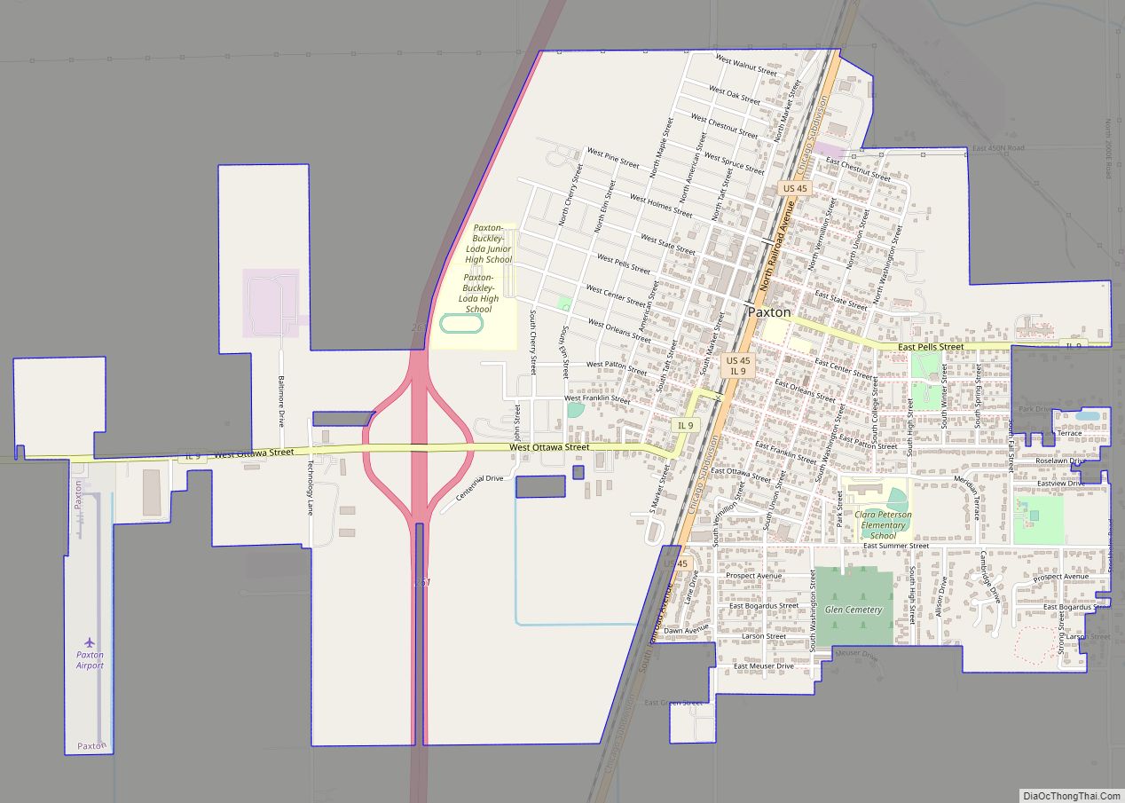
Paxton is a city in Ford County, Illinois, United States. The population was 4,473 at the 2010 census. It is the county seat of Ford County.
| Name: | Paxton city |
|---|---|
| LSAD Code: | 25 |
| LSAD Description: | city (suffix) |
| State: | Illinois |
| County: | Ford County |
| Elevation: | 798 ft (243 m) |
| Total Area: | 3.04 sq mi (7.88 km²) |
| Land Area: | 3.04 sq mi (7.86 km²) |
| Water Area: | 0.01 sq mi (0.02 km²) |
| Total Population: | 4,450 |
| Population Density: | 1,465.74/sq mi (565.98/km²) |
| Area code: | 217 |
| FIPS code: | 1758239 |
| Website: | http://www.cityofpaxton.com/ |
Online Interactive Map
Click on ![]() to view map in "full screen" mode.
to view map in "full screen" mode.
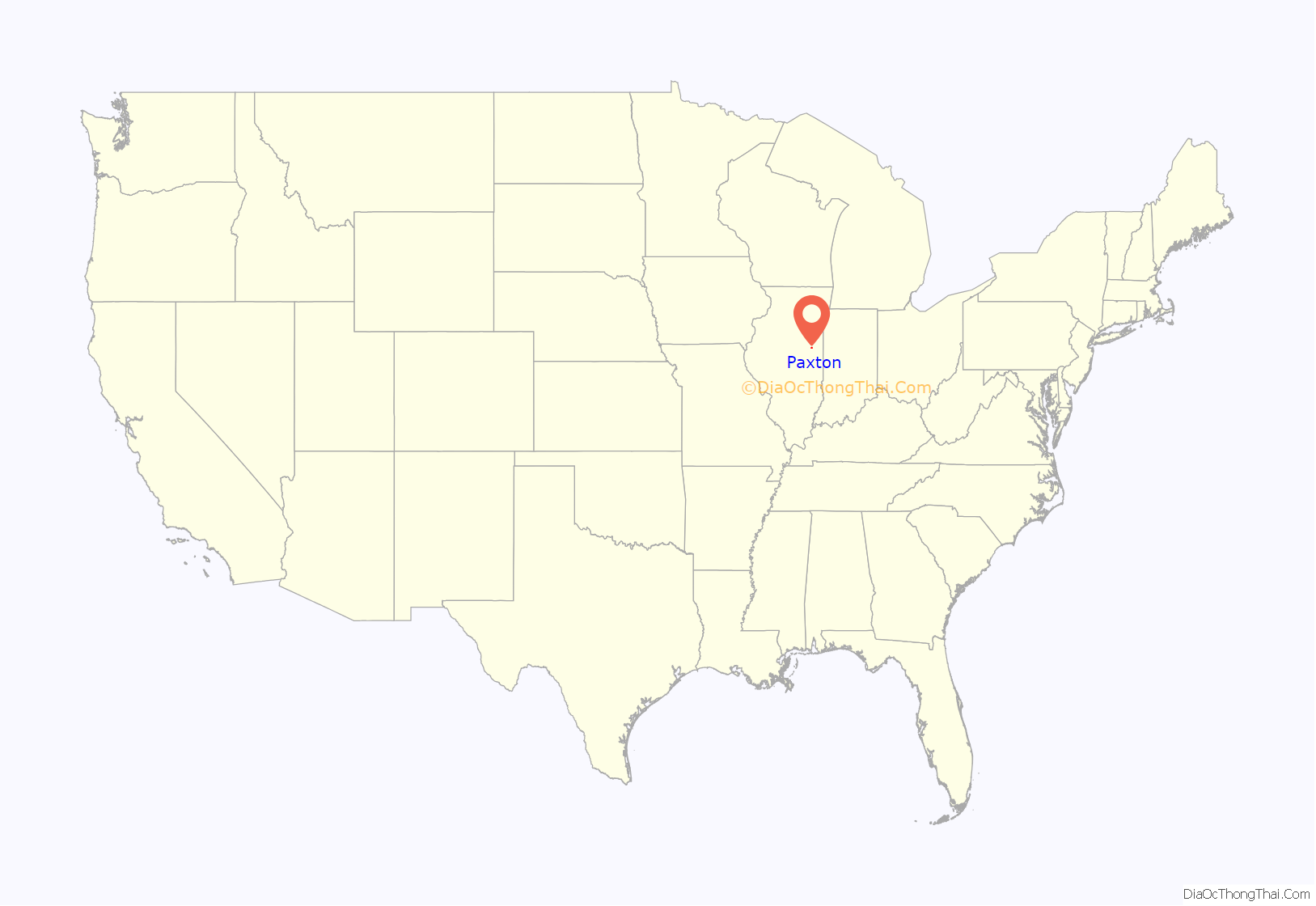
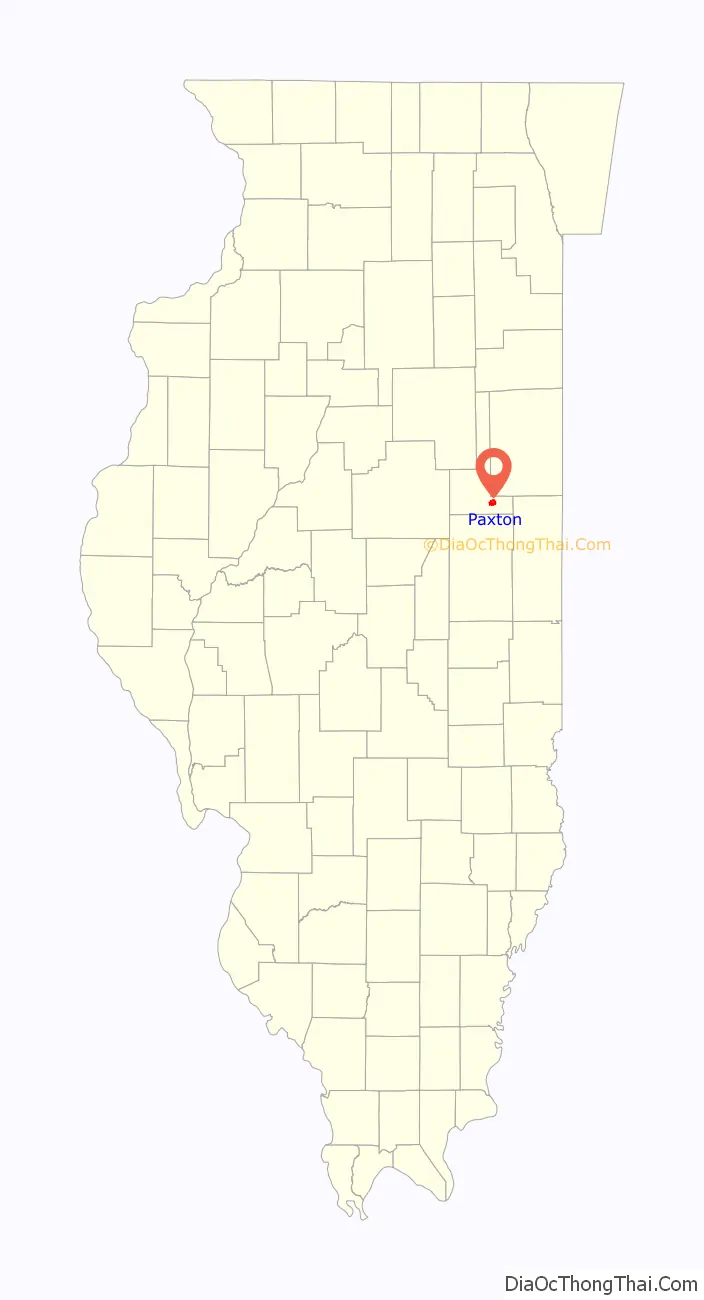
Paxton location map. Where is Paxton city?
History
The town was initially named Prairie City in the late 1840s, then Prospect City by an Illinois Central Railroad official in 1855. However, as Wilbur W. Sauer says that residents noted the town was “all prospect and no city.” In 1859, it was renamed for Sir Joseph Paxton, architect of the Crystal Palace, who was a major shareholder in the Illinois Central Railroad, which in 1856 was the longest span of railroad in the world (Chicago to Cairo). It was rumored that Paxton was interested in organizing an English settlement in Illinois. The colony never materialized, but the town kept the name. Founded in 1859, Paxton celebrated its sesquicentennial in 2009.
Augustana College was located in Paxton from 1863 to 1875, aided by a community effort led by recent Swedish immigrants to fund educational and cultural opportunities for citizens.
An early public high school was established in 1872; it served the surrounding area for the next several decades, culminating in the formation of a community high school district in May 1920. The local school’s mascot was the Paxton Mustangs until consolidation with the Buckley-Loda Rockets district in 1990 formed the current Paxton-Buckley-Loda School District, known as the PBL Panthers. The school is a member of the IESA and IHSA for interscholastic sports and activities.
The Ford County Courthouse in Paxton was built in 1906, and boasts many murals painted by the Works Progress Administration during the 1930s.
On June 22, 1919, former President William Howard Taft visited Paxton while on his way to Champaign. After disembarking from a long train ride, Taft delivered a speech in the Pells Park Pavilion in favor of U.S. entry into the newly formed League of Nations. Taft’s appearance is a testament to the Paxton Chautauqua, which was held in Pells Park from 1905 to 1930, attracting musicians, speakers and entertainment from all over the United States. Taft is one of four U.S. Presidents to visit Ford County, joining William McKinley (Gibson City in 1897), Richard Nixon (Melvin as vice president in 1957), and Gerald Ford (Melvin in 1974).
From 1865 to 2007, the Paxton Daily Record was published in Paxton, making the paper one of the longest-running daily newspapers of its size in the state of Illinois. Today, the Ford County Chronicle, a digital publication managed by the former paper’s staff, continues to publish local news, sports and other event information.
Due to Paxton having the highest elevation points in the area, the Illinois Central Railroad dug out ground so that the railroad could move at the same elevation, but underneath the city of Paxton. When the railroad was cut (around the 1920s), several bridges were built across the railroad to connect the east and west sides of Paxton. Presently, there are three vehicular bridges, which are located at Holmes Street, Pells Street and Patton Street, and a pedestrian bridge at Orleans Street.
The town also hosts the Historic Brick Water Tower & Ford County Historical Society Museum, which opened on July 4, 2007. The 80-foot (24 m) tall brick water tower was built in 1887 and is listed on the National Register of Historic Places. The Paxton Foundation, a local historical preservation group, is currently restoring the Old Ford County Jail and Sheriff’s Residence, built in 1871. Located on West State Street adjacent to the Courthouse, it will be turned into a museum. Another local building on the National Register of Historic Places is the Paxton Carnegie Library, which was built in 1903.
The community has many homes built in the late 19th century, some of which are now part of an historic homes walking tour. Many of the home owners have won awards from various preservation and restoration societies for their efforts in maintaining the architectural heritage of these important landmarks. The Paxton Area Chamber of Commerce and PRIDE in Paxton, a member of the Illinois Main Street Program, currently promote local businesses and events in the historic downtown district.
Paxton Road Map
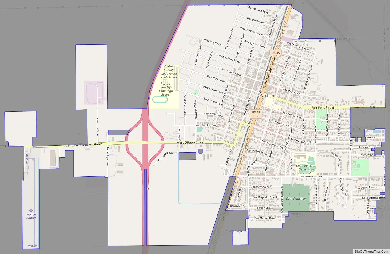
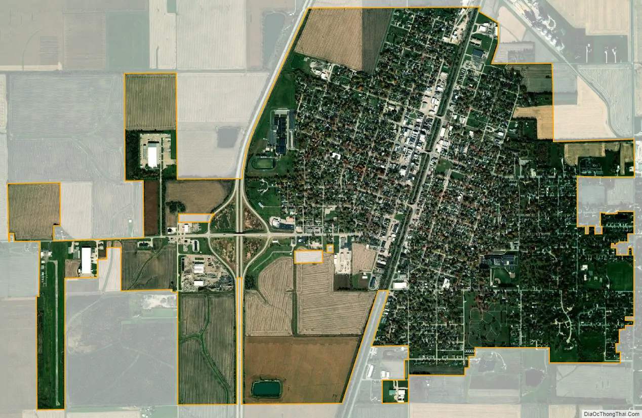
Paxton city Satellite Map
Geography
Paxton is located at 40°27′31″N 88°5′45″W / 40.45861°N 88.09583°W / 40.45861; -88.09583 (40.458745, -88.095784).
According to the 2010 census, Paxton has a total area of 2.3 square miles (5.96 km), all land.
Paxton is directly served by three major highways (I-57, U.S. Route 45, and Illinois Route 9), the Illinois Central Railroad, and a municipal airport with a 3,500 feet (1,100 m) landing strip [1].
See also
Map of Illinois State and its subdivision:- Adams
- Alexander
- Bond
- Boone
- Brown
- Bureau
- Calhoun
- Carroll
- Cass
- Champaign
- Christian
- Clark
- Clay
- Clinton
- Coles
- Cook
- Crawford
- Cumberland
- De Kalb
- De Witt
- Douglas
- Dupage
- Edgar
- Edwards
- Effingham
- Fayette
- Ford
- Franklin
- Fulton
- Gallatin
- Greene
- Grundy
- Hamilton
- Hancock
- Hardin
- Henderson
- Henry
- Iroquois
- Jackson
- Jasper
- Jefferson
- Jersey
- Jo Daviess
- Johnson
- Kane
- Kankakee
- Kendall
- Knox
- La Salle
- Lake
- Lake Michigan
- Lawrence
- Lee
- Livingston
- Logan
- Macon
- Macoupin
- Madison
- Marion
- Marshall
- Mason
- Massac
- McDonough
- McHenry
- McLean
- Menard
- Mercer
- Monroe
- Montgomery
- Morgan
- Moultrie
- Ogle
- Peoria
- Perry
- Piatt
- Pike
- Pope
- Pulaski
- Putnam
- Randolph
- Richland
- Rock Island
- Saint Clair
- Saline
- Sangamon
- Schuyler
- Scott
- Shelby
- Stark
- Stephenson
- Tazewell
- Union
- Vermilion
- Wabash
- Warren
- Washington
- Wayne
- White
- Whiteside
- Will
- Williamson
- Winnebago
- Woodford
- Alabama
- Alaska
- Arizona
- Arkansas
- California
- Colorado
- Connecticut
- Delaware
- District of Columbia
- Florida
- Georgia
- Hawaii
- Idaho
- Illinois
- Indiana
- Iowa
- Kansas
- Kentucky
- Louisiana
- Maine
- Maryland
- Massachusetts
- Michigan
- Minnesota
- Mississippi
- Missouri
- Montana
- Nebraska
- Nevada
- New Hampshire
- New Jersey
- New Mexico
- New York
- North Carolina
- North Dakota
- Ohio
- Oklahoma
- Oregon
- Pennsylvania
- Rhode Island
- South Carolina
- South Dakota
- Tennessee
- Texas
- Utah
- Vermont
- Virginia
- Washington
- West Virginia
- Wisconsin
- Wyoming