Hodgkins is a village in Cook County, Illinois, United States, and is an industrial suburb of Chicago. The population was 1,500 at the 2020 census, down from 1,897 at the 2010 census.
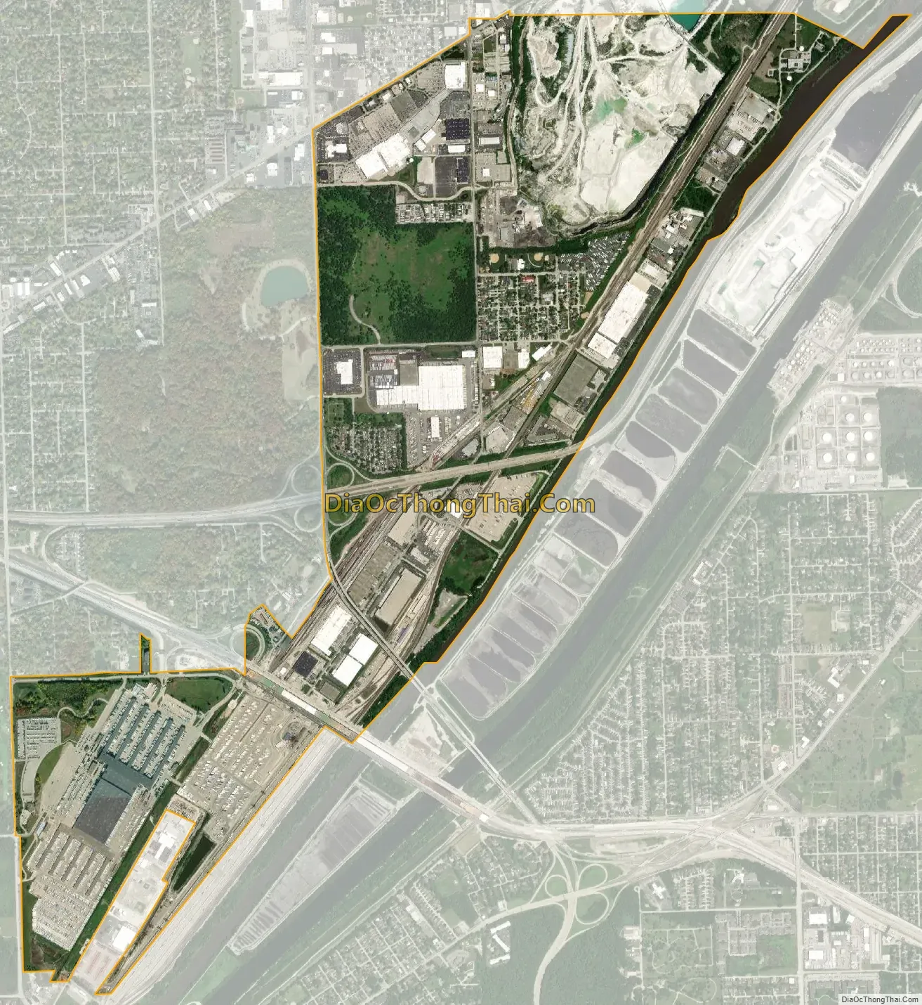
A United Parcel Service facility, known as CACH, is located in Hodgkins at 1 UPS Way. CACH employs over 9,000 people and is the “largest package sorting center in the world”.
| Name: | Hodgkins village |
|---|---|
| LSAD Code: | 47 |
| LSAD Description: | village (suffix) |
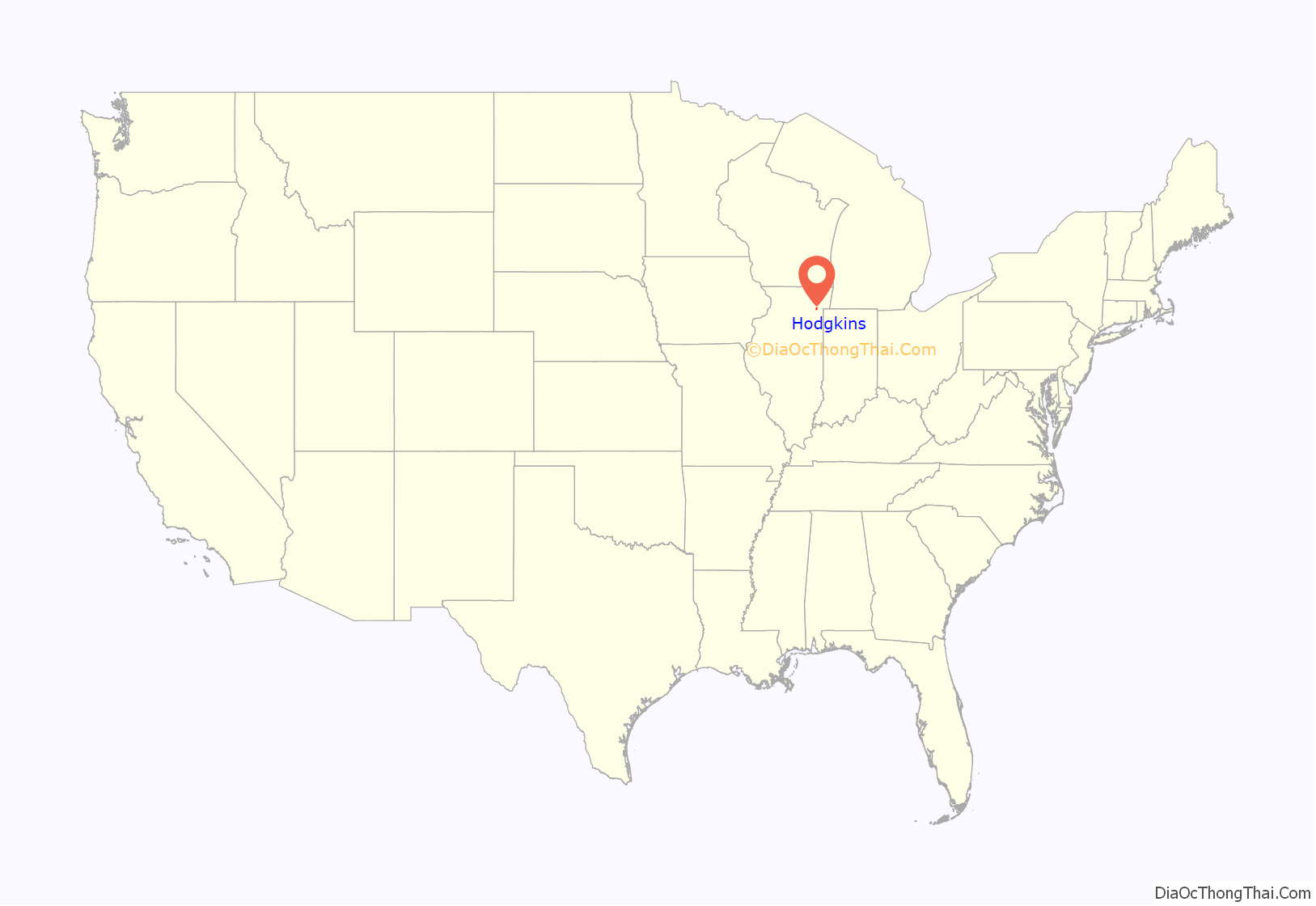
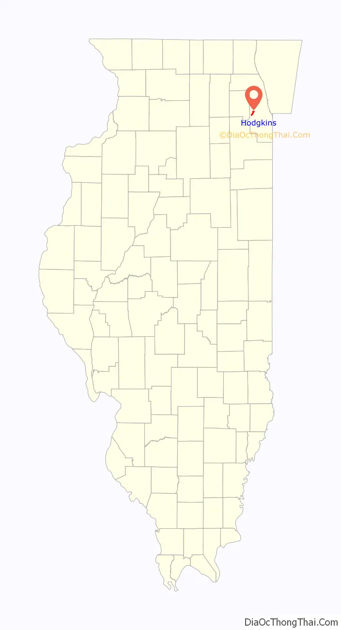
| State: | Illinois |
| County: | Cook County |
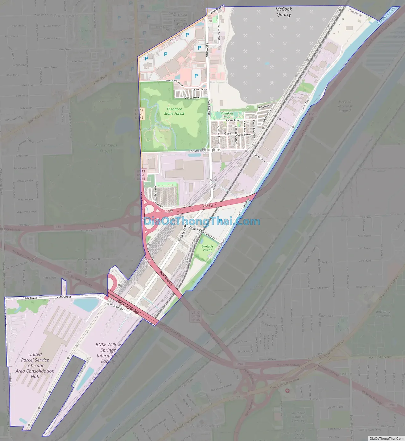
| Total Area: | 2.77 sq mi (7.16 km²) |
| Land Area: | 2.71 sq mi (7.02 km²) |
| Water Area: | 0.05 sq mi (0.14 km²) |
| Total Population: | 1,500 |
| Population Density: | 553.10/sq mi (213.54/km²) |
| Area code: | 708 |
| FIPS code: | 1735385 |
| Website: | www.villageofhodgkins.org |
Online Interactive Map
Click on ![]() to view map in "full screen" mode.
to view map in "full screen" mode.
Hodgkins location map. Where is Hodgkins village?
History
The first European visitors to present-day Hodgkins, explorers Jacques Marquette and Louis Joliet, paddled down the Des Plaines River in 1673, passing through the area, making their camp in present-day Summit. Settlement in the area, however, was somewhat stagnant until the early 19th century. It was at this time, around 1836, that Irish and Italian immigrants came to the area to work on the Illinois and Michigan Canal. The construction and eventual operation of the canal was responsible for the formation of many villages presently located along its banks, including Hodgkins. The I&M Canal is still in existence, located about 1 mile (1.6 km) south of Hodgkins. The canal and its adjacent land, now known as the I&M Canal National Heritage Corridor, was designated a National Heritage Corridor by Congress in 1984. The I&M Canal National Heritage Corridor is rich in historic sites, nature preserves, and wildlife, and stretches from Chicago to LaSalle–Peru.
The village of Hodgkins was originally known as Gary, a name locals claim was derived from “Garibaldi”, in recognition of the large number of Italian laborers working in an area grain mill. After several name changes, the Village of Hodgkins was incorporated in 1896. Jefferson Hodgkins, the president of the Kimball and Cobb Stone company, which was also the first business to locate in the village, was the man for whom Hodgkins was named. Modesto Lenzi, the somewhat dubious “King of Gary”, became the village’s first president that same year.
Patrick Crowley murder
Modesto Lenzi was unsuccessful in his 1909 reelection bid. Lenzi was defeated by L. E. Thatcher in an election that contemporary newspaper accounts called “a political feud between the prohibition and liquor interests”. The election campaign raged hotly for several months, culminating in Lenzi’s ouster. On the night of June 14, 1909, the crowd gathered in Hodgkins during and after the election became unruly. Village marshal Patrick Crowley, in an attempt to restore order, placed Modesto Lenzi, who was allegedly inciting the crowd, under arrest for disturbing the peace. As Crowley was bringing Lenzi to the jail: “A shot was fired in to his breast by some person in a crowd of alleged Lenzi sympathizers gathered about.”
The Fort Wayne News reported the following on June 14, 1909:
The shooter, believed to be Modesto’s brother, Harry, escaped and a manhunt ensued.
On June 22, 1909, a grand jury concluded:
On December 23, 1909, it was reported by the Logansport Pharos newspaper that the charges of murder against Modesto Lenzi and John May had been dropped. The paper reported that Assistant State’s Attorney Benedict J. Short told Judge Kersten’s court that the state had no evidence against the defendants. Harry Lenzi, known locally as “Rio”, disappeared immediately after the shooting and was never seen again.
Marshall Crowley was buried at Mount Olivet Cemetery in Chicago.
Hodgkins Road Map
Hodgkins city Satellite Map
Geography
Hodgkins is located at 41°45′51″N 87°51′34″W / 41.76417°N 87.85944°W / 41.76417; -87.85944 (41.764181, −87.859384).
According to the 2021 census gazetteer files, Hodgkins has a total area of 2.77 square miles (7.17 km), of which 2.71 square miles (7.02 km) (or 98.05%) is land and 0.05 square miles (0.13 km) (or 1.95%) is water. It is located just over 3 miles (5 km) from Chicago’s western city limits.
See also
Map of Illinois State and its subdivision:- Adams
- Alexander
- Bond
- Boone
- Brown
- Bureau
- Calhoun
- Carroll
- Cass
- Champaign
- Christian
- Clark
- Clay
- Clinton
- Coles
- Cook
- Crawford
- Cumberland
- De Kalb
- De Witt
- Douglas
- Dupage
- Edgar
- Edwards
- Effingham
- Fayette
- Ford
- Franklin
- Fulton
- Gallatin
- Greene
- Grundy
- Hamilton
- Hancock
- Hardin
- Henderson
- Henry
- Iroquois
- Jackson
- Jasper
- Jefferson
- Jersey
- Jo Daviess
- Johnson
- Kane
- Kankakee
- Kendall
- Knox
- La Salle
- Lake
- Lake Michigan
- Lawrence
- Lee
- Livingston
- Logan
- Macon
- Macoupin
- Madison
- Marion
- Marshall
- Mason
- Massac
- McDonough
- McHenry
- McLean
- Menard
- Mercer
- Monroe
- Montgomery
- Morgan
- Moultrie
- Ogle
- Peoria
- Perry
- Piatt
- Pike
- Pope
- Pulaski
- Putnam
- Randolph
- Richland
- Rock Island
- Saint Clair
- Saline
- Sangamon
- Schuyler
- Scott
- Shelby
- Stark
- Stephenson
- Tazewell
- Union
- Vermilion
- Wabash
- Warren
- Washington
- Wayne
- White
- Whiteside
- Will
- Williamson
- Winnebago
- Woodford
- Alabama
- Alaska
- Arizona
- Arkansas
- California
- Colorado
- Connecticut
- Delaware
- District of Columbia
- Florida
- Georgia
- Hawaii
- Idaho
- Illinois
- Indiana
- Iowa
- Kansas
- Kentucky
- Louisiana
- Maine
- Maryland
- Massachusetts
- Michigan
- Minnesota
- Mississippi
- Missouri
- Montana
- Nebraska
- Nevada
- New Hampshire
- New Jersey
- New Mexico
- New York
- North Carolina
- North Dakota
- Ohio
- Oklahoma
- Oregon
- Pennsylvania
- Rhode Island
- South Carolina
- South Dakota
- Tennessee
- Texas
- Utah
- Vermont
- Virginia
- Washington
- West Virginia
- Wisconsin
- Wyoming


