Maywood is a village in Proviso Township, Cook County, Illinois, United States in the Chicago metropolitan area. It was founded on April 6, 1869, and organized October 22, 1881. The population was 23,512 at the 2020 United States Census.
| Name: | Maywood village |
|---|---|
| LSAD Code: | 47 |
| LSAD Description: | village (suffix) |
| State: | Illinois |
| County: | Cook County |
| Total Area: | 2.72 sq mi (7.04 km²) |
| Land Area: | 2.72 sq mi (7.04 km²) |
| Water Area: | 0.00 sq mi (0.00 km²) |
| Total Population: | 23,512 |
| Population Density: | 8,653.66/sq mi (3,340.70/km²) |
| FIPS code: | 1747774 |
| Website: | www.maywood-il.org |
Online Interactive Map
Click on ![]() to view map in "full screen" mode.
to view map in "full screen" mode.
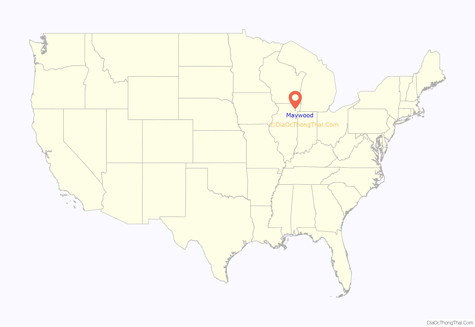
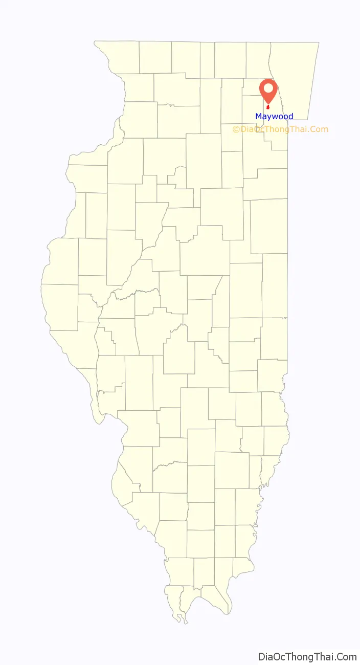
Maywood location map. Where is Maywood village?
History
There was limited European-American settlement in the Maywood area before a railroad was built after the American Civil War, which stimulated the rise of Chicago. At least one house in what became Maywood is known to have been used as a station on the Underground Railroad, to aid refugee African-American slaves in escaping to freedom in the North. Some settled in the free state of Illinois; others went on to Canada, which had abolished slavery, seeking further distance from slavecatchers. The site of the former house has been nationally commemorated. The plaque is located at today’s Lake Street and the Des Plaines River bridge.
This early West Side suburb of Chicago was developed along the oldest railway line that led away from the city. It attracted real estate developers because of its open grass prairie and scattered groves of ancient trees.
In 1868, Vermont businessmen established the Maywood Company. In 1870 it organized the platting of streets, and began construction on the north side of the Chicago Great Western railroad tracks. The company planted 20,000 eight-year-old, nursery-grown trees to enhance the future town. By 2010, the last of these 148-year-old trees had succumbed to the emerald ash borer.
The oldest documented ash tree in northeast Illinois is in Maywood and is dated at 250 years old. It is being protected from the borers with horticultural treatment. The danger is expected to pass locally by year 2020, as it already has in Canton, Michigan, where borers were first seen. The ash is nicknamed “The Great Dane”, after Jens Jensen, founder of the Midwest’s prairie ecology movement a century ago. The tree is located within old growth woods just behind Proviso East high school.
With settlement underway, the village was founded on October 22, 1881, by Colonel William T. Nichols. He named it after his late daughter, May, and the groves.
Many century-old homes survive here in relatively unaltered condition. Maywood boasts 17 homes and properties listed on the National Register of Historic Places.
At one time two airports operated in Maywood. Loyola University Medical Center was developed on the site of one former airport, at the southwest corner of First Avenue and Roosevelt Road. It was the airfield used by Charles Lindbergh during his days as an airmail pilot.
Checkerboard Field was located at the southeastern corner of that intersection and was a private field. The land has been converted to a forest preserve meadow. There was some apparent consolidation of the fields in later years. Later, an automobile board racetrack was located here, along with a viewing grandstand. Barney Oldfield raced on the track. The Hines Veterans Hospital constructed one of its buildings on the foundation of the former grandstand.
Maywood in World War II
Maywood was established as the base for the 33rd Tank Company, Illinois National Guard. The Armory was located on Madison Street, two blocks east of First Avenue. It was organized on 3 May 1929 with the purpose of training men for combat. On 25 November 1940, 122 men of the 33rd Tank Company were inducted into active service to become Company B of the famous 192nd Tank Battalion, which fought in the Philippine islands. Many of these American soldiers were taken prisoner by the Japanese and died in April 1942 on the Bataan Death March. Of the 122 men of Company B, only 41 survived the war to return to Maywood. Their sacrifice has been honored with an annual Bataan Day Parade.
Given such losses, Ian Smith, who headed the history department at Proviso East High School, said that “World War II hit the town of Maywood really hard.”
Historic homes and buildings
Maywood Fire Department
Mid-century Bungalow
Jennie S. Thompkins House
Harry H. Nichols House
Robinson House
Fred Hampton, president of the Illinois chapter of the Black Panthers Party in the late 1960s, lived as a child in Maywood with his family for ten years. With the Black Panthers, he initiated community education and health programs for children, food for needy families, and other developmental projects. He was killed at the age of 21 in December 1969 in a police raid at his apartment in Chicago. In 2019, his family and supporters initiated a GoFundMe campaign to buy and restore his childhood house, to operate as a museum and community center. As of March 2021, they had exceeded their fundraising goal.
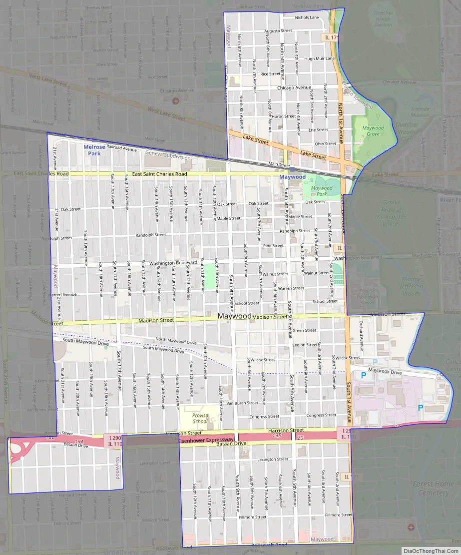
Maywood Road Map
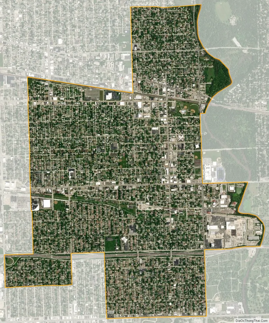
Maywood city Satellite Map
Geography
According to the 2021 census gazetteer files, Maywood has a total area of 2.72 square miles (7.04 km), all land.
Neighboring villages are Broadview to the south, Forest Park and River Forest to the east, Melrose Park to the north, and Bellwood to the west.
See also
Map of Illinois State and its subdivision:- Adams
- Alexander
- Bond
- Boone
- Brown
- Bureau
- Calhoun
- Carroll
- Cass
- Champaign
- Christian
- Clark
- Clay
- Clinton
- Coles
- Cook
- Crawford
- Cumberland
- De Kalb
- De Witt
- Douglas
- Dupage
- Edgar
- Edwards
- Effingham
- Fayette
- Ford
- Franklin
- Fulton
- Gallatin
- Greene
- Grundy
- Hamilton
- Hancock
- Hardin
- Henderson
- Henry
- Iroquois
- Jackson
- Jasper
- Jefferson
- Jersey
- Jo Daviess
- Johnson
- Kane
- Kankakee
- Kendall
- Knox
- La Salle
- Lake
- Lake Michigan
- Lawrence
- Lee
- Livingston
- Logan
- Macon
- Macoupin
- Madison
- Marion
- Marshall
- Mason
- Massac
- McDonough
- McHenry
- McLean
- Menard
- Mercer
- Monroe
- Montgomery
- Morgan
- Moultrie
- Ogle
- Peoria
- Perry
- Piatt
- Pike
- Pope
- Pulaski
- Putnam
- Randolph
- Richland
- Rock Island
- Saint Clair
- Saline
- Sangamon
- Schuyler
- Scott
- Shelby
- Stark
- Stephenson
- Tazewell
- Union
- Vermilion
- Wabash
- Warren
- Washington
- Wayne
- White
- Whiteside
- Will
- Williamson
- Winnebago
- Woodford
- Alabama
- Alaska
- Arizona
- Arkansas
- California
- Colorado
- Connecticut
- Delaware
- District of Columbia
- Florida
- Georgia
- Hawaii
- Idaho
- Illinois
- Indiana
- Iowa
- Kansas
- Kentucky
- Louisiana
- Maine
- Maryland
- Massachusetts
- Michigan
- Minnesota
- Mississippi
- Missouri
- Montana
- Nebraska
- Nevada
- New Hampshire
- New Jersey
- New Mexico
- New York
- North Carolina
- North Dakota
- Ohio
- Oklahoma
- Oregon
- Pennsylvania
- Rhode Island
- South Carolina
- South Dakota
- Tennessee
- Texas
- Utah
- Vermont
- Virginia
- Washington
- West Virginia
- Wisconsin
- Wyoming


